

Norman Smith
@Norman_Wx
Followers
4,427
Following
1,178
Media
3,696
Statuses
22,458
God First | Proverbs 3:5-6 | 21 | Ohio U. Meteorology | Professional Drone Pilot | Chasing w/ @SevereStudios | Contact: gs730821 @ohio .edu |
Southeast Ohio
Joined April 2018
Don't wanna be here?
Send us removal request.
Explore trending content on Musk Viewer
Russian
• 1078442 Tweets
Putin
• 589603 Tweets
Rich Homie Quan
• 430952 Tweets
Cristiano Ronaldo
• 235509 Tweets
Argentina
• 222959 Tweets
Chiefs
• 151110 Tweets
Messi
• 149892 Tweets
San Marino
• 131006 Tweets
#GHEstreno
• 70526 Tweets
Linkin Park
• 62193 Tweets
From Zero
• 49058 Tweets
Bolivia
• 37630 Tweets
Mahomes
• 36840 Tweets
مانشيني
• 36249 Tweets
Lamar
• 33809 Tweets
سالم
• 31994 Tweets
Chester
• 31188 Tweets
Di María
• 31158 Tweets
Emily Armstrong
• 23496 Tweets
De Paul
• 20267 Tweets
Vargas
• 19542 Tweets
Travis Kelce
• 16239 Tweets
Colin Gray
• 13064 Tweets
National Anthem
• 12482 Tweets
Derrick Henry
• 11123 Tweets
Fideo
• 10850 Tweets
The Emptiness Machine
• 10378 Tweets


Pinned Tweet

Proverbs 3:5-6: “Trust in the lord with your heart and lean not on your own understanding; in all your ways submit to him, and he will make your paths straight”
4
9
103

Random loud BOOM from Reeds stream, don’t know what in the world that was.
56
136
1K
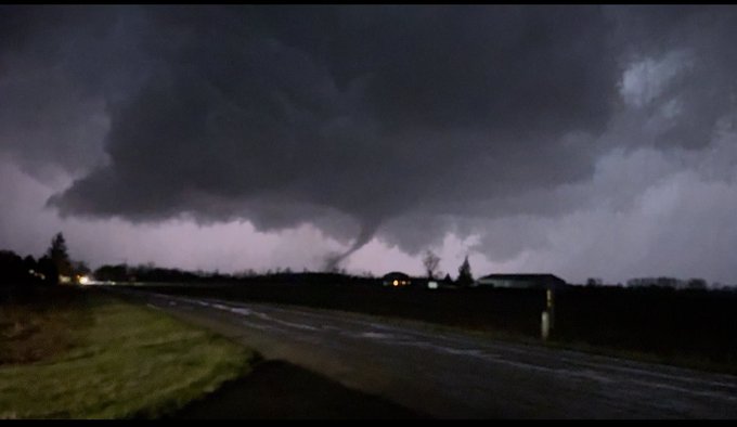
Multi-Vortex tornado captured on drone SE of Athens, OH roughly an hour and a half ago! Contact
@JordanHallWX
at
@SevereStudios
.
#ohwx
@NWSCharlestonWV
@WSAZnews
@dougharlowWCHS
15
215
744


Significant tornado damage west of Webberville, MI on I-96. Cars and semis thrown, significant tree damage. Contact
@JordanHallWX
@SevereStudios
for licensing.
#miwx
9
141
381
BEAUTIFUL Large Tornado just to the south of Dinwiddle, Virginia. (Contact
@koryhartman
for licensing).
@weatherchannel
@accuweather
@WeatherNation
#vawx
13
63
305
Intense tornado intercept earlier from outskirts of Clarksville, TN. Loud roar with debris in air…praying everyone’s okay. Licensing contact
@JordanHallWX
at
@SevereStudios
.
#tnwx
8
98
300
First time I’ve ever been seriously nervous during a storm chase. High end Moderate or High doesn’t matter….this is setting up to be a dangerous day across IL/IA as well as down south in S MO/E AR

12
48
269


Edited video of an intense - violent tornado on the west side of Clarksville, TN proper from yesterday…unreal roar
#tnwx
8
47
223
Working on the next video for the channel! Comment what you think the strongest tornado is of all time and why. Comments will be used in the video!

79
22
214
This right here is a BIG Problem for tomorrow, this is the bulk shear on the HRRR. Those vectors are almost perfectly parallel to the front even out across the warm sector. With no cap as well, this just spells instant cluster/linear storm mode….

7
25
218
Reed currently not happy with some of the viewers on the live stream..which I agree with Reed’s response
17
14
202

Horrific damage from Indian Lake, OH. Trees denuded, homes completely destroyed, horrible sight too see. Drone video will be posted tonight.
#ohwx


6
62
207
Tornado otg west of Milton center, OH. Cone shaped tornado before being fully wrapped in rain
@NWSILN


2
66
202
AND on top of that, let’s not forget she compared Israel to Nazi Germany.
#IStandWithPresTrump
18
52
127


Textbook OH River Valley Long Track Intense-Violent tornado sounding.

11
30
185


With that being said I’m not chasing this setup tomorrow; I would highly advise first time Dixie chasers to NOT chase this unless you are with someone that has a lot of experience…make smart decisions y’all.
15
14
156
Large Wedge Tornado Crossing Highway 281 near Spaulding, NE - Contact
@koryhartman
for licensing at
@SevereStudios
1
28
149
CSU’s new forecast continues to remain bullish for Tuesday & especially Wednesday across the Midwest -> OH Valley. SPC mentioning an upgrade to a 30% contour in future outlooks for Wednesday as well.


3
29
151


LIVE west of Fort Dodge, IA waiting for supercell initiation later this evening, all hazards possible with strong long track tornadoes not out of the question. Stay tuned to watches/warnings!
#iawx
7
14
141


Palm Sunday Twins > Pilger Twins


10
5
60
10
8
142
Vortex Dynamics in hilly / mountainous terrain is something I’m very interested in & would love to do research on throughout my meteorological career. This tornado was captured in just a couple miles south of Athens, OH. Notice the parent tornado weaken & broad out as it rides up
7
14
140
Ensemble agreement for the beginning of April is quite scary across the Ohio Valley. While we have 5-7 days and a lot of things to digest as we get closer, this is sounding of all alarm bells for a potential big time event (IF things fall in the right place). A lot can / will


7
29
137
Scary new HRRR run as it shows prefrontal supercells ahead of an ongoing squall with on going embedded supercells in the line. Tuesday is definitely shaping up to be scary, I’ll have a video posted tonight discussing this upcoming setup


8
20
134

My shot of the tornado from earlier tonight near Gary, IN. Wild.

1
14
132

Here’s a sneak peak of one of the tornadoes I managed to capture near Greenville / Covington, OH. FULL video will be out tomorrow afternoon.
#ohwx
7
22
125
TOP 5 CHASES OF 2022:
1) Crowell, TX Tornado Family (first time ever seeing twins!) - 5/4/22
2) Palmer, IA EF2 - 4/12/22
3) McKenney, VA EF0 - 11/11/22
4) Gallipolis, OH MCS - 6/13/22
5) Loyal, OK Tornadoes - 5/2/22


6
12
128

Totally forgot I had this on my camera roll, scrolling through & found this from one of Reeds livestreams LOL
6
8
123

HRRR proximity sounding from the Wapakoneta, OH tornado from yesterday. Unbelievable. Still would say that’s one of the most intimidating tornadoes I’ve ever seen next to Bremen/Hartford, KY from Dec 10, 2021.

6
9
121
Here at this address in Bremen and holy cow….


In addition to this two-story home being completely swept away from its foundation near Bremen, part of the concrete foundation has disappeared. Notice how part of the driveway is literally scoured away. This is as extreme as tornado damage gets.


18
106
439
2
24
120
Dude I’m worried for my good friend
@marcusreynold19
…his dot was right over the CC and it hasn’t updated..tried calling him and went straight to voicemail
11
17
124


Tuesday looking possibly better than yesterday….unreal. Chase mode activated w/ the legend
@JTMediaOH

3
11
122
Environment is looking unreal across NE MO/W IL & SE IA….any supercell that can get going would have a shot at producing long track/strong - violent tornadoes if this environment holds.


10
26
119
More violent tornado damage in NW Side of Dawson Springs, GPS messed me up and led me to this side of town…unbelievable.

5
25
116
After talking about solar eclipses in Astronomy lecture today, this has gotten me very hyped for the next Solar Eclipse on April 8th, 2024. Just imagining a shot of a total solar eclipse on Lake Erie....gives me chills.

13
14
113
Wouldn’t be shocked if Tuesday got the red sharpie for S OH / N KY / SE IN for the risk of strong, long-tracked tornadoes. Favorable shear vectors off of a diffuse cold front should favor semi-discrete supercells until the overnight hours as the trough advances east
10
17
115

LIVE from Wilmington OH ahead of a potential tornado outbreak across the OH River Valley
3
12
110
From my Snapchat, amazing tornado near Loyal, OK 20 min ago full video tonight! You don’t wanna miss it!
@ryanhallyall
@ReedTimmerAccu
2
23
112
I seriously can’t believe it


Jaw is on the floor…full unedited drone video of the Athens, OH tor will be published tonight! A high based, lp, multi vortex tornado over rolling hills?! Can’t get any better than that. Full chase video coming out Monday! CANT MISS content
2
1
29
2
6
111

This is probably one of the most insane observed soundings I’ve ever seen. Folks in the OKC metro need to watch these isolated cells coming in

2
17
109

Really worried for the populated areas that will be under the gun on Sunday. While dealing with the bigger cities/suburbs, you also have a lot of towns in between the regions. Feel excited to get a chance to get a tornado in my region but also worried for people. Please stay
9
14
105
Bad damage on zI-96 cars tossed, trees down significant / intense tornado. Just came on damage a minute after

1
18
104
Violent sounding on NAM 3km for OKC. Cap broken but no storms firing on dryline man I’ve seen this before (cough cough 4/14/12)

6
12
106
Dynamics for the 28th look extremely concerning across the OH Valley / MS River Valley on Wednesday. 15% contour was just added by the SPC but could definitely see this getting upgraded pending how models keep resolving this solution of the trough


5
13
105
21z RAP vs 03z RAP at 20z; significant shift north of the low & wf along with a more northward shift across the RRFS….pretty speechless


10
15
104
Yeah with a shadow of a doubt I believe I just caught my first tornado just west of Cheshire, OH. Video will be posted tomorrow for both supercells!
@ReedTimmerAccu
@NWSCharlestonWV
@BrandonCopicWx
@SpencerWeather

4
13
100


Friday looking like a TP tornado factory in NE MO/W IL/E IA

11
10
103


You know somethings up when the owner/builder of the home has issues with the rating of his structure (btw this was the home that was well-built and swept with his foundation damaged and tossed….

8
19
98
Picture of the Gary, IN tornado from last night as it knocks out transformers. Beautiful LP supercell w/ textbook RFD cut wrapping around as the tornado was underway.
@NWSChicago
#ilwx

7
14
101
That was seriously the most random tornado I’ve ever seen in my 3 years of storm chasing. Somehow this small supercell managed to produce a cone - bowl multi-vort for 3-4 minutes near Castine, Ohio. Wanted to get a closer vantage & when I got passed a tree line it had a huge


3
14
100
Heres my thoughts....any semi discrete supercell that we can get will have the chance to produce strong-violent tornadoes & likely be long track.....15# looking more likely with the recent trends on RAP/HRRR
3
10
98

Later this month, I will be collaborating with
@ConvChronicles
for an upcoming video on Tornado Forecasting for Spring - Summer of this year using ENSO, PDO, AO, NAM, etc. Stay Tuned!

9
5
98
NEW Outlook/Target map for Friday! Best severe weather chance is further north along the WF/TP across KY/OH River Valley...VERY strong shear with ample low-level thermodynamics could result in a STRONG tornado threat. More conditional severe weather threat could materialize

9
30
94
Good stuff today Reed! Career chase. Glad to see you again along with
@JordanHallWX


Monster
#tornado
right after Dominator 3 intercept with
@JordanHallWX
@Sierra_Lindsey3
@BrianAllenWX
@accuweather
68
443
3K
1
7
97
Going to get backlash from this….may lose followers. Oops. Make your own list here. Really curious to see y’all’s results. (P.S Waffle House would be S Tier).

48
5
94
STRONG SUSTAINED TROPICAL STORM FORCE WINDS here on Jekyll Island GA WOW! Waiting for isolated supercells approaching this area. Tornado watch is in effect
#gawx
7
11
91
Looking at this morning it is tough to ignore the dryline in N IL….probably imo one of the best environments overall so far this year. Very good instability profiles mixed with more backed southerly surface winds. Don’t typically throw this word around a lot but I’m highly


2
16
95

4
52
83