
Convective Chronicles
@ConvChronicles
Followers
9K
Following
9K
Statuses
4K
One-stop shop for in-depth forecast discussions and case studies for upcoming and past severe weather events across the United States.
Joined April 2022
@dethsight It’s just difficult to get adequate instability for charge separation in winter environments
0
0
1
@Solomon_WX In radiation fog, longwave radiation is transferred from near the surface to the air above it. As a result, the shallow layer of near-surface air cools to the dewpoint, it becomes saturated, condensation occurs, and you get fog.
0
0
4
@RoncaHohn I was not the most pleased last night. Dallas Love Field is not the most conducive place for sleeping.
0
0
3
SPC has outlined a Slight Risk (level 2/5) across Tennessee today for a few rotating storms/line segments with a risk for mainly damaging winds and large hail. The tornado threat is low but nonzero.

2
9
40
@DJonesBagOBones I'm more referring to any situation...you just have to pull over for LE vehicles with lights on. During severe weather events, LE have bigger fish to fry than policing chasers. Personally, I just don't think it's going to be that big of an issue.
1
0
1
@DJonesBagOBones We already do that stuff anyway for vehicles with sirens/lights, and licensed chasers will make up a very small fraction of chasers on the road in a given event, so pulling over for them will be a rare occurrence.
3
0
1
@MesoscaleMikey You can tell the folks who wrote this have zero knowledge about severe weather.
0
0
7
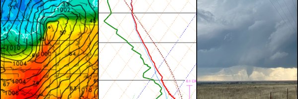
SPC has outlined a Slight Risk for increasing confidence in overnight/early-morning supercells across parts of Kentucky/northern Tennessee with an associated tornado threat.

2
10
74