

Kathryn Prociv
@KathrynProciv
Followers
13K
Following
29K
Statuses
41K
Meteorologist for @NBCNews🦚, EVP @monarchweather🦋. Emmy Award-Winning. Former @WeatherChannel @capitalweather @ustornadoes🌪. MS & CCM #GoHokies! Views my own
Joined October 2010
RT @WxNB_: More acres have been burned by wildfires in January 2025 across California than in all the Januarys of the past 30+ years combin…
0
116
0
It’s an out of this world night tonight in New York City! Mars, Jupiter and Venus all visible. We can’t see a lot of stars here, but the planets always come through! 🌌


0
0
5
Some zoomed in views of forecast rainfall amounts over the Palisades, Eaton and Mountain Fire burn scar areas. Watching Pacific Palisades, Altadena, Pasadena and Malibu extra closely this weekend for debris flow concerns. #CAwx


1
0
4
RT @US_Stormwatch: Extreme drought has returned to Southern California for the first time in over two years, as San Diego and LAX experienc…
0
318
0
RT @ericfisher: Lafayette, Louisiana saw more snow today than Philadelphia, NYC, Salt Lake City, Chicago, and Minneapolis have seen *ALL SE…
0
375
0
RT @NWSMobile: ❄️ SNOWFALL RECORDS ARE FALLING! 6.2 inches of snow at Mobile Regional Airport breaks the all-time snowfall record (the 2-d…
0
292
0
RT @SERCC: Getting close to the greatest 1-day Snow on record for Mobile, AL... @NWSMobile @WeatherMatrix @Heather…
0
4
0
First #Blizzard Warning issued by @NWSLakeCharles! Sticks out on the map that's for sure!


NWS Lake Charles has issued it's first ever Blizzard Warning for Jefferson and Orange counties as well as Cameron, Calcasieu, Jeff Davis, Acadia, Vermilion and Lafayette parishes until noon today.

1
2
7
RT @NWS_BaltWash: Given a noon temp of 27°F at Reagan National Airport (Official D.C. weather observation), today's Inauguration will now r…
0
30
0
Tomorrow the Extremely Critical fire risk includes not just near Los Angeles, but also far southern California and portions of the eastern San Diego foothills into the San Jacinto Mountains. #CAwx

0
1
1
RT @hausfath: Every wildfire starts with an ignition – downed powerlines, lightning, arson – and we can do a lot to reduce these. But in C…
0
402
0
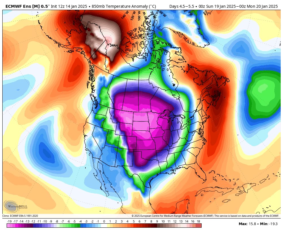
Great discussion @webberweather! Can definitely see the more westward lean in the EURO vs. GFS. Thanks for the tip! 🥶


My experience with these brutally cold Arctic air masses that get dumped on/near the Rockies is that they usually sink southward more quickly than models lead you to believe in the medium range, and end up getting dumped a bit further west like the eps/geps has shown for days Pouring this kind of cold air into a mid level trough will entice it to dig more quickly & the +PVa created above the low to mid level cold dome (a stable layer), “drags” the trough base further west.
0
0
2
Both the Palisades and Eaton fires have made the list for Top 20 Most Destructive California Wildfires, sitting at #3 and #4, respectively. The Eaton fire has made the list for Top 20 Deadliest California Wildfires, sitting at #11. The Palisades Fire will be added to this list too. *15 of the 20 most Destructive California Wildfires have happened in the last 10 years (since 2005). 18 out of 20 since 2003. *13 of the 20 Largest California Wildfires have happened in the last 10 years (since 2015). 19 out of 20 since 2003. *8 of the 20 Deadliest California Wildfires have happened in the last 10 years (since 2005). 12 out of 20 since 2003.


2
12
27
RT @Weather_West: In 2024, Southern California experienced an exceptional episode of wet-to-dry hydroclimate whiplash. Very wet conditions…
0
39
0
Last time country saw 50%+ #snow cover was last January when CONUS approached 60%! Another notable time was February 2021 following the major Texas freeze event.

By Saturday morning, this map of America's weirdest #snow hole (upper Midwest) should look even more distinct, before some light snow moves in later this weekend.

0
0
4