
Jadonwx
@Jadon_wx
Followers
934
Following
804
Media
698
Statuses
17,315
🇫🇷🇮🇹🇲🇽| 16 | #FTTB | #DifferentHere |Passionate for weather | 🌪️= 2 (5 funnels) | Tornadoes are fascinating but can leave devastating impacts.
Columbia, SC
Joined September 2022
Don't wanna be here?
Send us removal request.
Explore trending content on Musk Viewer
#GMMTVMUSICONxCAMBODIA
• 156085 Tweets
#FayeBDPartyInNanning
• 130348 Tweets
CWR x CeraVe Cleanser
• 40302 Tweets
CHEER UP ARTIST FOURTH
• 20895 Tweets
オースティン
• 14571 Tweets
花火大会
• 12344 Tweets
UNLV
• 12221 Tweets
サウジアラビアRC
• 11924 Tweets
Syracuse
• 11667 Tweets


Pinned Tweet

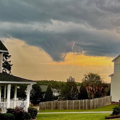
Likely funnel cloud (it was rotating from what I saw and on radar) near my house in Blythewood, SC!
#scwx
@SCweather_wx
@NWSColumbia


2
12
53
@StormChaserGabe
Vertical hot tower. It just means blowing up convection (usually means it’s still strengthening btw)
9
13
923
What in the 2024?!?!?
Earliest Cat 5 in the Atlantic basin on record
One of the strongest tornadoes in history
Random violent tors on 10%#< days
G5 Aurora
Total solar eclipse
WHAT IN THE WORLD.
20
58
440

Ik everyone is talking about the debarked tree shown here, but is that roads pavement partially peeled off?!?!

Greenfield has fully debarked Hardwood trees. Not good..


21
124
520
28
27
377
We’re really gonna get a grasp of the devastation that took place tonight across the affected areas when there’s first light…
Horrible damage, never imagined it to be this bad… Pray for these people 🙏


9
109
374
Another unwarned tornado 🤦♂️ (The urge to tag NWS Memphis rn is real.)


16
20
300
Beryl can’t handle dry air they said, Beryl can’t handle shear they said, Beryl won’t reorganize they said. Well guess what? It’s 2024!
13
13
167
OMG Kiln, MS just got hit by an extremely dangerous and intense/violent tornado. Please pray for them.

9
18
144
2024:
The year of the donut hole
The year of the vio-tor
The year of the deviant tors
The year of tors spawning out of nothing
The year of all seasons
The year of the 2020s
8
9
139
No DI on the complete slabbed home in Elkhorn, NE? (Not sure if it was going under construction or not.) It seems that most on the left side of the neighborhood was unserveyed to as of now. Could just be because they haven’t determined a proper rating for those homes yet though…


14
12
112
If the NAM3k is right then it would almost certainly go High risk on Saturday with an expansive 10%# from what I think is gonna be WI down to AR and into Central OK and TX.
Time will tell, and we have to wait for the HRRR to get in range though… (Sounding taken near Tulsa btw)


4
23
100
My early weenie predictions for the max D1 outlook for each day for this upcoming severe weather sequence. (Book mark it I dare you)
Thursday - ENH
Friday - MDT
Saturday - HIGH
Sunday - ENH
11
7
89
Hmm, I wonder if they would do an emergency upgrade to high risk if the storm mode looks very discrete within the next hour or 2? 🤔

7
8
88
Do you agree with this list I made for what I think are the most powerful tornadoes based on intensity? (Not in order)

54
7
77


Which one will verify today? 🤔 The CIPS, CSU, Nadocast, or the SPC?


15
11
71
This is the likelihood of a tornado in March based off my interpretations. (I will take any positive or critical feedback!)

16
10
71
I’m honestly frustrated and sad that the SPC keeps making huge mistakes lately. My trust and confidence is dropping for them (No I don’t dislike them.) But recently they haven’t done to well (As far as the tornado risk goes)
Ex: 3/14, 3/25, 4/1, 4/9, 4/10, and possibly today.
24
6
67
This might be a big problem around 8 PM - 2 AM CDT when the LLJ kicks in. Those cold pools and outflow boundaries didn’t really hinder the thermodynamics nearly as much as we thought…

2
9
56


What’s better?
G5 Aurora
505
Total solar eclipse
291
Photogenic stovepipe
271
Red sprites and lightning
74
18
3
56
“Not a tornado year”
“Year of the bust”
“2024 will be below average, mark my words”
What happened to that? The real ones knew this was a Late April-June year. (July could be a lil sneaky to 😉)
4
4
58
Highest DBZ seen on reflectivity so far this year?
Texas ❌
Mexico ❌
Oklahoma ❌
Cuba ✅

7
3
54
What’s the scariest type of tornado?
Multiple-vortex
295
Horizontal-vortex
108
Wedge
485
Nocturnal
794
43
2
53
It looks like there is going to be a high-end multi-day severe weather system based on model run consistency and agreement. Also the CSU, CIPS, and the SPC all highlighted a very large and broad region for severe weather on day 5. Severe weather is likely from days 4-7
#wx

3
10
51
Sulphur, Okemah, Springer, Marietta, Ardmore, and much more just got devastated by monsters… Not to mention, yesterday was already bad enough. I’m in utter disbelief, awe, and confusion. Such a horror for the communities affected. Please send them help and prayers 🙏
2
9
50
2
0
49
Small pre-mature supercell already rotating south west of Evansville, KY.


3
11
47
My timeline:
Drama
BS
Some weird story
“WWIII”
NAM going wild on Monday
“Monday is a bust”
Tuesday is stealing Monday’s Thunder
5
3
47


@SammyWxNY
Idk if they were overworked or overwhelmed since they weren’t issuing tornado warnings all day 😅; I could be wrong though…
(We all know which NWS office I’m talking about.)
1
1
41

@49ersSportsTalk
Purdy breaks Kirko curse ✅ Purdy lead a game winning drive under Shanhan in the playoffs ✅ 3rd youngest qb to make the SB ✅ over comes a 17 point deficit at half time in the NFC championship (which was never done before) ✅ best QBR this season ✅ and people are still hating.
1
0
39
What did I tell y’all… Don’t believe the CAMs by the day of, surface obs reveal the true story of how the day could unfold.
#wx

@IrontenzWX
I think the moderate will shift more into IN, also usually CAMs are better with the environment than they are with storm mode. They either over-convect or under convect, Therefore I think they keep the 15%# (If not make it larger).
Surface obs > CAMs
1
1
5
3
5
41


How many tornadoes will there be from Thursday to Sunday?
1-20
197
21-45
260
46-85
235
86+
223
12
1
37


I will make a poll because yes. So answer. What would you rather try and survive?
C5 hurricane on an island
668
EF5 (Above Ground level)
232
Mag 9 quake and Tsunami
137
The Tsar bomba
46
19
4
37
Some of y’all are so immature bruh, there’s no way you’re calling it a “bust” when we haven’t even gotten close to peak tornado time. Y’all are the same ones that said 11/4/22, 3/24/23, 12/9/23, and 1/9/24 were gonna bust. Wait till the event is over you clowns 🤡
#wx
6
2
36


OMG it’s almost like there are NEXRAD radars just perfectly sitting in the middle of the circles, WHAT COULD IT BE??? 😱😱😱


2
1
35


No way the lowest precip tor oat just touched down after the supercell went over my house, right?


3
2
35
What’s your guys’ very early prediction for the max risk on Monday? (4/15)
High risk 😈
229
Moderate risk 😤
377
Enhanced risk 😶
105
Slight risk 🤮
38
15
3
33

More damage photos from Winchester, Indiana.
Images from Tammi Myer on Facebook.


0
10
34
You guys remember when storm net had high probs for a tornado happening in Little Rock on March 14th but nothing happened because of the outflow boundary interaction? Yeah same thing might save Witchita Falls, TX today.


4
5
33
Today could have a *sneaky* setup in the Carolinas and extreme southern Virginia with a conducive environment for tornadoes (Maybe strong ones possibly).
I have seen 10%# risks go for less, than an environment like this before… Surface obs and model trends need to be watched.


3
1
31
Not sure why the SPC doesn’t have an enhanced risk for wind and sig hail in central South Carolina and North Carolina. These storms are heading into an even more explosive environment that will still keep building over the next couple hours. Over 8 LLRS and 3000+ cape.


3
4
28

@kodstrangeer
He’s not wrong. There’s a difference between supporting Hamas terrorists and supporting innocent Palestinians 💀
1
0
30


The SPC made the slightest adjustment in the Carolina’s just to exclude me 😑 (My luck pt.idk)


6
1
27
Which state is performing the best this evening into tonight?
Nebraska
106
Kansas
219
Oklahoma
61
Texas
35
10
3
26
Thermos are overperforming quite a bit today… (For instance: max LLRS were supposed to be 7, max cape around 2k, and max 3k cape around 125…)
@SCweather_wx
; I think it’s safe to say the Carolina’s might be back 🔥


2
2
26
Read the alt text. ->
This is based on April only and the “Greatest” risk is in place for the areas that I *think* can experience a couple of severe weather/tornado outbreaks; NOT all areas in the “Greatest” risk will be affected, but some/most areas likely will.
#wx
#wxtwitter

1
7
26
To the people thinking 2024 is not a tornado year I’m just gonna remind you that it wasn’t supposed to be an “early season” type of year like the ones we’ve had recently, it’s actually supposed to get active in the peak of spring. 2011, 2010, and 2004 all had slow starts…
5
3
25
@Shadowiscold
@NFL
@49ers
Keep crying we had 3 times as many penalties and that “1st down” was clearly short. You sound dumb.
3
0
24

How many Moderate/high risk(s) will April get this year?
0
41
1-2
155
3-4
86
5+
37
2
5
26


Geez… (Yes ik it’s the GFS and it’s still far out but it’s still holding in the medium range unlike EVERY setup this year that has fallen apart.) This could go big; take with a bucket of salt until we’re in the short range btw.


1
4
25
What will the max outlook area be for April 1st?
High risk 🤯
48
Moderate risk 😳
236
Enhanced risk 🥱
106
Slight risk 😂
17
3
3
23
Guys if you see drama on your timeline just ignore it and move on,
I swear the wx Twitter community can be pretty immature when the weather is quite lol. (Thank God the weather awakens later this week into early next week)
1
1
23
@In2ThinAir
Me when I like to fear monger the public, gaslight them into thinking what I think, blame the government for my accusations and have no proof because nothing happens when he “predicts it” and says the weather is controlled by the government even though we saw a massive trough-
14
1
22
If there’s an EF5 (Which there’s a 0.000001% chance cuz of the EF scale and building codes) today I will do whatever the top comment says (don’t be to excessive please.) There will not be EF5(s) today 😅
16
2
23
Tropical storm/Hurricane ✅
Thunderstorm ✅
Hail storm ✅
Tornado ✅
Flood ✅
Wind storm ✅
Land slide ❌
Snow storm ✅
Ice storm ✅
Waterspout ✅
Avalanche ❌
Volcano ❌
Earthquake ✅
Wild fire ❌

Have you ever experienced a natural disaster? (Earthquake, tornado, hurricane etc...)
99
7
90
5
3
20
Bright ahh sun 😱 (Face reveal for the people that haven’t seen the 1st one)

2
0
22


How unpredictable is 2024, as far as severe weather?
Easy to predict (L I A R)
11
In the middle
22
Pretty difficult
69
EXTREMELY HARD WTH
107
3
3
21
@TornadoClipss
Greensburg type shi. That’s an insane feat, especially for the fact that it wasn’t even that wide and went over the damaged areas rather quickly with a forward speed likely above 55mph. That’s actually insane.
1
0
21
Me and
@MarcussenA79245
called it 🥱 (I just didn’t want to post it on Twitter because some of y’all don’t know how to react on this app and just start BS.)


3
2
21
How did yesterday perform in your opinion?
#wxtwitter
Performed
11
Under-performed
91
Bust
145
Bust of the year.
81
6
6
20
“Confidence is higher in Isolated to widely scattered supercells across parts of the SC Mid and Lowlands and far south east NC near and south of the sharp warm front.” 🤔 I think this is what the NAM was showing (overnight nocturnal supercells after 5 PM EST?) Mid level drying-

1
5
19
Tomorrow is the literal definition of “it only takes one” (Although we could also have way more than just one). The environmental parameters are at extreme levels for tomorrow evening and night 😬
3
4
19
Y’all saying it’s gonna bust don’t get that there is still 500+ minutes on the tornado watch and the peak of the event will be around 2 AM 💀 wait till the event is over, y’all said the same thing about 03/24/23. Some of y’all either overhype or just don’t listen. Be patient.
1
5
20


What’s the most interesting to track in real time? (On radar and for storm chasing)
Tornadoes
171
Derechos
32
tropical storm/Hurricanes
18
Other
4
7
1
20