

sammy
@SammyWxNY
Followers
413
Following
405
Media
444
Statuses
2,509
Certified sabres fan and wxtwitter bully. mower of lawns, wacker of weeds. insta: sam.leisenring #Road2Gold #LetsGoBuffalo #BillsMafia
in your walls
Joined July 2013
Don't wanna be here?
Send us removal request.
Explore trending content on Musk Viewer
Putin
• 695385 Tweets
Kamala
• 267155 Tweets
Vice President Trump
• 256782 Tweets
Katy Perry
• 143092 Tweets
VP Trump
• 125996 Tweets
#loveislandusa
• 118956 Tweets
Flamengo
• 112748 Tweets
Eduardo
• 76888 Tweets
ESPYs
• 61199 Tweets
Serena
• 59972 Tweets
#ROMANCE_UNTOLD_OutNow
• 47861 Tweets
バイデン
• 46752 Tweets
Jana
• 42565 Tweets
XO OUT NOW
• 42447 Tweets
Allan
• 37961 Tweets
Botafogo
• 35626 Tweets
Kenny
• 34984 Tweets
Fortaleza
• 33936 Tweets
renjun
• 32701 Tweets
#bidenpressconference
• 31354 Tweets
NEW OST BY NUNEW
• 30337 Tweets
スタフィー
• 27294 Tweets
音楽の日
• 24853 Tweets
Food Bank
• 21871 Tweets
BLOSSOM
• 20788 Tweets
Ferreira
• 20319 Tweets
Kaylor
• 16874 Tweets
Gabigol
• 16177 Tweets
Hulk
• 15413 Tweets
Pulgar
• 13153 Tweets
#يوم_Iلجمعه
• 12826 Tweets
Luciano
• 11676 Tweets


Pinned Tweet

With some cloud cover ending my aurora viewing tonight, my encounters with the May 2024 geomagnetic storms have come to a close.
An unforgettable experience. Truly blessed to have seen god’s creation in full force.


2
1
12
If an NWS office fails to issue warnings for tornadoes that are clearly on the ground and doing damage, maybe it’s a sign that their employees are being overworked/overwhelmed?
When there’s a localized tornado outbreak like last night, I think nearby NWS offices should help pick
32
22
390
is there a way to cancel a spotter network report i’m at work and 100% certain my brother is on my laptop 😭

15
21
379

4
0
279


@KBBM_24
@CBSNewsNZ
Who are you talking about? This is Bernie Gores. He was loved by many here in Conway, South Carolina.
1
2
107

I don’t like posting single solution models past 120 hours but this is completely insane.


18
7
131
2
26
120
A closet gay going on a religious rant about how homosexuality is a sin, really is some of the funniest shit I’ve seen on wxtwitter 😂😂 ifykyk
14
4
104
Tuesday is a real boom or bust. Like major tornado outbreak or poopy fartass.
7
6
98
“bust”
it’s literally 4pm and we have 10+ tornado reports ain’t no bust

11
8
94

From NWS Wichita’s area forecast discussion regarding Saturday
“strong to potentially violent tornadoes” is something we haven’t seen mentioned in quite some time.
Although trends can change, Saturday really has the potential to be a high-end tornado event. Not something to

3
18
92
Of course all this shit happens after they drop the 15% tornado risk
4
3
90
Extreme instability, weak shear, and supercells moving due south/southwest, in Texas?
Looks familiar…
10
6
87
The Marietta-Dickson OK tornado has been assigned a preliminary 170mph EF4 rating.


2
14
86
Outbound velocities were maxed out on radarscope with the tornado near Hollister OK. G2G velocity near 260mph!!!
If someone has a link to the spreadsheet that estimates tornado intensity I’d love to implement this data


4
12
85
@RyanWx_
@greenba29480803
I promise you it wasn’t me my brother made that report from my laptop 😭
Changed my pw so hopefully doesn’t happen again
1
0
82
18z GFS pulled up with a 988mb surface low and a 50kt low level jet. Potent solution for Tuesday.


4
9
80
Bulk shear vectors almost perfectly perpendicular to the dryline?
You couldn’t ask for a more discrete storm mode.


4
10
79
@statmuse
Chet is still a rookie no reason to compare these two. But I’ll take the guy anchoring a top 5 defense in the league
3
0
78
@911Dispatcher45
@CBSNewsNZ
They were triplets, all named Bernie Gores with different middle names. Bernie Richard Gores died in Afghanistan. Bernie McGravy Gores died in Ukraine. Bernie Samuel Gores died in this mass shooting. It’s heartbreaking to see all 3 brothers died in the span of a year. RIP💔🕊
3
1
67


The Enhanced Fujita scale is flawed and very inconsistent. It often doesn’t indicate the actual strength of a tornado. I think that DOW data should be implemented when applicable
The Saffir-Simpson scale for tropical cyclones isn’t damage based, so I don’t see any reason why
18
12
73
If tomorrow doesn’t go MDT it will bust. 10 # risks in 2024 are cursed man
9
1
70
@matmcdonut
I have a feeling that most women wouldn’t feel safe around a guy who looks like this 😂

6
1
68

why does tyler metcalf use an AI altered photo of himself as his profile pic 💀

15
2
66


@BJ_KING999
Rest easy Perell! Prayers out to his parents, Ambutakam and Ambasing during this difficult time ❤️🕊
2
2
52


@tsukioverknots
No. If the owner is an animal rapist it should be taken away. You disgusting freak
2
1
56


This is how you know we’re entering peak climatology
The 2024 tornado season is just getting started


1
5
59
*supercell with hook and couplet on radar*
*multiple tornado reports with photo evidence*
NWS Dodge City:

2
2
58
Lots of wxtwitter drama after a tornado outbreak, as is tradition.
Moral of the story:
EF scale is flawed.
Don’t drive like an asshole.
Saturday verified, but not how we expected it to.
Don’t steal tornado media.
Don’t monetize tornado damage media. (I’m talking about you
7
8
57
5
0
56

When the never convecting, usually linear biased if it does 3k NAM fires discrete supercells, you know something’s up. Tomorrow is definitely a day to be weather aware!

4
9
53
mfs screaming bust when there isn’t an EF5 at exactly 6pm
if you simpletons read the forecast discussion it’s supposed to be an after dark event 💀
3
2
52
What a surprise (not), the 3k NAM yet again outperforms the HRRR.


3
4
50

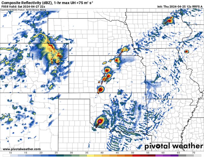
12z RRFS with a supercell explosion by 5pm in the plains on Saturday. Any storm in the open warm sector could be strongly tornadic given the favorable parameter space.
6
2
47
Classic example of a rear flank nudger leading to a significant tornado. This prompted a tornado emergency in middle Tennessee a little bit ago.
0
8
47


@ModernWarzone
Who cares about free skins. Call of duty sucks anyway. Hasn’t been any good since BO2
5
0
43
NAM is still on board with a solution favoring discrete tornadic supercells. Timing of the trough ejection is a little slower compared to the first run suggesting more of an overnight threat with this solution. Keep in mind this is the NAM at hour 78 so things can change and


2
10
46
0
0
39


@WxGabe
Broyles gets a lot of flack for his forecasts but he knows more about tornadoes than just about anyone on this planet. Incredibly smart guy
4
0
43
Impressive signal from today’s 12z GFS run. Trending towards a possible significant severe weather event on Monday.
#wxtwitter


2
3
44
Lots of hubbub about the possible messy convective mode on Saturday.
If it means anything, the 3z RAP solution could favor a more discrete mode at least initially. Bulk shear vector orientation in respect to the dryline has a pretty solid degree of perpendicularity, especially


2
2
44
If it weren’t for a very stubborn cap, we could have seen a tornado outbreak in Oklahoma tomorrow night. Very intense shear profiles. As of now it appears the cap will be too strong and CAMs don’t show any convection down there.
#wxtwitter


5
5
42
@BBCAfghanNews
I thought Bernie Gores died last year when the Wendy’s chili factory in Beirut exploded. Now he’ll be appearing offline forever 😢
0
0
34