
Gabe Garfield
@WxGabe
Followers
11,292
Following
2,453
Media
1,520
Statuses
9,053
Meteorologist & storm chaser | Helping new chasers find tornadoes | Posts about tornadoes, forecasting, and applied science | | Ps 77:18
Monthly tornado news & tips🔗
Joined September 2013
Don't wanna be here?
Send us removal request.
Explore trending content on Musk Viewer
Bia Souza
• 337243 Tweets
Kyle
• 229685 Tweets
Teddy Riner
• 117975 Tweets
サッカー
• 115948 Tweets
Leon Marchand
• 110959 Tweets
スペイン
• 91203 Tweets
オフサイド
• 90639 Tweets
Enrique Márquez
• 85907 Tweets
Emily
• 60742 Tweets
Sunderland
• 55847 Tweets
Julián
• 48407 Tweets
Ekrem İmamoğlu
• 46588 Tweets
Ron Paul
• 41856 Tweets
Arabia
• 38941 Tweets
İsrail
• 33502 Tweets
Game Informer
• 24480 Tweets
#Sismo
• 16346 Tweets
#ErdoğanınYanındayız
• 14574 Tweets
Mariana Pajón
• 14370 Tweets
Joshua Cheptegei
• 11091 Tweets
Hepimiz Erdoğan'ız
• 10893 Tweets
Equi
• 10747 Tweets


Pinned Tweet

A bit of news!
I'm excited to announce that I'm now offering one-on-one chase forecast consultations.
If you're chasing in the next few days, I have a few slots available tomorrow night and Thursday night.
Check it out here:

9
18
154
It has taken me 11 years to post this.
On 4/13/12, an aggressive chase maneuver I made almost ended badly.
We punched north through a high-precip supercell near Cooperton, OK and saw this low visibility tornado. It didn't seem like a bad choice...
1/11
80
402
5K
I’ve chased tornadoes for almost 25 years. And in that time, only one has ever chased me.
It was, of course, the El Reno, OK tornado of 5/31/13.
It was 2.6 miles at its widest, had winds > 300 mph, and moved faster than 50 mph.
For the first time, here is my full story:
1/25
98
415
4K
"Twister" is a movie many storm chasers & meteorologists love to hate.
And no surprise, since 90%+ of it is complete fiction. But it made me wonder, what did it actually get right? So I rewatched it.
As a chaser, here are 10 things that I believe "Twister" nailed:

77
126
2K
The last EF5 tornado to officially hit the United States struck Moore, Oklahoma on 5/20/13.
And, for the last ten years, I believed that this storm's intensity could be attributed to an outflow boundary.
It turns out, I was wrong.
1/8

29
138
1K
So I guess the Violent Tornado Parameter has a maximum value😬

17
143
1K
Some thoughts on today's High Risk:
1. The atmosphere will be uncapped by 1 pm. So, storms could fire early.
2. If they fire early, shear will be limited. But strong low-level CAPE/stretching could result in tornadoes regardless.
3. Rich moisture will linger closer to I-35. So

12
187
1K
The most violent tornadoes can produce winds in excess of 300 mph.
While researching for my master's at OU, I learned that, theoretically, these winds may be even stronger.
Here's the atmospheric process that makes this possible:
1/12
29
151
1K
Thankfully, yesterday’s High risk underperformed significantly.
Forecasters, including msyelf, will have to dig into what we missed.
But there is no doubt that that environment was exceptional — as evidenced by the powerful tornado that hit Barnsdall, OK.
34
37
897

Sulphur just took a direct hit form a tornado. East side of town — power out.
12
203
823
The sound of the wind here is the stuff of nightmares

16
103
830
Man, those helical vortices

11
75
773
New to tornado forecasting?
In my experience, it can take a while to figure out the best resources to make a part of your forecasting routine.
So, in case it's helpful, here is a list of sites that I've found useful:
1/7

15
97
727
Have you ever wondered what it looks like when a tornado is coming right for you?
Well, you might see something like this. This stovepipe directly hit this filming spot 3 minutes after we abandoned it.
November 7, 2011 near Snyder, OK
21
65
683
Phew, last night was — a lot.
We came upon some pretty sad scenes after the Sulphur tornado. The worst of which was a collapsed apartment building on the east side of town.
One of my chase partners helped pull 3 people alive. But there were more missing.
16
93
670
It's been more than 10 years since the El Reno tornado.
And unfortunately, some of the chase lessons from that tragedy have faded.
Regardless, those insights are still useful for staying safe.
Here are 6 things we re-learned from that awful day:
1/9
10
102
655
Writing this thread re-sparked my curiosity about the El Reno Tornado.
So I decided to re-read the Wurman et al. (2014) article about the data the DOWs captured that day.
Their findings still blow my mind.
Here are 5 nuggets that I found particularly impressive:
1/7
I’ve chased tornadoes for almost 25 years. And in that time, only one has ever chased me.
It was, of course, the El Reno, OK tornado of 5/31/13.
It was 2.6 miles at its widest, had winds > 300 mph, and moved faster than 50 mph.
For the first time, here is my full story:
1/25
98
415
4K
17
80
642
10 years ago near El Reno, OK - the most dangerous tornado I've ever chased.
Not only was it the strongest tornado ever observed, but it was also the largest. And it changed directions/speeds in ways never seen before.
Truly, a once-in-a-lifetime storm.
16
129
624
As soon as we wheeled around, I realized there was a tornado to our *southwest*.
Time to move. Fast.
A *huge* tornado was right next to us.
6/11
9
20
634
One of my fondest memories is the breakfast hour that I shared with Tim Samaras in Pratt, Kansas on 5/19/13.
The night before, we had both chased the ultra-photogenic Rozel EF4 tornado. And that day would offer more opportunities to see nature its most violent form.
So the

16
48
619
On this date 10 years ago, I witnessed the most beautiful supercell-tornado combo of my chase career near Burwell, Nebraska.
The tornado was almost an afterthought compared to the storm above it.
Truly unforgettable!

12
81
600
Storm mergers matter.
One study found that ~50% of tornadic supercells produce their 1st tornado within minutes of a storm merger (Rogers and Weiss 2008).
And a new study by Fischer and Dahl (2023) has found that these mergers follow 4 distinct patterns:
1/6
13
91
591
The F4 Hallam tornado, just after it had wedged out
Later, it became so wide that you couldn't capture it in a single frame. Satellite tornadoes formed multiple times.
As darkness fell, it grew to a then-record 2.5 miles wide as it hit the Nebraska hamlet.
5/22/04
16
88
577

This happened one year before El Reno.
I'd love to say that this experience caused me to change my ways immediately. But it didn't.
But seeing what happened on May 31, 2013 solidified it for me.
11/11
15
7
565

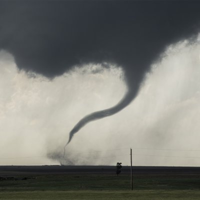
Sub-sub-vortex? 🤔

Check out this insane whip-like subvortex with the violent
#tornado
south of Greenfield, Iowa captured by the Dominator Drone. I launched the bird north of the tornado and passed the controls to
@theScantman
who tucked the drone in behind the vortex.
@EdgarONealWX
@ConnorWX

56
334
3K
10
24
558
On this date in 2016, this powerful tornado formed near Sulphur, Oklahoma.
Damage surveyors only found evidence of EF3 damage.
However, 3-second wind gusts measured by mobile radar exceeded 200 mph.
11
57
550
The beginning of the infamous 2.5 mile-wide F4 tornado that hit Hallam, NE on 5/22/04.
The supercell was so large when it hit Hallam that I mistakenly thought that it had become a squall line (it hadn't).
Only the El Reno tornado in 2013 was wider (2.6 mi).
The setup:
7
66
504
NEW VIDEO
If you're new to storm chasing, or would just like to brush up on your meteorology, I've just uploaded a beginner's meteorology video to YouTube.
I cover:
-Surface maps
-Upper air maps
-Skew-T Log-p charts
-Hodographs
Enjoy!

19
96
512
Here is the Moore, Oklahoma EF5 tornado as it reached peak intensity on 5/20/2013.
I've never seen stronger motion in a tornado. The motion in the sidewall was absolutely violent.
What was crazy was seeing huge debris flying upward -- like 5x as high the funnel.
9
70
498
The May 3, 1999 tornado outbreak is one of the most infamous of all time.
But did you know that it almost didn't happen?
A science article by Thompson & Edwards (2000) showed how 3 unexpected atmospheric developments set the stage for an historic violent tornado event:
1/9

12
70
492
Reading through Broyles et al. 2023. Fascinating!
Apparently, the genesis of most intense tornadoes (EF3+) are preceded by 2 things:
1. An rear-flank downdraft surge that channels ultra-strong inflow
2. A descending reflectivity core that organizes/protects vertical spin
1/5


4
59
503
Most storm fans know about the infamous the Greensburg, KS EF5 tornado on 5/4/07.
But did you know that the storm became even more impressive after it hit town?
For almost 30 min, it produced simultaneous wedges near Trousdale and Hopewell - both greater than 1 mi wide!

24
45
499
Here is a new edit of the Burwell, NE tornado.
This occurred on June 16, 2014—the same day as the infamous Pilger EF4 tornadoes.
#TornadoTuesday

12
79
485

11 years ago today, I had the most horrifying storm chase of my life.
Here is my account of the EF5 tornado that hit Moore, Oklahoma on 5/20/13.

13
82
476

On May 31, 2013, I had the most harrowing experience of my chase career.
A 2+ mile-wide tornado, with winds greater than 200 mph, chased me for about 15 minutes.
Here is my story:
12
62
460
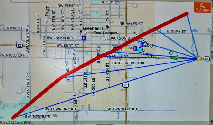
Here is a map that shows approximate locations for all 3 tornadoes.
7/11

4
11
456
3. We relied too much on the wisdom of the crowd. Safety is the responsibility of the people in the car.
10/11
2
8
441
Today is already massively overperforming. And it's not even 2p CT.


2
38
429
Obviously, there were (at least) a few mistakes here:
1. I was too aggressive in positioning. Wanting to get great video can get you into trouble.
2. I didn't take our escape route as soon as we lost situation awareness.
9/11
2
7
418
Tornado with classic supercell structure northeast of Windthorst, Texas on 5/25/24
This was one of at least 4 tornadoes we saw from this storm.

15
48
405
... because the tornado was moving northeast -- or at worst, east. We were south of it, so I figured we were safe.
And since the contrast was getting worse, I asked our crew to inch closer for a better view.
2/11
2
10
404
20 years ago tonight, this F3 tornado tracked just south of Mulvane, Kansas.
Though small, it tossed a vintage Ford Mustang over 400 yards.
And besides its power, it was also visually stunning:
I've been chasing storms for 25 years, & I haven't seen anything more photogenic.
16
57
402
One of the most challenging aspects of chasing is targeting the right area.
Here's a fun exercise. This is a real tornado case in mid-late May. Let's say it's just after 3p. SPC risk is below. How would you pick a target?
Here's how I might narrow it down (reveal at end):
1/16

28
41
398
Here, we realized that the tornado wasn't completely E of the road as we had thought.
This was disorienting, because it did not fit my mental model of what was happening.
Seeing other chasers ahead provided some mild comfort, so we moved northward.
4/11
2
9
390
Rain began to enshroud us. We were becoming increasingly uncomfortable with our location.
My buddy noted that others were getting out of there. He suggested we get out of there. I reluctantly agreed.
We could see a satellite tornado just to our north.
5/11
1
9
387
Breaking out one of the "greatest hits" for
#Lightning
Tornado with lightning near Burwell, NE on June 16, 2014

7
45
388
Here is the route we took that day.
All told, we spent more than 15 minutes in the direct path of the tornado.
25/25

15
7
382
Extremely wide and strong tornado near Sulphur, OK on 5/9/2016
McKeown et al. (2020) examined mobile radar data collected during this event. Their findings are amazing:
- 200 mph 3-sec gusts
- >220 mph instantaneous gusts
- 425 mph velocity difference across circulation

14
57
374
Sunray, Texas - June 9, 1971
IMO, this image set is still the gold standard for photogenic tornadoes.


June 9, 1971:
According to the NCDC database, a pair of F4s touched down in the Texas Panhandle near Sunray and Gruver. However, according to
@sigtor2019
's analysis, neither tornado produced violent damage. The twister near Gruver was reportedly up to two miles wide.
#wxhistory


1
7
41
2
39
380
This enormous tornado formed near Sulphur, Oklahoma on May 9, 2016.
Mobile Doppler radar recorded winds up to 230 mph in the funnel. However, damage surveys only found evidence of EF3 damage.
Amazingly, a boy survived the heart of the tornado in the center of his house:
15
52
366
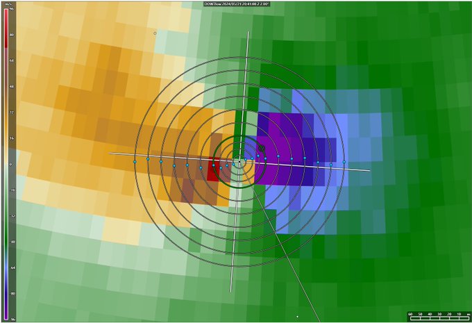
So Greenfield is likely in the top tier of radar-measured violent tornadoes…
Assuming the 290 mph is verified and is not exceeded, only Bridge Creek 1999, El Reno 2011, and El Reno 2013 had higher winds.

Very prelim analysis of DOW data show
>250 mph peak winds, possibly high as 290, at 44 m (144 ft) above ground in Greenfield, IA. Tornado very intense & also very small, so worst winds were in narrow swath. Raw data from DOW7 (L); Prelim DOW-measured center path. POD blue dot (R)
64
652
2K
5
59
362
Before El Reno, before Hallam, there was Mulhall.
This violent tornado, which occurred on May 3, 1999, had some impressive stats:
-Max velocities at least 240 mph
-Width was 4x greater than Bridge Creek
-Winds >110 mph extended over 1.5 mi diameter
(From Wurman 2002)

12
42
350
Here is the Sulphur, OK EF3 tornado at maximum intensity (5/9/2016).
Recommend that you turn up the audio. The roar was *very* audible at this location.
This was the atmospheric setup:
7
55
337
Based on KFDR's base velocity (7:35P CDT), it looks like there may have been some sort of tornado cyclone scale Fujiwhara event.
And we were in the center.
8/11

5
7
345
Mature stage of long-lived tornado near Dodge City, Kansas on 5/24/16

1
34
338
To give a little perspective, the 1st image shows what radar looked like when punched the storm.
The second shows our position relative to the tornado.
A key factor in our decision was that the storm was not tornado-warned when we decided to punch. Moments later, it was.
3/11


3
10
335

May 3, 1999.
To those outside of Oklahoma, this date means very little. But to those Okies who survived the largest tornado outbreak in state history, “May 3rd” is forever branded into our collective conscious.
Here is my story from that day:

9
45
337
Sometimes, it's hard to remember how you began.
And that's definitely true for long-time chasers. We sometimes forget how hard it was for us in the beginning. And when I started, I was really bad at it.
So I thought it might be helpful to tell how I became a chaser:
1/12

16
26
333
Tornado models have long shown that the greatest tornado wind speeds are in the vertical (possibly, near the speed of sound). But radars can’t measure the vertical (quasi horizontal only).
If data quality is good, this could be the first true vertical velocity measurement.
BREAKING NEWS!!! I just got off the phone with Matthew DuBois, Jerry Belk who found the ROCKET sensor with parachute just short of KC Airport! This is huge. Due to this miracle we will now have 10 Hz data for the entire flight inside EF4 tornado and 3D animation of its flight!
255
771
5K
11
47
321
If it had happened any other tornado day, the Winfield tornado would have been the headliner. But on 4/26/91, it was almost an afterthought.

12
37
322
Lightning lights up wedge tornado near Daykin, NE on 5/22/2004.
Later, as it passed through Hallam, the tornado widened to 2.5 miles across.
It received an F4 rating.

8
27
332
Here is a new edit of the Burwell, NE tornado.
This occurred on June 16, 2014—the same day as the infamous Pilger EF4 tornadoes.

11
36
325
My first view of the violent Sulphur, Oklahoma tornado on 5/9/2016.
After approaching the circulation from a nearly-opaque core, we were both excited and relieved to locate the tornado.
5
27
323
On this date 15 years ago, this long-lived tornado tracked over Goshen County, Wyoming.
VORTEX-2, a field experiment designed to understand what causes tornadoes, surrounded the tornado with instruments.
Radar, surface, and balloon data were all collected during the event.

11
32
329
Until April 26th, the U.S. tornado count was tracking below average.
But since then, it has been going nuts -- with no end in sight.

9
71
326
Extreme instability can compensate for lack of wind shear.
This tornado formed in an environment with relatively weak shear. Bulk shear was <35 kts and storm relative helicity was ~100 m2/s2. But the MLCAPE was over 5000 j/kg!
Near Rock, KS on 6/12/04
19
38
323
On 5/24/11, this EF4 tornado hit areas near Criner & Goldsby, OK.
Despite its narrowness, this vortex displayed incredible power.
It leveled houses completely, tossed vehicles extreme distances, and caused some of the most severe ground scouring I've ever surveyed.
1/6
15
38
318
1. Like Jo, some people have become storm chasers due to storm trauma.
For example, I became obsessed with tornadoes when my home town was hit by a tornado in 1990.

6
4
319
11/16/15 was the night chase of a lifetime.
This EF3 tornado tracked near Pampa, Texas, carving a 35-mile path through the rolling hills of the Panhandle.
It was just one of 10 tornadoes we observed over an almost-unbelievable 4 hours.

12
28
320
Has there been a supercell more explosive than the 5/22/2004 Hallam, NE storm?
It went from first echo to radar-indicated mesocyclone in 16 minutes.
Only rival might be supercell near Kingfisher on 5/3/99 (Storm H).
Any other candidates?
32
25
317
Multiple-vortex tornado entering the Wichita Mountains National Wildlife Refuge on November 7, 2011
6
37
313
Long-lived stovepipe tornado southwest of Dodge City, Kansas on 5/24/16

7
32
309
Another structure shot near Lakin, Kansas. Definitely a Top 10 structure day!

5
32
291
One of the biggest lessons I’ve learned in storm chasing:
Commit to a target storm as early as you can — but never earlier.
Tactical pauses can be helpful, to wait for more info to make the best choice.
But once you’ve decided, go for it immediately. Delays can be costly.

9
26
297
2. The meteorologists shown here actually use the concept of "breaking the cap" in the right context.
And this is **very** rare in this movie. haha

3
5
294
A powerful tornado moving through Moore, Oklahoma on May 20, 2013
At the moment this image was taken, the tornado was causing EF5 damage.

5
21
295
Yet another big severe weather day on Saturday...
And it checks all the boxes:
-negatively-tilted trough
-well-timed mid-level max
-strong low-level jet
-strong to extreme instability
2024 is becoming the Tom Brady of storm chase seasons.


13
37
294
It’s like the Allison,TX wedge from 6/8/95 — but with no rain
8
39
288
9. Debating EF-scale ratings before damage surveys have started is definitely a chaser pastime.

2
2
289
Inflow tail into Tulia, Texas supercell tail, immediately prior to tornadogenesis. Time: ~5:45 p on 5/7/19

13
33
279
Dual tornadoes southwest of Dodge City, Kansas on 5/24/16
This was one of at least six times this storm produced simultaneous tornadoes!
8
26
287
"Beauty is unbearable, it drives us to despair, because it offers us for a minute the glimpse of an eternity that we desperately want to stretch out over all of time."
-Albert Camus
3
44
282
This year’s storm season is emphasizing an obvious, but sometimes overlooked fact:
Environments favorable to strong and violent tornadoes are far more common than strong and violent tornadoes.
11
25
276
10. And tornadoes can be hard to see. Even when you're right there.

3
4
278
Four years ago, I missed out on the Pilger tornado-fest. But,
@SRHelicity
and I got a heckuva consolation prize near Burwell!

13
33
266
7. Storm chasers are individuals. But a lot of us get psyched before big chases.

3
4
275
On May 24, 2016, a single storm produced more than 12 tornadoes near Dodge City, Kansas.
Most of the tornadoes were tall and photogenic. But this one was a wedge -- nearly 0.5 mi wide.
This beast threatened to hit Dodge itself. But fortunately it recurved just in time.
10
28
276
NEW VIDEO!
I've just uploaded the companion video to Basic Meteorology.
This one covers advanced concepts related to tornado forecasting including:
-Steep lapse rates
-Moisture return
-Streamwise vorticity
-Storm initiation
-And more!
Enjoy!

10
42
270
I've lost a windshield during a storm chase only once.
And it was during the Tushka, OK EF3 tornado on 4/14/11.
We had 1 road option. But the tornado was tracking on it, felling trees. Meanwhile, baseball-sized hail was in the hook behind us.
Yeah, it was expensive. 😆
8
31
272
Uncomfortably close to a tornado with strong vertical motion near Canadian, Texas on 5/27/15
3
14
268
EF4 tornado approaching Bethel Acres, Oklahoma on 5/19/2013
This tornado was unusually loud. In fact, you could hear it from over 2 miles away.
The crazy part is that, when it was at its loudest, we couldn't see it over the treetops. It was freaky, to say the least.
8
25
270
Genesis of the 4th Dodge City, KS tornado on 5/24/16.
A study by Wakimoto et al. (2018) found that this tornado had a radar debris signature from its inception.
It's possible that debris fallout from the previous tornado may have been draw into the new one.
8
32
272
