
Western_Kansas_Wx
@300MphEF5
Followers
937
Following
617
Media
791
Statuses
2,154
Explore trending content on Musk Viewer
Zuckerberg
• 300671 Tweets
台風の影響
• 147640 Tweets
#SB19atGENTOsaKorea
• 72394 Tweets
LAMUGIN NYO SB19
• 71945 Tweets
P-POP IWAGAYWAY ANG WATAWAT
• 71496 Tweets
ACTORS
• 55976 Tweets
#DaruratKekerasanAparat
• 53906 Tweets
#BINIxBillboardKPower100
• 40393 Tweets
Romero
• 32175 Tweets
iPhone16
• 30342 Tweets
東出昌大
• 29084 Tweets
Vegetti
• 25872 Tweets
東出さん
• 16513 Tweets
コントローラー
• 11064 Tweets


Here’s a clip from
@ReedTimmerAccu
livestream about 20 minutes ago on the violent tornado near Cole Oklahoma, note the intense multiple vortices and extremely rapid rotation.
13
120
704
Extreme video out of Grand Isle Louisiana as Hurricane Ida makes landfall. 150+mph wind gust reported and catastrophic storm surge is occurring. This video was just before the surge cam was taken down, whole island likely underwater. Vid Creds video John Humphress/Severestudios.
17
246
638
MASSIVE tornado entering west areas of Omaha Nebraska! Here’s a video of the very large wedge tornado from skycam, incredibly rapid motion!
5
137
583
Gut wrenching video out of Grand Isle Louisiana just minutes ago as Hurricane Ida approaches landfall. Winds absolutely screaming and hearing reports of 140+mph gusts. Significant storm surge occurring and water is rapidly rising. Vid Credit John Humphress/Severestudios.com
12
218
505
Don’t like to be that guy bringing up EF ratings after a devastating tornado, but I can’t help but marvel at the sheer violence of the damage out of Greenfield Iowa today. Multiple homes and businesses wiped off their foundations and a consistent swath of upper-echelon damage.


17
78
468
Current view in Garden City, KS insane dust storm and absolutely howling winds, power plant reportedly recorded an 86mph wind gust just moments ago. Got so dark the street lights turned on.


4
163
406
A massive F4 tornado is seen tearing through dense neighborhoods in Wichita Falls, Texas on April 10, 1979.


6
35
249
Whenever someone asks me just how bad an EF5 tornado is, I show them this.


6
39
233
The Greenfield Iowa tornado briefly had wind velocities over 300mph while being scanned by the DOW. This is only the third tornado in history to have measured winds over 300mph!


5
30
194
December 2021 has seen at least 45 significant EF2+ tornadoes, 22 of which occurred December 10-11 and 23 EF2’s on December 15 during the Derecho event. A record breaking 62 tornadoes touched down on the 10th-11th while the 15th saw at least 61 tornadoes. Historic month.
3
36
183
We likely just had 2 violent tornadoes tonight both from the same supercell in Mississippi. The tornado that struck Amory had one of the most impressive signatures and radar presentations I’ve ever seen, and could very well be among the most intense of the decade.


7
67
163
Tim Marshall was out surveying the Valley View Texas tornado today, tornado was quite massive peaking at 1.5 miles wide according to Tim.

1
26
169
Massive powerflash/explosion earlier from the tornado that’s now moving into Hendersonville TN
9
34
150
More videos and photos of the tornadoes in and around Garden City, multiple reports of damage!
@NWSDodgeCity
7
45
119
These are two of the longest tracked tornadoes from the December 10-11 tornado outbreak, the Mayfield KY EF4 tracked an unprecedented 165.7 miles and an EF3 to the south of it tracked roughly 122.74 miles through TN and KY. Truly a historic outbreak.


1
28
113
Incredible video of an F5 tornado tearing through the Country Place and Eastlake Estate subdivisions in South Oklahoma City on May 3, 1999.
3
14
101
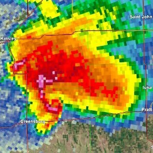
Rapid formation of a very large EF3 tornado 2 miles northeast of Greensburg Kansas around 10:05 PM on May 4, 2007. This tornado formed as the Greensburg EF5 was occluding and quickly grew to over 2 miles wide.


2
13
99
The 1999 Bridge Creek-Moore tornado reached an intensity that few other tornadoes have ever reached before. Definitely one of the most powerful tornadoes in modern history.


2
13
94
Chilling Special Weather Statement from NWS Norman as a deadly tornado outbreak began to unfold on May 24, 2011.
1
19
87
Tornado damage in Pembroke, Georgia after an intense tornado earlier! Large home swept completely away and several nearby trees heavily denuded/stripped. (Excuse the poor quality) Link to video:
7
35
81
Some screen grabs from
@theScantman
video, this is some classic violent tornado damage trees completely debarked and denuded, some sort of structure by the road also leveled as well. Awful situation in Andover, KS.


3
28
84
One of the largest tornadoes ever recorded at 2.2 miles wide tracks near Trousdale Kansas during the nighttime hours of May 4, 2007. This tornado, rated EF3, formed just minutes after the Greensburg EF5 dissipated and would track 23 miles over rural areas.


2
11
79
Video taken just moments before the devastating Joplin Missouri EF5 tornado decimates neighborhoods near Joplin High School on May 22, 2011. Fortunately this home was on the outer edge of the damage swath, sustaining only Low-end EF2 damage.
4
13
68
Video of the probable brief tornado, dust kicked up beneath rotation for about 30 seconds before it was rain wrapped.
6
19
69
In the midst of the Lockett TX tornado tonight, at this very moment 15 years ago today in 2007 Greensburg Kansas would be completely devastated by an EF5 tornado. This video below has some incredible aerial and ground images showing the extent of devastation to the city.
3
14
67
Very large tornado visible on traffic camera ~5 miles away in Gallatin TN! Tornado emergency in effect, damaging and significant tornado continues.


3
12
61
The Sunflower Electric Holcomb Station near Garden City KS recorded a 98mph wind gust around 12:30PM, good chance that’s the highest gust so far in Kansas today.

3
11
58
The May 24, 2011 Chickasha Oklahoma EF4 tornado caused some of the most extreme vehicle damage I’ve ever seen.


4
8
55
Video of a tornado sending tumbleweeds airborne south of Garden City, KS two days ago, may have been the same EF1 tornado that went through town. Filmed from the Southwind neighborhood looking East, DFA building is visible at left.
@NWSDodgeCity
Credit:
4
8
56
A massive EF3 tornado tracks near Plains, Kansas during the evening of November 16, 2015. This tornado reached a peak width of 1.1 miles and tracked 51 miles during its 1 hour and 18 minute existence.


3
10
48
Aerial photos of extreme damage from the last official EF5, the 2013 Moore Oklahoma tornado.


2
11
53
On April 27, 2011 the town of Smithville, MS was devastated by an extraordinarily powerful tornado. Houses and businesses quite literally exploded as the EF5 tornado moved through town at over 70mph, taking just seconds to produce some of the most extreme damage documented.


3
8
48
A massive wedge tornado tracks just 3 miles north of downtown Birmingham Alabama on April 27, 2011. This tornadoes visual appearance in the Birmingham area will never not be terrifying.


2
7
48
What EF5-level wipeout looks like in a densely populated urban area. The result of the 2013 Moore Oklahoma EF5 tornado, one of the strongest in modern history.


3
10
49


Extreme tornado damage throughout Greensburg Kansas after the 2007 EF5 tornado. Tree and vegetation damage ranks up there with some of the most violent recorded.


4
13
46


Rare photos of utter devastation in and around Greensburg, Kansas following an extremely violent tornado on May 4, 2007. Given the intensity and time of day in which the tornado struck (around 10 PM) it’s amazing that the number of fatalities and injuries wasn’t MUCH higher.


8
5
41
These are the 3 EF4 DI’s from Newnan GA. One one was completely obliterated yet a new Camaro was left unmoved and only sustained a few dents, which is remarkable considering the entire house was gone. This is still preliminary so more EF4 DI’s are possible.


3
8
41


May 25, 2016. On a day where the SPC initially issued a broad 2% tornado risk, nobody could’ve expected that on this day a massive EF4 tornado would track 25 miles across Northeast Kansas narrowly missing the town of Chapman by just 1 mile.


2
7
39
May 16, 2015 Elmer OK EF3 tornado. This mile wide wedge tracked 40 miles across rural Texas and Oklahoma. The tornado was likely capable of producing EF4+ damage though only EF3 damage was found to trees and outbuildings. Gate-to-Gate velocity on radar was over 250mph at times.


5
6
37
The long-track tornado that struck near Clarksville TX and Idabel OK on November 4th has now been officially rated EF4, the 3rd EF4 of the year and the first EF4 in Texas since April 29, 2017.


0
9
39
Definitely NOT my photo, but I think this is probably the only image of the May 23, 2008 Hopewell KS EF3 available on the internet.


Are there any tornadoes/storms that you believe you have the best/only picture of?
I was the only chaser who witnessed this storm at this point near Leon, Iowa on June 7th, 2022.

81
28
346
1
5
39
Before the Greensburg tornado on May 4, 2007 the last F5/EF5 tornado occurred 8 years and 1 day prior on May 3 1999. At the time that was the longest streak without an F5/EF5 tornado. Today marks 8 years and 1 day since the last EF5 on May 20, 2013.


1
11
38
Top tier violent tornado in Omaha suburbs. Just incredible.
0
9
39
Obviously the NWS and damage surveyors know best, but I’m being serious when I say this is some of the most extreme contextual damage I’ve seen in recent years.


2
5
37
This was where the tornado likely reached peak intensity based on radar, debris was lofted over 18,000 feet as it was passing through Woodridge and Darien Illinois. Praying for no injuries and fatalities.
#ilwx


0
16
35
If we are holding the EF5 rating standards to 2 of the powerful tornadoes in recent history, it’s going to be a very long time until the drought ends. This is likely still preliminary but if this is the final rating our standards are way too high.

8
8
35
This is plausible High-End EF4-EF5 damage if this home was well built, entire house swept away, ground scouring and evident tree debarking, and clear wind-rowing. Classic violent tornado damage.


4
11
35
Rare images of EF5 damage from the Greensburg tornado south of town near South Main Street and East Scott Avenue. A field south of Scott Avenue was scoured significantly and aerial images show intense wind-rowing of debris indicative of exceptional intensity.


3
4
31
Benton Kentucky, a town of about 5,000 people is sustaining a near direct hit from a violent tornado right now, this will be an event that will be remembered for several decades.


1
10
34
@hurricanetrack
This is the most gut wrenching weather video I’ve ever seen. Knowing that 150 people stayed is horrific. Do you recall how high the camera was off the ground?
2
0
32
On May 23, 2008 during a prolific tornado outbreak in Kansas, a lesser known nighttime tornado would touch down in Pratt County. Near Cairo this tornado reached EF3 strength as it lofted a car 567 yards through the air, killing a couple inside and debarking nearby trees.


5
3
31
The formation of the May 3, 1999 Bridge Creek-Moore F5 tornado. It quickly grew to 3/4 mile wide in a little under a minute after touching down and rapidly intensified.
3
4
30
@WxStelten
I think the rating raises more concern from an engineering standpoint that the structures were that poorly built it couldn’t be rated higher. But at the same time from a scientific point there is no denying this tornado was certainly violent.
2
1
31
May 9, 2006 Westminster TX F3 tornado. This likely violent tornado completely swept away several homes and scoured the ground deeply. Several cars were thrown hundreds of yards and mangled beyond recognition, some of which were wrapped around debarked trees.


4
4
31
On May 23, 2008 a massive tornado would touch down in rural Clark County KS. Near the Clark/Kiowa County line it would grow to 1.8 miles wide and achieve EF3 strength as several trees were debarked and an oil tank battery was thrown nearly 2 miles.


2
3
28
@WxZachary
By far December 10, 2021. Such a historic event that for the first time since tracking weather left me truly shaken for several days on end and still boggles my mind. Watching those two EF4’s wipe out town after town with seemingly no end in real time still sticks with me.


2
1
27
This is the same tornado that probably just wiped out the village of Whitman Nebraska, again while completely unwarned. Hopefully everyone in the area took appropriate shelter.


2
5
26
At least 4 towns last night were hit by last nights historic and violent tornado, could very well see EF4+ damage in all 4 areas. Very tragic to hear loss of life as a result from this tornado. There’s a good chance yesterday will be remembered for a long time.


1
9
25
@Bennett_rhodes5
Woah that tornado was so powerful it turned Maryland into Montana! Shiver me timbers I’m shakin in me boots.
1
0
27
Video of the 2011 Tuscaloosa-Birmingham tornado as it was inflicting near-EF5 damage to the Chastain Manor Apartments near Alberta Heights.
2
5
24
Every indication is there for a very high-end tornado with incredible intensity, just a matter of construction quality that will permit the rating. This is personally the most complete wipeout I’ve seen since Mayfield/Dawson Springs.
Screengrabs from:

1
0
26
Video of the tornado in New Orleans 2 days ago, glad he’s ok but 💀😭
0
5
24
I put the path of the May 4, 2007 Trousdale tornado into google earth. The tornado reached its peak width of 2.2 miles along U Road and 250th Avenue 2 1/2 miles southwest of Trousdale. Trees still have debris entangled between them and an old farmstead was never rebuilt.


2
3
23
8 years ago on this day in 2014, an extremely violent and controversial tornado obliterated sections of Mayflower and Vilonia Arkansas resulting in 16 fatalities. Numerous homes and businesses were completely destroyed and swept away, some of which were well constructed.


2
5
24
Greensburg KS EF5 May 4 2007
This massive and very intense tornado completely obliterated entire sections of Greensburg destroying 95% of the town. Trees were completely debarked, and numerous businesses and homes were devastated. First tornado to be rated EF5 on the new scale.


1
3
22
Extreme damage following the devastating Moore Oklahoma EF5 tornado on May 20, 2013. So much soil was scoured away that every thing left standing was plastered in mud. Likely among the most intense tornadoes in modern history.


2
4
24
@sorrowen
Many of those homes just flat out disintegrated. I also can make out several instances where even the stem walls of the foundation gave way and collapsed. Vegetation and vehicle damage is a good indicator to just how violent this storm was, comparable to past high-end events.
1
1
23
A massive nighttime tornado tracks northeast of Greensburg Kansas on May 23, 2008. This likely violent tornado would grow to over a mile wide and inflict EF3 damage near Hopewell and Macksville, debarking trees and destroying several farms.


2
3
24
On May 25, 2016 an incredibly intense EF4 tornado would track 26 miles across rural northeast Kansas. The small town of Chapman had been in the direct path of this monster but was spared as the tornado jogged just to the south. This tornado very likely had winds in the EF5 range.


1
1
22
Canton Lake OK EF3 tornado May 24 2011. This 1/2 mile wedge completely debarked trees and flattened several homes at borderline EF4 strength. Ground scouring occurred and several vehicles were thrown and mangled. The tornado had very intense motion and appeared to be violent.


2
7
21
Incredible damage in the Eastlake Estates neighborhood in South Oklahoma City following an F5 tornado on May 3, 1999.


0
2
20
After exiting the Tuscaloosa-Holt Alabama area the Tuscaloosa EF4 tornado completely swept away a well-constructed brick home near the community of Peterson. Trees nearby were completely mowed down and partially debarked and a vehicle from the residence was thrown in a ravine.


1
1
21
Washington IL EF4 tornado November 17 2013. This High-End EF4 cost nearly $1 Billion dollars as it devastated Washington. Entire neighborhoods were leveled and several well built homes were swept away. Trees were debarked, and ground scouring occurred as well.


1
2
19
For those that are wondering, the town that you see is Moore Oklahoma. This tornado occurred on May 20, 2013 and was the 2nd F5/EF5 to strike the city in 14 years.
1
2
22
One of the more underrated tornadoes that occurred during the May 3 1999 tornado outbreak was the Dover OK F4. This 1/2 mile wide wedge caused devastating damage across the northern sections of town, leveling homes, debarking trees, and deeply scouring the ground in some areas.


2
3
19
Saw this tier list going around, decided to rank violent tornadoes from 1971-present. Mainly considered contextual damage among other things.

10
3
22
The remains of a two story farm home that was violently swept away by an F4 tornado in Dover, Oklahoma on May 3, 1999.


0
2
18
Very clear cut violent EF4+ damage in Bremen KY, this damage is quite impressive considering Mayfield is over 90 miles from Bremen and the tornado likely maintained violent intensity that entire time. Absolutely incredible.

Cant find a source for this image of damage from Bremen, Kentucky but incredible damage. Some hallmarks of a very strong-violent tornado. Absolutely awful.

1
20
89
1
7
20
Catastrophic damage in Concord Alabama after the April 27, 2011 High-End EF4 tornado. This was the first suburb of Birmingham to be impacted by the Tuscaloosa tornado after it had exited the Tuscaloosa area and plowed through 30+ miles of rural forest.


0
5
21
@JackSillin
May 23, 2008 western Kansas tornado outbreak was another great example of this. Basically every single significant tornado that occurred that day turned left at the end of their lifecycle.

0
2
19
All that remains of the Greensburg Mennonite Church after the EF5 tornado on May 4, 2007. Note the extreme vegetation damage nearby as well. The brick church was leveled entirely and nearly swept away by the tornado and all trees including shrubs were completely debarked.


1
2
19
Violent tornado tossing massive amounts of debris in the air in Chester Illinois, debris ball on CC IS NEARLY 3 MILES ACROSS!

0
4
19
At this time 10 years ago a mile wide EF5 tornado would begin tearing through Joplin Missouri. Entire sections of the city were completely devastated and numerous homes and business were flattened. 161 innocent lives were lost and damages exceeded $3 Billion.


4
3
18
Extreme damage following a High-end EF4 tornado that devastated areas in and around Pilger Nebraska on this day in 2014. This tornado as well as the Stanton and Pilger East EF4 tornadoes that same day all likely reached EF5 intensity at some point.


0
2
18
A brick farmhouse that was swept completely off its foundation and a shelterbelt completely denuded and debarked by a 2.2 mile wide EF3 tornado near Trousdale, KS on May 4, 2007.


2
2
18
Anyone heard from Reed Timmer recently? Noticed he hasn’t posted on any social media in a while and the area he was located was getting absolutely hammered. Hope everything is alright.
4
3
19
This makes the first time since April 27, 2011 that there have been 2+ tornadoes that tracked 100+ miles in one day. The Mayfield KY tornado is the longest tracking tornado in modern history surpassing Yazoo City MS, and is one of the longest tornado paths in history.
0
3
18
Video of the tornado directly over the town of Smithville, for context the downtown area is about a mile beyond the tree line on the right. Considering it’s forward speed which was between 70-75mph, it’s likely the most intense damage occurred in just under 3 seconds.
1
3
18
Trousdale KS High-End EF3 May 4 2007. This enormous tornado quickly grew to 2.2 miles wide(possibly even wider) as it swept away a farm house, debarked trees, and tossed a combine 1/4 mile. Tornado was very likely significantly stronger than EF3 but impacted rural areas.


2
0
15
28 people were reported to still be in Grand Isle Louisiana as Hurricane Ida made landfall, including the police chief that had a phone interview with the weather channel. The weather channel is reporting now that they have lost contact with the police chief.

1
8
18
The violent Hopewell tornado on May 4, 2007. On the Giles’ farm a fatality occurred as a home was ripped off its foundation and 2 nearby trees were thrown into the basement. A blazer was thrown 3/4 mile, trees were entirely debarked, and another well built home was swept away.


1
2
17
The remains of Greensburg High School after the EF5 tornado. The 3 story school had its entire upper floor removed, and the south wing of the building which was very well constructed with triple-thick masonry walls, was completely leveled and partially swept away.


1
6
17

one of these days I’ll finally get 300 lol just not today

2
0
17
On May 24, 2011 a violent tornado would touch down in Grady County Oklahoma. This extremely violent EF4 swept away several anchor bolted homes, scoured pavement and grass, and tossed vehicles over 600 yards. No doubt it likely reached EF5 intensity at some point.


0
1
15
A significant-violent tornado may have just dealt a direct hit to the village of Whitman Nebraska, while unwarned. Noticeable CC deepening indicative of more debris being lofted in the air while in the village vicinity, likely massive damage to these poorly built structures.


1
6
16