
WxNate
@weatherffolkes
Followers
1,871
Following
793
Media
3,037
Statuses
45,767
Natural phenomena enthusiast with a special (but probably odd) interest in hurricanes God is an artist🎨. Earth is His masterpiece🌎.
Kingston, Jamaica
Joined May 2020
Don't wanna be here?
Send us removal request.
Explore trending content on Musk Viewer
#RBSJackRusselXBuild
• 164430 Tweets
Build Wearing Denim
• 163123 Tweets
#KAMIGATA_BOYZ
• 97319 Tweets
オールカマー
• 44138 Tweets
神戸新聞杯
• 43983 Tweets
イタリア
• 43586 Tweets
アニエラ
• 29371 Tweets
あんスタ
• 27861 Tweets
ジャック
• 27072 Tweets
NASA NORTE SI OLBAP
• 25477 Tweets
To the Edge
• 25164 Tweets
メイショウタバル
• 21574 Tweets
Vol.5
• 21326 Tweets
キサキ実装
• 18603 Tweets
レーベンスティール
• 18474 Tweets
#Coldplay
• 17380 Tweets
#BookMyShow
• 16272 Tweets
殺傷事件
• 15902 Tweets
ぱしゃっつ
• 14546 Tweets
ラジオ体操
• 12512 Tweets
P.A.shots
• 10883 Tweets
マジック1
• 10198 Tweets


Pinned Tweet

Here is the updated forecast for peak hurricane season. Once again, a bit lengthy, but it has graphics this time😂! Skip to pages 7-9 if you don't desire to delve into the🤓stuff. Not too much of a change from the initial forecast, still quite daunting.

1
1
6
This might be the most insane Euro run I've ever witnessed, at least on this side of the world. I'd love to see the upper-level pattern on this when the main model runs in another hour or so.

21
37
395
@wintergirl_93
@Breaking911
@SpiritAirlines
the child is eating anyway, how on Earth would a mask even work at that point smh
4
4
329
3
1
311
This honestly might be the most "that look" storm I've ever tracked...at least since Iota went full🍤
#Debby
21
34
293
@jespersny
@loafingcactus
@SeewehM
@CBSNews
@mashiane05
there are six S African countries there without confirmed Omicron cases yet their people are banned from the US
3
2
237
@lee_3143
@cringepicture
the cringe is in the fact that she actually tweeted about it and somewhat disrespected the site itself...more of disrespect true but still somewhat cringe
1
1
189
18
1
168
@ImLiteralLarry1
@JefftheSpursfan
@downbadpatrol
i actually needed help understanding this...this is yours Larry👑
3
0
172
0
0
133
@SNE2471
@BarcaUniversal
Lol I was thinking this too but technically your body can be awake with your eyes still closed...you can regain regular consciousness of your surroundings except if you keep your eyes closed, you'd just bounce into stuff😂
1
1
145
1
0
115
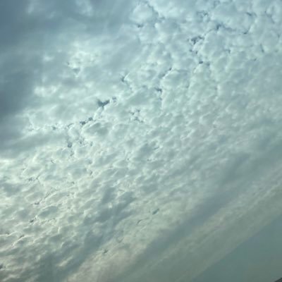
I will never understand how anyone finds the tropics uninteresting. These are not even a full 24 hours apart, incredible what clouds can do...


2
26
130
@PolinaVol95
@emilesmithjoe
@Brickmeer
Well obviously not, they just said he's nominated because it's a list of 30
0
0
119
#Bret
is exhibiting signs of a storm preparing for possible rapid intensification. Recent frames showed primary VHTs that seemed to have formed a nascent CDO, and possibly a inner core. Another hot tower has also fired within the core, indicating that this is maturing quickly.
12
14
123

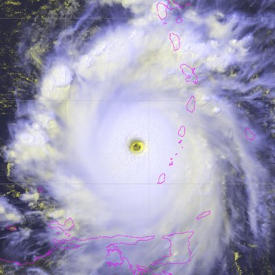
#Beryl
is symmetrizing, and mesovortices have coalesced to form a pinwheel pattern in the increasingly clear eye. This is typically only seen in high-end storms, and clearly this storm is striving to join that group. The fuel for this storm is extraordinary in every sense.
3
20
111
The last time the Super Bowl went into overtime was 2017. That game also featured a comeback.
The last US total solar eclipse was in 2017, in a month starting with 'A'. There will be a total solar eclipse in the US this year in a month starting with 'A'.
Ready up Atlantic🌀


10
20
107
For the first time in history, every major worldwide basin has produced a Cat 5 in the same year:
NAtl:
#Lee
EPac: Jova
WPac: Mawar
NIO: Mocha
SPac: Kevin
SWIO: Freddy
AUS: Ilsa
2023 has been PEAK tropics🌀
4
18
98
This is an absolutely ludicrous convective burst near
#Franklin
's LLC. Temps in the overshooting top around 15N/68W seem to be breaking the scale and tanking below -90C, possibly unheard of in the ECar. Only question is if this is actually helping or if it's like Elsa near Haiti.
3
9
95
Can someone turn this thing off? Someone please remind
#Beryl
that the calendar still says June...
6
8
98
@alliiioooo
@manu_addai
@MagicalArthur_
@ESPNFC
but Juve plays like crap in the UCL every season, he might actually have a point
1
0
67
Oh ok then...
What stands out for me is not even the solutions towards the end, but how great the agreement is between 50-65W, especially this early in the season

3
13
80

1
0
69
2
0
75
0
0
73

@Simen63551540
@BafetembiSayeed
@CSkian000
@fcbmessifc10
@ESPNFC
It means they're likely not getting relegated bozo
1
0
60
After struggling heavily this morning,
#Bret
once again looks impressive. Outflow seems to be expanding radially, and the new CDO seems to be becoming better aligned with the LLC. Some fairly robust rotation in the center begs the question of what is happening in the mid-levels.
4
9
73
Seems like
#Franklin
is undergoing a center reformation, with a strong MLC evident around 14N/69W between the strong convective bursts in the system. ASCAT from earlier this morning also showed new rotation around the same area, shifting from its initial position out west.
3
4
72


I don't want to sound insensitive, but this "hype" about
#98L
's possible long term impacts to the US is overshadowing its medium-term impacts in the Caribbean. Many are talking about what this could do to FL, TX, etc while Cuba, Cayman Is, or the YucaPen could be at risk first.
11
9
69
Bro fought so hard and even pulled up with its own gravity waves in the face of high shear to impress NHC and get a name😂
#Gert

Have to wonder if the primary cause of strong wind shear with 06L being the screaming winds at 200mb is why the system has been able to hang on in the face of nearly 45 knots of wind shear...


6
0
30
6
2
69
@Dreckson_
@brfootball
no shame whatsoever...and if this isn't ratio'd it's bcos ur comment was so dumb no one cares to respond to such madness
0
0
61
@Offishial_mayor
@Akhiff1
@UTD_Samy
@fcbmessifc10
@brfootball
if u don't know Pedri, ur either a Barca hater or plain retarded
1
0
60
This is an impressive CB rising from the western edge of
#95L
. These convective bursts that occur at sunset are often an indication that a system is closing in on TCG, or ready to start a period of gradual strengthening having matured enough to withstand the diurnal cycle better.
0
4
67
Ain't no way we boutta do this again...
#Franklin
This is an absolutely ludicrous convective burst near
#Franklin
's LLC. Temps in the overshooting top around 15N/68W seem to be breaking the scale and tanking below -90C, possibly unheard of in the ECar. Only question is if this is actually helping or if it's like Elsa near Haiti.
3
9
95
8
6
66
On this day many years ago, after re-emerging over the Caribbean Sea following its landfall in Jamaica, Hurricane Gilbert rapidly intensified and rapidly deepened into the greatest storm witnessed in the Atlantic basin🌀


5
6
65
@alliiioooo
@manu_addai
@MagicalArthur_
@ESPNFC
true but just bcos they beat them in December doesn't rlly mean they're better now...we'll see
1
0
49
This is one of the few Atlantic hurricanes that ACTUALLY looks like it came straight out of the WPac...
Because really and truly, the Atlantic is playing mini WPac right now🚀
#Beryl
Evidence of the ferocity of this storm in real-time: the eye has warmed to 10C with the eye still not fully cleared, having been around -10C just *half-an-hour ago. Truly remarkable this...
0
1
18
2
2
66
Late to the party (as usual) but it really is utterly insane how CanSIPS continues to find a way to paint the Atlantic more favourable every month. Early season really captivates my interest because there seems to be some strong signal for potential activity from the very get-go.


2
7
66
This is an exceptional microwave presentation of
#Lee
within the last hour, and you can easily make out this same shape on satellite imagery. Honestly think this is solidly a Cat 4 now, and recon could be sampling an absolute machine tonight should this continue.


3
3
63

Microwave imagery from over 4 hours ago indicates that
#95L
already has a fairly impressive low-level structure, and convection associated with the LLC has continued to sprout ever since. Wouldn't be surprised to see a TC in the next 36-48 hrs given a generally conducive envt.


2
9
62
If anyone said in April that the first NHem major this year would be out of the Atlantic, the backlash would've been crazy.
#Beryl
continues to tumble record after record, and it seems that it might even attempt to be the first ever June Cat 4. It has less than 12 hours to try.
6
3
62

This is definitely one of the best storms we will track all year...ridiculous longevity from
#Sam
1
5
61
2020 and 2021:
Both had A named storms in the subtropics in May
Both had B named storms on the Eastern Seaboard
Both had C named storms that hit LA
Both reached D by June
Both had storms that formed quickly and hit SC
10
12
57
1
0
53
Thinking about making a winter group...first 25 true winter fans to reply will be added. Only co-operative people and those willing to teach or learn will be kept.

27
2
56
0
0
55
Red X in a yellow hatch looks so weird😂we're gonna be dealing with more monsoonal trouble for another week with the new AOI

2
3
59
Throwback to when GFS turned Irma into the Labour Day Hurricane...

4
3
57

#Ian
has continued to organized overnight and is now the 4th hurricane of the season (all this month!) Its presentation is pretty remarkable - rarely does a storm portray a shrimp in its whole structure, as well as in its CDO. Really doesn't seem long before the coop is flown.


1
11
56
1
0
50
#Ernesto
has continued to organize throughout today, although it does currently portray a funny dual-blob presentation. Outflow is already pretty great and will continue to improve. Also of note is a "sunset spike", typically the precursor to a nascent CDO and possible RI.
2
3
58
It may not seem like it, but the Atlantic may be ready to lift the cap off very soon. This is the first infographic I'm doing in a while (probably since 2021), just sharing some general thoughts on the different features to watch in the basin. Future IGs should be more detailed.

4
6
57


It has begun...⛈️
A surface trough is beginning to develop in the WCar in association with the strengthening upper trough overhead. The ULL and surface low are both expected to amplify, bringing severe weather to the Greater Antilles, as well as the Turks and Caicos Islands throughout this week.
3
6
43
2
5
55
#Bret
is like that street baller that starts playing crappy when the scouts come to town...worst possible time to be looking this good, right after recon left🤦♂️
5
5
57
#Otis
has today done what can only be described as phenomenally unprecedented. Having not been forecasted to be a hurricane even 24 hours, the storm managed to rapidly become a mid-grade Cat 4, at a rate that outmatches even Patricia(!), which dissipated OTD 8 years ago.
2
5
57
#98L
has consolidated a good bit throughout today. A well-defined surface low does not yet exist, but an MLC is evident within the circulation around 38-39W. Dmax will likely build upon the stratiform foundation of the invest as it approaches slightly warmer waters.
2
5
55
Seems like
#TD7
is relocating its center, with its circulation looking stretched from clearer air to the deeper convection. Max vectors seem to be about 45 kt, but they could be rain-inflated so I'd guess 40 kt miiight be a safe guess. We'll see what NHC does.

3
1
55
Ye um this cannot be 45 kt in any way, shape or form.
#Don
has successfully wrapped convection upshear, with its eye evident, all under expanding radial outflow and slight jet interaction. If it was 45 kt with a half-core, how can it still be 45 kt now?
8
2
54
This is an honestly mental satellite loop. We always talk about how Lenny's track was weird, but very few of us actually get to see its movement. Looking at this, it seems absolutely unreal; you'd think it was reversed if it wasn't for the obvious structural improvement.

3
6
51

#Franklin
genuinely cannot get any more impressive. As night falls upon this impeccable system, you can see a core structure that is sustaining remarkably, possibly even more so as its poleward outflow opens up again. Recon is about to answer all our questions in a little bit.
3
7
54
#Emily
1987, 2005, and 2023
18-year gaps...the downfall is crazy
Looks like retirement will have to wait even longer


4
6
53