

Tom Bike
@tom_bike
Followers
4,225
Following
251
Media
10,166
Statuses
35,089
Satellite Images 🛰️📷 My tearless retina takes pictures that can prove 🚵♂️ MTB
São José dos Campos, Brasil
Joined February 2010
Don't wanna be here?
Send us removal request.
Explore trending content on Musk Viewer
SEVENTEEN
• 881939 Tweets
Netanyahu
• 799938 Tweets
Olympics
• 444658 Tweets
オールスター
• 232979 Tweets
#Paris2024
• 202704 Tweets
CENTURY OF LOVE EP5
• 158581 Tweets
土用の丑の日
• 154422 Tweets
Axios
• 98660 Tweets
#우리의_여름하늘_하오의_날
• 95152 Tweets
デッドプール
• 81836 Tweets
ウルヴァリン
• 66703 Tweets
Marruecos
• 63017 Tweets
Wray
• 59867 Tweets
Manchester Airport
• 57493 Tweets
CROWN PRINCE ZHANG HAO DAY
• 54733 Tweets
Colored
• 51347 Tweets
Medina
• 44293 Tweets
オースティン
• 39623 Tweets
#JO1ANNX
• 36256 Tweets
Mascherano
• 36024 Tweets
最低賃金
• 32575 Tweets
Maroc
• 26336 Tweets
Morocco
• 25859 Tweets
Nadler
• 22270 Tweets
#道枝駿佑誕生祭2024
• 14643 Tweets
Marroquíes
• 14004 Tweets
Bowman
• 13918 Tweets
Kilmeade
• 12372 Tweets
Skibidi Toilet
• 12019 Tweets
THE FINAL DREAM OF US
• 11303 Tweets
Uzbekistán
• 10893 Tweets
Bob Dylan
• 10099 Tweets


New Sevastopol dry dock higher resolution satellite image shows heavy damage on both ships hit; Ropucha landing ship and Kilo submarine.
#Sebastopol


26
155
619
Another Gaza Trident pier defense layer spotted. US Army C-RAM on a semi trailer can be seen at video below.
FAAD C2, Counter Mortar & Firefinder RADARs, K-band Radio Frequency System, feeding Air and Missile Defense Workstation controling a 20mm Gatling gun.
#IsraelHamasWar


The floating pier that the US military built to provide aid to the Gaza Strip.
36
57
271
16
145
403

Storm Shadow missiles HIT CONFIRMED at 🇷🇺Russia´s military RADAR in Ai-Petri Crimean Astrophysical Observatory. Civilian buildings are OK.
44.4849, 34.0304
YESTERDAY satellite image shows exposed soil around + scorch marks at concrete patio where system vehicles were.
#Crimea
Location of Ai-Petri Ай-Петрі
#Crimea
< Russia military radar complex attacked TODAY with
#StormShadow
missiles> in case someone wants to order a satellite image is
44.48102,34.03365
Satellite image below was shot 3 DAYS AGO 👇

1
11
30
6
59
330
Look what I´ve found! TODAY 3 vessels almost at Kazantip Bay. All same class, about 110 m long. Prob. those Russia Ropucha landing ships, now sailing Azov Sea safer waters. Wonder with what kind of cargo.
Bay beach is a kitespot, but I don´t think they are into kitesurfing...

11
54
320
Vuhledar and surrounding towns TODAY.
In black color scorched areas without snow due to fires or bombing. Note how smoke plumes leave soot marks in the snow following wind direction.
@ESA
´s
@CopernicusEU
Sentinel 2 satellite 10FEV2023 image at


Vuhledar overview 20230209
I believe AFU holds the blue areas while RuAF are trying o advance along the red arrows. Without success I might add.

5
29
535
1
62
298
Fábrica flutuante de açaí movida a energia solar está operando no Brasil. A idéia é chegar mais perto dos produtores extrativistas na selva.
É a balsa Açaí.


4
26
235
US Army M-LIDS spotted at Gaza
#JLOTS
pier.
< counter-drone electronic warfare system, FAAD C2, electro-optical infrared camera, direction-finding sensors, 30mm chain gun, KuRFS RADAR and Coyote Block 2 Interceptor mounted on a M-ATV>


The US-built floating pier on the coast of the central Gaza Strip, known as JLOTS, has begun operations.
The IDF says 310 pallets of humanitarian aid were brought into Gaza via the pier today.


38
88
325
8
86
220
All hell broke loose TODAY at Gaza. Israel made some serious war move. Hamas has been enveloped. Israeli troops advanced past port area.
08:31 UTC satellite image shows several urban battle/shelling related fires around and right at Shifa Hospital / Hamas HQ, expect collaterals.
11
32
203
Encontraram água em Marte! Usando dados de sensoriamento remoto RADAR que foram obtidos há 15 anos pelo instrumento MARSIS na
#MarsExpress
.
🛰️
Paper:
Para leigos:
#Marte
#Mars

1
42
186
Brasileiros publicando em revista científica de renome anonimamente. Nunca vi isso.
Parabéns a todos os envolvidos.

Brazilian researchers investigating the cause and extent of wildfires in the Amazon are so afraid for their jobs that they have published their findings in a leading journal anonymously, reports
@john_pickrell
for
@NatureIndex
.
18
618
1K
0
81
170
High resolution
@umbraspace
RADAR image analysis shows Russia moved S-400s from Kaliningrad.
Nice
#remotesensing
work building on
@auonsson
find using ADSB exchange data showing sudden increase in Russian military cargo flights.


21
45
156
Incêndio em Barueri com tanta fumaça preta que dá para ver do espaço!
Satélite GOES 16 hoje, última imagem 13:20 local.
2
31
147


O Lago de Tefé "secou"!
Note grande banco de areia no Rio Amazonas e estreitamento do canal em São Francisco do Piranhal, em cima à direita.
Imagens de satélite de ONTEM e de 20 dias atrás. Verdade de campo, fotos de
@margemdorio
no RT.
h/t
@helenapquist
@YRS_PA
#ClimateCrisis

Acabei de fazer esses registros. “Não sobrará água”. O rio Solimões virou um igarapé. A seca tá foda esse ano, o norte como sempre se lascando, com escassez hídrica, falta de abastecimento de produtos na cidade, e o que é televisionado: o sofrimento do sudestino com calor.


23
991
3K
2
71
131
YESTERDAY satellite image of MV ROY P. BENAVIDEZ, formerly a Navy supply ship, loading up modular causeway pieces to build Gaza´s American pier and 2 miles offshore floating dock. Army-led deployment of joint logistics over-the-shore
#JLOTS
.
36.9727, -76.4341
#IsraelHamasWar


U.S. Still Developing Gaza Pier Details as Crew Work to Prepare Components - USNI News

12
23
47
12
29
121
Ropucha that was hit and exploded at Feodosia started docking there in September.

Whatever ship is cooking off at the main pier at Feodosia is seen on Sentinel-2 L2A on December 24th (the day prior).
Large secondary blast would indicate ordinance of some kind.

20
87
554
2
18
123
@DefMon3
@ArtisanalAPT
@NLwartracker
@COUPSURE
NNIIRT Nebo SVU Ural 4320 tractor towed semi-trailer
satellite subset image annotated validating my interpretation < proof :) > over Miroslav Gyűrösi pic at
h/t
@bykallan
who IDed it here

5
8
117
Fires TODAY SW of Robotyne near Chystopillia. Smaller one exactly over Russian defensive line.
True color and SWIR Sentinel 2 satellite image.
Will not speculate what they are and let it to the PROs.
#ukrainecounteroffensive

4
7
119


Claramente visível a onda de choque da erupção do vulcão em Tonga, com direito a tsunami, avançando em frente à pluma de cinzas vulcânica.
Imagens do satélite Himawari 8.
4
10
113
Whatever happened 2 days ago in Kreminna Forest at 48.98991,38.05558 <1st pic>, well, in brief it was really bad. I´ve never seen this kind of fire heat pattern.
Based on control maps looks like a Russian incursion into Ukranian turf gone bad.
Combat related fires all over.


5
12
111
TODAY´s SWIR satellite image of Russia´s S-400 battery N of Olenivka, Crimea, hit yesterday by Ukrainian R-360 Neptune cruise missile <s?>.
45.415810, 32.534960
Arrows at most probable fire starting points.

Earlier today, Ukrainian forces managed to successfully hit a Russian S-400 battery based outside of Olenivka, Crimea, destroying at least one TEL.
77
703
9K
3
10
103
Despite clouds I was able to spot TODAY 5 cargo carrier ships sailing Black Sea´s Ukrainian Humanitarian Corridor.
Since August those vessels delivered grain and other goods from Ukraine to 24 countries.
Lenghts from left to right: 108, 170, 155, 194 and 230 meters.
#UkriCor

8
15
102
New Kerch bridge satellite image detailing defenses construction works.
Intrigues me most what is going on N of Crimea bridge. See on inset pillars being installed on the seabed. Russia have done it already temporarilly when it went boom, but it was closer to bridge.
Thoughts?


12
22
104
Essa imagem falsa cor do Lago Tefé permite entender melhor a hecatombe dos botos.
Água clara aparece em cor preta na imagem na cheia. Água barrenta em verde claro e escuro. Praias de areia e nuvens em branco. Fundo do lago exposto em marrom claro. Em cima à dir. o Rio Amazonas.
4
33
102
Al Hudaydah Airport TODAY´s satellite image.
Near Red Sea just S of town it was already beaten & looking abandoned. Most hangars still standing are now gone.
Two scorched spots are prob where drone launching vehicles were hit.
#operationprosperityguardian
#Houthis
#shipping

Evidence of US🇺🇸/UK🇬🇧 strikes at Hodeida Airport, Yemen (14.76452° N, 42.98823° E)
Satellite Imagery via
@planet
11 January 12 January


26
80
342
9
36
100
TODAY atypical vessel agglomeration spotted 2.5 km offshore Crimea´s Cape Chersonesus near Sevastopol.
One in the middle, 50 m lenght, is smoking.
Also, busy port entrance plus patrol vessel iddle 1 km offshore.
h/t
@MT_Anderson
who noticed them.


10
14
99
"Maior desmatamento contínuo já registrado na Amazônia"..."aconteceu em 4 meses de 2020 (de fevereiro a maio)"
-7.850424, -54.972807
Animação de imagens do satélite Sentinel 2
@CopernicusEU
@sentinel_hub
.
antes 09/09/2019
depois 23/09/2020
processadas por mim h/t
@nandawenzel

"Se você não quer vender a terra, tudo bem. A viúva vende mais barato".
É o que costumam ouvir os proprietários que se opõem aos grandes fazendeiros na região da Amazônia. O destino das terras: garimpo ou pecuária.

6
444
1K
2
33
95

4
8
90


VYSSOS cargo ship TODAY after being hit by a mine.
Satellite image shows her at anchor & a boat at her side at 45.328830, 29.784900
1 km2 oil slick is visible in black color evidencing oil spill < bunker?>. Oil also at island where she did rest for a while
#UkriCor
#BlackSea


#BlackSeaIncidents
🇺🇦🚢
#UkriCor
There was a powerful explosion, the ship's stern was lifted off water and all machinery went off. The Captain's decision to steer towards the nearby breakwater and ground the ship prevented it from sinking.👇
2
6
23
3
29
87

Heading fast to the Red Sea, 90 km from Bab-el-Mandeb Strait we see Italy´s patrol boat on steroids ITS FRANCESCO MOROSINI P-431 🇮🇹 YESTERDAY.
Long-range missile frigate with land attack capability.
12.15171,44.01781
#IsraelHamasWar
#shipping
#OperationProsperityGuardian


5
18
88
Hey babe, did you see the American convoy TODAY?
Feliz Natal! :)


8
11
87
Looks like they are leaving this tree line defensive position. Just out of Novoprokopivka.
47.408400, 35.860030

Russians running away form their lines outside of and towards
#Novoprokopivka
.
#OSINT
#UkraineRussiaWar
️
#UkraineWar
#Ukraine
#Counteroffensive
#PutinIsNotRussia
11
54
452
2
3
88
Boat smoking YESTERDAY and another going nuts.
This incident and that on RT are unrelated to last night IVANOVETS sinking according to
@DI_Ukraine
timing.
#BlackSea
#Crimea

TODAY atypical vessel agglomeration spotted 2.5 km offshore Crimea´s Cape Chersonesus near Sevastopol.
One in the middle, 50 m lenght, is smoking.
Also, busy port entrance plus patrol vessel iddle 1 km offshore.
h/t
@MT_Anderson
who noticed them.
10
14
99
13
18
85

@MT_Anderson
I spotted these 4 leaving Novorossiysk to Sevastopol TODAY.
3 have about 100 m, one 130 m
44.69226, 36.75429
#Sentinel2
at

1
12
83


@CovertShores
@COUPSURE
@bradyafr
@NavyLookout
@oryxspioenkop
@UAWeapons
@OSINT88
@DaveGOwen
@SubBrief
@UKDefJournal
@hoje_no
@CorporalFrisk
Aqua satellite got it smoking.

2
11
73

TODAY´s Kerch bridge satellite image.
Defenses construction continues at a rapid pace.
17 barges + 2 docks at southern main span, crossing Kerch–Yenikale Canal. Progress also at Tuzla spit span dock and temporary bridge (details on RT, please also see comments there).
#Crimea

New Kerch bridge satellite image detailing defenses construction works.
Intrigues me most what is going on N of Crimea bridge. See on inset pillars being installed on the seabed. Russia have done it already temporarilly when it went boom, but it was closer to bridge.
Thoughts?
12
22
104
11
26
76

Robotyne situation annotated on TODAY´s satellite image. "Russia ... recaptured town pushing Ukrainians forces to trenches N of town."
Trenches at red dotted lines, nearest is only 500 m from blue red circle marking flag position at 47.4515,35.8284.
#Zaporizhzhia


Russian 71st Guards Motorized Rifle Regiment have raised the Russian flag in the Northwestern portion of Robotyne IVO 47.451466,35.828422.
Russian forces have likely recaptured the town pushing Ukrainians forces to the trenches north of the town.

2
23
64
3
16
72
Vazante extrema do Rio Amazonas em Tefé em imagem do satélite Brasileiro Amazonia-1.
Em marrom escuro superfície da água, em marrom claro e bege, fundo do rio exposto. Floresta em verde escuro, desmatamento em verde claro e marrom.
Note como o rio estreitou embaixo à direita.

O Lago de Tefé "secou"!
Note grande banco de areia no Rio Amazonas e estreitamento do canal em São Francisco do Piranhal, em cima à direita.
Imagens de satélite de ONTEM e de 20 dias atrás. Verdade de campo, fotos de
@margemdorio
no RT.
h/t
@helenapquist
@YRS_PA
#ClimateCrisis
2
71
131
1
27
73
Ocheretyne situation TODAY, several combat related fires indicatating Russian positions being hit hard south of railroad embankment.
"Russians advance in Ocheretyne southern area, Bradley neutralizing Russian infantry" reports
@Majakovsk73
.


1\
#Ucraina
Fronte di Donetsk: Russi avanzano nella zona sud di Ocheretyne, bradley in azione di contrasto su fanteria russa

8
36
255
3
7
71
"Incêndios" florestais: Amazonia Legal registrou maior emissão de poluentes atmosféricos em 20 anos em 2022.
fonte:
@CopernicusEU
em
#queimadas
#meioambiente
0
28
66
Literal tank highway was set by Israel from the border all the way to the beach to enter in force and allow Hamas troops envelopment/neutralization in central Gaza city yesterday.
"Road" is 33 meters ( 108 ft) wide at its first section on Juhor ad-Dik ( جحر الديك) fields.
2
11
66
Porto Alegre, Canoas, São Leopoldo e Eldorado do Sul HOJE.
Escala das inundações é impressionante na imagem de satélite. 🧵
#RioGrandedoSul


2
16
69
My poss. geolocation of Russian S-500 Prometheus ADS near Dzhankoi base is
45.686, 34.422
Based on Sentinel 2 historic images traffic evidence & NOAA-20 heat source detection pixel size, 410 x 450 meters plus < 1 pix RMSE.
Annotated on 4 days old satellite image.
#Crimea

Newest Russian S-500 intercepts (literally) ATACMS cluster missiles
Source: Tivaz Artillery "The ATACMS cassette (cluster Warhead) has arrived on Ebal Radar from S-500."
(Possibly the 76T6/77T6 ABM Engagement Active Phased Array Rada used for tracking high-speed ballistic


30
239
2K
4
17
69
Atenção Manaus.
Imagens de satélite de HOJE das imensas plumas de fumaça que se acumulam e aumentam alimentadas por diversos incêndios florestais e queimadas descontroladas na região.
1
31
64
Visão geral da inundação no Rio Grande do Sul HOJE. 🌊 Nível AGORA do Guaíba no Cais Mauá é 4,90m.
Grande mancha de sedimentos em cor marrom alaranjado lentamente toma conta da Lagoa dos Patos.
Anotadas na imagem de satélite Canoas, Porto Alegre, Pelotas e Rio Grande.

2
11
67
Busy monday TODAY offshore Gaza. Floating structure takes shape, 230x197 ft now beside USNS BENAVIDEZ; 10.5 km from beach.
Prob. trident pier tip that will be connected to causeway reaching beach, not large ship floating dock.
USAVs + Israel patrol boat nearby.
#israelhamaswar

7
25
65

@NLwartracker
nice IDing
Kasta-2E2 Low-altitude all-round surveillance standby conditions 3D RADAR for "low- and extremely low-level and stealthy air targets, in a heavy clutter environment" specs and brief description at

1
4
64
Russia´s Ocheretyne salient TODAY´s satellite image.
Several fires indicate intense combat / shelling on both sides. Positions, trenches, treelines, vehicles on fire after being hit.
Blue line = end of Ukraine control; white on
@Majakovsk73
map.
#Donetsk
#Novooleksandrivka

3
10
62


Kerch bridge anti sea drone barriers TODAY.
Work looks to have stopped, no vessels around. Note at Brad´s higher resolution satellite image subset that most of what we see is submerged, only a small segment is made of large floating booms. Prob. under construction yet.
#Crimea


Russia installed more barriers along the Crimean Bridge to counter Ukrainian naval drones, recent satellite imagery shows.

32
149
398
2
16
60
Balsas de garimpo ilegal sendo caçadas e queimadas em vários pontos do Rio Madeira hoje.
#garimpo
#RioMadeira
4
8
58
Rio Negro na cheia e HOJE na altura das Ilhas Anavilhanas. Note o grande banco de areia exposto que quase junta as duas primeiras ilhas na Baía do Buiuçú.
Imagem de satélite da cheia em 29/06/2023 e na estiagem 02/10/2023.
2
20
60
India´s INS KOLKATA 🇮🇳 location TODAY.
Speed 14.4 knots 26.7 km/h
Sailing at Red Sea´s "danger zone", like some Houthi Yemenis like to call area now. In fact, very dangerous for them taking into account what they´ve been doing.
Landsat satellite image on🧵
#IsraelHamasWar


Spotted TODAY at Red Sea near where things are happening.
Looks like a military vessel, swims like a one, wasn´t able to hear her quackin, but probably...
Spent some time trying to ID her using
@Schizointel
map and
@MT_Anderson
IDing "library" without success. Passing the ball.


4
3
14
8
18
54
@CovertShores
guy on bicycle besides 2021 Taigei class submarine JS Hakugei
cool X-plane rudder
#vadebike

2
1
57
Again clear evidence Russian Navy doesn´t feel safe from Ukraine´s Black Sea drones even inside Novorossiysk naval base. 👇 This is its entrance TODAY.
Faint darker blue line indicates another boom line inside breakwalls. Barge crane looks to be doing construction work as usual.


🇷🇺BSF: NOVOROSSIYSK🇷🇺
0.5m📷 from 17 May 2024 (02:25 UTC). No apparent signs of damage. Boom is closed and there is a crane there (can't tell if its stationary or working).
Most interesting observation, no subs in the pen. Major surface vessels are in port.


9
55
189
6
11
58

Aimpoints estimation for Iranian ballistic missile CEP reckoning.
1. 36.305144, 44.132329
2. 36.304855, 44.132200
Based on mansion main and guests sleeping rooms disposition. Coordinates taken from most NADIR image I found JUN 2022.
h/t
@HamWa07
@Dmojavensis


This is an impressive level of precision from the Fateh-110. While known to be precise based on prior raids, estimating its CEP has been challenging due to difficulty estimating its aimpoint.
This raid and imagery is potentially a unique opportunity to make those estimates

12
52
306
4
19
58
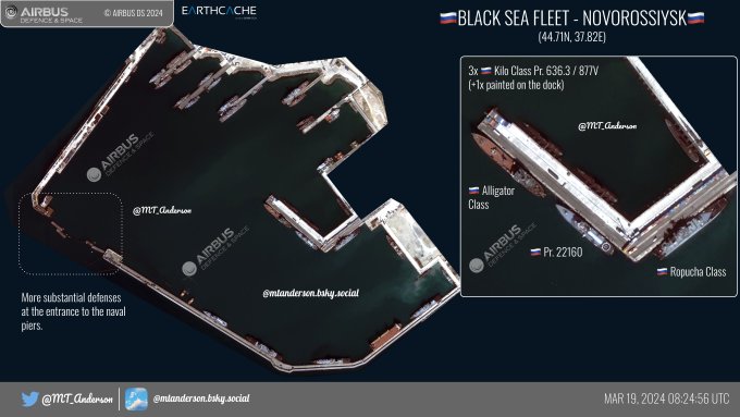
Clear evidence Russian Navy doesn´t feel safe from Ukraine´s Black Sea drones even inside Novorossiysk naval base. 👇 This is its entrance 5 days ago.

🇷🇺BSF-NOVOROSSIYSK🇷🇺
0.5M from 19 March 2024. Delayed order & delayed post. Packed house, the new normal, at the piers in Novo. 2nd time we've seen the painted KILO on the dock at the sub pen. Finally, increased protection at the entrance to the 🇷🇺naval piers?
9
79
461
3
10
57
Found pirate hijacked MV RUEN again TODAY.
She is at anchor 5.5 km from shore 60 km S of Eyl <yellow marker> and 160 km down Somalia coast from where I´ve found he before <blue dot>.
7.454, 49.737
#EUNAVFOR
#MaritimeSecurit
#shipping


Just noticed hijacked ship RUEN has moved from were she was in Somalia. Can be related to LILA NORFOLK incident just attended by India´s INS Chennai reposted by Sal 👇.
2
10
40
2
16
54
Vazante do Rio Negro ONTEM no começo do Arquipélago das Anavilhanas quase está juntando as primeiras duas ilhas na Baía do Buiuçú.
Área em cor bege são praias, em marrom está bem raso. Note como a água entre as ilhas está turva.

2
17
54
Bakhmut fires TODAY as seen by Sentinel 2 satellite SWIR. Very smoky in true color.
#UkraineRussiaWar
️


@davidhelms570
@NLwartracker
@bradyafr
@OAlexanderDK
@DefMon3
Sentinel 2A pass today and 2B pass tomorrow & Landsat 9 today, over Ukraine.
sources


0
0
3
2
12
53
France frigate Languedoc TODAY sailing Red Sea escorting MAERSK KINLOSS as part of Operation Prosperity Guardian 120 km W from Kamaran Island Yemen.
h/t
@mercoglianos
for comment on RT who enabled IDing
#IsraelHamasWar


Unidentified military vessels in TODAY´s Red Sea Landsat satellite image:
Images 1 and 2. 2 ships and 139 m escort 120 km from Kamaran Island at
15.37,41.41
3. 120 m at
13.72,42.43
4. 171 & 141 m at
13.60,42.52
#IsraelHamasWar


4
2
15
3
13
50

India Navy 🇮🇳 stealth destroyer and multi-role frigate spotted TODAY 4 km from each other sailing Gulf of Aden.
At right a Kolkata or Visakhapatnam-class destroyer <one of vessels listed on RT>, at left a Talwar-class frigate <same>. Blue line = ship route.
13.076, 47.570

09JAN2024 Updated map of warships operating in Red Sea, Gulf of Oman, Gulf of Aden, Persian Gulf, Arabian Sea.
Updates:
ENS Alexandria (F-911) spotted 140KM SW of 🇸🇦 Al Qunfudhah
India has announced more ships to be deployed as part of "Enhanced Maritime Security Operation"

12
85
237
4
9
48
Russia´s 🇷🇺 Black Sea Novorossiysk naval base entrance construction and defenses status annotated high resolution satellite image.
They sure scared.
Field truth pics from a couple months ago by ATESH via
@unian
.


🇷🇺BSF: NOVOROSSIYSK🇷🇺
0.5m📷 (10 June 2024, delay from the provider)
Some amphibious/warships have returned
3x Pr. 21631 Buyan-M still missing
Several Ropucha's still missing
1x KILO missing
1x Pr. 22160 (TOR Mounted) appears to be loading via the jetty, could be sailing soon


5
56
152
1
11
52

🚨 NEW 🚨Stricken Al Hudaydah Airport TODAY´s satellite images.
N apron target looks to be a 20´x 8´ x 8´ Containerized Command & Control Center< illustrative pic>.
S target looks to have had more bang in it for secondaries based on scorch marks.
#OperationProsperityGuardian


Al Hudaydah Airport TODAY´s satellite image.
Near Red Sea just S of town it was already beaten & looking abandoned. Most hangars still standing are now gone.
Two scorched spots are prob where drone launching vehicles were hit.
#operationprosperityguardian
#Houthis
#shipping
9
36
100
4
12
50
Kakhovka Reservoir water level drop at Zaporizhzhia Nuclear Power Planet TODAY.
#Zaporizhzhia
NPP
1
23
48
7 cargo ships and 1 military escort TODAY spotted by satellite sailing Black Sea humanitarian corridor; "an export lifeline for Ukraine".
Large one <300 m> is at a relativelly shallow route. Note how much sediment in suspension at her wake.
#Ukricor
#grain
#shipping


Today the 100th ship departed the Black Sea humanitarian corridor - an export lifeline for Ukraine that has delivered 3.7 million tons of food & goods to the world.

101
888
4K
5
6
48

Vuhledar TODAY´s satellite image shows Russians keep being hit at usual spots.
Note dark fire scars from previous days. Footnote, I did count 23 motorcycles abandoned there around hit vehicles. Way to go. Carry on Russia!
#Donetsk


The Russian Mad-Max tactics along the frontline using motorbikes are the latest form of suicide. They tried to break through Vuhledar, again, and it ended in a catastrophe for the Russian invasion forces, as the video and the pictures illustrate.
It is obvious that the
105
708
5K
2
10
48
Contrary to rumours Israel related highjacked ship GALAXY LEADER is NOT docked at Hudaydah Port TODAY.
Similar sized ship on Landsat satellite image below is CATALONIA, info confirmed by
@TankerTrackers
.
2
10
45
TODAY sailing 94 km S of Aden, Yemen, China´s PLAN Linyi 547🇨🇳.
Part of the country 45th Escort Task Force this Type 054A frigate is patrolling Gulf of Aden waters and thus indirectly helping maintain ship traffic going to and from Suez Canal.
#RedSea
#IsraelHamasWar
#Houthis

🇨🇳45th Escort Taskforce🇨🇳
Likely spot on Sentinel 2📸 from 8 Dec 2023 of the Frigate Linyi (547) in the Gulf of Aden. Based on the presser, you have to make a reservation for an escort. Maybe thats why the PLAN hasn't responded to other vessels, they weren't on the calendar🤷♂️

0
7
30
1
10
47


In addition to warehouse on fire TODAY 3 artillery ammo storage revetments were also hit at Olkhovatka, Voronezh, Russia🇷🇺 👇
50.292139, 39.259944 <northernmost one>
Proof on thread.


Fire and explosions at the Russian ammunition depot in Olkhovatka, Voronezh Oblast, were captured in a
@planet
satellite image taken today. At least two epicenters can be seen, which is consistent with reports about two drones. Location: 50.289960, 39.257510
@GeoConfirmed

5
137
719
5
10
45
Rafah TODAY & 5 DAYS AGO before Israel began a offensive there; part of Gaza Strip invasion.
Tank tracks clearly visible, white spots disappearing are destroyed buildings, dark areas on satellite image had been shelled and are covered by explosion dust/debris.
#IsraelHamasWar
2
13
43
TODAY´s Netzarim Corridor satellite image shows gravel road was tar sealed. Note black line.
Tarmac is a strong durable surface made when a layer of crushed stone is coated with tar.
Evidence Israel will be in Gaza for a good while.
RTed video via
@orfialkov
#IsraelHamasWar

4
15
44
TODAY on Gulf of Aden patrol India´s INS Mormugao D-67🇮🇳 Visakhapatnam-class stealth guided-missile destroyer.
13.122,49.456
250 km East along Maritime Security Transit Corridor MSTC cargo ship doing pedal to the metal sailing.
#Houthis
#Yemen
#IsraelHamasWar


Djibouti port TODAY 10 m/pix true and false color satellite image for future reference:
Korea🇰🇷 ROKS Yang Man-Chun DDH-973 136 m
India🇮🇳 INS Mormugao D-67 163 m
Spain🇪🇸 ESPS Victoria F-82 139 m
#IsraelHamasWar
#OperationProsperityGuardian
#Houthis
#Yemen
#Iran


2
6
20
2
5
44