

Matt
@Souza101Matt
Followers
736
Following
1,297
Media
1,277
Statuses
9,657
MMES @UVI . Global Change ecology. Seagrass/Corals/Inverts Restoration, Invasive species Coastal marine habitat, marine diseases. weather/climate.
St. Thomas US Virgin islands
Joined October 2017
Don't wanna be here?
Send us removal request.
Explore trending content on Musk Viewer
Hurricane Milton
• 720394 Tweets
60 Minutes
• 499245 Tweets
DeSantis
• 483543 Tweets
The View
• 225145 Tweets
Rigathi Gachagua
• 184922 Tweets
Iniesta
• 151831 Tweets
Jets
• 120122 Tweets
Saleh
• 101231 Tweets
Burna
• 78579 Tweets
Riggy G
• 73858 Tweets
Medicare
• 69543 Tweets
Bob Woodward
• 67600 Tweets
Rodgers
• 59356 Tweets
Nobel
• 57092 Tweets
Howard Stern
• 53136 Tweets
BBS RAIN
• 46841 Tweets
National Assembly
• 36891 Tweets
Calderón
• 29133 Tweets
Logan Act
• 27299 Tweets
Gustavo Macalpin
• 19588 Tweets
Junet
• 19295 Tweets
Rima Hassan
• 16604 Tweets
Bielsa
• 16266 Tweets
كمال عدوان
• 16064 Tweets
Hackett
• 15815 Tweets
Igor
• 12840 Tweets
NEW LOOK OUT NOW
• 12699 Tweets
Velma
• 12175 Tweets
Cameroon
• 10622 Tweets


Pinned Tweet

It was very cool working with a great group of scientists to better understand what was the cause of the mass mortality event in 2022.
#Diadema
#massmortality

5
4
22
@michelledlcueto
@natashaldaly
as a marine and environmental scientist zoos and aquariums are important so this narrative that zoos and aquariums are bad need to stop. What are being targeted are bad facilities like the ones seen in tiger king
13
33
1K
@JoshuaPotash
Of course republicans are now upset about climate activists going to the white house entrances. My response if you dont care about the January 6 situation, then you should have no problem with this.
3
44
817
@UkraineNews0
Why are families being split apart like this. Go with your families to the safe zones.
99
13
763
@JoshuaPotash
some of the comments on here are appalling, this is a kid that was shot by a police. this is police brutality we should be outrage what ever color or sex the person is. Just because he is a white male does not make this less important.
19
16
500
@WoodruffSidney
There are people out there that are looking for positive things to talk about because of the pandemic. Talking about new hobbies can be one of those things.
15
4
524
@CarolinaHuddle
Everyone saying how Jones is dirty in this play yet seem to not pay attention with how 53 pushed Jones down into the turf after the strip sack.
20
2
97
@EAGsquared
@WoodruffSidney
how is people having hobbies that helped them go through the pandemic toxic positivity? What was positive is that people who could, mental health was not completely fried. It is very unfortunate for those that couldnt do it & there should be more resources for those people.
3
2
97
@celestelabedz
Kody likes to make sure everyone knows he is there and If I don't let him come up on my lap, when he wants too, he will make having the meeting impossible.

1
1
79
@NFL_DovKleiman
@JFowlerESPN
1. He is asking for to much guaranteed money. GMS/Owners making a statement
2. He is a heavy run QB & risks injury. People like Mahomes/Allen rather pass than run
3. the entire offense would need to be changed for this guy.
4. Ravens will match any offer.
17
2
73


I see the EURO is day drinking **** not a forecast**** EURO would send a Cat 3 hurricane right into RI with the Cape and Islands absolutely battered. I believe there will be alot that prevents this type of storm track.

15
3
74
Two AEWs look to be needing to be watched. the ECMWF is more robust with it than the gfs. This is probably due to the fantasy CAG system the GFS has. Do I expect it to amount to much more than a AEW not at this time but its outside of 7 to 10 days . Light ensemble support.
0
14
68
@JustMaintain
@AOC
Mark, no one can just pay out of pocket for college these days. I went to community college then a 4 year college. Lived @ home with parents, worked 40-50 hour work weeks in the summer, worked nights/weekends during school year. Worked winter break & still had to take loans out.
14
0
60
@Jonah697182981
@UkraineNews0
proper men make sure they are there for their family. If they die they can not protect their family from war and post war situations. If he wants to fight so be it if not he should be able to go with his family
10
2
53
@TheOceanCleanup
how are you getting all that stuff so clean? Should be covered in fowling animals and algae. also no bycatch? Sorry but seems staged.
2
1
59
@tonyyoung1968
@UkraineNews0
real men would make sure they are with their families and are there physically to protect them.
11
0
49
@UkraineNews0
For those thinking I don't understand etc. My point was if the guy does not want to stay & fight he should not feel obligated too, I would go with my family to the place they are being evacuated & protect them from there. If the person passes away he no longer able to protect
39
1
45
EPS shows 3 clear AEWs, the EURO is picking up on 2 & 3, but not the first one. CMC picking up all 3. 2nd wave seems to have most support. GFS is kind of on its own. As UKMET/KOREA models have something developing as well. The AEWs are still over Africa, so much will change


4
9
50
0
0
44
signs of the MDR waking up, but still alot of discrepancies among models.

1
4
40
@miss_squiddy
@michelledlcueto
@natashaldaly
no we do not need to see cetaceans jumping through hoops or letting people smothered in sunscrean use them as skis in tiny show tanks. But there is animal enrichment activities that are used, especially for animals that can not be easily returned to the wild.
0
0
38
@bankerlahti
@kevpluck
@Harvard2H
that is a small piece of the big issue, thats the issue with anthropogenic climate change is that everyone wants to point to one thing when it isnt.
1
0
35
@samthielman
why the heck would you panic, once in a lifetime experience with nature. You wont get in trouble being so close to animals if they went to you. Just be respectful of them.
12
0
32
CANSIP continues its uptick in the PRECIP anomalies especially in the MDR/Eastern Caribbean & Bahamas. Wind shear is below avg over the MDR. this is only one model. The CFS is also some what inline with the CANSIPS, we will see how others show as we go through the next week or so
1
4
33
@starryflo
It drives me crazy sometimes with the # of typos I find in my papers after I have gone through it several times as well as finding them after I sent it in. It makes me feel stupid its why when a paper is not for a grade I tend to have someone else look @ the paper for typos.
2
0
29
@the_truth_1977
@UkraineNews0
drafts honestly shouldn't exist if a person wants to fight they can. If not they should be able to go with their family.
11
0
24
2 main camps for invest 94L. 1 stays weak and faster west until southern lesser Antilles, 2 develops faster and moves well Ne of the islands like the majority of the activity this season. Spaghetti models leaning this way as well. Watch for trends

4
3
32
ENSO goes from east based El-Nino to possibly a more Modoki look come the winter based on the current ECMWF seasonal. Good news for the eastern USA if u like snow. Lets see if it is still the case come October.


2
7
29
(thread comparing GEFS/EPS)
GEFS/GFS has an AFrican Monsoon/AEW interaction developing late this week, Moonsoon energy is slowed due to Steering pattern/strength due to STS Don to the north. AEW moves off AFrica Mid week, & interacts with monsoon energy Next weekend
1
5
29
@batviruses
@Salem8ball
@michelledlcueto
@natashaldaly
what organization do you work for? Are zoos and aquariums as good as animals being in the wild, no. BUT, Zoos and aquariums are very important in conservation on several fronts.
1
0
26
Past three runs of the NMME has increased precip anomaly over the Main Development region/Sub tropics and moved Below avg anomalies further west/south.
2
2
28
Both GFS & EURO show increasing trades over the 3.4 region of the tropical Pacific, possibly slowing the warming of this area at least temporarily. Unfortunately, no signs of any decent trades in the Caribbean/MDR to at least give some relief from the abnormal heat the ECAR has.


2
5
28
@Barca39738770
@WhiteHouse
and trumpicans said that trump was ours and if we didn't like it to leave. I say the same thing back at ya.
0
0
20
Been an increase in support for the AEW in the Central MDR. 18z EPS continues the trend which is also inline with the GEPS. Will see if this is just a hiccup or if this continues tomorrow. Would mainly just be a beneficial rain for NE Caribbean.
1
5
28

Starting to see some signs in the Cuba/Bahamas area in the 7 to 10 day period. Been seeing it for a couple days and its been getting closer in time which tells me that it might be something we need to pay attention to come the start of June.


2
2
26
Latest CANSIPS for AUG/SEPT/OCT. August has become drier across the GOM. Wind shear despite a moderate El-Nino....


5
8
27
If this set up occurs, we could see yet another heavy rainfall event in the Northeast Caribbean.

1
1
27
Taking a 👀 @ the ITCZ/African monsoon, you can see some areas of spin within the trough, take a particular look to the left side around 38W 10/11N That is the area to watch & the piece in which the ECMWF/EPS is spinning up.
3
2
24
the difference between between EURO/GFS with the AEW, EURO faster, GFS a bit slower. GFS different between 00z & 06z. The difference between runs is what piece of the elongated 850V becomes dominant & 06z is slower than 00z. GFS is likely over doing it, EURO probably under


1
4
25
@LosTalksPats
@ezlazar
@Patriots
@NFL
Douglas needs to be the slot, keep JUJU on the pine he is to slow especially for a slot. This offense clicked when it has a shifty slot that can find the holes. Have not had that since Julian.
0
0
27
The first two weeks of July look to be unfavorable for tropical development but by mid-late July it looks to become favorable again in the Atlantic but it looks like its CCKW dominated which can be hard to pin point and usually gives a week or two of favorable conditions.

2
2
25
I fact checked this, and have to say I am seeing nothing that says otherwise. This could actually be conservative.

Estimated half a billion wild animals have died in Australian bush fires. They pay the price for our ignorance greed & stupidity
#AustraliaBurns


90
1K
2K
2
11
21
My Mom has been battling cancer since June, she went through Kemo through the Summer into early September. Today she had her surgery... Just got the news she is now cancer free.
5
0
23
an average with all the ENSO events that occurred over the summer since 1990... Now compare it to what the models are showing . Clear differences the PDO and the Atlantic SST configuration, both reasons why I am not sold on an inactive Atlantic season.


3
4
21
+ENSO developing currently & is east based which tends to decrease Atlantic hurricanes, but the Atlantic might have other plans. The MDR is warming while the mid-Lats are decreasing. This ATL configuration tends to increase hurricanes in the tropics


1
4
21
After Lee and Margot An AEW starting to show some signs of support from ensembles. Will depend on the speed of which Lee moves north & Margot moves north. Ensembles all over the place for this AEW as the AEW has yet to get to splash down as well


2
0
23
Winter outlook 2023/2024.
1. Strong El-Nino based on SSTS
2. MEI metrics are more inline with a weak to moderate El-Nino
3. Atmosphere not acting as strong/Super El-Nino
4. This is going to be a ENSO wide El-Nino, not east based.
4
3
20
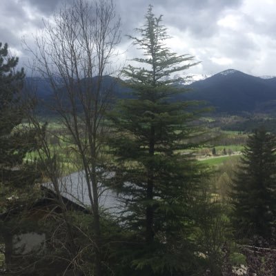
@ericfisher
I am down on St. Thomas USVI, I moved down hear from Massachusetts for Graduate School. Here is one of the pictures I took. I just missed the lightning shot which would of been cool.

0
4
18
The gfs & GEFS have gotten faster and has started to go to the ECMWF/EPS. Much weaker signal. Due to dry air, movement & the lack of ITCZ/African monsoonal interaction. Very typical for models to not have a good handle on a AEW until its over water.


1
5
20
May's ECMWF. This is alot of activity for an El-Nino. This is painting a picture of long tracked systems out of the MDR/Sub-tropical Atlantic Greatest risk Bahamas, East Coast & NE Caribbean. Wide range for Ace
#Hurricaneseason
#hurricanepreparednessweek
#hurricanetrack


1
2
19
ECMWF is showing I95L having a 40-50% chance of TD over the southern Lesser Antilles. The signal to the east, is the next AEW with part of it off the coast now but the other piece will not be off the coast of Africa until tomorrow afternoon.


1
2
20
*not a forecast**, expecting that this wave will not amount to much but the GFS currently shows the tropical wave developing east of 55W but then breaking down to the west of this line. Many waves will form to the east of this line this year I expect, but how many make it passed?
1
5
18
@InteriorPlaceX
@bhadrauli
and Arabs did the same thing to the Jewish people who were also killed just being there, need to see the entire history of the area before you post things. All sides have done atrocities when they were in power and when they aren't
1
1
19
ASCAT hit I95L this morning, You also can see how strong easterlies are shoving the mid-levels westward likely limiting its ability to organize for now. Despite that, latest hurricane guidance shows development over the next 72 hours. Currently looks to avoid Islands


4
5
20
AEW embedded in the African monsoon/ITCZ needs to be watched. These set ups are difficult for models to depict hence why models & Ensembles have & continue to be all over place with it. Where it consolidates determines overall survival of the feature & threat to ECAR 6 to 9 days

1
3
19
@ArtPetio
@patrickmustain
If its been out in the ocean even for a couple of weeks things will start growing on it. the "Pacific Ocean Patch" has been observed to have shallow water fowling species from Australia, Japan, USA, South America forming on it. It took 3 days for algae to start growing on traps
0
1
15
EURO/CMC good agreement that I94L needs to be monitored by those in the Lesser Antilles next week. Seems that High pressure placement, speed of east coast storm movement &, trough placement/time & forward speed to a point will determine threat level to the Lesser Antilles


3
5
19
@FishGuyKai
@kntsrgn
Its not pro-rock vs anti-rock stacking. Its an anti-rock stacking for the heck of it for social media. If its for a survival situation, its better than many other trail marking techniques several of which involves more invasive techniques or leaving non-natural materials
1
0
17
Timing of development of the EAW, trough placement, ridge placement, their strengths Lots of variables & that can be 👀 in the ensembles. Operational GFS is inline with the stronger faster developing storm, while Operational EURO is further SW closer to the ECAR


1
1
19
tropical storm Franklin forms in the eastern Caribbean. Continued strengthening is likely as it moves west/northwest tonight and will eventually make a hard north turn into Hispaniola. Flooding is the main concern. With the worst of it expected over Hispaniola.
1
1
19
@warmh20penguin
@JoshuaPotash
I have done things with my friends that are POC (Boston common). I have actually talked about many issues including police issues on facebook and twitter. This post was more towards the people literally saying good its a white kid that was shot maybe something will be done.
0
0
14
Some models are starting to catch on to a tropical wave that moves off of AFrica around the 18th. Which means 7 days until all the pieces are over the Atlantic which = high variability expected between now and then. Expect models to grab it and loose it
1
1
18
Models are still having a hard time with the monsoon trough & AEWs. through Tuesday. Below is the EPS and the EURO showing possible break down. I have a hard time trusting the EPS with its leading piece developing a system by the islands.


1
4
17
Atlantic hurricane season forecasts from agencies
NOAA 12-17 TS , 5-9H , 1-4 MH
UKMET: 14-20 TS , 8-14H, 3-7 MH
Accuweather 11-15TS 4-8H 1-3MH
CSU: 13TS 6H, 2 MH
IBM: 15TS , 7H 3MH
AS 19TS, 9H, 5MH,
avg of all 6
15 TS, 8H, 3MH
1
1
17
We are @ the point in which if we can not get anything really going despite the favorable 200V over AFrica, through the beginning and middle part of August, the season will likely be below avg in terms of tropical activity.

4
3
16
I95L @ around 25KTs this morning & has convective bursts occurring, the LLC is there but elongated from SW-NE, will see if it can get more circular & if so, can it survive with dry air to the North.
2
0
17
1
0
15
@sarahlsheffield
I said to professors and others with PhDs Dr. & usually get the response call me by my first name after the first couple of minutes.
1
0
14

GEFS ensembles shows uncertainty
Two camps. Faster moving wave threatening to the Islands. develops closer to the islands as well. (GFS) Camp two Slower moving wave curves prior to the islands . Inline with EURO.EPS.CMC, ICON, UKMET & KOR. Guess which I am going with right now

1
2
17
@bevtgooden
My dad worked during the summer & paid for all the school for that year!. I worked full time summer/part time school year. Still got 54000 in loans & that was going to community college 2 years before going to 4 year University. We went to the same University 30 year difference
1
0
15
ICON/CMC & EPS = 3/4 weak system for the 🐠⛵️
1. increase in showers, thunderstorms and increased seas for the Lesser Antilles
2. GFS/GEFS need to show us we can trust it before I give it much weight in predictions.
3. An area of low pressure will need to be watched off SE

2
4
14
@opendna
@HannahntheWolf
@wiredferret
I would go the route of if they require the students who are paying their salary needs to show a Dr's note, the professor needs to as well when he is out sick. We are paying her or him to be there, they are not paying us to be there.
1
0
15
@michelledlcueto
@natashaldaly
scientific papers showing the importance of aquariums and zoos. There are also those that show the other view of the negatives as well which there are but like anything in the sciences, It is very rare to be black or white. It is usually a shade of grey
0
1
15
Guidance has gotten weaker and has continued to the path to the east and north of the Caribbean Islands. It also looks like until its north of the Caribbean Shear/Dry air will keep it @ bay with nothing stronger than a TD/ Low end TS over the next 5 days.


4
3
12
Global models all in good agreement with the future of I95L through 5 days. After that, not so much.


1
2
14
An AEW currently moving off of Afrika today, has been having increasing support for possible development early to mid next week over the central MDR. Probably some of the best of conditions for June MDR development, so not really surprised.


1
1
14
I90L will struggle and likely not form until its in the SW Atlantic if at all. Energy off of south America along with a cold surge from SA could try and develop something late this week/weekend.

1
1
13
TS Philippe is moving W/NW at a rather slow pace. The eastern islands of the NE Caribbean from Antigua & Barbuda to Anguilla could see near tropical storm conditions. Else where rough seas are expected with enhanced shower and thunderstorm activity.

2
0
15
GFS/CMC starting to pick up on the AEW that is going to move off of Africa Wednesday. Looks to be the southern piece the GFS is gripping onto. would be more of a threat to SA and southern Windward/Leewards based on what the models are showing & climo
0
0
14
92L is organizing SW of the Cabo Verde Islands this evening. There is still a large variety of possibilities. High level of uncertainty will remain until a system develops. Another aspect of this is that the AEW is thats moving off of Africa now being picked up by models


2
2
14
@ChicagoMWeather
@NWSNewOrleans
@ReedTimmerAccu
@WXgage
@ryanhallyall
@Tornado_Steejo
u should be ashamed of yourself. Lying about needing help. You sir give the other storm chasers a bad name. Stick with tornado's
0
0
14
Looking at GEFS and EPS, you can see a slower developing system and faster moving system west threatens the islands while a slower faster developing system curves before the islands. We shall see. GFS is trending westward the passed 3 runs.


2
5
13
Both EURO?GFS has the wave that moves off the African coast developing. GFS higher and closer to dry air/shear is weaker through MDR but threatens land, EURO is lower, strengthens quicker and curves OTS.


2
0
11
Interesting convection orientation with the northern one being where the current LLC, both are strengthening. It be interesting if the northern piece remains dominant or the lower one becomes dominant or something in the middle. The mid level one is where the 850Vort max is.
1
1
14
GEFS ensembles are moving closer to the islands today. GEPS (CMC ensembles) have been moving over the NE Caribbean but less members and weaker. We will see what happens but I think the cap for this is a TS, with the low end being an open wave.
1
1
14
@JessicaKTx
Mac was throwing to open receivers and the receivers dropped the ball when the ball hit them right in the hands or chest. Plus the Defense didn't stop the Bills Offense the entire game.
1
0
11
TS Franklin doesn't seem to have a LLC anymore, several models showed this was possible but I am hesitant to believe the bullish strengthening of Franklin once above the islands due to unfavorable shear that continues to its north due to an ULL going through the Florida Straights
5
1
14
I am interested in how anthropological activity and invasive species impact predator-Prey relationships. Currently working with H. stipulacea affects on queen conch susceptibility to predation.
#TeamFish
#Inverts
.... Hybrid ;)


Help us share the diversity of people working with fishes! Quote tweet this (or each other) with a pic/what you do!
I study the ecology and conservation of gars and other “ancient” fishes!
46
250
2K
0
1
14
@allnbowtane
@nowthisnews
@Elasmo_Gal
@MISS_Elasmo
as a white straight man in the sciences to you. STHU. Your not a scientist first off. Two diversity does not degrade the quality, it improves it. I work with alot of woman and POC and they are just as smart as me.
2
0
11
@lolonurse1
@ChrisDJackson
@joncoopertweets
@JoeBiden
he lost that when he made fun of the reporter with the disability & said things about Biden's stutter. As someone with a speech disability kindly STHU
0
0
7
GEFS VS EPS Operational VS EPS PAR. 12z PAR & GEFS 18z rather similar with a TD/TS developing and then moving northeast of the Island. Very typical pathway for EL-Nino/-NAO dominant seasons.


1
1
13