

Eastern Scotland Wx
@EastScotland_Wx
Followers
2,979
Following
420
Media
6,452
Statuses
37,842
Based in E Scotland and will provide frequent weather updates for Scotland . I will also occasionally cover severe weather across the Globe and the UK
Perth, Scotland
Joined June 2017
Don't wanna be here?
Send us removal request.
Explore trending content on Musk Viewer
McDonald
• 996751 Tweets
Dodgers
• 268505 Tweets
Yankees
• 190070 Tweets
World Series
• 146303 Tweets
Jets
• 136376 Tweets
Mets
• 108569 Tweets
#SB19forMagpasikat2024
• 103495 Tweets
SB19 MAGPASIKAT SA SHOWTIME
• 100715 Tweets
ドジャース
• 72488 Tweets
Fethullah Gülen
• 69001 Tweets
#Magpasikat2024ViceKarylleRyan
• 68865 Tweets
Moldova
• 48895 Tweets
ワールドシリーズ
• 36136 Tweets
I LOVE NEX BUS
• 33187 Tweets
King Charles
• 26933 Tweets
Ateşi
• 25574 Tweets
I LOVE THAI BUS
• 22996 Tweets
Başın
• 19746 Tweets
Happy New Week
• 19551 Tweets
पुलिस स्मृति
• 16419 Tweets
レイエス
• 15718 Tweets
Lidia Thorpe
• 13748 Tweets
Darısı
• 13474 Tweets
DwiTUNGGAL PRABOWO GIBRAN
• 13124 Tweets
Geberdi
• 13109 Tweets
SelamatBEKERJA UntukBANGSA
• 12561 Tweets
Ergenekon
• 10031 Tweets


Pinned Tweet

ECM begins at 6pm
ICON begins at 1440
GFS begins at 1540
GEM begins at around 1640 ish
ICON 12z begins in 1hr 30 minutes
GFS 12z begins in 2hr 30 minutes
2
1
6
1
2
7

The final wind watch has been issued for
#StormCiara
which will hit the UK Saturday night and Sunday.
> many places having gusts of 60mph+ with a few inland places possibly hitting 70mph and coastal areas will likely see 70-80mph ( locally 85-90mph for NW Wales).

17
198
259
@VijayJayaraj_CC
@UNFCCC
yes July contains showers and thunderstorms regularly there, but what you showed is rain days not rainfall amounts, 8 months of the average rainfall amount fell in 1 day.
1
1
167
@piersmorgan
This is Piers trying to go an hour without tweeting the words Harry and Meghan.

2
7
152
Aberdeen AB25
#uksnow
9/10.
Very intense snow showers and winds really whip up within them.
3
26
145
@TamdhuL
@NicolaSturgeon
@UKSupremeCourt
Population per MP:
England: 105k
Scotland: 92.4k
Northern Ireland: 104k
Wales: 78.5k.
Pretty equal to me. In fact Scotland gets more MP’s for its population over England.
10
4
105


Had some pretty tasty snowfall last night up in Perth. Measured around 25cm or so at this point. Might get another 5cm on top of that!
#uksnow
PH2

9
10
103
A solid foot of snow here.
@highlandweather
@SeanBattyTV
@metoffice
@gregporter_wx
@Petagna
@peikko763
@UKWX_
@Anthonygrist22
@alex_wxuk

10
15
105
@NoContextBrits
Jesus Christ I thought this was genuine for a good few seconds. My heart skipped a beat there.
0
2
98
Photos and videos of the snow earlier this morning.
7
12
84
Big increase in wind gust forecast for 11pm to the west of Scotland on 18z Arpege vs 12z . Very bad news for the central belt.


4
25
80
Very heavy intensity snow in PH2 ( Perth ) 40m 10/10
2
7
73
Some in the community this week:
Expectation. Reality.


4
8
77
While I was middle watching a film, I missed out on seeing this very nice double funnel cloud visible from my village which was filmed from the Abernethy Facebook group.
I haven’t given account name but this further credit will be given if requested.
7
15
71
Some spectacular lightning near Perth Scotland.


5
12
67
Here are all the rain gauges which have recorded 50mm or more since Friday evening. A large swathe of 80mm+ from west to east coast and 1000s of square kilometres have seen well over 100mm. I suspect this is at least a 1 in 10-20 year event.

2
28
68
At around 10cm now and still moderate to heavy snow. This is amazing!

5
5
67
Since there is lots of exactment about snow prospects at the moment, I've decided to create 4 graphics which each show where the precipitation coverage is the greatest depending on the wind direction (assuming conducive profiles for convection).


9
18
62
@NoContextBrits
I had fun in Blackpool… but it’s an absolute shithole the moment you leave the street behind the promenade.
4
0
58
OTD 12 years ago was the beginning of the almighty December to remember.

2
9
56


3
9
49

Just had my first proper falling snow since late November!

3
4
51
Here are some of the lightning shots I captured on video last night!


4
10
50


Very very very snowy morning here in Aberdeen. Currently snowing and more on the way. Not measured it but an absolute minimum of 4-5cm with may as much as 8-10cm


2
5
48
Thought I would do a very lazy graphic highlighting where the low pressure centre from the developing sub tropical tropical storm could be at day 10 and it may affect the UK.

7
5
45


SNOW WATCH ISSUED for Feb 8th 2021:
HIGH AREAS: typically around 5cm quite widely ( less or more depends where you area) , locally 15cm+ in these areas.
MOD: typically 1-4cm widely here. Few places seeing 5-10cm!
MIN: A covering in several locations, 3-8cm possible locally.

4
9
43


The eastern Atlantic Ocean is looking toasty right now. Wonder how this will influence summer for W Europe?

10
2
42


👀👀 well this has caught my attention! Spine of the UK could see a covering ( or in some spots an additional 1-3cm ) of snowfall from this little feature moving through the UK tomorrow. Uncertainty on the intensity and snowfall coverage on this feature though.
1
6
40
Illegal


Who wants to see an illegal ECM ensemble member? Something which is insane!
1
0
13
4
2
40


5
8
38


Here I introduce you to my new weather station. It’s a Davis vp2 wireless. Didn’t have much luck from delivery to setting it up, but we got there in the end!


6
2
40
Damn. Some very extreme conditions likely across northern Britain next week with the risk of severe blizzards over the hills of Scotland and on top of that, bitterly cold wind chills.


3
8
41
6
6
38
A historical past 4 days in terms of UK rainfall. All rain gauges are ones which have recorded 50mm or more with some areas such as E Scotland and parts of yorkshire seeing over 100mm widely which resulted in severe flooding in these places.


3
10
39
ECM model brings EX Lorenzo into the west coast Ireland with gusts in excess of 170kph ( 105 mph ). this needs watching.
@hurricanetrack

2
17
37

RIP Southern England: ECM operational run was not an outlier. Ensembles show it just keeps getting hotter and hotter and hotter there over the next 10 days. Quite a significant heatwave possible.

11
7
38

Watch the cold air spill into our North During the next 4 or 5 days. There will be plenty of frosty nights and cold, crisp Days.
1
7
32


Went for a Hill walk earlier today. The hill top was just peaking out the fog and i managed to capture a “Fog Bow”? . I also managed to captured the distant hills peaking out the fog with the fog sitting in the valley as well as some forest pictures in the half burnt fog.


8
9
35
Only if I was back home in Perth right now I would be able to see the Aurora 😂. Photos taken by my parents, first 2 photos are night mode and last photo is what is seen with naked eye. Fkn jealous 🙃


3
4
37
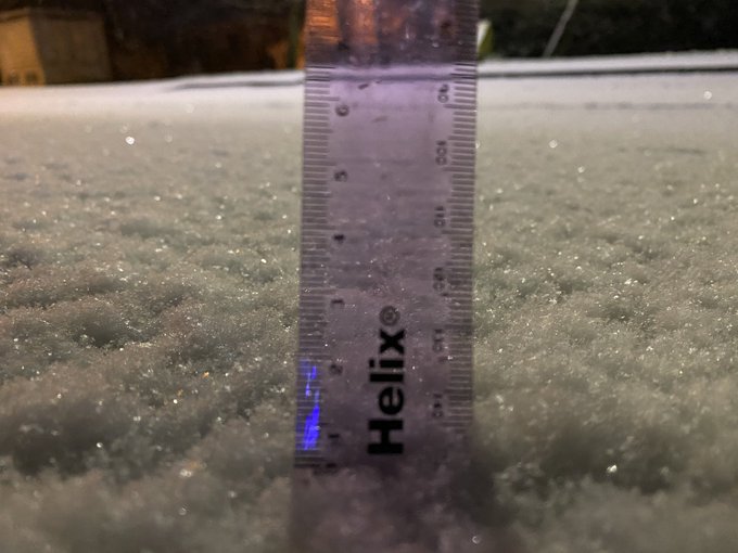
Done 4 measurements, couple on a path, one on bench and one on bin. General consensus is 12cm


3
7
37
CONVECTIVE OUTLOOK issued for 03/07/21:
> Showers and Thunderstorms will develop widely and along convergence lines these showers and storms will be enhanced due to the extra upwards forcing meaning some places could see several rounds of T-Storms allowing severe flooding.

6
8
37
This snow shower 2 years ago today marked the beginning of 36 hours of heavy and frequent snow showers pilling in from the east in Perth. This shower alone dumped around an inch of snow in 20-25 minutes.
4
4
35

Round 2
6
3
34
I know the Tornado report is to the west of where this cell is, but wasn't really enough to show as we don't have access to doppler, but these composite radar images do show a general hook feature on the southern flank of this storm, looks like we had a tornadic supercell!


2
7
34
4cm or so consistently measured around my back garden!


0
5
36
SNOW WATCH ISSUED for Tomorrow:
> A SIG has been put in places for parts of central Scotland, here there could be 10-20cm overnight and tomorrow, though 30cm+ can't be ruled out. The HIGH area will allow many locations to an a additional 5-10cm widely....

4
8
34
ECM day 10 is boiling hot. Good chance this may not happen to this extent but never or less its an exciting chart to see, Surface temperatures across the Uk ( Including Scotland) will see mid to high 20s widely if this comes off, possibly 30 or 31C.


7
3
32
So I'm going to be leaving the UK Wx community which I'm going to miss but I'm still going to be around on Twitter. I'm now going to be more focusing on USA weather since I'm moving to Buffalo in New York tomorrow. Didn't want to say until things were finalised for the move.
16
1
33

An updated wind watch has been issued for
#StormCiara
which will hit during sunday. The Following wind gusts is most likely at this stage:
> Midlands= 60-70mph.
> South east England= 65-75mph.
>western coasts = 70-80mph.
>Eastern England / East Scotland= 55-65mph.

5
13
30

Time to measure. Gonna do probably 10 readings on several different surfaces and come to an average. Measurements will be representative of Aberdeen city.
@metoffice
@Silkstiniho
@Petagna

2
1
31
Left pic shows what ECM showed for 8th Feb this year , Right picture is what actually happened… can’t find what GFS showed though.


5
0
31
Strong line of storms have developed over Cornwall and Devon bringing copious amounts of rain and frequent lightning!

2
5
33
A few of my measurements. In most open areas I’m finding about 5-6cm.


1
1
32
SNOW WATCH ISSUED for Sunday and Sunday night where some snowfall is likely across Southern Ireland and southern England/Wales. 1-3cm widely in most spots, locally as much as 5-10cm across southern England. Further details can be read on the graphic itself.

3
4
29
So I decided not to issue a snow graphic for tomorrow. However I have outlined on what areas will see what types of precipitation tomorrow.
>Snow will fall generally Inland above 200m or so.
> Wintry mix will fall Inland generally.
> Rain/sleet will fall right more...

5
2
30
(From netweather)
Severe flooding in a neighbourhood just north of Dundee.

(Stole From Netweather forum)
Looks like several homes just to west of Dundee have been flooded from the invergowrie burn which has burst its banks completely from yesterdays and last nights heavy rain.


2
9
20
2
10
31
This day 4 years ago brought a significant snowfall event across the Midlands where 5-10cm fell widely , with some spots seeing upwards of 20cm!

We've seen 28cm of snow across the high ground of Wales now, and snow continues to fall elsewhere. Thanks to
@LukeMiall
and
@GreavesToni
for the following pictures. If you have any nice shots of today's weather send them to
#loveukweather
-We'll show more of our favourites later


41
108
149
3
2
28