
Ben
@zeb199818
Followers
1,108
Following
144
Media
1,547
Statuses
1,985
Satellite Images (Himawari/GOES/Meteosat ....) Model Figures (GFS/ECMWF/ICON/CMC) Tropical Storms/Typhoons/Hurricanes/Cyclones
Taiwan
Joined March 2012
Don't wanna be here?
Send us removal request.
Explore trending content on Musk Viewer
İran
• 516637 Tweets
Argentina
• 404124 Tweets
Kyle
• 266250 Tweets
Shapiro
• 220459 Tweets
Sunderland
• 141482 Tweets
Enrique Márquez
• 114558 Tweets
オフサイド
• 104474 Tweets
Francia
• 95175 Tweets
スペイン
• 94450 Tweets
#ErdoğanınYanındayız
• 80012 Tweets
Emily
• 68747 Tweets
Mascherano
• 65103 Tweets
İmamoğlu
• 60623 Tweets
Julian
• 60027 Tweets
Ron Paul
• 47334 Tweets
Arabia
• 43503 Tweets
#FRAARG
• 38019 Tweets
Angola
• 29999 Tweets
Game Informer
• 29115 Tweets
Fresh News for $XRP Holders
• 27137 Tweets
Hepimiz Erdoğan'ız
• 25090 Tweets
Joshua Cheptegei
• 20043 Tweets
BAUTISTA EN EL GRAN REX
• 19375 Tweets
準々決勝進出
• 18919 Tweets
Equi
• 16549 Tweets
Zenón
• 16470 Tweets
Mateta
• 16351 Tweets
Simeone
• 16263 Tweets
#バレーボール男子
• 15682 Tweets
Gabriel Sara
• 14118 Tweets
Almada
• 13455 Tweets
Otamendi
• 13056 Tweets
FGOフェス
• 12480 Tweets
Grant Fisher
• 10862 Tweets
Echeverri
• 10664 Tweets
Harmeet
• 10377 Tweets
منتخب مصر
• 10147 Tweets


#Colin
never entered to ocean when it was a tropical storm.
Textbook needs to be re-written. TC can born in land.

7
6
64


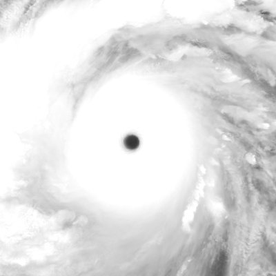
NOAA Sentinel-1 SAR latest 300-m resolution level-2 data still shows 155kt (reach upper limit 155kt) wind of Super Typhoon
#BOLAVEN
.

1
10
56


1
10
51
#Hurricane
#Felicia
Satellite :
#SNPP
#VIIRS
Time : 2021/07/17 1002Z
@UWCIMSS
@NHC_Pacific
@NHC_TAFB
@NOAASatellites


3
14
52


The vertical wind shear is dramatically decreasing now.
With very favorable condition,
#Rai
is undergoing rapdi intensification now.
High end CAT-4 or even CAT-5 is expected.


3
7
46


3
6
47


GFS 2023/05/26 06Z Typhoon
#Mawar
Lowest central pressure : 863.8 hPa
Highest 10-m height wind : 165.4 kts


4
7
45


2
2
44


3
10
42


#HINNAMNOR
is undergoing eyewall replacement cycle again. Typical concentric eyewall structure.

2
3
39


#ECMWF
new version 48r1 has released for than 2 months. The resolution of ensemble improves from 18km to 9km, which will lead more stronger TC intensity.
However, the forecast for future cyclones in Bay of Bengal is extremely different.


1
6
40


1
6
40


Indonesia
#Ruang
#Volcano
Eruption
Satellite:
#Sentinel3A
#SLSTR
Time : 2024/04/17 1344Z
#ruangvolcano


0
8
38


Hurricane
#Dora
is entering into higher SST region, low vertical wind shear environment will last for 2-3 days. Further intensification is still possible.


3
4
36


#MOCHA
is undergoing rapid intensification under relatively low vertical wind shear environment today.


0
5
36


#GFS
forecasts extremely strong extratropical cyclone in 357h. The central pressure is 915.5mb. Strongest cyclone in North Atlantic?😏

9
4
37


1
5
35
The strong vertical wind shear limits the speed of cleaning eye of
#MOCHA
. However, it is still a catastrophic cyclones for Myanmar.


0
6
34


1
7
35


Incredible. Hurricane
#Dora
is recovering from strong vertical wind shear and re-intensifying again. However, another extremely violent vertical wind shear is coming very soon.


0
4
33


Favorable outflow triggers the development of the outer rainband of
#Mocha
, which accelerates the secondary eyewall formation. Unfortunately, eyewall replacement cycle may generate large wind filed and tend to cause more damages.


1
4
33
ECMWF forecasts
#Fiona
will become a 925 mb incredible extratropical cyclone and land with 932 mb pressure.


2
5
32


#Mediterranean
tropical-like cyclone
#Medicanes
Cyclone
#Daniel
Satellite:
#JPSS1
#NOAA20
#VIIRS
Time : 2023/09/08 1158Z


2
7
31

#ECMWF
forecasts the tropical cyclone activity will be very active in Western Pacific Ocean in middle of August.

2
3
31


#15W
Super Typhoon
#BOLAVEN
Satellite:
#Sentinel3B
#SLSTR
Time : 2023/10/11 0022Z
Eye Temp : 24.58 °C


0
7
31


Don't be cheated by IR pattern (DT7.0) of Tropical Cyclone
#DARIAN
, in fact, it is undergoing eyewall replacement cycle.


1
6
29
Latest news!
2020
#JTWC
Annual Tropical Cyclone Reports has published.
The reference of cover image should be revised.
It's from easterlywave () not NRL.

2
7
30


1
2
28