

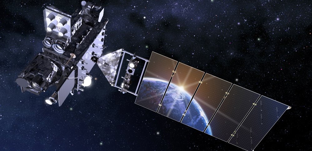
NOAA Satellites
@NOAASatellites
Followers
2M
Following
37K
Media
9K
Statuses
25K
The NOAA Satellite & Information Service (referred to as NESDIS) is a line office of @NOAA.
Silver Spring, MD
Joined April 2009
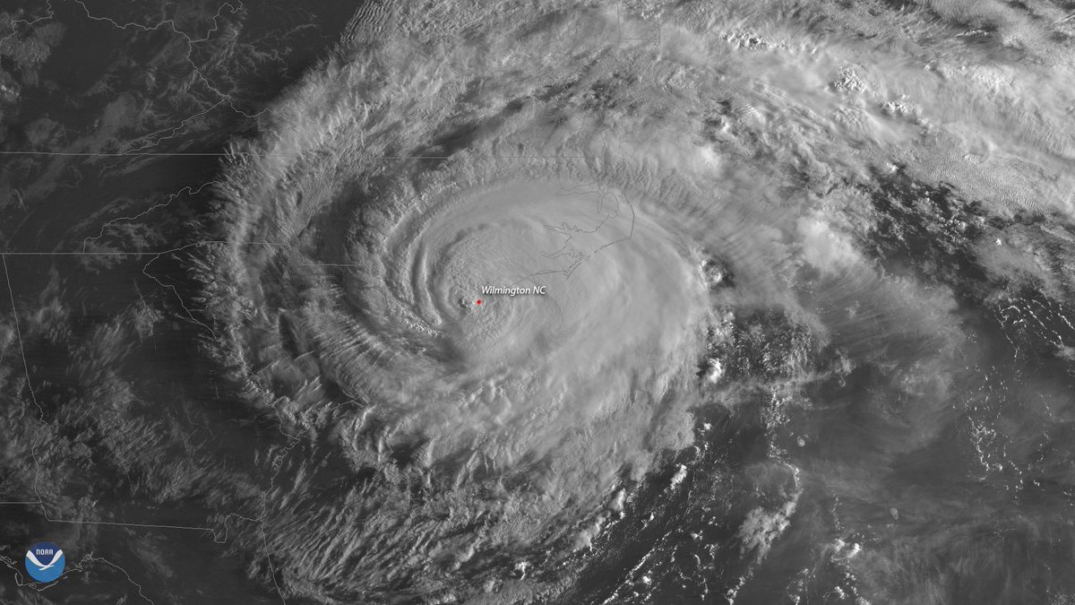
#GOESEast captured these two dramatic views of #HurricaneFlorence shortly after the storm made landfall near Wrightsville Beach, NC this morning. Latest updates:

427
2K
11K
Watch as the eye of #HurricaneDorian2019 begins to form in this 1-minute visible loop from NOAA's #GOESEast. "Dangerous Hurricane #Dorian poses a significant threat to #Florida and the northwestern #Bahamas," according to the @NHC_Atlantic. Latest:
643
4K
10K
Happy #WinterSolstice!.To celebrate, we collected an image per day over the last year from #GOESEast, taken at 1200 UTC, and looped them together. You can really see how the seasons change from #equinox to #solstice due to the #Earth's 23.5° tilt.
174
5K
9K
Watch the moon's shadow move across the US in this geocolor loop from #GOES16! See more #SolarEclipse imagery @
86
5K
8K
This imagery from @NOAA's #GOESEast 🛰️ is providing visible cloud imagery every 30 seconds of #HurricaneMilton as it pushes closer to Florida. Notice the frequent #lightning being picked up by the satellite's #GLM instrument as well. Get the latest on #Milton:

Hurricane #Milton Advisory 19: Milton Approaching the Coast of West-Central Florida. Life-Threatening Storm Surge, Damaging Winds, and Flooding Rains Expected Across Portions of Central and Southwestern Florida.
119
2K
7K
Today's total #SolarEclipse was the only total solar #eclipse of the year. Although it was mainly visible from Earth in parts of South America, #GOESEast had a perfect view of the moon's shadow moving across the Earth.
58
1K
6K
EYE OF A MONSTER: @NOAA's #GOESEast 🛰️ gives an up-close look at the lightning swirling around the eye of #HurricaneIda, a dangerous Cat. 4 #hurricane, nearing the coast of southeastern #Louisiana. Please stay safe! . More: #LAwx #MSwx #idahurricane #ida
110
2K
5K
For this #WednesdayMorning, take a look at #HurricaneLaura with @NOAA's #GOESEast satellite as the hurricane's convection bursts with lightning. As of 8 a.m. EDT, #Laura had winds of 115 mph and was rapidly intensifying in the Gulf of Mexico. Latest:
93
2K
4K
The #GOESEast satellite captured this close-up of the menacing eye of Category 4 #HurricaneFlorence this afternoon as the storm continues its trek toward the East Coast. Latest:
125
2K
3K
This #FullDiskFriday, the #GOESWest satellite is continuing to watch the sobering amount of smoke from wildfires spreading across the #WestCoast of the U.S. @NIFC_Fire says there are 102 large wildfires and so far, more than 4 million acres have burned.
171
2K
3K
#GOESEast captured this incredible view of the inside of #Hurricane #Ian's eye as the storm approached Florida. Latest: #FLwx
39
1K
3K
Watch a replay of the moon's shadow traveling across the path of totality, seen from @NOAA’s #GOESEast satellite. #TotalEclipse #Eclipse #Eclipse2024, #TotalEclipse2024 #NOAATotalEclipse2024, #2024Eclipse
34
1K
3K
Like the famous "Earthrise" photo taken from the #moon, this image, captured by @NOAA's #GOESWest 🛰️on March 6, 2020, shows the moon rising over the Earth. Can you see it?. We hope you feel as lucky as we do to see this beautiful image on #FullDiskFriday and #FlashbackFriday!

37
730
3K
As #HurricaneDorian approached the #AbacoIslands, NOAA's #GOESEast zoomed in on the powerful storm's eye. The Cat. 5 storm's "maximum winds have increased to near 175 mph with gusts over 200 mph," according to @NHC_Atlantic. Follow the storm:
80
2K
2K
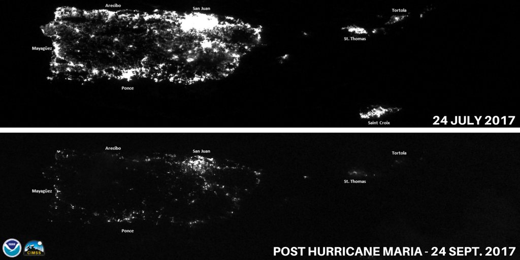
Satellite night images of #PuertoRico. #HurricaneMaria knocked out power grid, millions without electricity. More @
85
3K
2K
Happy #FirstDayofFall! The autumnal #equinox is at 9:54 pm EDT today. Day and night are nearly equal everywhere on Earth, as seen from @NOAA's #GOESEast satellite.
39
1K
2K

These side-by-side infrared images from @NOAA satellites show the two devastating landfalls of Hurricanes #Katrina and #Ida, which occurred #OnThisDay, exactly 16 years apart. *Note: Images are not on the same spatial scale.

54
813
2K
And with that, #SolarEclipse2023 has traveled from Oregon to Texas. Watch the view of the shadow from @NOAA’s #GOESEast as it moves across the Pacific Northwest to the Gulf of Mexico.
19
616
2K
Happy #WinterSolstice! 🌎🌄❄️. Astronomical winter officially starts at 10:27 pm EST, marking the longest night in the Northern Hemisphere. Enjoy a year-long visual journey with daily images from @NOAA's #GOESEast 🛰️, showing the changing seasons due to Earth's 23.5° tilt.
26
773
2K
HAPPY LAUNCH DAY!!! NOAA #GOESS (#GOES17) is a GO for launch, the countdown begins in just a few hours! The Atlas V rocket carrying the mission was rolled to the launch pad at Cape Canaveral's Space Launch Complex-41. Photo @ULALaunch Learn more:

28
627
2K
After conducting a post-storm analysis, @NHC_Atlantic determined that Hurricane #Michael's estimated intensity at landfall was 160 mph, making it only the fourth Cat. 5 hurricane on record to make landfall in the U.S. More:
48
1K
2K
This morning's #GOESEast view of the powerful #BombCyclone as it batters the East Coast with heavy snow and strong winds. #noreaster #blizzard2018. More satellite imagery:
60
1K
2K
Today the #VernalEquinox will occur at 5:24 p.m. EDT in the Northern Hemisphere, marking the start of #AstronomicalSpring!. This animation shows the angle of the sun changing from last year's vernal equinox through today due to the Earth's tilt.
30
614
2K
Here is the current view of #HurricaneIda churning over the Gulf of Mexico, courtesy of the #GOESEast 🛰️. Get the latest on #Ida: .
51
785
2K
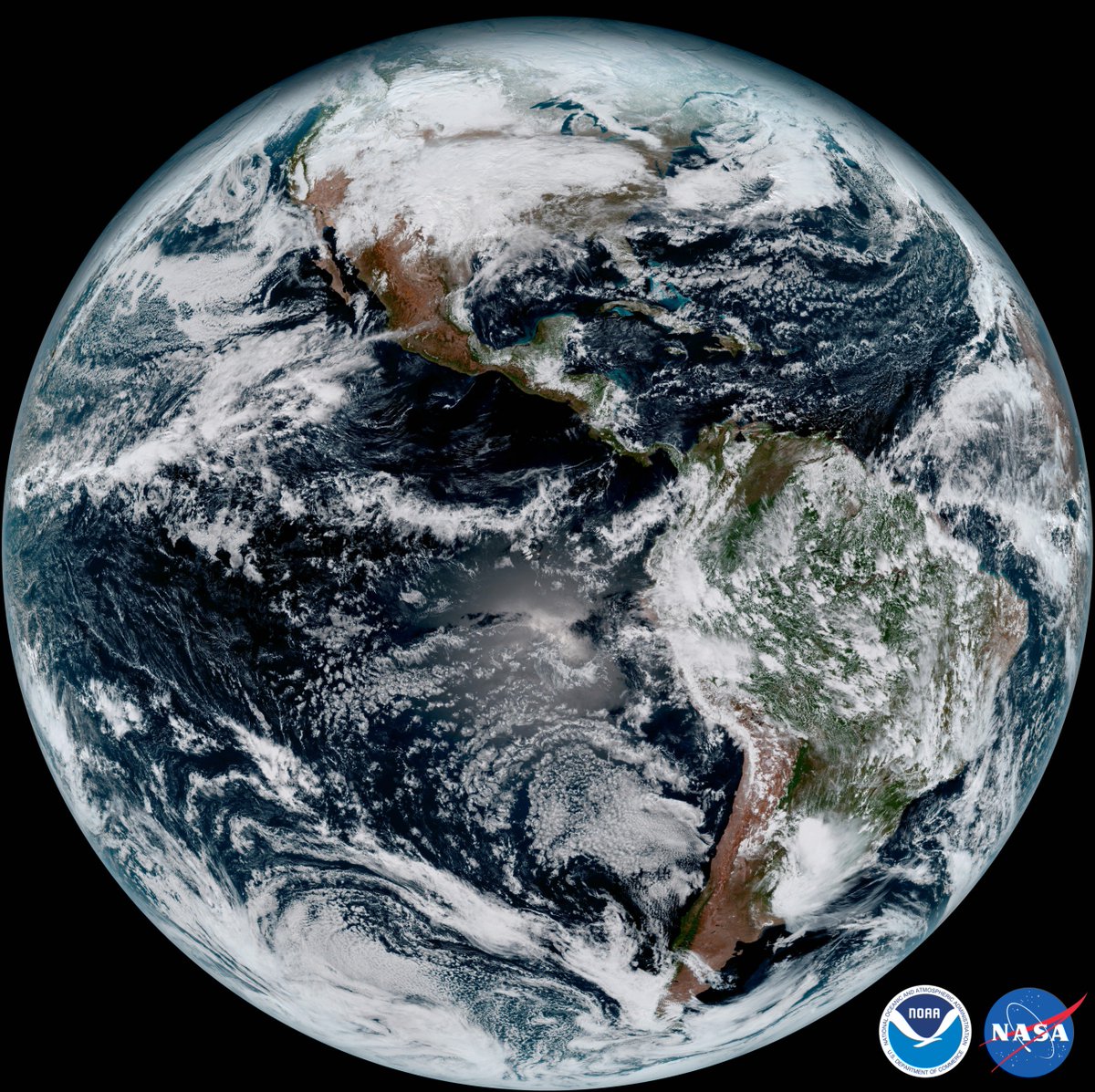
GOES-16 has sent its 1st full disk image of the W. Hemisphere! Learn more about this amazing image & satellite at
52
1K
2K
Happy #FullDiskFriday! Tomorrow at 2:50 am ET, astronomical #autumn officially begins in the Northern Hemisphere!🥳🍂. To celebrate, here is a time-lapse from @NOAA's #GOESEast 🛰️ showing the change in the angle of the sun from last year’s #equinox through today.
30
665
2K
Watch #Irma dissipate in this 72-hour water vapor imagery from NOAA's GOES satellites! See more loops @
31
1K
2K
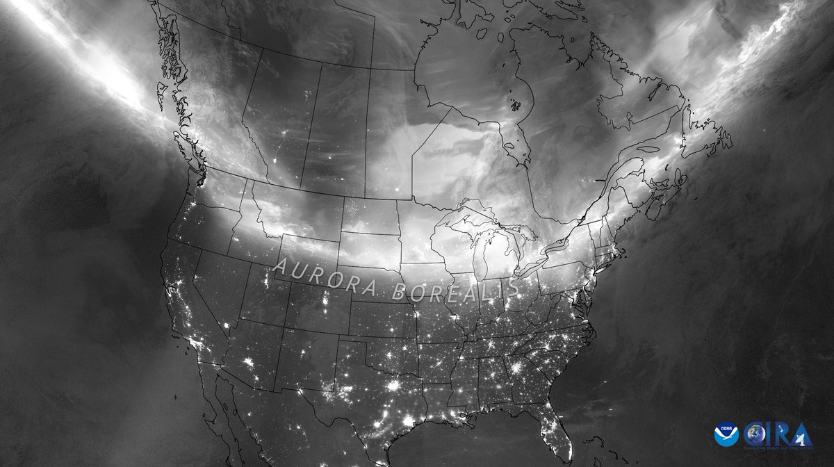
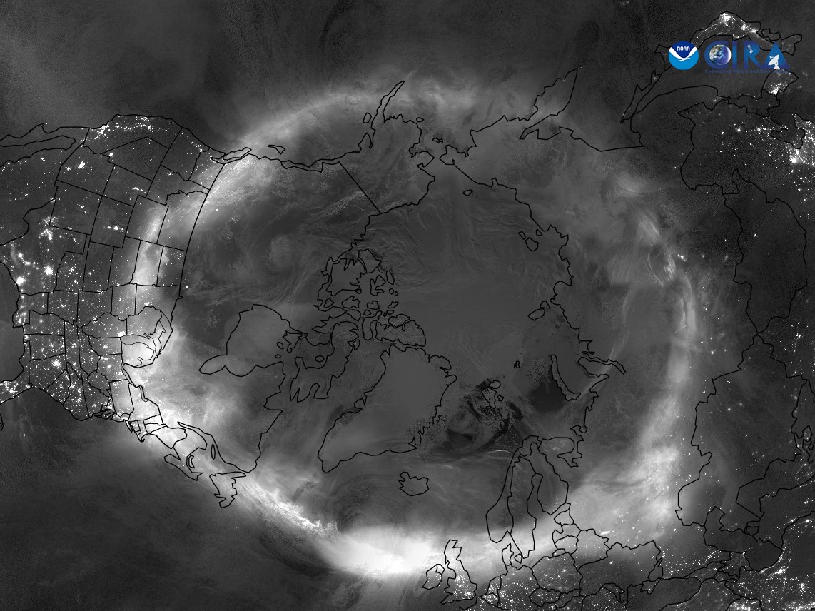
The sun's fiery temperament unleashed multiple coronal mass ejections last week, which ignited a mesmerizing display of #auroras across the globe—even in places where the phenomenon is rarely seen. This combined image was captured by @NOAA's @JPSSProgram satellites as they passed
19
427
2K
#HurricaneMichael intensified as the storm made landfall near Mexico Beach, Florida, at around 1:30 p.m. ET. @NOAA's #GOESEast satellite captured this view of the Cat. 4 hurricane moving ashore. Latest updates from @NHC_Atlantic:
36
1K
2K
.@NOAA's #GOESEast 🛰️ is tracking the extremely dangerous Cat. 4 #HurricaneIda, expected to bring a life-threatening storm surge and #hurricane-force winds to the coast of southeastern #Louisiana today. Updates: .#LAwx #MSwx #Ida #IdaHurricane
46
753
2K
We’ve just received confirmation that #GOEST has executed its final engine burn, and has reached geostationary orbit 22,236 miles above Earth! .It has now been renamed GOES-18! 🎉🛰🌎. Learn more about this milestone in this week’s #EarthFromOrbit:
28
333
2K
#HurricaneOtis was the strongest Eastern Pacific #hurricane to make landfall in the satellite era, and @NOAA satellites were watching . Learn more about #Otis in the latest #EarthFromOrbit video:
23
774
2K
Watch the shadow of the moon darken the West Coast in this 1st #GOES16 #Eclipse2017 loop! See the latest imagery @
30
1K
1K
On Sept. 8, 2020, the #GOESWest 🛰️ focused in on the #OregonFires and #CaliforniaFires. We can not only see all the smoke they produce, but by combining Fire Temperature RGB with this GeoColor imagery, we can see the reddish glow of the hot spots where they originate.
34
912
1K
Around 11:30 p.m. HST last night, @NOAA's #GOESWest 🛰️ captured the eruption of Hawaii's #MaunaLoa volcano, inside @Volcanoes_NPS. This imagery shows the heat signature and the sulfur dioxide released from the #volcano's summit caldera, Moku‘āweoweo.
34
689
1K
This #FullDiskFriday, #GOESEast is continuing to see dust from the #Sahara desert blowing westward over the Atlantic Ocean as well as large amounts of smoke from fires in the #Amazon rainforest. More imagery:
55
746
1K
Here's some #MondayMotivation for you this morning—another view of yesterday's annular #SolarEclipse courtesy of #Meteosat8, operated by our partners @EUMETSAT. This type of #eclipse occurs when the moon passes in front of the sun, but doesn't completely cover it.
27
552
2K
Follow the moon's shadow across the Northern Hemisphere in this loop from #GOES16! See more #SolarEclipse imagery @
15
1K
1K
Hurricane #Florence looks enormous, even from space. Here are three dramatic views of the storm approaching the East Coast, seen from the #GOESEast satellite this morning. Latest updates: #HurricaneFlorence


35
1K
1K
3rd time was a charm! A great day for #JPSS1. Keep watching live coverage; we've got a few milestones to go.
17
341
1K
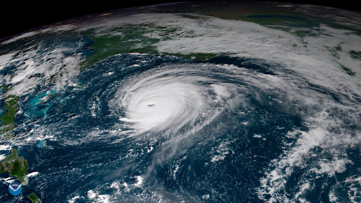
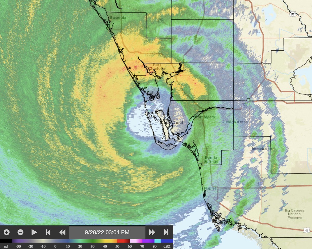
.@NOAA’s #GOESEast satellite captured this extraordinary imagery of #Hurricane #Ian making landfall near Cayo Costa, Florida this afternoon. Latest: #FLwx
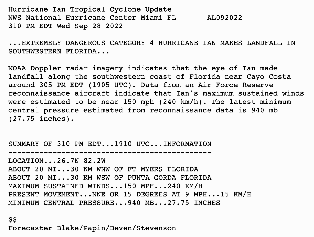
305 PM EDT 28 Sep -- Hurricane #Ian has made landfall as an extremely dangerous Category 4 hurricane near Cayo Costa, Florida with maximum sustained winds at 150 mph. The minimum pressure from Air Force Reconnaissance Hurricane Hunters was 940 mb. Latest:
34
634
1K

The second Geostationary Lightning Mapper to ever reach orbit has shared its first images. This initial imagery from NOAA’s recently launched #GOES17 satellite captures a line of severe storms over the Plains. See the full video:
31
571
1K
The sun set on #HurricaneDorian as it battered the #Abaco and #GrandBahama islands with wind gusts of more than 220 mph today. NOAA's #GOESEast continues to keep watch over the slowing catastrophic Cat. 5 storm. Latest updates:
32
813
1K
Many of Florida's #CoralReefs have been hit with severe bleaching and significant mortality due to extremely warm ocean temperatures, and @NOAA's @CoralReefWatch has been tracking the threat. In this Bleaching Alert animation, you can see how the threat has grown over the last
59
730
1K
Happy Spring #Equinox and happy #firstdayofspring! Today the length of night and day are nearly equal. The days will now become longer at the higher latitudes because it takes the sun longer to rise and set. More satellite imagery:
40
815
1K
#GOESR has successfully separated from the upper stage and is now flying free for the first time!
23
512
1K
For #TimelapseTuesday, this #GeoColor imagery from @NOAA's #GOESEast satellite shows the first 4-days of #Beryl, when the storm grew from a tropical cyclone in the western Atlantic Ocean to a category 5 hurricane in the Caribbean Sea. More on #HurricaneBeryl:
11
464
1K
The #SummerSolstice will occur today at 4:51 p.m. ET in the Northern Hemisphere!. To celebrate the start of astronomical summer, take a look at how the angle of the sun changes from #solstice to #equinox and back again over the course of a year due to the Earth's 23.5° tilt.
16
543
1K
Yesterday marked the #AutumnEquinox, signaling the official start of astronomical #fall in the Northern Hemisphere! . Over the past year, we've gathered a daily image from @NOAA's #GOESEast 🛰️, taken at the same time each day. Together, they show the sun's angle shift over time
16
405
1K
There was #lightning before the #thunder.Thunder, thunder.Thunder, thunder.Thunder, feel the thunder.Lightning and the thunder.Thunder. #GOESEast captured the amazing amount of lightning and #thundersnow in this week's severe storm. More imagery:
28
470
1K
83
1K
1K
Happy #SeaTurtleWeek!. #DidYouKnow that by mapping the migration routes of tagged #loggerhead #SeaTurtles, we can see that they base their course on a specific chlorophyll and temperature gradient? In other words, they prefer more temperate oceans—not to hot and not too cold.
27
425
1K
Watch tonight's sunset over #HurricaneFlorence, captured by the #GOESEast satellite, as the storm draws closer to the East Coast. Latest real-time imagery:
21
743
1K
#GOESR is now GOES-16! The satellite reached geostationary orbit yesterday, November 29, 2016. Read more about it at
31
585
1K
Wondering about the shape of the #blizzard? The powerful midlatitude #BombCyclone has several meso-vortices spinning within its center, #GOESEast ABI captured these images of the storm every minute today. #snowday See more #cool GOES imagery here:
35
748
1K
Happy #TimelapseTuesday and #FirstDayOfSpring! 🌸🐣.The #VernalEquinox occurs at 11:06 p.m. EDT in the Northern Hemisphere, marking the start of #AstronomicalSpring!. This animation shows the angle of the sun changing from last year's vernal equinox through today due to the
11
434
1K
How do @NOAA scientists "see" the #PolarVortex? It's done using data from several different polar-orbiting 🛰️, including #NOAA19. Learn more about the wobbly blob that is the #ImageoftheDay, which shows the vortex from early December to mid-January:
25
443
1K
#GOESEast captured a Fujiwhara Effect off the coast of Chile. This phenomenon occurs when cyclonic vortices revolve around each other to close the distance between circulations of their low-pressure areas. More:
31
765
1K
Wow! #GOES16 captured this imagery of the weekend's powerful storms in the southern Plains & MS Valley. More loops @
36
756
1K

24
591
996
We are back up and running this morning! Thank you for your patience. Please visit us at
24
278
949
.@NOAA's @JPSSprogram polar-orbiting satellites captured imagery of the stunning auroras that were visible in locations across the globe on May 11, 2024. Learn more in today’s #SatelliteSnapshot:
7
276
977
The view of Earth on the day the world lost #StephenHawking, a man who inspired us to reach for the stars. NOAA #GOESEast Full Disk GeoColor satellite imagery, March 14, 2018.
9
428
912
#GOESEast captured the full path of the #BombCyclone exhibiting a rare and extremely rapid rate of intensification on the East Coast with some of the coldest wind chills of the season and near zero visibility in the snow bands @NWS. #Blizzard2018 More:
32
726
941
A rolling dry line in Texas produced severe thunderstorms on May 3, 2021. Common in the spring and summer, dry lines serve as a boundary between moist and dry air. Find out more about how they form and why in #EarthFromOrbit:
16
227
907
#GOESEast got a closer look at the #bombogenesis developing over the Central U.S. during this morning's sunrise. A bombogenesis occurs when a mid-latitude cyclone rapidly (or explosively) intensifies over a 24-hour period. Find out more:
33
511
915

#GOESEast's Geostationary Lightning Mapper (GLM) captured this view of severe weather associated with the #bombogenesis moving into the Lower Mississippi Valley and the Tennessee and Ohio valleys on Thursday. More imagery:
21
400
917
#DSCOVR: We had an on time liftoff and all mission events have occurred on time. Now in 22 min coast phase http://t.co/ODDjAeIOIT.

43
636
920
NOAA's #GOESEast spotted lightning in the eye of #HurricaneDorian this morning. The now catastrophic Cat. 5 storm is expected to bring life-threatening storm surge and very heavy rainfall to the Abaco Islands and Grand Bahama through Monday. More:
24
576
885
#OnThisDay in 2015, @NASA’s Earth Polychromatic Imaging Camera (EPIC) onboard @NOAA's Deep Space Climate Observatory (#DSCOVR) captured this view of the "dark side" of the #moon as it moved in front of Earth. DSCOVR also provides scientists with critical #SpaceWeather data.
11
190
936
The view from #GOESEast shows #Florence still hasn't moved much as the storm slowly slogs inland. Parts of North Carolina have already picked up 20-30 inches of rain, with more on the way. More info: #TropicalStormFlorence
18
614
908
This #TimelapseTuesday, we're looking at sea surface temperatures. As meteorological summer approached, @NOAA's #GOESEast 🛰️ watched the Gulf of Mexico heat up. We can even see the warm "loop current" from the Caribbean Sea flowing into the Gulf Stream in this visualization from
18
336
918
Here @NOAA we have a lot of data. We don’t like to brag. but we have BIG data, ocean data, petabytes of satellite data, we could go on. And we will, HAPPY #DATAPALOOZA DAY!!!! . Do you have cool data too? Celebrate all the data available to science today with the #DATAPALOOZA!
29
270
892
A rare clear image of #Florida today almost completely cloud free from a cooler dryer air mass #WeatherIsCool #StrangerThursdays
13
423
875

Take a look at all that lightning! The Geostationary Lightning Mapper aboard NOAA's #GOESEast captured this view of all the lightning associated with #HurricaneDorian2019 in the morning hours of Aug. 30, 2019. Follow the storm's path here:
31
431
831
In 5 days…Coming to an orbit 22,240 miles from you… #GOESR: @NOAA’s next gen. weather satellite! #Countdowntolaunch
23
436
847
#DSCOVR: Here's a beautiful picture of DSCOVR taking its ride into space after the 6:03pm EST on-time launch. http://t.co/GegGxMSNy2.

25
574
833
Imagery from the Geostationary Lightning Mapper aboard #GOES16 is here & its spectacular! Learn more about the GLM @
29
611
828
#GOES16 time lapse of the 2017 Atlantic #hurricane season so far, one of the most active on record. More imagery @
13
672
843