

Sam Lillo
@splillo
Followers
14,486
Following
892
Media
7,203
Statuses
25,101
Senior software engineer @DTNweather • Ph.D. @UofOklahoma • NWP across scales • Tropical Cyclones • S2S • Dataviz • Python • Tweets are my own
Boulder, CO
Joined June 2010
Don't wanna be here?
Send us removal request.
Explore trending content on Musk Viewer
満塁ホームラン
• 102342 Tweets
#ラヴィットロック2024
• 98301 Tweets
大谷翔平
• 92993 Tweets
Brighton
• 85568 Tweets
花火大会
• 78188 Tweets
#V最協S6
• 65008 Tweets
ALNP FANMEET IN HK
• 56915 Tweets
Vielfalt
• 50277 Tweets
#FNTHWIN
• 46038 Tweets
Täter
• 35981 Tweets
大谷さん
• 33335 Tweets
ケンタッキー
• 33057 Tweets
STRAY KIDS DOMINATE SEOUL
• 31755 Tweets
Slogan
• 28216 Tweets
悪役令嬢の中の人
• 27327 Tweets
CHRISTOPHER
• 18505 Tweets
カミナリ
• 15668 Tweets
Grande Motte
• 14575 Tweets
La Grande-Motte
• 14465 Tweets
韓国の女の子
• 11858 Tweets


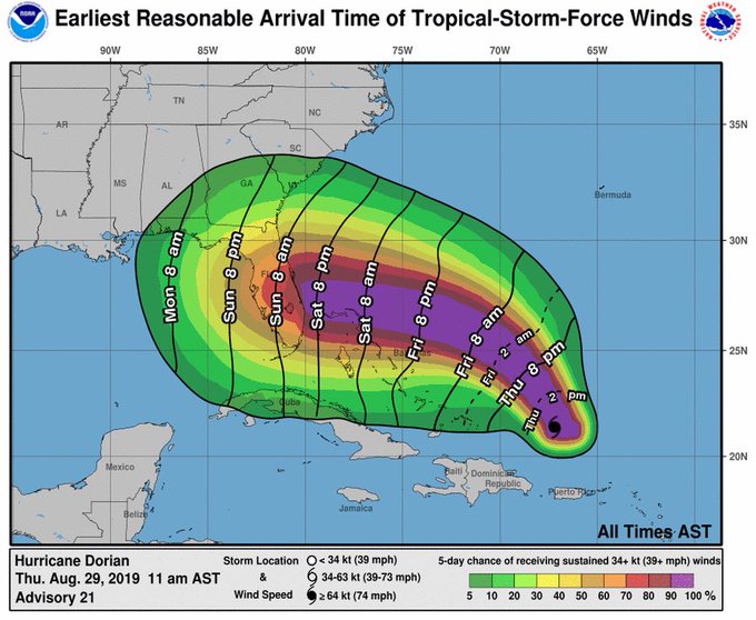
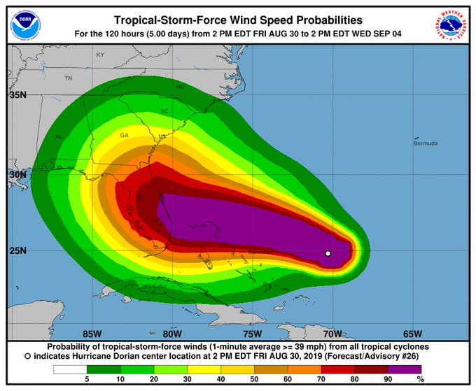
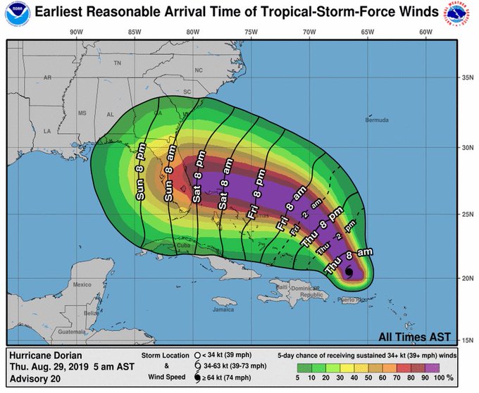
Because the gaslighting is getting real strong now, and it's all too easy to start questioning reality, here is every forecast cone ever drawn by the NHC for
#Hurricane
#Dorian
.
Plus an arbitrarily-chosen state labeled.

249
4K
9K

Pearl St. Boulder, CO on September 8th. It was 97 degrees here two days ago.


68
814
4K
We drove 13 hours to Texas,
and 13 hours back (amazingly zero return traffic),
for a 4-minute experience.
And I do not say this lightly —
it was worth it.

29
99
3K
Every NHC forecast for Ida.
One might say they're pretty good at their jobs.

52
546
3K


Delta just went from 35mph tropical depression to 130mph category 4 hurricane in 30 hours!
I can't find any other storm on record in the Atlantic that has achieved this feat.
The next largest 30-hour intensification from tropical depression is Celia 1970: 35mph to 115mph.
38
532
1K
I was unaware of the existence of this color name, nor did I know this was the color of tornado season.
But am I painting my bathroom this color now? You bet I am.

22
73
1K
Hurricane
#Beryl
intensified from a tropical depression to a 105kt (120mph) category-3 in 42 hours, and 115kt (130mph) category-4 in 48 hours.
Here's how that intensification compares to all tropical depressions on record in the Atlantic.
Unprecedented barely covers it.


16
338
884
In the last 24 hour, Hurricane
#Dorian
intensified from 130kt to 160kt ... in fact it did this in under 9 hours.
Rapid intensification is an impressive enough feat, but becomes extremely rare from high initial intensities. From 130kt, it is unprecedented in the Atlantic.
22
362
758


Here's a map of the amount of time spent in the 5-day NHC forecast cones so far in 2020.
Louisiana has had a cumulative of THREE WEEKS in the cone this year!
And now we have TD 28 tracking toward the same area.

29
274
664

Who honestly believes it's New Years Eve?
It's March 670th, 2020.
7
73
597


Duration of hurricane-force winds in Ian 2022 vs. Charley 2004.
Size and speed matter.


12
106
476
Hurricane Ian intensified by 30kt in 12 hours last night, while already a cat-3/4.
At its location, there's no record of a storm this strong, strengthening *even at all* any further.
Rapidly intensifying major hurricanes at landfall is a terrible theme in the last few years.

12
164
454

Approaching 10 inches of snow with a wind chill sitting at 1 degree right now in Boulder.


17
57
443
Politics aside, it is unacceptable for the President of the United States to be sharing and discussing outdated forecast maps for Dorian while the hurricane is *currently* having dangerous impacts in the Carolinas.

Just as I said, Alabama was originally projected to be hit. The Fake News denies it!

26K
6K
29K
26
97
435
Hurricane Iota has intensified 85 kt (100 mph) in 36 hours.
8 storms have done this in 169 years of records prior to 2020:
Labor Day 1935, Camille 1969, Andrew 1992, Rita 2005, Wilma 2005, Felix 2007, Matthew 2016, Maria 2017
3 storms in the last two months:
Delta, Eta, Iota

12
219
429


Using recon data & satellite center fixes, here are wind duration swaths by category for
#Dorian
, zoomed in on Grand Bahama and Abaco Islands.
As it stalled out, portions of the islands endured:
hurricane-force winds for over 36 hours,
cat 2 for >24 hrs,
cat 3 for 6-12 hours!
14
193
414
I know I've become a broken record, but this is not something you see from a LIM everyday.
Large region of >95% warm probs (*ensemble mean* anomalies of 5C+) at weeks 3-4 lead-time.
The Pacific NW to Intermountain West and N Plains are going to BAKE through to early Sept.

18
142
406

@wxjay
@OUWXDoc
@millennialmitch
we can drop all terminology and just agree the storm "gets wicked strong wicked fast"
6
93
367
At taco bell, the guy behind the counter:
"Weather doesn't really scare me. I've been analyzing the last few days and it hasn't really been all that hot or cold, so I'm not worried about today."
I can't. I almost screamed.
40
23
380
This appears to be one of the best-verified high-end category 4 landfalls ever.
8
31
375
Fact is, this is 7 days out now, with pretty impressive consistency among NWP in producing, in *multiple ways*, an historic East Coast cyclone.
Consider me increasingly intrigued.

31
47
362
At the daily meeting of NWP:
ECMWF - "Okay group, what haven't we thrown at them yet for the end of October?"
CMC - "How about, wait for it, we take a Pacific hurricane and turn it into a Great Lakes blizzard?"
GFS - "I'm on it."
14
96
360
Updated and corrected chart with the latest best track intensity for Hurricane Delta.
This is the intensity trajectory of all tropical depressions in the Atlantic since 1851, with a few familiar outliers labeled, and now Delta, setting new records over the last 12 hours.

11
155
364
#Henri
is expected to slow to a crawl just as it's making landfall in New England. This is exceptionally rare, and has major ramifications with impacts.
The NHC forecast has Henri moving around 5 to 6kts over Rhode Island. The *slowest on record* for a hurricane there is 26kt.


24
157
360
Okay this is something ...
Eta just intensified from 35kt to a 115kt cat-4 in 36 hours.
Let's look at all Atlantic TCs *any time of the year* starting at 35kt or lower.
I did this and saw only ONE storm that was stronger at 36 hours ..... Remember Hurricane Delta?

15
121
358
Colorfill corresponds to density of Snapchats, and also rate of new COVID cases.
RIP Boulder.

7
46
339
For a hurricane that invited a lot of postulating on the forecast track, the NHC was remarkably consistent.
(a thread)

11
113
351

5 years ago today, President Obama dropped by the NHC and participated in the forecast process.
No sharpies were used in this forecast.

10
35
346

Updated map of time spent in NHC 5-day forecast cones in 2020.
Entire US coastline has been covered, most for at least 5 days. Louisiana has spent over 3 weeks in the NHC cone. Eta bumped up the Florida peninsula to over a week.

18
100
340
Satellite views of Teddy this morning are definitely getting saved.

3
51
338


Up to 54 tornado reports now for last Wednesday, and a 45%+ PPH contour has emerged.
Patience.

2
59
327


It’s 2021, with one of the higher-end confidence hurricane forecasts in terms of both track and intensity you could ask for, starting days ago.
This country’s performance in emergency preparedness and response is truly abysmal sometimes.

Cantrell: We don't have the time to implement contraflow. Therefore the city cannot pivot to a mandatory evacuation, because we don't have the time.
#NOLA
216
275
501
20
62
302

Alright here's the historical context for a 50mph (45kt) sub/tropical storm off the coast of Portugal.

15
104
321


Michael will be a category 3 hurricane in Georgia. Making it only the 4th major hurricane in their history. And the other 3 were all in the 1800s.
And it passed over Florida first.
#Michael
could be one of
#Georgia
's strongest
#hurricanes
. And it didn't even make landfall there.
1
25
73
8
170
289


I had a script to plot the distance between Hurricane Iota and Hurricane Eta.
As of 00 UTC, that distance is zero. They are virtually in the same location, 13.5 days apart: Eta a cat 4, Iota a cat 5, a few miles from landfall in Nicaragua.

4
84
296
A hurricane slinky: Track and radius of maximum winds for
#Hurricane
#Dorian
, using the satellite estimates from ARCHER ()
Thanks for the suggestion
@RyanMaue
!

11
81
283
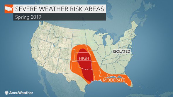
"AccuWeather predicts there will be 1,075 tornadoes in 2019"
You cannot possibly be serious with this.

AccuWeather projects a higher frequency of severe weather risks in the traditional Tornado Alley this season. The states to be impacted the most will include Oklahoma, Kansas, and parts of Texas and Nebraska:
56
151
241
59
33
292
Colorado wind storms are not unusual. But when only an inch of snow falls for the first half of winter with months of record high temps, an extension of fire season is unfortunately unsurprising.
The climate change crisis isn’t just the future, it’s the present.
9
62
287
With the formation of Theta (the 29th named storm, and 8th Greek letter used), the 2020 Atlantic Hurricane Season sets a new record for most storms in a year, beating 2005.

10
130
285


All of the recon flight level wind observations below 600mb so far in 2020: a total of 119,252 points. There have been 237,920 obs including upper levels.
Fastest flight level winds recorded were 148kt (170mph) in Hurricane Laura.
Plot made in collaboration with
@burgwx
.

6
55
282
The points at which Tulane was put under a hurricane watch and hurricane warning, and where the storm was located at that time.
Stop making excuses for your own lack of awareness and preparedness.


6
25
276
Track of Hurricane Laura 6 weeks ago, and the forecast track of Hurricane Delta overlaid.
Current forecast landfall is just 12 miles from where Laura made landfall.

16
139
271
Date of the 75th tornado watch of the year:
2007 April 3
2008 March 8
2009 April 5
2010 May 1
2011 April 10
2012 March 29
2013 April 27
2014 May 11
2015 May 10
2016 May 26
2017 April 21
2018 August 26

8
129
262
Ida and Katrina, two devastating major hurricanes, 16 years and just a few miles apart.

3
98
266
I’m usually never short of words, but all I can say is she said yes, and it was the happiest moment of my life.
I’m so excited for this next chapter of our lives together ❤️


31
4
272


Am I seeing this right, or did the ERC really just happen that quick and smoothly?
13
46
251


Lightning in the northwest quadrant of
#Dorian
. Plus very quick symmetrization of the eyewall now. Assuredly in a period of rapid intensification. Plus heading toward the nocturnal convective max. Really making me wonder what we will be looking at by sunrise tomorrow.
14
94
239
At 12 UTC 9/7,
#Hurricane
#Lee
had an intensity of 80kt. The NHC forecast initialized at this time (for the 15 UTC advisory), brings Lee to Category 5 intensity at 36 hours.
This isn't on the edge of unprecedented — it is a massive outlier in the history of NHC forecasts.

4
78
247

Follow these 3 simple tricks, and you'll never be wrong on a snowfall forecast again!
1) Plus signs after each range — can always be higher!
2) Unlabeled colors — avoid being verifiable.
3) Legend that's inconsistent with other labels — ambiguity is the key to success!

21
11
248
Recon over the four days has done some truly incredible sampling of Hurricane Delta.

6
46
247
"is awarded annually to the most outstanding University of Oklahoma quarterback"

2
71
243
Year and date of all 165kt tropical cyclones on record around the world.

6
71
245
Ida will go down as one of the most impactful hurricanes in US history, from New Orleans to New York.
It also had amazingly accurate and advanced forecasts and warnings.
The past 7 days needs to be a benchmark interdisciplinary case study for sociologists and weather comms.

Any other meteorologists just have ALL the wind taken out of their sails hearing people say the flooding "caught them by surprise"?
@alroker
flagged the tri-state flood risk Sunday & Monday.
A HIGH RISK was issued yesterday. What more can we do? How can we better communicate?
133
64
700
4
48
243
