

Prof. Simon Carn
@simoncarn
Followers
7,194
Following
848
Media
1,358
Statuses
3,217
Volcanologist @michigantech . Satellite-powered analysis of global #volcanic activity. #GreatLakes silent sports 🏃🏻♂️🚵🏻♂️⛷. Often buried in snow. 🇬🇧/🇺🇸
Fresh Coast, MI
Joined April 2009
Don't wanna be here?
Send us removal request.
Explore trending content on Musk Viewer
DEAR MYLOVE LINGORM
• 1093114 Tweets
#Narin
• 182672 Tweets
CHARLOTTE X TIKTOKLIVE99
• 95920 Tweets
#光る君へ
• 81106 Tweets
#FinalMGSBR2025xENGFA
• 55726 Tweets
#レカぺだけ歩こうJO1
• 50736 Tweets
プロジェクトKV
• 42665 Tweets
Zapatero
• 39756 Tweets
İdam
• 24826 Tweets
#鉄腕DASH
• 21083 Tweets
SUNa ALL KAIRAIN
• 19876 Tweets
ポルノグラフィティ
• 19227 Tweets
#ブラックペアン
• 16583 Tweets
#にじカラオケ祭
• 12652 Tweets
Edmundo
• 10498 Tweets
源氏物語
• 10225 Tweets
Kostic
• 10082 Tweets


Pinned Tweet

Another major
#eruption
of
#Ruang
. Geostationary UV
#GK2B
GEMS data nicely capture the spreading
#volcanic
SO₂ cloud, including the
#stratospheric
overshoot drifting rapidly westwards. The SO₂ mass (~0.3 Tg) is very preliminary and needs confirmation from other sensors.

#Ruang
Some (prelim.) analyses. Q~4-5x10^9 m^3/s (2x larger than 17.04.24 eruption). 4<VEI<5. Red: 200 K contour; White dot: min Temp., Black dot: center of enclosing circle corresponding to red contour. Himawari-9 data courtesy JMA/JAXA.
@simoncarn
@ThomasJAubry
@JAXA_en
7
59
144
6
87
183
#Aurora
over
@LakeSuperior
seen from Copper Harbor,
#Michigan
tonight.
@UpperPeninsula
@PureMichigan
#StormHour

13
152
1K
Growth of Anak
#Krakatau
#volcano
since May 2018 from
@planetlabs
imagery. Fairly rapid recent expansion to the south could possibly have caused some flank instability. Still awaiting post-
#tsunami
imagery to assess any changes.
@Sutopo_PN
@vulkanologi_mbg
@id_magma
14
741
849
A
@planetlabs
image timelapse (Dec 24, 2019 - Jan 16, 2020) showing the dramatic changes in the main crater of
#TaalVolcano
after the Jan 12-13
#eruption
.
#TaalVolcanoEruption
#TaalEruption2020
@phivolcs_dost
@nababaha
@EarthUncutTV
@raffytima
10
252
543
The very impressive torrent of lava fed by the Fissure 8 fire fountains at
#Kilauea
, as seen on June 10.
21
312
510


The first
#stratospheric
#volcanic
#eruption
of 2022, at
#HungaTongaHungaHaapai
(
#Tonga
) on Jan 13-14.
#Sentinel5P
#TROPOMI
&
@NASA
's Aura/OMI both measure ~0.05 Tg SO₂ in the
#volcanic
cloud - not enough for
#climate
impacts.
@CopernicusEU
@NASAEarth
@volcanessa
@MetService


14
160
453
Another stunning
@planetlabs
SkySat image of
#AnakKrakatau
on Jan 4. Phreatomagmatic activity is filling in the bay above the vent. Copyright 2019 Planet Labs Inc and h/t
@rsimmon
.
@Sutopo_PN
@vulkanologi_mbg

8
220
435
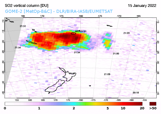
Here are the latest
#Sentinel5P
#TROPOMI
SO₂ data covering most of the
#HungaTongaHungaHaapai
#eruption
cloud (just the western edge is missing). The total SO₂ mass is ~0.4 Tg.
@CopernicusEU
@DlrSo2
@BIRA_IASB
@ESA_EO
@esa

17
138
348
An
#eruption
has started on
#Iceland
's
#Reykjanes
peninsula (north of
#Grindavik
) with some impressive lava fountains. Follow
@Vedurstofan
for official updates.
Webcams:
7
162
339
Apocalyptic wall of fog over
@LakeSuperior
about to engulf Copper Harbor, MI at 9 pm on July 1. Photo by Steve Brimm.
#MIwx

3
76
310
#Facts
about volcanic CO2:
1) Measurements show that global volcanic CO2 emissions are ~0.01% of human emissions.
2) Carbon isotope data confirm that the increase in atmospheric CO2 since 1850 is of biogenic (i.e., fossil fuel), not volcanic origin.

This volcano just spewed more CO2 than every car driven in history. Climate change is natural. Taxing us into poverty isn’t the answer.
3K
29K
82K
7
137
295

3
242
257
One of my all-time favorite
#volcanic
cloud images - the mammatus-ash cloud from the May 18, 1980
#MtStHelens
#eruption
advancing over Ephrata, Washington
#OnThisDay
39 years ago. Photo by Douglas Miller.

6
94
271
Large
#eruption
of
#Shiveluch
(#Шивелуч,
#Kamchatka
) w/ stratospheric plume, starting at ~12:00 UT on April 10 with paroxysmal phase at ~17:00 UT.
#Sentinel5P
#TROPOMI
measures ~0.2 Tg SO₂ in the
#volcanic
cloud. Looks like the largest Shiveluch eruption of the satellite era.

11
107
255
A sequence of preclimactic explosions that would culminate in the June 15, 1991
#Pinatubo
#eruption
(
#Philippines
) began
#OnThisDay
30 years ago. These well-known
@phivolcs_dost
and
@USGSVolcanoes
photos show the June 12, 1991
#eruption
; a major event in its own right.


2
66
242
Merry
#Christmas
to all!
Thanks to all the folks keeping watch over the world's active
#volcanoes
during the holiday season.

3
32
236
SO₂ emissions from the April 16
#eruption
of
#Ruang
#volcano
(
#Indonesia
) measured with hourly cadence by
#SouthKorea
's
#geostationary
UV GK-2B
#GEMS
sensor. Relatively low SO₂ amounts detected so far.
@PVMBG_
@id_magma
@andrewcraigtupp
6
93
239
#Eruption
of
#HungaTongaHungaHaapai
#volcano
in
#Tonga
on Dec 20 at 20:30 UTC.
#GOESWest
(
#GOES17
) images show water/ice-rich
#volcanic
cloud and lightning detected by
#GLM
. Some SO₂ also being detected by UV/IR sensors.
@Eruptn
@MetService
@MichaelFieldNZ
@NOAASatellites
7
90
230
From cinder cone to tuff ring. Remarkable changes at
#AnakKrakatau
#volcano
(
#Indonesia
) between December 2018 and January 2019, as observed by
@planetlabs
.
Images Copyright 2018-19 Planet Labs Inc.
5
109
227
Each year, several
#volcanic
eruptions produce SO2 emissions detected by satellites. However, to have a measurable effect on global climate, an eruption must:
1. Occur in the tropics
2. Reach the stratosphere (>17 km)
3. Emit at least ~5 Tg SO2
@NASA
@NASAEarth
@NASANPP
7
163
226
Another spectacular
#eruption
of Hunga
#Tonga
-Hunga Ha'apai at ~04:00 UTC on Jan 15.
#Himawari8
data via
@CIRA_CSU
.
11
82
219
The most recent explosion at ~05:00 UTC looked stronger & generated significant lightning - seen here in
#GOES16
IR data with GLM Energy Density. Per
@NEMOSVG
, this event seems to have caused an island-wide power outage (perhaps due to the lightning).

Massive power outage following another explosive event at La Soufriere Volcano. Lightning, thunder and rumblings. Majority of the country out of power and covered in ash
#lasoufriereeruption2021
#explosion
# rumblings
#poweroutage
#
16
467
480
9
135
203
Declassified Keyhole (KH) satellite system KH-9 (Hexagon) military intelligence photos of
#MtStHelens
before (Sept 5, 1973) and after (June 30, 1980) the May 18, 1980
#eruption
. Images are not perfectly aligned due to uncorrected distortion.
#MSH40
@USGSVolcanoes


2
76
210
Radar images from
#Sentinel1
seem to confirm a partial collapse of the
#Krakatau
#volcanic
edifice. The images might also have captured the tsunami wave spreading out from the caldera.
@CopernicusData
@Sutopo_PN
@vulkanologi_mbg
@id_magma

In Sentinel-1 image of Krakatau (Dec. 22, 2018, 22:33:45 UTC), somethings are captured. by
@sentinel_hub
#EarthObservation

9
246
270
6
157
202
The
#eruption
will be televised. It has to be said,
@mblfrettir
and
@RUVfrettir
are really spoiling us with the webcams at
#Geldingadalir
,
#Iceland
. A front-row seat to active basaltic volcanism.
5
45
192
An
#eruption
of the submarine East
#Epi
#volcano
(
#Vanuatu
) started on February 1. Potential post-
#iavcei2023
field trip?
@Eruptn
@scronin70
@KristenFauria
@iavcei2023
@IAVCEIsubmarine

A submarine volcano located between the islands of Epi and Paama has awoken. Ships are being re-routed and the local population is on alert.


17
281
718
9
41
188
#FallColors
advancing on Mt. Houghton, a billion-year old rhyolite
#volcanic
dome near the tip of
#Michigan
's
#Keweenaw
peninsula and
@LakeSuperior
.
@PureMichigan
@UpperPeninsula
#PureMichigan
@KeweenawNPS

2
26
184
Awesome tool by
@anvaka
for making 'ridgeline' topographic maps in the style of Joy Division's iconic Unknown Pleasures album cover:
Here's
#Java
,
#Indonesia
- it's fun to identify all the
#volcanoes
. A simple yet compelling way to visualize topography.

5
64
176
An
#eruption
of
#Nyiragongo
#volcano
(
#DRC
) began in the evening of May 22.
#Meteosat
satellite data (from
@CIRA_CSU
) show a strong thermal anomaly appearing at 17:15 UTC, and a small
#volcanic
plume amidst widespread regional convection. Follow
@CharlesBalagizi
for updates.
4
92
174
These
@planetlabs
images of
#AnakKrakatau
on Dec 30 suggest that its crater lake is almost gone; filled in by new tephra and lava as the cone regrows.
@id_magma
@vulkanologi_mbg
@infomitigasi
@CopernicusEMS
@OysteinLAnderse
@EarthUncutTV
Copyright 2019 Planet Labs Inc.


4
98
172
The
#LaSoufri
ère
#eruption
continues overnight on April 10-11. Explosive events are occurring with a notable periodicity; every ~1.5-2 hours. This
#GOES16
SO₂ RGB imagery (
@CIRA_CSU
) also shows that these explosions are still producing SO₂ (red).
@uwiseismic
@soufriere_hills
4
108
171
Just in - new
@CopernicusEU
#Sentinel1
VH radar image of
#Nyiragongo
and
#Goma
on May 25 showing the flank
#lava
flows erupted on May 22 (pre-eruption image is from May 19). Upper flows appear to originate near the Shaheru crater on the S flank of Nyiragongo.
@VirungaSupersit
10
66
166
First 🛰️ look at SO₂ emissions generated by the 2020
#Kilauea
#eruption
, detected by
#Sentinel5p
#Tropomi
on Dec 21. Coverage of the plume is incomplete, but SO₂ amounts look similar to those measured in the early stages of the 2018 eruption.
@USGSVolcanoes
@CopernicusEU

3
44
158
Re:
#NukeTheHurricanes
,
#volcanoes
sort of already tried that. The June 15, 1991
#eruption
of
#Pinatubo
(
#Philippines
), perhaps roughly equivalent to a ~100 Megaton blast, occurred as Typhoon Yunya made landfall. The typhoon was unmoved.

3
72
157
My photos won't win any awards, but there was some nice
#AuroraBorealis
visible from
#Hancock
,
#Michigan
tonight.
#northernlights
@StormHour
@PureMichigan
@KeweenawNPS
@UpperPeninsula


6
22
157
🔊Sound on!
Hear
#Raikoke
's roar - Himawari satellite imagery of the June 21
#Raikoke
#eruption
(from
@CIMSS_Satellite
) with time-synched remote infrasound (from Robin Matoza at
@ucsantabarbara
) sped-up to be audible to humans.
@C_MarieSmith
@volcano_diana
@CIDER_DeepEarth
11
51
150
.
@planetlabs
delivers again with another clear shot of
#AnakKrakatau
on January 7. The evolution of the island continues: a crater lake has formed (perhaps below sea level, difficult to tell) - but how long will it last?
@Sutopo_PN
@vulkanologi_mbg
Copyright 2019 Planet Labs Inc

3
89
151
Some of Earth's newest real estate produced by the August 13
#eruption
of
#FukutokuOkanoba
#volcano
(
#Japan
). These spectacular
@planet
🛰️ images are from Aug 14-15. It'll be interesting to track the voyage of the pumice raft in the coming days.
Copyright 2021 Planet Labs Inc.


1
55
147
It has been 30 years since
#Pinatubo
, the most recent
#volcanic
#eruption
to impact
#climate
.
@NASA
and the
#volcano
science community are preparing for the next one.
@NASAGoddard
@michigantech
@AmericanU
@RiceUniversity
@uoregon
@NASAEarth
@theAGU

5
52
140


2
83
137
Zoom view of 1-minute
#GOES16
data for the ~10:30 UT/April 13
#LaSoufri
ère explosion (
@UWSSEC
GeoSphere). Two lobes of ash emerge below the upper-level ash plume to the N-NW; these are probably the column-collapse PDCs observed by
@NEMOSVG
&
@uwiseismic
.
;
4
73
141
The latest
#eruption
in
#Iceland
has produced the largest
#volcanic
SO₂ cloud measured to date in the 2023-24
#Reykjanes
Fires, consistent with reports that it is the most intense episode so far.
Data:
@CopernicusEU
#Sentinel5P
#TROPOMI
.
@Vedurstofan
@rockhardIES
@Alberto_Carac

2
59
139
Stunning 1st
#volcanic
SO2 image from
#Sentinel5P
#tropomi
! Incredible detail in the
#Agung
plume. This will be a game changer for monitoring volcanic and anthropogenic SO2. Many congrats to
@PepijnVeefkind
and the
#tropomi
team for a successful 1st light.

6
90
136
Impressive, SO2-rich plume from
#eruption
of
#Raikoke
#volcano
(Kuril Islands) spreading across the North Pacific on June 22.
#Sentinel5P
#Tropomi
data indicate ~0.3 Tg SO2 but eruption is ongoing. SO2 columns up to ~1000 DU in the plume.
@CopernicusEU
@airesEO
@SmithsonianGVP

2
61
134
Ongoing
#eruption
of
#Ulawun
#volcano
(
#PapuaNewGuinea
) clearly detected amid tropical convection by the
@JMA_kishou
#Himawari8
SO₂ RGB product (yellow/orange = upper-level SO₂). Emissions continuing as of 15:40 UTC/Nov 20. Largest Ulawun eruption since 2019.
Credit:
@CIRA_CSU
5
53
131
While spacecraft watched the Earth by night (and day)...
A review of some notable
#volcanic
#eruptions
and activity as observed from space in 2021. Happy New Year to all, and thoughts with anyone impacted by volcanic activity in the past year. 🛰️🌋🧵
3
33
136
Latest
#Sentinel5P
#Tropomi
SO2 data shows relatively small SO2 emission from the
#Krakatau
#eruption
(~0.025 Tg). Much too low for any climate impact. Coupled w/ intense lightning & ice/water-rich plume suggests a 'wet' eruption with significant magma-seawater interaction.

2
81
126


To mark the 40th anniversary of the May 18, 1980
#MtStHelens
#eruption
, a thread of some photos from the region. A spectacular
#volcanic
landscape and testament to the enduring impacts of explosive eruptions.
#MSH40

3
38
125
Literally all I do as a volcanologist:
No.
Maybe.
No, Yellowstone won't erupt next week.
No, volcanoes aren't causing climate change. Honestly. we checked.
No.
Ooh, there's that gif of the 2009 Sarychev eruption again.
No.
It's not smoke.
Why do you read the Daily Express?

Literally all I do as a meteorologist:
No.
No.
Flooding is possible, but not likely
264 hour model hurricane forecasts are usually wrong.
No.
It usually doesn't snow here.
No.
The Euro nailed Sandy.
Phone app forecasts suck.
No.
I can't forecast your wedding 1 year out.
No
15
63
708
3
15
123
The
#Sentinel5P
#TROPOMI
overpass at 14:32UT on Sept 19 detected SO2 emissions over the
#CumbreVieja
region at the onset of the
#LaPalma
#eruption
(
#CanaryIslands
).
@CopernicusEU
@BIRA_IASB
Follow
@involcan
and
@IGNSpain
for official updates on
#volcanic
activity.

3
45
126
@janinekrippner
@volcano_ben
Some time ago I compiled a list of
#volcanic
gas-ring sightings. Etna is probably the most prolific source, but they may be common at basaltic, open-vent
#volcanoes
& have been seen at
#Stromboli
,
#Manam
,
#Pacaya
,
#Villarrica
,
#Popocatepetl
,
#Kiluchevskoi
, and
#BatuTara
.


5
57
119
A 1990 bathymetric survey of
#Krakatau
showed how Anak Krakatau is built on the margins of the ~250 m deep 1883 caldera; a potentially unstable location. Tsunamis generated by collapse of the growing edifice remain a significant hazard.
#VolcanoCup

2
114
115
The westward transport of the SO₂ cloud from
#Tonga
confirms that most of the gas is in the stratosphere, where the winds are easterly. Need to wait for
#Sentinel5P
#TROPOMI
,
@JPSSProgram
OMPS or
@NASA
Aura/OMI data to estimate SO₂ mass.
6
24
118
Clear Landsat 🛰️ images of the Keweenaw on June 21 show the Portage Canal slowly clearing as sediment from recent floods is flushed out into
@LakeSuperior
to the north.
@USGSLandsat
@michigantech
@mtugeomining
@kreport


2
60
118
Lava lakes are red
Crater Lake is blue
Eruptions can change climate
If there's enough SO2
#ScienceValentines
#ScienceValentine
0
21
118
The unusual sound of sailing through a sea of volcanic glass - the marine analog of flying through a volcanic ash cloud (but less hazardous). Probably highly abrasive and not good for the paintwork..

🔴 Vídeo muestra una gran cantidad de ceniza cubriendo el Océano Pacífico. Posiblemente por la erupción volcánica submarina en
#Tonga
🇹🇴 que se mantiene desde el 8 de agosto.
Créditos: Rachel Makie 📷
This could help.
@geoign
@simoncarn
@SmithsonianGVP
and
@janinekrippner
13
304
504
5
59
116
Significant damage to coastline NW of
#Palu
#Sulawesi
(near 0.8ºS, 119.8ºE) seen in these
@planetlabs
images from Sept 28 and 29.
#PaluTsunami
(Images Copyright 2018 Planet Labs Inc.)


3
101
108
Of course, the benchmark for
#volcanic
mammatus is the 1980
#MtStHelens
(Lawetlat'la)
#eruption
, 41 years ago this week.
📷 Doug Miller (Ephrata, WA)

0
27
117


0
20
109
Two spectacular Kuril Islands
#volcanic
eruptions seen from the
@Space_Station
, ~10 years apart. Sarychev Peak in June 2009 and
#Raikoke
in June 2019.


0
52
108

First
#Sentinel5P
#TROPOMI
overpass ~1.3 hours after the onset of today's
#eruption
on
#Iceland
's
#Reykjanes
peninsula shows very high SO₂ column amounts in plume spreading SE. Est. SO₂ emission rate is ~1400 kg/s (~120,000 tons/day).
@Vedurstofan
@CopernicusEU
@rockhardIES

2
40
112
#VolcanoCb
and
#volcanic
ash cloud and detected spreading east from
#LaSoufriere
in latest
#GOES16
imagery from the
@NOAA
/
@UWCIMSS
VOLCAT system.


2
40
102
Scary
#volcano
fact for
#Halloween
🌋. While the clickbait media focuses on places like
#Yellowstone
, which is very unlikely to erupt in our lifetimes, there are many genuinely dangerous volcanoes worldwide with only rudimentary monitoring, or none at all.

2
32
103
Good work by the
@TheEconomist
here. Only 15 orders of magnitude off on the CO₂ mass units.

8
23
106
Explosive
#eruption
of
#Lewotolo
(
#Lewotolok
)
#volcano
, E.
#Indonesia
, at 01:50 UTC on Nov 29. Rapidly identified by the
@NOAA
/
@UWCIMSS
VOLCAT system due to strong thermal signal and vertical Cloud Growth Anomaly (
#VolcanoCb
) in
#Himawari
imagery. Max ash cloud height >12 km.
4
36
104
The largest
#eruption
on record of
#Kanlaon
/
#Canlaon
#volcano
(
#Philippines
) on June 3 produced an upper tropospheric SO₂ cloud (~0.05 Tg SO₂), seen here from
#geostationary
orbit by
#SouthKorea
's UV
#GK2B
#GEMS
sensor.
@phivolcs_dost
@News5PH
@nababaha
5
54
105
Good
@NASA
OMI overpass of
#Kilauea
on May 19 showing SO2 plume. Estimated SO2 fluxes based on this data are ~10-30,000 tons/day, which is up to ~5 times the long-term average SO2 flux. Periods of higher flux may correspond to more vigorous lava fountaining.
@USGSVolcanoes

3
61
100
1
8
102
Clear skies over the Sunda Straits provided another great
@planetlabs
capture of
#AnakKrakatau
#Indonesia
on Feb 1. Comparison w/ Jan 12 img shows no major change to crater lake; but slightly modified coastline (prob. wave action on tephra?) & white fumarole deposits.
@Sutopo_PN
2
51
100
Beautiful
@planetlabs
image of Ureparapara in the Banks Islands, northern
#Vanuatu
. William Bligh charted it during his 1789 voyage from Tonga to Timor after the Mutiny on the Bounty. Its breached crater forms a fine natural harbor (Divers Bay).
Copyright 2019 Planet Labs Inc.

6
19
98
Impressive
#eruption
plume from
#Sinabung
today, to tropopause level or higher. But satellites are only detecting modest amounts of SO2: ~11 kilotons in this
@NASA
AIRS retrieval. Much too low for any climate impact.
@ClimateOfGavin
@PabloSurGames
@airesEO

5
57
103
#Kilauea
#eruption
plume update. Latest
#GOES17
imagery (
@CIRA_CSU
GeoColor) shows NE trade winds weakening & the
#Halema
ʻumaʻu plume drifting N of Kilauea. Vog (haze) visible in the
#Hawaiian
eddy downstream. NE trades forecast to return on Thurs.
@USGSVolcanoes
@NWSHonolulu
2
23
101
3
15
101
I spy with my microwave eye. Nice
#Sentinel1
radar overpass of
#AnakKrakatau
on April 15 penetrates the
#volcanic
plume & clouds to reveal the April 10
#eruption
products. Looks like a lava flow and/or other deposits have smothered the pre-existing crater lakes.
@CopernicusEMS
4
41
99
Still the largest
#volcanic
SO₂ cloud measured in the satellite era. Data from
@NASA
's Total Ozone Mapping Spectrometer (TOMS) instrument.
#Pinatubo
#Philippines
@NASAEarth

On this day 32 years ago, Mt. Pinatubo erupted. It is the second largest volcanic eruption of the 20th century, causing damaged crops, mud flows, widespread ash fall, and clouds of volcanic ash which spanned miles across.

1
337
2K
3
29
97
Latest
@CopernicusEU
#Sentinel1
#radar
🛰️ imagery showing continued
#lava
dome growth at
#LaSoufri
ère
#volcano
(
#StVincent
). Most recent image is from Feb 17.
@uwiseismic
@scarlett_jazmin
@sentinel_hub
@soufriere_hills
@mvoms
@VincieRichie
0
27
99
Update on SO₂ emissions from the
#Kilauea
#eruption
on Dec 22.
#Sentinel5P
#Tropomi
🛰️ data show a strong
#volcanic
SO₂ plume wrapping around to the
#Kona
side of the
#BigIsland
, with more diffuse SO₂ further downwind.
@USGSVolcanoes
@Volcanoes_NPS
@NWSHonolulu
@Hawaii_EMA

3
35
90
Here's a look inside the
#Nyiragongo
#crater
(
#Sentinel1
VV data; May 13-25). Looks like a substantial intra-crater collapse has occurred.
@sentinel_hub
@smetsbenoit
@CharlesBalagizi
4
43
91
Some notable 🌋
#eruptions
of the decade:
2010 Eyjafjallajökull🇮🇸
2011 Nabro🇪🇷/C. Caulle🇨🇱/Grimsvötn🇮🇸
2012 Copahue🇨🇱🇦🇷/Tolbachik🇷🇺
2013 Paluweh🇮🇩
2014 Kelut🇮🇩/Holuhraun🇮🇸/Fogo🇨🇻
2015 Calbuco🇨🇱
2016 Bogoslof🇺🇸
2017 Agung🇮🇩
2018 Ambae🇻🇺/Kilauea🇺🇸/Fuego🇬🇹/Krakatau🇮🇩
2019 Raikoke🇷🇺
5
34
90
After the GEMS measurements, there was a major escalation of the
#Ruang
#eruption
, producing a high-level umbrella cloud. Higher SO₂ emissions are expected, with stratospheric injection likely. For reference, the 2002
#Ruang
eruption emitted ~0.1 Tg SO₂.

An explosive eruption of the Ruang volcano occurred just hours ago in Indonesia.
Himawari-9 captured a view of the powerful eruption.
10
453
1K
4
26
93
A few
#volcanic
circles for
#PiDay
. From calderas and craters to bubbles in magma, circles and spheres are ubiquitous in
#volcanology
.
Satellite images copyright 2018-19
@planetlabs
Photo of 1969 Mauna Ulu lava lake, Hawaii from
@USGS


2
28
89
#Sentinel5P
#Tropomi
measures ~0.17 Tg SO2 in the volcanic cloud produced by the
#TaalVolcano
#eruption
, similar to AIRS data reported by
@airesEO
. No climate impact expected from this amount of SO2.
@CopernicusEMS
@phivolcs_dost
@nababaha
#TaalEruption2020
#TaalVolcanoEruption

3
46
87
'Those grand freshwater seas of ours,-Erie, & Ontario, & Huron, & Superior, & Michigan,-possess an ocean-like expansiveness; and for leagues and leagues are flanked by ancient and unentered forests'
--Herman Melville, Moby Dick
📷
@LakeSuperior
from Bare Bluff
@UpperPeninsula

1
15
86
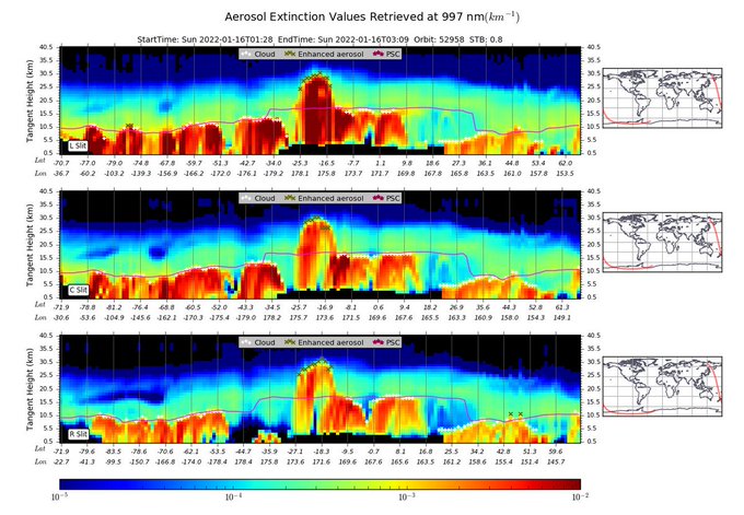
@NASA
@NOAA
@JPSSProgram
SNPP/OMPS limb-profiler (OMPS-LP) aerosol vertical profiles from Jan 16 shown below captured the stratospheric
#volcanic
aerosol cloud reaching altitudes up to ~30 km (in same location as the highest SO₂ columns). h/t
@NASAGoddard
Ozone & Air Quality team
2
39
86
Aftermath of
#eruption
of
#Ulawun
#volcano
(
#PapuaNewGuinea
) captured in
@planetlabs
imagery on June 26. Pyroclastic flows up to ~7 km from the vent on the SE flank and ashfall to the west.
@BrendanVolc
@EmmaLiu31
@SmithsonianGVP
@andrewcraigtupp
@eruptionsblog
@janinekrippner
1
46
87
Possibly significant
@planetlabs
obs of pre-collapse
#AnakKrakatau
from Sept-Oct 2018. Images below:
Sep 29: ash plume from summit of cone
Oct 3: reddish plume from vent lower on SW flank
Oct 8: Notable fissure (?) btw summit and flank vents
Copyright 2018 Planet Labs Inc.


2
28
88
The 'orange tide' from
#AnakKrakatau
is cryptic volcanic degassing. Before its Dec 2018
#eruption
, the
#volcano
emitted several 100 tons/day of SO2. Now, that magmatic gas is dissolving in water, creating hot, acid fluids that precipitate iron hydroxide on entering the ocean.

Today’s
#Sentinel2
🇪🇺🛰 acquisition over
#AnakKrakatau
Orange iron hydroxide precipitation reveals underwater eruptive activity


3
74
154
4
39
84
Updated the
#GOESEast
animation of
#LaPalma
on Oct 1 (13:00-18:30 UTC) as the gravity waves generated by the
#CumbreVieja
#eruption
column are spectacular.
3
30
82