

Kenneth Field
@kennethfield
Followers
23,469
Following
101
Media
7,215
Statuses
37,724
Cartography is my passion & profession. Author of CARTOGRAPHY. & THEMATIC MAPPING. Maps+drums+beer+snowboards+footy+politics+sarcasm. 🇬🇧 in 🇺🇸. Views mine.
Front room, Redlands CA
Joined February 2009
Don't wanna be here?
Send us removal request.
Explore trending content on Musk Viewer
#EURO2024
• 606524 Tweets
Kroos
• 533608 Tweets
Ronaldo
• 505175 Tweets
Portugal
• 496736 Tweets
España
• 495002 Tweets
Project 2025
• 470100 Tweets
Spain
• 371140 Tweets
Mbappe
• 307544 Tweets
Alemania
• 206176 Tweets
Pedri
• 173108 Tweets
رونالدو
• 125072 Tweets
Eurocopa
• 120956 Tweets
Francia
• 115916 Tweets
#PORFRA
• 105290 Tweets
Carvajal
• 103866 Tweets
اسبانيا
• 101393 Tweets
joao felix
• 96752 Tweets
المانيا
• 90142 Tweets
Morata
• 78626 Tweets
Cucurella
• 73817 Tweets
#FRAPOR
• 64719 Tweets
Dani Olmo
• 53231 Tweets
フランス
• 50035 Tweets
Thuram
• 47685 Tweets
スペイン
• 47538 Tweets
Anthony Taylor
• 45081 Tweets
#البرتغال_فرنسا
• 41593 Tweets
Leao
• 33828 Tweets
Kolo Muani
• 33448 Tweets
Dembele
• 30881 Tweets
Deschamps
• 27467 Tweets
Barcola
• 26658 Tweets
كروس
• 26184 Tweets
كريستيانو
• 25293 Tweets
Jota
• 23231 Tweets
كره القدم
• 21647 Tweets
Maignan
• 20827 Tweets
ポルトガル
• 18597 Tweets
Vitinha
• 17877 Tweets
ロナウド
• 11208 Tweets
Nuno Mendes
• 10943 Tweets
كانتي
• 10752 Tweets
Giroud
• 10023 Tweets


Pinned Tweet

If you're here to see my maps, writings, talks, resources etc then visit .
My books are available at .
Feel free to stay for various rambling thoughts (mostly) about
#cartography
.
Also on Bsky and Threads using the same handle.

4
3
27
Fair bit of data wrangling but finally...a 1 dot = 1 vote dasymetric dot density 2016 Presidential election map from
@ArcGISPro
. 65,844,61 blue dots. 62,979,636 red dots. Count 'em! (note: this is just a rough screengrab, will webify & make pretty)

334
4K
9K
The National Library of New Zealand pulled out the world's largest atlas "Earth Platinum" for
#geocart2022
delegates. Wonderful rare opportunity to get up close with this spectacular piece of work and its chief cartographer Roger Smith on hand to discuss its creation.
34
348
2K
Possibly the first time a 3D chart has ever worked.

6
411
1K

In response to suggestions: my
#Ukraine
refugee dispersal map which adds negative space in the colour fill within the border to reinforce idea of displacement into neighbouring countries (and a note about dots being indicative).
More dramatic but perhaps too much?
#cartography

28
127
636
Update to my illustrative
#Ukraine
refugee map.
Adds more displaced grey dots to major populated areas.
Adds same stippled symbology to Russian incursion to indicate fuzziness of invasion (neither lines nor areas).
#cartography
#StandWithUkraine
💙💛

16
130
464
I'm about to launch at ten part thread on making
#maps
of
#Coronavirus
. Hang on to your
#COVID19
facemasks 0/10

10
177
434
Final attempt to map
#Ukraine
refugee crisis more empathetically through permeable borders ???
No arrows
No symbol units
Indicative quantity
Relative densities
Random placement
More organic
Greater spread = more
Colour = Ukranian diaspora
Outward flow & dispersal
#cartography

25
62
377
Couple weeks ago I mentioned I'd heard some terrific news. I can now share.
My long-awaited (by me at least) new book
#ThematicMapping
is being released soon by
@esripress
.
You can peruse a flipbook preview here:
Excited as I am? Let me know!
#EsriUC

26
63
370
"If I do a job in 30 minutes, it's because I spent 10 years learning how to do that in 30 minutes. You owe me for the years, not the minutes" certainly resonates with respect to
#cartography
. Experience & expertise counts for a lot. It's worth a lot too.
8
87
360
#mapsathome
Pocket Atlas of Remote Islands by Judith Schalansky is just the most delightful of books. Beautiful maps, layout and whimsical details.


9
50
332
So
@HamillHimself
has liked 2 of my tweets. I represent a galaxy-busting 0.001% of all his likes but I bet he doesn't remember
#ILikedTheTweet

I just realized I've "liked" over 178,000(!) things on Twitter since 2010. I have never liked even close to that many things in real life, which is too bad, because if I had, I think I'd be a much happier person.
#PleaseLikeThisTweet
1K
6K
98K
15
7
310
I really like this
@BBCNewsGraphics
chart of new confirmed
#coronavirus
cases. Spatial and temporal trends in a well organised visual system. No map is often the best map.

5
81
325

I'm genuinely proud as punch to share that my new book
#cartographybook2
is called
#thematicmapping
. Published by
@esripress
coming VERY soon. Thematic mapping: 101 inspiring ways to visualise empirical data. One dataset. Multiple maps and visualisations
#thisismytruthtellmeyours

15
37
299
Please, no-one make any great maps before the end of the month because I just posted my annual favourite maps of the year blog:
#cartography
#gischat
#maps
#dataviz


3
28
265
So I just did this. An idea I had a year ago. My cheese board of the UK. 26 classic/rare geolocated cheeses with help from
@1_Kidney_Col
& nieces. A time limited, edible map now being eating at
#geomob
#ukmappingfestival
#geocheese


16
40
259
Beautiful map, and I don't just mean 'pretty'. Disentangles small area congestion with what I'd call localised Dorling cartograms but retains a strong sense of underlying geography. Labels aid interpretation. Looks good too.

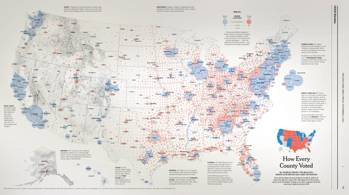
In the print edition of today’s NYTimes, a full-page map of the presidential results so far showing the margin of victory for each candidate, county by county.
74
2K
6K
3
40
251
I much prefer the MOC globe I built a few years ago than the official one. More
#Lego
No Technic pieces. Better
#cartography
.

11
22
248
Californian Snowflakes - monochrome
#map
of record snowfall (to date) using real snowflakes. Hi-res, how-to, and reusable Wilson Bentley snowflake styles on the way.
No rainbows were harmed making this map. Feel free to comment, and critique.
#Snowfall
#CaliforniaSnow

14
40
247
@justinelszasz
I agree, patterns are largely known but most maps don't do a good job of illustrating them.
9
3
231
I'm seriously thinking of proposing a new
#cartoMOOC
to powers that be. The next level. Carto 2.0. Go beyond defaults. Secret sauce. Taking it to 11. More
@John_M_Nelson
than you can throw a stick at. More
@epunt
. More
@wesleytjones
. More
@NathanCShephard
+ others. Interested?
39
6
229
My
#lego
globe is on display at
#esriuc
next to the Creative Cartographic display that
@John_M_Nelson
& I curated. Find it...

14
42
231

Jack just shared the news that
@ArcGISPro
was heavily used in the Thai cave rescue. Wowsers... makes me so proud and humbled to be involved in geo, mapping, and working with the guys who make the products that do this
#EsriUC

6
85
219
Some things that turn 50 in 2019
Boeing 747 Jumbo Jet
Concorde
Apollo 11
Led Zeppelin's debut album
The Beatles final concert
Sesame St
Monty Python
The Internet
Woodstock
Tic Tacs
UK death penalty abolished
QE2
Scooby Doo
Harrier Jump Jet
Where Eagles Dare
ATM
Esri
Me (today)
45
21
218
I built the world! Hard custom build but super fun. If you're coming to
#EsriUC
look out for my
#lego
#globe
on a special
#creativecartography
display
#cartography
#maps

6
41
211
Just in time for tomorrow's
#AnnularEclipse
in the USA here's my map showing time of maximum eclipse, by location, and what extent you might expect to see (assuming no cloud cover). Use solar viewing glasses!!!
#map
#cartography
#AnnularSolarEclipse
#Eclipse

12
59
208
Personal news: at a little after 10am BST my daughter started calling me grandad. HUGE congratulations to Ellie & Jack on the birth of their daughter ❤️

26
0
205
Can't tell you how heart-warming it is to see
@BBCNews
@sophieraworth
explaining what a
#cartogram
is and why it's better than a geographical
#map
for
#GE2019
Proper
#citizenscience
#cartography
to inform & educate viewers


3
31
200
Just acquired a fantastic set of old Soviet military Topo 1:500,000 maps of the UK and look, Shetland gets its very own big box!


8
19
187
🚨 ANNOUNCEMENT 🚨
My new book
#ThematicMapping
: 101 inspiring ways to visualise empirical data is published as an
@Esripress
eBook on 31st August. Print version hopefully to follow. Further details and links when I have them.
T-27 days, and counting.
#ThisIsMyTruthTellMeYours

8
31
197


A 1 dot per vote 2020 US Presidential election map (>158 million dots)
Hi-res print (36" wide):
Interactive web:
#Politics
#election
#ElectionResults2020
#usa
#america
#President
#Maps
#cartography
#dataviz
#ddj
Thumbnail below.

7
55
177
Ladies and gentlemen, boys and girls, cartographers and mapmakers, let me introduce
#cartographybook
. It's a real, live thing. Photos courtesy of
@CathyEsriPress
. And I bet some of you thought it'd never get finished. With a lot of help, it did.


13
35
177
My daughter Eleanor was born in 1998. That same year I got my PhD from
@uniofleicester
. Today I was proud as punch to see her graduate from my alma mater, share her special day, and celebrate her success. Congratulations Ellie
@fieldellie_
#LeicesterGrad

4
2
171
Total Eclipse: new map by me showing the time, obscuration, and appearance of the eclipse for over 1,500 locations across the US in readiness for April 8th.
Hi-res download:
Blog:
#totaleclipse
#eclipse
#eclipse2024
#sun
#moon

17
35
171
If you're here to see my maps then they're at .
#cartographybook
available from online booksellers . Feel free to stay for various rambling thoughts.

8
23
158
Without a doubt the 1991
#FACup
final. If that absolute idiot Milford had sent Gazza off for one of the two red card offences Forest may have won. OBE may have retired on top, and we may still be in the top division
#nffc

If you could change the result of one game in footballing history.
What would it be?
480
17
671
14
11
162
Rebuilt the Arctic Fox journey in
@ArcGISPro
ahead of
#EsriUC
demos next week to explore the issue of
#mapprojections
. For this map, Polar Stereographic is tough to beat.
5
39
160
Mappy side project at an advanced stage. Just the screw heads to paint and the watery vignette to fill in.
#Election2020
#Inauguration

9
16
157
What amazes me about this is Boeing calculated a flight path to account for eventual Web Mercator map
5
61
157
This Swiss map of inequality is terrific. A well constructed bivariate choropleth. But what I really like is the hillshade that masks out the unpopulated mountain areas. Because Switzerland! (ht
@gmapsmania
)

1
23
159
Teaching Cartographic Best Practices Is a Must. Roger Tomlinson: "We must educate GIS professionals on how to design, create, and use maps effectively—and not as a sidebar to other topics but as a primary focus on concepts, skills, and aesthetics"

3
47
158
Really enjoying 'Better Data visualisations' by
@jschwabish
. Graphs. Charts. Maps. The world needs these books.


2
20
157
Breaking: In a shock move, and after a week of heated debate, the International Cartographic Association select Web Mercator as its official projection 🤦
#ICC2023

11
12
158
Corona coxcombs - an interactive web map by me showing historic case totals for
#coronavirus
#Covid19
. It showcases a technique created by Florence Nightingale for data over space and time (Built with
@Esri
@ArcGISPro
; blog and how-to coming this week)

11
48
156
"
#ThematicMapping
: 101 inspiring ways to visualise empirical data" is published TODAY! As in, it's available right now as an eBook.
I hope you enjoy exploring the world of thematic mapping as much as I did making the book. Let me know!
#ThisIsMyTruthTellMeYours

4
34
156
My contribution to
@pinakographos
map projection trading cards is Gall-Peters, channeling Arthur Robinson's famous observation that the map looked like "wet, ragged, long winter underwear hung out to dry," with reference to previous cartoons by Peter Vujakovic and
@wesleytjones

9
16
151
I thought I'd be the only one who made the journey from Redlands but a very special guest joined us in London
@StanfordsTravel
for the
@EsriPress
#ThematicMapping
launch this evening. What a privilege to have Jack join us!

5
2
151
#30DayMapChallenge
Day 1: points
#sneakpeek
of forthcoming
#thematicmapping
book: 101 ways to map same data
There's going to be a free large (36in wide) poster showing 2016 presidential election as a dasymetric dot density map with 1 dot per vote. Nearly 130 million dots.

10
24
147
One is a visual data dump. The other is a map. It doesn't take much to turn one into the other but it makes a big difference beyond simply aesthetics.

Same variable, same territory, same week, two different color palettes & two different styles.
@okmesonet
&
@nytimes
.


14
55
341
9
22
143
No trip to Vienna is complete without a trip to the globe museum. Only ~420 beautiful globes to explore!
#eurocarto2022
7
8
142

#mapsathome
Published for 1964 New York World’s Fair, beautifully detailed axonometric map of part of Manhattan by Hermann Bollmann. Drawn by hand from 50,000 ground & 17,000 aerial photos to view all parts of map at same scale. An (almost) monochrome planimetric map verso.


8
20
140
Breathtakingly brilliant attention to detail. Anyone know who made it?

42
22
142
Some things never change when sharing a tin can in the sky with other humans. While everyone else stares at small screens watching Netflix with shades pulled down, I'm looking at the view outside. Nothing on a screen compares.


13
4
140
Woahhhhh....
@epunt
brought her stunning embroidered ski trail map into work today, and gave a lesson on the cartography of the different line types. Such a beautiful map and so expertly crafted.


2
10
134
Saturday morning map shocker: Mercator projection used in CORRECT context with rhumb lines (loxodromes), as straight segments conserving angles with meridians to represent direction of travel. Allows navigators to follow constant bearings. A watershed moment for map projections.

3
39
131
Great job by
@BBCNews
calling out some of the really poor Australia fire maps doing the rounds and explaining why they are misleading. This is called critique, without which large segments of the population would remain oblivious.

3
42
131

Raising a glass to a colleague who has very sadly, and indiscriminately lost his life to cancer. Awfully sad. Too young. Map on my friend

3
1
130
I made a map of attendees for this morning's
#EsriUC
UC Central Live show. 53% of attendees are US based which renders a choropleth or proportional symbol map unsuitable due to the large outlier. But dot density works! 1 dot = 1 person. That's nearly 70,000 randomly placed dots!


6
32
130


Recently acquired this beautiful pocket map of Sydney's suburban railway from 1939. The original
#becksploitation
?


8
31
131

My one dot one vote Presidential election map seems to be enjoying a bump so for new followers interested in the map, and others I made of the 2016 election, here's a write up with further links

4
34
127
#mapsathome
Brand new book by
@wesleytjones
on drawing fantasy maps. Useful for non-fantasy maps too. Beautiful book from highly talented cartographer & illustrator. Highly recommended. . Delighted for Wes that's it's out in the wild. Deserves to do well.


3
23
127
A huge thank you to the
#nacis2019
community for entertaining this bit of
#sharpiegate
#cartographypen
silliness. Here's the finished map. Already wondering if there's a
#nacis2020
presso in this.

8
23
123
#30DayMapChallenge
Day 3: polygons
#sneakpeek
of forthcoming
#thematicmapping
book: 101 ways to map same data
2016 presidential election result counties & county equivalent polys with millions more polys made to throw shade across the map & give the illusion of 3D

2
15
126
For the last decade I've written a blog just to note my most favourite maps of the year. Anyone still read blogs? Anyone interested?
15
0
127
#ICC2019TOKYO
Map awards. Winner of the Educational Products category is Cartography. (yay!)

16
11
125

Graphical Cartograms in ArcGIS Pro - an
@Esri
blog by me sharing a new tool to create Dorling and Demers cartograms from geographical maps.

4
27
123


Based on the work of
@infowetrust
(also ht
@mbostock
@tomshanleynz
) breathing new life into the magnificent colours and symbols developed by Émile Cheysson I'll soon be releasing an
@ArcGISPro
style of the same

2
17
119
#mapsathome
My mum made this needlepoint map of my home county of Nottinghamshire, UK as a gift for me in the mid 90s. She even added a small Nottingham Forest logo that locates my childhood home, close to the football ground I've been to over 800 times. Also, sign your work!

8
5
117

4
2
117

Finally tracked down a copy of this cartographic masterpiece. It's a challenge to make maps this good today, let alone in 1944. And all for $3.50. Bargain!
#mapsathome


7
3
116

#mapsathome
World Geo-Graphic Atlas by Herbert Bayer, privately printed for CCA clients in 1953. A masterpiece of cartographic design. Each double spread is different, built around the theme. Bauhaus inspired minimalist crisp style throughout. A lot of graphics. A lot of isotype.


3
8
114
With only pieces from
@LEGO_Group
#WorldMap
set here's my second custom map to add to the Spilhaus: British Isles. Still a few pieces left over for a mini map or two...
#LEGO


2
8
112
In no particular order, just *some* of the maps in the
@nacis
map gallery that I really liked 1/n


2
14
113
Custom map 1 from
@LEGO_Group
#worldmap
#cartedumonde
#mapamundi
set: Spilhaus Plastic Ocean. Bathymetry. Tectonic plate boundaries. Antarctica towards centre. Land (tan) surrounds and blends into background. 'South' arrow. FUN!

3
9
111
#30DayMapChallenge
Day 12: Population
"Planets, moons, and selected objects in space scaled by population" [still]

7
9
112
Sneak peek at an animated 3D version of John Snow's Cholera map which I'll be showing how to make at
#EsriUC
6
20
108
Quick attempt to finesse basic arrowhead origin-destination static distributive flow map into something more 'human'. Dots perhaps give sense of numbers being people. Tough when it's country level data to do anything more nuanced to show scale of the crisis.
#cartography
#Ukraine

12
15
111
Maps of the Turkey/Syria earthquake - a cartoblography review by me on the design of maps of the disaster.
Lots of good examples. A few not so good.

3
34
108

Proud to share that my
@EsriPress
book
#ThematicMapping
has just won the International Cartographic Association first prize for Educational Products. Wow, thanks!!!
Publishes in print March in US. Early April elsewhere. Pre-order now at all good online book stores.


7
10
107
