
Alex Boreham
@cyclonicwx
Followers
7,867
Following
638
Media
4,051
Statuses
13,972
Tropical meteorologist, B.S. @floridastate , incoming Masters student @FloridaTech . Amateur web, Python, & GrADS programmer. Also known as Not Sparta
Naples, FL
Joined July 2017
Don't wanna be here?
Send us removal request.
Explore trending content on Musk Viewer
İran
• 491178 Tweets
Kyle
• 249452 Tweets
サッカー
• 122212 Tweets
Enrique Márquez
• 103821 Tweets
Sunderland
• 100899 Tweets
オフサイド
• 97058 Tweets
スペイン
• 92599 Tweets
Francia
• 81347 Tweets
Emily
• 65050 Tweets
Julian
• 56023 Tweets
#ErdoğanınYanındayız
• 54591 Tweets
Ekrem İmamoğlu
• 52055 Tweets
Mascherano
• 50703 Tweets
Ron Paul
• 45158 Tweets
Arabia
• 41834 Tweets
Game Informer
• 26849 Tweets
#FRAARG
• 24893 Tweets
Angola
• 24435 Tweets
#SonÇağrı
• 22027 Tweets
Hepimiz Erdoğan'ız
• 20786 Tweets
Argentins
• 18565 Tweets
Joshua Cheptegei
• 17648 Tweets
準々決勝進出
• 16778 Tweets
Equi
• 14820 Tweets
Simeone
• 14676 Tweets
Zenón
• 14197 Tweets
Almada
• 11291 Tweets
Mateta
• 10329 Tweets


With the explosion of the ash cloud ending, there is another, less flashy but still very interesting thing going on. First off, with weak winds in the troposphere, but easterlies in the stratosphere, the top of the ash cloud is getting sheared off, revealing the tropospheric part
7
218
798
A new pass through the NE eyewall of
#Beryl
finds flight level winds of 155kt, solidly supporting a 140kt intensity, making Beryl a Category 5 hurricane. This beats the record set by Hurricane Emily (July 17, 2005) by 15 days (!!). Having such a strong storm in a region usually

20
212
687
This volcano eruption is producing some sights we won't see on satellite for a while after. The explosive updraft powers right into the stratosphere, and the warming with height there makes the blob appear warm/shallow. There's also the shockwave and condensation pushing NE
15
183
656
Looks like
#Bret
's structure has changed - recon in storm finding some weird stuff as it flies in the powerful convective bursts
24
55
453
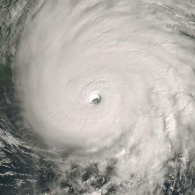
Incredible satellite presentation with
#Beryl
with a stadium effect, clear eye. Category 4 intensity makes sense but I could see it intensify a little more past 115kt. Just incredible stuff out in the MDR for June 30. History being made today
8
90
372
This 24 hour loop of
#Lee
intensifying today just shows how quick this whole process was. From a sloppy looking minimal hurricane to a near Category 5 now. Has just been going at it since those VHTs went off last night. Historic event particularly for this part of the basin
7
82
316
The sun sets on Hurricane
#Beryl
. Given the approaching shear this is about as strong as it will get. Won't see something like this again for probably a few decades
17
38
305
Another sunrise on
#Beryl
which somehow did not degrade during the night. Stunning stadium effect eye
2
47
300
Recon finds
#Beryl
on the precipice of Category 5 strength with flight level winds of 151kt and pressure dropping all the way to 937mb, close to July's all-time low of 929mb. We'll see if this data is enough to get it there

3
66
285
Appears shear has decreased enough that
#Beryl
has been able to wrap some convection around rather than always failing to get all the way across. Sign that it may be able to start strengthening again soon as it approaches NE Yucatan Peninsula. Recon later will be interesting
2
49
281
After a messy EWRC a few days ago, we're seeing the opposite case playing out now. There is literally no difference since before the EWRC aside from the eye slightly cooling and the CDO slightly warming. Very strange
6
33
266
#Beryl
is now looking much less healthy, with a lopsided structure and a cooler, smaller eye. Looks like the high shear has finally gotten to it and it has begun to weaken amid less favorable conditions
19
33
265
New recon in
#Beryl
shows pressure continuing to fall, with extrapolated values of ~928mb. If a dropsonde can confirm this, it is the new low pressure record for July, replacing another record from Emily (2005)

10
61
254
Despite becoming a category 5,
#Beryl
isn't done - a new dropsonde from its center reveals pressure has begun to drop again, down to ~936mb now. Starting to wonder how low it can go at this point

13
39
249
Unsurprisingly
#Beryl
is north of forecast and will likely emerge over water soon. This is when dry air may disrupt the system, but if it doesn't it will likely strengthen more than forecast as well. If it moves offshore we'll have recon to see what its structure is like now
12
38
236
Changes with
#Beryl
recently on satellite are very impressive. Eye clearing this fast with cooling eyewall convection means another peak is probably on the way. Note the positive eye temperature! Very healthy structure
6
76
233
Leave it to
#Beryl
to come in way ahead of expectations. Extrapolated pressure is down to 962mb, a full 12mb (!) lower than earlier this afternoon. Could see it possibly rapidly intensify before running into land tomorrow morning

7
53
232
Despite high shear
#Beryl
is hanging in well. Recon found it still maintaining winds ~135kt with pressure in the upper 940s. Impressive vortical hot tower activity ongoing too for the amount of shear hitting the storm
5
46
224
As always,
#Beryl
continues to overperform. It has a clearing eye on IR imagery with deep CBs wrapping around the southern eyewall. Recon goes into the storm in 5-6 hours, would not be surprised if this was already a major hurricane by then
7
41
215
Looking at WV imagery, you can see shear has fallen, letting
#Mocha
intensify further. Double outflow channels have helped it become quite strong, near Category 5. Unfortunately, it's nearing a vulnerable area. Hopefully damage isn't as bad as expected given a storm this strong
6
53
199
As you may know the MDR has generally been much warmer than normal. This warm anomaly has gotten so excessive at this point that it compares to climatology in *late July*! We'll see if the warmth holds on through spring but hard to see it all disappearing by then

10
46
203
Nice burst of outflow on
#Beryl
's west side as it starts interacting with the awakening TUTT and the divergent upper flow to its SE. The addition of another outflow channel may allow for Beryl to intensify even more rapidly than it is currently
2
41
203
#Beryl
is once again trying to wrap convection around its center. The current burst is making its way around the SW side of the eye and seems to have helped the eyewall close off again on Grand Cayman radar. Shear will try and stop this attempt, we'll see if it manages to
7
32
196
Some nice personal news: I'm headed to
@FloridaTech
's meteorology program this fall! I'm very excited to begin graduate school and further my education. Looking forward to the next couple of years there!

40
4
194
With TD 7 now
#Fiona
, I've added this new, special colortable entitled "Shrek" just for this storm. Now it really needs to become strong so we can see what a major hurricane looks like with this
See it while it's here:

17
22
192
Looks like the Atlantic is slowly evolving to that "all warm" pattern we've gotten used to over the years instead of the current canonical +AMO. Strong warmth expanding to the NW causing the mid-lat cool pool to shrink
8
41
186
Impressive pressure drop on latest pass into
#Beryl
. Down 5mb since the last one only 2 hours ago. Getting in the top tier of Atlantic TCs even for July now. Winds continue to support 130kt intensity

1
32
189
Nice upper divergence north of
#Beryl
this morning, thanks to flow between a ULL and upper ridge. Seems this sort of upper divergence and favorable interaction with the retrograding ULL will help Beryl through its trek in the Gulf, with an added possible jet interaction later
5
34
188
#Beryl
certainly looks like a major hurricane by now with deep convection surrounding the eye (some new convection on the south means a full wrap now) while the eye is still visible on IR imagery. It's certainly had yet another good night
3
39
185
The sun sets over
#Lee
and its new stadium effect eye. Quite the day of intensification (not over yet, either). Always love the sunset shots of these strong storms
1
35
181
A sign that
#Bret
may be stronger than estimated right now - it has begun to slow down. The ML ridge is weaker than at llvls, so this suggests it feels more mid-level flow. What does this mean? Seems more likely it moves more N and feels less ML shear with weaker westward motion


10
21
184
Pretty textbook 🍤 from
#Beryl
now with an obvious band having appeared. Between that and what MW data has shown, an inner core appears to be forming already. Might get an episode of RI in the immediate future
5
31
183
#Beryl
did finally manage to wrap convection around its eyewall and try to close it off. It's overcome the shear, and I imagine another round of RI will commence tonight
3
30
182
Neat structural changes with
#Beryl
tonight, going from the CCCesque blob to a healthier look with banding returning. Getting some cyclonically rotating convective bursts on the east side suggesting a possible coupling to the LLC. As long as shear doesn't strengthen, we should
4
32
185
An upper level recon plane is traveling to the Cabo Verde islands, and is about to arrive. They are expected to conduct a research mission in the area tomorrow. Certainly nothing I can recall seeing before

13
19
180
This is such a weird storm. Despite massive shear, the latest VDM from
#Beryl
reports a closed eyewall and the center dropsonde implies a minimum pressure of 969mb, which is down from the last one! Seems the persistent bursting which has made IR look a little better is helping


6
34
180
Seeing the behavior of volcanic ash clouds (this from
#Ruang
) on satellite is always really neat. The warmer center of it is actually higher up, in the stratosphere, and the updraft weakening can be seen by the cooling off plume's center as it sinks back towards the tropopause
4
41
179
The nice thing about 2024's tropical waves so far is how easy they have been to spot. There's a new one south of Cabo Verde and it is clearly visible thanks to widespread convection. Very high SSTs for May are allowing for more convectively active waves like this
14
31
169
With the Pacific jet extension having trended stronger, we'll probably end up closing out the month in a very warm, super El Nino-like pattern instead of a change to a cooler one. Not much cold air to speak of until the jet retracts, probably sometime in January
#godzillanino


12
30
169
New NMME continues to trend towards stronger La Niña/warmer Atlantic. As a result precip anomalies manage to become increasingly impressive, with the dark blue now reaching from Africa to the Caribbean uninterrupted! Hard to think of another year with this sort of signal
7
34
167
As the sun comes down it's easy to see where
#Beryl
's eyewall is, with convection rotating around its southern side. If we see this wrap around the north it will be a sign Beryl is winning against the persistent easterly shear and just about to begin more rapid intensification
3
26
165
The Caribbean has had an impressive bout of warming recently, almost catching up to the warmth of the open Atlantic east of the Lesser Antilles. On top of this, a baroclinic low forming this week will likely make the trade winds sluggish which could continue the warming trend


11
31
167
#95L
is looking good going into DMIN with a good amount of banding and the classic "S" shape of a developing wave. Band to north is also a good way to fend off some of that stable air. If DMAX brings it more convection it could try to develop as soon as tomorrow
2
22
165
@DylanFedericoWX
Worth noting as have seen similar strong signals in 2021, 2022, 2023..... not need to overhype and bring up 2005
2
2
163
#Mawar
is already quite impressive today, but there's a sign conditions will improve further. A trough to its north is digging a little, providing another outflow channel. This process has already begun w/ outflow expanding north. All that's in its way now are internal processes
3
26
153
Nice placement of
#Mawar
in this frame, the tropical WPAC with an impressive super typhoon smack in the middle
2
33
152
Fairly substantial VHT activity getting going with
#Idalia
now, enough so that you can start to see the eye on visible imagery. After some time of organization may be a sign that the strengthening phase is beginning. Unfortunately recon is leaving so no new obs right now
2
25
152
Recon in
#94L
found a vortex well defined enough for a VDM, suggesting it's just about well defined enough to be a TS. The large amount of TS winds around also tells us this system would probably become Chris


1
27
154
Dropsonde confirms basically dead on 962mb.
#Beryl
is indeed on the upswing and probably quickly

Leave it to
#Beryl
to come in way ahead of expectations. Extrapolated pressure is down to 962mb, a full 12mb (!) lower than earlier this afternoon. Could see it possibly rapidly intensify before running into land tomorrow morning
7
53
232
7
25
158
The diurnal maximum treated
#95L
well. Its northern vortmax continues to be convectively active, and now this area has a closed circulation given cloud motions though it still seems broad. There's also some nice inflow in spots and the beginnings of banding. Well on the way to
2
18
156
Dry air still lurks around
#Beryl
, shown by outflow boundaries to its south and east. However it has managed to become healthier, with more organized convection and some nicer banding. It's attempting to close off a core but so far hasn't yet. Faster intensification is likely if
9
23
153
Thanks to
#Beryl
's record-breaking trek through the Atlantic in the past ~10 days, the 2024 season has generated more accumulated cyclone energy than the entire 2013 season (35.9)! A storm like this this early is about as strong an argument you can get to back up the hyperactive


1
26
153
The recon mission ended up finding
#Ian
a mess, with a not very discernable mid-level structure. What they did find is that the low level center is around 14N, significantly further south than expected. May lead to some more W trends in the near future

10
30
148
#Beryl
is rapidly intensifying as recon flies inside it this morning. Probably up to 125-130kt by now. Pressure falling each pass with it down to 950mb or so now. Once again extremely impressive storm for July 1, wonder how strong it gets before unfavorable conditions affect it


5
36
151
#Mawar
with that buzzsaw look now. Eye is about as clear as it gets, and convection around it is zipping around the center. No doubt a very powerful typhoon. Bad trend for those in Guam as it has rapidly intensified ahead of schedule
1
35
145
#95L
continues to improve. It still has a healthy banded structure as before, and some mid-level rotation. Along with this the low level flow and that easterly inflow has become stronger. Suggestive of an intensifying low. Westerlies to the south show us a closed circulation, but
2
17
147
One thing that tells me
#93L
has become a TD is how far its circulation has begun to reach, suggesting a well-defined vortex in the convection. For example: inflow emerging near Grand Cayman; westerlies extending to the bottom of the Yucatan; and northerlies on west Yucatan coast
7
20
146
Although conditions have improved since yesterday,
#Mawar
has weakened from its impressive peak yesterday, thanks to the one thing in its way, internal processes. Indeed, an EWRC occurred and it is now having some trouble reintensifying
2
29
140
Per recon
#Beryl
is getting starting to strengthen more quickly. Pressure has dropped to 985mb, we've started to get stronger winds nearing hurricane force, and temperatures have risen each pass, indicating a strengthening warm core cyclone. Still needs to close off the core but


2
33
146
#Jova
has gone absolutely wild today. To cap it off, it has now become symmetrical with a very warm eye and is probably a category 5 hurricane by now. One of those great eye candy storms you can sit back and just appreciate with no one threatened by it
4
22
140
Nice gravity waves from this powerful updraft in
#Franklin
. Always cool to see the rapid outward propagation too as the air has nowhere to go but outwards from the updraft
3
18
140
With another strong -NAO ongoing and associated weak trade winds, the MDR and eastern Atlantic are warming up again. Hard to imagine values even higher but here we are
10
24
142
As
#Beryl
finishes its EWRC, it appears to be starting to intensify again with a large burst of convection wrapping around the eye (covering it up after remaining warm during the EWRC) and eyewall reflectivity spiking as a result. Bad news for Grenada as Beryl makes its approach
3
39
144
#Lee
continues its insane RI run with its eye pushing 20C. With this sort of symmetry and such a warm eye, this is probably solidlee in the Category 4 range. Question has become if recon goes in in a few hours and finds a Cat 5 from this
3
21
140
#Beryl
refuses to let go of Category 4 winds, with the NE eyewall still supporting 115-120kt intensity despite rising pressure and satellite presentation. If the hurricane models are right we should see fairly quick weakening starting, we'll see if they turn out to be correct


6
26
144

We got a pass through
#Beryl
's NE eyewall. Maximum flight wind of 108kt is just enough to support a major hurricane strength after its quick dip to Category 2 strength. Seems winds are responding to that pressure fall

3
22
139
SPV set to strengthen even more within the coming days. Some of the highest 60°N, 10mb zonal wind values I've seen. Very circular and consolidated vortex. Also appears this will start coupling more with the troposphere, allowing warmer weather to begin

15
25
139
Even on the 30 second mesoscale sector,
#Idalia
's eye is noticeably warming, going from -45C to -35C in just 10 minutes! Yet another sign of the strong intensification ongoing
4
22
133
-NAO/AO is appearing on the horizon along with a more favorable period for cold in eastern North America. Impressive to see anomalies like this so far out on an ensemble mean! Easy to see the fingerprints of El Nino too with the strong subtropical jet signal


2
24
137
Somehow,
#Beryl
persisted. Though it has weakened from before, we still have yet to see the wholesale collapse of the structure that hurricane models predicted yesterday. Can't say I'm that surprised it found a way to remain stronger than expected


5
21
139
We have recon in
#Alberto
which has found it has continued on the organization trend. Pressure has fallen to 992mb now, and high winds (suggesting an intensity ~40kt) exist close to the center to its SE, suggesting the circulation is becoming less broad. Looks like this slow


9
23
136
Appears to me that
#92L
's wave axis is rotating more N/S this afternoon. With it tilting more upright and increased convection, 92L might be starting the process of TCG soon. Seems at this rate it's probably 1-2 days away from forming
1
16
136
There's something satisfying about watching strong inflow into a TC on visible imagery.
#Beryl
's eastern inflow is certainly no slouch
4
12
136
A little bit of more personal news: I'm happy to announce I am transferring to
@floridastate
's meteorology program this fall. I am excited for the next two years and the opportunities this will bring!

34
3
132
The quiet in the East Pacific is getting impressive now. Its current seasonal ACE has fallen below 1% of average and it is less than 10% of the next lowest value for July 13! There's only one 10% AOI there right now so the record inactivity will continue for a little while longer

4
23
137
At this point, it appears the extended EWRC
#Mawar
went through allowed for dry air intrusions which it currently is struggling with. Almost looks like a storm that has upwelled cold water, but in the pocket of high OHC it's in, this is unlikely
2
22
126
#Beryl
remains a Category 4 hurricane per recon, with flight level winds supporting 120-125kt. However, its southern eyewall has become weak because of the shear, giving it a very asymmetric wind profile. Its pressure continues to rise slowly (now up to 952mb), but it seems the


0
26
131
Fresh center dropsonde shows
#Lee
's pressure is down to 928mb, so the rapid deepening has not stopped. Also, look at that subsidence!! What you'd expect for a storm knocking on category 5 strength

2
26
129
The buoy we're looking at is just NE of the cold spot in
#Idalia
's convective burst. This suggests that the center is well embedded in the convection, & the way radar is looking suggests it's not a CCC pattern but that an inner core may be trying to form if things go well for it


5
17
128
As a result of recent warming in the MDR the 26C isotherm has crept up to Cabo Verde. This is very early for this sort of thing, which climatologically only tends to happen in late July! Yet another case of SST in the MDR running far ahead where it should be


6
31
129
#96L
has become convectively active entering the Caribbean, dropping heavy rain on the Lesser Antilles. As usual for July, conditions are unfavorable in the east/central Caribbean, but as it slows down further west it may be worth watching for the potential of development there
1
18
129
#Mawar
's eye has cleared out impressively today. Luckily this has happened during the local day, so we're able to get a lot of photogenic visible imagery. Likely already a super typhoon with several days of favorable conditions ahead
3
22
125
It's drier out ahead of
#Beryl
as shown by the outflow boundary and areas with totally clear conditions (not even cumulus). If this is able to reach the inner core it would be quite disruptive and would end Beryl's uncanny ability to maintain in the face of shear
7
10
130
Looks like double vortical hot towers going around
#Ian
's center. More indications of an inner core being built under there
4
21
128

It turns out we watched
#Beryl
weaken as shear disrupted it after its quick ramp up before recon. Luckily this means a weaker storm for those impacted in the Yucatan and Cozumel. During the mission, we found it bending north again, north of forecast. May spend less time over land

3
30
126
#Beryl
is looking rough this morning, with no real central convection and any convection outside of that area. Going to take a while to sort out the structural issues which is lowering the ceiling for eventual intensity. Good trend for TX coast but Beryl will still pose a threat
7
19
125
In the space of an hour and 15 minutes,
#Idalia
's minimum pressure as measured by recon has dropped from ~968mb to ~965mb. This 3mb drop in such a short time is pretty solid evidence that it has started the anticipated rapid intensification before landfall


6
23
121
As with many sheared systems,
#Bret
is trying to fight back. Nice convective activity near (but to the east of) the center which will allow it to maintain strength or maybe even intensify a bit
3
27
120
The Niño 3 index now that the cold pool is beginning to surface
5
20
126
#Ian
has entered an environment much more favorable than it was in just last night. Outflow is now expanding in all quadrants, suggesting that shear has rapidly declined. Ian will take some time to organize & stack first, but once an inner core forms there is a big risk of RI
5
22
124
After days of disruption, the shear over
#Lee
has come down. Looking south of Lee, thunderstorm anvils no longer are getting pushed aggressively N into its core. Now, it's trying to improve the long-open S eyewall structure after an EWRC. Wrap attempts are now somewhat successful
4
25
123
Recon has found a weakly closed center with
#92L
, but still falling short of TC status. Nevertheless, it would not take much more organization to become a TC. The current convective blowup could allow this to happen with a center reformation towards it supported by its strong


4
30
122
Love watching storms like these on the satellite. Stunning image as the sun begins to set on
#Mawar

1
19
121