

Andrew Berrington
@ahberrington
Followers
2,953
Following
1,081
Media
1,529
Statuses
7,501
Meteorologist and research associate @ OU CAPS | M.S. OU '20 | B.S. UBC '18. Severe wx/music nut and contributor for @USTornadoes @torarchive . Opinions my own.
Norman, OK
Joined March 2015
Don't wanna be here?
Send us removal request.
Explore trending content on Musk Viewer
Edmundo
• 263422 Tweets
CHARLOTTE X TIKTOKLIVE99
• 228971 Tweets
#Narin
• 226687 Tweets
ANILPIN WE ARE THE ONE
• 194506 Tweets
#ปิ่นภักดิ์EP6
• 186729 Tweets
#光る君へ
• 108845 Tweets
KIM TAEHYUNG
• 54227 Tweets
プロジェクトKV
• 53756 Tweets
Zapatero
• 50873 Tweets
東京ドーム
• 39376 Tweets
İdam
• 30738 Tweets
Kostic
• 29906 Tweets
ポルノグラフィティ
• 27650 Tweets
SEVENTEEN AT LOLLAPALOOZA
• 21604 Tweets
NFL Sunday
• 15407 Tweets
ماهر الجازي
• 15325 Tweets
源氏物語
• 15153 Tweets
#降り積もれ孤独な死よ
• 14706 Tweets
LESSONS FROM BIU
• 13654 Tweets


Never seen this picture of the Mount St. Helens eruption in 1980 before, apparently from somewhere near Portland.
Source reddit thread:

35
301
2K
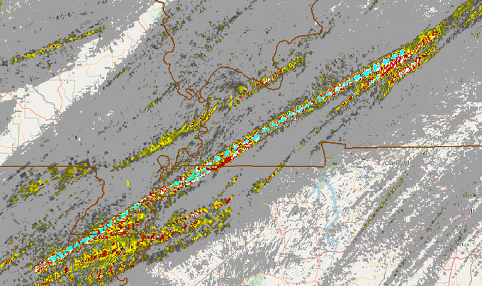
This is, by far, the most intense/persistent MRMS rotation track I've ever seen.
29
545
2K
Lord, that was no ordinary damaging wind event that came through Houston
#txwx
. Looks like the aftermath of a major ice storm re: the electrical grid.

48
499
2K
Absolutely violent tornado with multiple vortices on Reed's livestream NE of Corning
#iawx
.

8
135
862

Steam eruption at Yellowstone. I'm sure there will be a very nuanced and calm reaction to this on this here website.

23
50
617
Screengrab from this video of the violent tornado near Caruthersville
#mowx
earlier tonight.

7
120
403
An unrelated search yielded this color photograph of the 6/15/1990 Stratton/Trenton NE violent wedge tornado + massive vault on Reddit posted by a resident of the area whose farm was hit. Yeah... holy smokes.

13
48
390

In the Cayce
#kywx
area, there appears to be some rather deep gouges in the ground along the path of the core of the tornado. Could be impact marks or even some semblance of a "trench" like what was observed in Philadelphia and Smithville MS following 4/27/2011.


8
98
356
Pretty clear that we are in the midst of a historic December tornado outbreak here.
3
42
351
Ok, so normally I don't respond to this guy because it's not worth the energy, but this, this warrants a response. Depression is absolutely, positively not "a choice against living life normally", stop with that ignorance right here and now.

23
21
283
Happy to announce that I successfully defended my Masters thesis today and will proceed to pursue a PhD at OU concerning sub-seasonal severe weather forecasting. Thank you to all who helped me in reaching this point!


39
2
279
Exhibit A on why there needs to be a radar in Paris TX or Hugo OK.

11
32
271
Using this event as an example really isn't a good idea. Telling people to get in their vehicles and evacuate ahead of a huge tornado moving 50 mph in the dead of night (in potentially poorly lit rural areas) is asking to make the disaster worse.

42
16
255
This photo of the Baca Co.
#cowx
tornado (the storm nobody was chasing near Campo) from 6/23 via
@NWSPueblo
’s event page, holy crap. Knew that storm had to be going nuts, but that is a whopper.

9
36
252
Pretty crazy stat to put both the extreme tornado activity of this December and low activity in peak severe season in recent years into perspective.
Number of EF2+ tornadoes in May 2017, 2018, 2020, and 2021 combined: 30
Number of EF2+ tornadoes in December 2021 so far: 50
2
64
227

So, with the gracious help of
@CameronJNixon
's hodograph map plotting code, I have adopted it for use with ERA5 reanalysis. The result? Hodograph maps for tornado events going back to 1950. Shown are 3/21/1952 23z, 5/26/1955 03z, 4/12/1965 00z, and (holy crap) 4/3/1974 21z.


34
36
193
It is pretty (read: very) rare to see output like this from the 3 km NAM for a severe weather event given some of its biases. If it wasn't already apparent, Friday has some serious potential and possibly over a large area.

9
29
192
You're going to be hard pressed to find an ensemble mean that looks more favorable than this for a week in May in terms of severe potential (12z GEFS mean).
9
32
179

Maybe I'm just jaded, but I don't feel like driving right into a tornadic circulation (as opposed to, say, deploying probes and leaving the path) to record the pressure drop is a "huge day for science".

INCREDIBLE TORNADO INTERCEPT by
@BradArnoldWX
using a mobile
@cyclonePORT
unit! A sharp pressure drop was captured near Taylor Landing, TX as the tornado and RFD were caught on video and live sensor data. Huge day for science!
#TXwx
60
412
2K
11
18
175
@Seahawks
Because of some of the worst playcalling you'll ever see. Is it too much to ask for a competent offensive coordinator?
9
10
159
Well, that might answer some of the questions about storm coverage...

2
13
178
Popping a 90 on the SREF sig tor ingredients 72 hours out probably isn’t a great sign for the Southeast on Thursday (again).

8
35
164

Looked at radar data of 5/24/11 yesterday and noticed this. A left mover (arrow) forms in N TX & shoots N ~ the I-35 corridor, destructively interfering with several tornadic/budding tornadic storms (incl. EF4 Goldsby), continuing all the way N of OKC. Animation via
@NWSNorman
.
10
31
163
@Ladder23Rum
A storm that has lasted an exceptionally long time at a very high intensity, producing at least two very intense tornadoes.
4
8
164
I ask in an unfortunately serious tone: does NOAA and, more broadly, the wx/climate research community have a plan for how to deal with Project 2025 should it come into fruition even in a muted fashion? Job security seems questionable given that nonsense.
8
13
160
I think tonight reaffirms that, if the conditions are conducive, significant/destructive tornadoes can and will occur across the US irrespective of time of day, time of year, or upper trough tilt.
1
17
153
Just as an FYI, the content I've posted over recent days (hodograph maps and tornado paths) is aimed at a final purpose. The goal is to create a website to replace the recently deactivated Tornado History Project as a sort of "one stop shop" for historical tornado info. 1/3


6
17
152
This is really not the type of signal you want to see in the dead of night with a 70-80 kt LLJ in play.

6
21
152
I am euphoric to announce I have accepted an offer to pursue a Masters degree in meteorology at the
@ousom
starting this upcoming August.
Thank you everyone, who made this opportunity possible for me, from the bottom of my heart (that weird kid below's dreams are coming true)!


21
2
148
Thread: As an avid tornado history guy, I've always marveled at
@sigtor2019
's work in documenting tornadoes. I've wondered how they would look plotted on a map. So that's what I did, for all 643 F4+ tornadoes in the 1880-1949 period. Plotted by decade starting w/ 1880-1889. 1/20

4
36
142
Chris FL tornado is truly the worst of the worst in this community and I really hope no one continues to amplify his platform. Good lord.
18
12
142


After further consultation with experts by NWS Charleston, it appears the Scotia/Estill
#scwx
tornado from the Easter outbreak has been upgraded to an EF4. This is now the third violent tornado of the outbreak and the fifth of the year (oh and it occurred at 3 in the morning).


7
43
130
The damage that the Matador
#txwx
tornado inflicted on typically robust mesquite trees is pretty crazy. Seems analogous to a few other high end TX tornadoes such as Loyal Valley in 1999. Photos via Tim Marshall’s fb page.


4
21
127
Oh man, where to even begin with this one. I suppose constantly tweeting unrealistic model graphics showing 2-4' snowstorms in the winter or every TC becoming a cat 4 or 5 is somehow better?

7
3
117
What on Earth are some of these model progs for Saturday? 5000-6000 CAPE, mid 70s dewpoints, and 70 kts of effective shear with rather minimal capping? Good grief...
5
4
116
Some truly unreal aerial footage from a drone of the deadly Beauregard, AL EF4 yesterday as it was near maximum intensity. Credit:
@LiveStormsMedia
cc:
@USTornadoes

9
62
114
Thread on a few thoughts re: last night. These mid/upper level westerly flow events in Dixie Alley mean serious business. This is the 250, 500, 700, and 850 mb plots from 00z. Very strong upper level winds favoring long-tracked storms (0-8 km shear in excess of 100 kts). 1/8


4
28
112
You're a PhD in meteorology with 71k+ followers, many of whom looking to you for information (and taking what you say seriously). All this does is detract from the facts about what is going on with the climate.


22
12
113

Never call a Dixie event over until the front has passed.
0
5
111
Credit
@FreddyMcKinneyR
right now, I know we all kind of mock the "saving lives" thing sometimes re: chasers, but you actually may have done so. To handle that situation with calmness and reassurance to that family was remarkable.
5
6
113
Few quick edits from the El Dorado/Oluskee
#okwx
long-lived tornado today. Never been this close to a violent tornado before, just absolutely crazy. Cameo by
@CameronJNixon
and
@wxmann
's vehicle in the third image.


2
7
106
Nothing like being in my Severe Weather/Forecasting class when a 45% tornado risk is issued in the D1 outlook.
3
3
104

Alright, with
#ERA5
reanalysis being extended back to 1950 today, figured I'd take an opportunity to plot 300 hPa, 500 hPa, 850 hPa, and MSLP/10 m wind for a number of tornado outbreaks in the 1950-1978 timeframe.
First up: 4/3/1974 (Super Outbreak) @ 22 UTC. 1/11


5
19
102
One of the things that strikes me the most about this video is how large the damaging wind field is outside of the main condensation funnel. Taking roofs off buildings and toppling the wind turbines well outside the funnel.

Check out this whip-like vortex in the
#tornado
south of Greenfield, Iowa with
@theScantman
on the controls. Full 4K video is on YT WATCH:
421
4K
18K
4
4
100
Remains to be seen whether the environment will be tapped by storms, but this 21z Aberdeen sounding has to be one of the craziest observed soundings I've ever seen based on raw parameter space.

6
16
98
Tomorrow's severe threat aside, my attention has been directed to this crazy dashcam video of the Lincoln NE tornado from 4/26 as it hit the warehouse that yielded a high end EF3 rating.

2
30
100
Needs to be Dr. Fauci and the healthcare workers, full stop.


7
5
98


@JackSillin
@NWSSPC
Sorry but no SPC did a horrible job. No moderate risk until the day of. No high risk. They should have had a moderate risk out the day before followed by a high risk the day of. I had a my highest risk out two days prior. O am sorry but this was no accomplishment.
145
5
14
2
1
98
Why are you driving like this?

Tornado just crossed the road right infront of me in Elgin
@NWSSanAntonio
@ReedTimmerAccu
33
194
815
18
4
96
While tomorrow is obviously a potential significant severe event, the 00z GFS decided to double down with an even stronger shortwave coming through Texas on Thursday. 150 kt max at 500 mb? That is utterly insane at that latitude.

7
8
95
Quick DSLR edit of the Cole
#okwx
tornado and supercell from earlier from east of Washington.

0
21
93
I think I tweeted earlier this year that it was the first time I had seen the SPC SREF sig tor ingredients pop a 90 in the cold season. Well this is certainly the first time I have seen the same parameter pop a 90 this far out in advance of a setup, and it does it for two frames.


5
19
93
That's a rather... ahem... interesting EPS mean for April 27th.

2
10
90

Probably not a great sign when the ≥50% probabilities from the SREF for STP ≥ 5 cover this large a region over 60 hours out.
A relatively high confidence forecast from this ensemble for a large region favorable for significant tornadoes Thursday.

0
27
88
ARE YOU KIDDING ME

180
916
3K
2
4
90
I highly, highly do not recommend trying to chase on Friday.

3
5
86
Via McKenzie Atwood on Facebook, this appears to be a picture of the EF5 Hackleburg/Phil Campbell/Tanner AL tornado from 4/27/11 near Mount Hope
#alwx
. Monstrous inflow band on the right side.
Link:

2
9
88

Uhh, this 3 km WRF simulation of the 1974 Super Outbreak is certainly worth checking out if you have any interest in historical severe/this event.


2
17
87
Per NWS damage assessment toolkit, looks like there is now an preliminary EF4 rating for the Linwood, KS tornado from yesterday. Would be the first EF4+ tornado of the May sequence.
#kswx

4
47
86
That tornado evolution on the tower cam in Jonesboro was way too similar to the 4/27/11 Tuscaloosa tornado on ABC 33/40.
4
11
81
It costs zero dollars to not be an asshole, and some people apparently can't afford that.
2
5
83
Both of my grandfathers passed away quite a long time ago so...

9
1
81
First tornado from cyclic tornadic supercell (still producing) N of Woodward, OK.

5
28
79
With a third EF4 tornado confirmed by
@NWSMemphis
via PNS and looking over
@torarchive
's database going back to 1880, this event is now tied for the most violent tornadoes in a single event in December with 12/18/1957 in S IL.
4
5
82
This picture right here should be making the rounds on all National news networks.

2
21
80
What a chase today, at least 5 tornadoes near Vernon and Lockett TX. More later.


2
2
80
I don't know who needs to hear this, but a "death ridge" that shows some sort of progression in less than a week after first developing probably isn't a death ridge.
6
0
78
When your ensemble means at 500 and 850 mb look like this 5 1/2 days out, it's probably time to start paying attention.


1
10
80

00z Little Rock RAOB is, to put it lightly, a problem...

3
9
80
Well that's just a bit of a signal from the 12z HREF.

4
8
79
The many faces and transformations of the Eldorado
#okwx
tornado on May 23rd of this year, in chronological order spanning about 20 minutes of time.

6
9
80
Here's
@CameronJNixon
doing his thing (don't even think I need to add a descriptor haha).
#AMS2021

4
5
78
Intense supercell with a history of a long lived significant tornado in E TX is moving into this shear environment from the Fort Polk radar VAD. Lord almighty.

5
26
73
I was already concerned about tomorrow before today, but what happened today heightens it even further. One of the more bullish forecasts you'll see here.


3
8
79
Assigning threshold values for risk to parameters especially in the thermodynamic space can result in problems, see this SRH/CAPE diagram from Davies and Johns 1993. There are many violent tornadoes, major hail events, and tornado outbreaks associated with "lower risk" CAPE here.

5
7
77


This might be my favorite tornado photograph that I’ve ever taken (granted, there are multiple other candidates from 5/23 in SW OK).

5
3
73
Should probably add that, not only did the low-level temperatures and dewpoints overperform in many spots, the upper level trough ended up more amplified than forecast. This was a powerhouse trough with mid-spring thermodynamics in places.

1
12
73
One difference between previous sequences this year with this potential upcoming active period (post-Thursday) in recent model guidance is *days* of strong southerly flow in the low levels out of the Gulf/W Caribbean to allow for plenty of deep moisture transport.
3
16
73
It's pretty hard to fathom just how far above every other recorded December tornado in the US that main KY tornado was Friday evening. Nothing else even comes close. Have there been violent tornadoes in December? Sure, but nothing like this.
4
8
73
You mean like when Dorian was going to make landfall in Alabama.

7
2
72
Last night into this morning is easily one of the most destructive and prolific QLCS tornado events I’ve ever seen across GA, E TN, and the Carolinas, likely with several intense tornadoes embedded. 4/26-27/2011 overnight comes to mind.
0
14
70
Given the number of supercells out there rn moving into a strengthening LLJ axis, we may be about to witness a very nasty event here.
3
8
70