
UNOSAT
@UNOSAT
Followers
13K
Following
7K
Media
3K
Statuses
7K
Official account of the United Nations Satellite Centre - UNOSAT, UNITAR, imagery analysis, #satellite solutions, #GIS
Geneva, Switzerland
Joined May 2010
🛰️📷Before and after of #Hungatonga . First preliminary damage assessment for the volcanic eruption and induced tsunami for #HungaTongaHungaHaapai available.➡️ #TongaVolcano #tongatsunami @OCHA @UNOCHA_Pacific @UN_Pasifika @TongaMissionUN @disastercharter
11
488
762
The Emergency Mapping service is activated for both #earthquakes (#deprem) that struck #Turkey today. Check the dedicated webmap for the latest updates.🗺️➡️ You can also send ground pictures via UN ASIGN 📲.

9
101
343
In #Pakistan, Khairpur Nathan Shah and Mohenjo Daro Ancient City remain surrounded by floodwaters, making humanitarian access to these areas very challenging.➡️ @isdb_group @NSAPAKISTAN @PakUN_Geneva @PakistanUN_NY @UNinPak @UNESCAP @DisastersChart
7
162
236
This map shows the damages of #Tongaeruption in Nomuka village as of 17 January:.🔹104 structures were analyzed in the cloud-free area, almost all the structures were covered with ash, 41 were identified as damaged.➡️#HungaTongaHungaHaapai #TongaVolcano

4
110
178

New analysis: approximately 65% of the total road network has been damaged across the Gaza Strip as of 29 May 2024. UNOSAT identified approximately 1,100km of destroyed roads, 350km of severely affected roads, and 1,470km of moderately affected roads. ➡️

23
103
165
Our Emergency Mapping service is activated for the Volcanic #eruption over #Tonga .The @DisastersChart is triggered, first assessments to be published soon . #TongaVolcano #tongatsunami #HungaTongaHungaHaapai

4
52
128


On Atata island, 72 structures were identified as damaged & 28 as potentially damaged. The entire island appears to be covered in ash. ➡️ All the latest updates are available on the live map.🗺️.#TongaVolcano #TongaTsunami

4
68
98
Based on an image from 10 Oct we identified 228 destroyed structure, 148 severely damaged & 365 moderately damaged structures, 1 school compound (Omar Bin Abd Alaz) visibly destroyed:.▶️ 🔔More analysis on #Gaza to follow.@ochaopt @UNDPPalestinian @UNICEF

1
32
90
🇹🇩 Satellite-detected flood impacts in N'Djamena City, Chad (26 Aug 2024): 50 km² of land affected, with around 7,900 buildings impacted. 📸 #Chad #FloodMonitoring #Geospatial #Satellites #Flooding

1
21
90
We released an initial satellite imagery-based damage assessment over the northern part of Gaza strip made in support to various UN agencies:.➡️ More analyses over other areas to follow

5
33
81
We're close to eradicating polio. Only 5 cases worldwide this year. Let's keep up vaccination coverage @WHO #GISforSDGs

1
60
67

Our new agricultural damage assessment shows that 45% of Gaza's farmland shows significant damage due to the ongoing conflict, based on analysis of times series Sentinel-2 satellite imagery. Learn more: . #Gaza #FoodSecurity

3
38
70

UNOSAT releases extensive report on damages to #WorldHeritage Property in #Syria
http://t.co/TzxOkGEIBU
@UNESCO @UNDP
http://t.co/sut2BN76Pv.

5
123
48
Preliminary satellite-derived damage assessment in central, western and northern divisions, #Fiji shows evidence of severe damage, notably in Bua province. Full assessment here: #CycloneYasa @FijiNDMO @UNOCHA

0
23
54
Comprehensive satellite imagery-based assessment covering all the Gaza Strip showing impact craters on roads, in fields, and damages to buildings is now available: .➡️

0
31
49

We’re collaborating with @UNGlobalPulse to develop Pulse Satellite, a tool that can identify & count refugee shelters to support humanitarian efforts. Inputs from UNOSAT analysts are driving the #MachineLearning process. #AIforGood #dataprotection @UN_innovation @HIPNorway
1
33
47
Activation of the emergency mapping service for #floods in #Pakistan. The first map showing the detected water extend is available: .🔹~2,700 km² of lands appear to be flooded.🔹~750,000 people are potentially exposed .➡️ @PakistanUN_NY

2
22
46
All the analysis results and latest updates on the #Tongaeruption will be available on the live web map .🗺️➡️ @UNOCHA_Pacific @OCHAAsiaPac @TongaMissionUN @DisastersChart .#TongaVolcano #TongaTsunami #Tongaeruption #HungaTonga #HungaTongaHungaHaapai.
1
23
45
We are very pleased to announce that UNOSAT is now officially the. ✨🛰️United Nations Satellite Centre🛰️✨. A big thank you to @antonioguterres for the recommendation & to @GuatemalaONU & all ECOSOC members for their support. 👉

1
19
47
An estimated 37,000 homes were destroyed in Maungdaw, Buthidaung and Rathedaung, #Myanmar between August 2017 and March 2018. Nearly 400 villages/towns affected out of a total of almost 1,000 #Rohingyacrisis

2
48
44
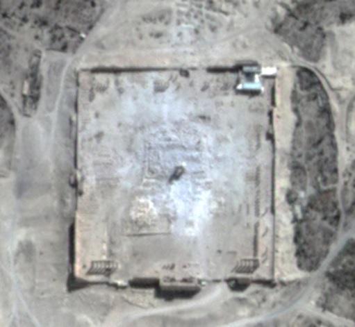
UNOSAT satellite analysis confirms Temple of #Bel #Palmyra #Syria main building destroyed @UNESCO @UrtheCast @UNITAR
http://t.co/IZWRN0Tsil.
17
149
39
We have been activated by @UNOCHA after the eruption of Mount Nyiragongo, #DRCongo and triggered @DisastersChart . Live web map👉.#NyiragongoEruption

2
20
43
📢We are hiring!. 🔹TRAINING & CAPACITY DEVELOPMENT, KNOWLEDGE MANAGEMENT.🗓️14 January 2023.👉 🔹TRAINING & CAPACITY DEVELOPMENT.🗓️14 January 2023.👉 🔹GIS / REMOTE SENSING EXPERT.🗓️1 February 2023.👉

1
19
44
Day 2 of our training in #Kathmandu, #Nepal is well underway. Heavy focus on working with satellite imagery and gathering free and open geospatial data for our participants @NDRRMA_Nepal @UN_Nepal

0
11
43

#PalaisdesNations is on lockdown. See the difference in car parks from 14 January and 19 March. @UNGeneva and all international organisations work from home and keep delivering.

0
10
38

New preliminary satellite-derived damage assessment report over Acapulco town & along the shoreline of Acapulco Bay, #Mexico . ➡️ 🔹Widespread damaged structures & affected road observed . @UNOCHA_Americas @DisastersChart @save_children
2
30
41
It is a great pleasure to meet with the Rwanda Space Agency @RwandaSpace Very good discussion on capacity development for satellite imagery analysis 🌍🛰️.@UNITAR

0
14
40
Before & after 🛰️📷 of Mango Island, #Tonga: .🔹extensive damage to the shoreline.🔹ash deposits covering the entire island.➡️ #HungaTongaHungaHaapai @UNOCHA_Pacific.@UN_Pasifika @TongaMissionUN @disastercharter @NZUN @NZUNGVA @KARI @Roscosmos @USGS
1
33
39
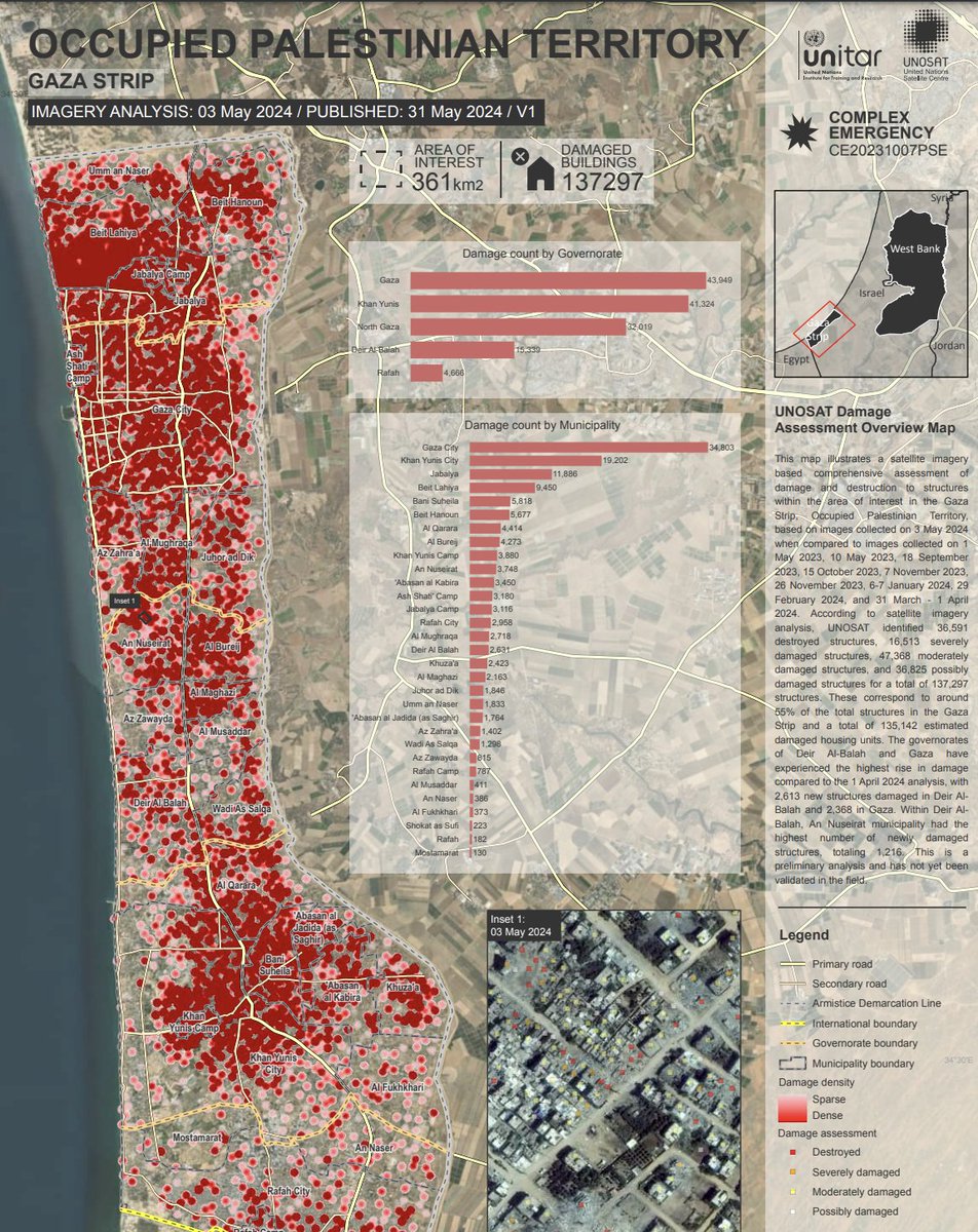
🏚️ According to our analysis, we identified 36,591 destroyed structures, 16,513 severely damaged, 47,368 moderately damaged, and 36,825 possibly damaged structures. A total of 137,297 structures, or about 55% of the total in Gaza, are affected. #DamageAssessment #SatelliteImagery

10
35
40


Our Emergency Mapping service is activated over #TheGambia for the oil spill along the Gambia river .We triggered the @DisastersChart on behalf of @OCHAROWCA & @OfEnvironment1:.🔹~5 km² of floating oil is potentially detected within the analyzed area.➡️

1
19
35

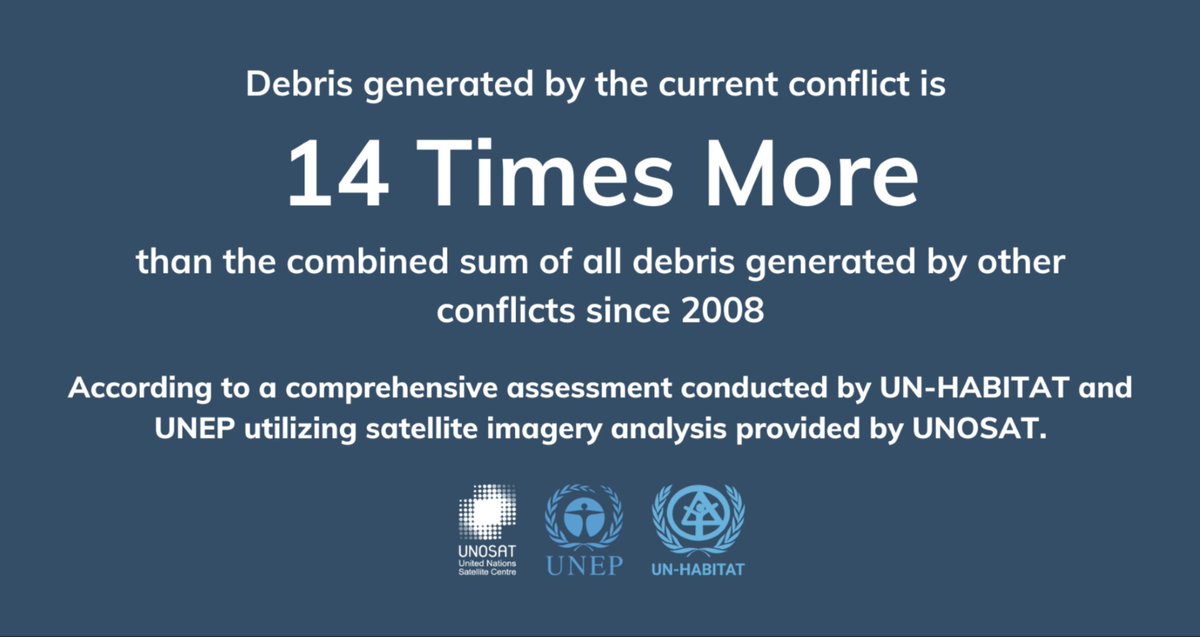
Gaza: debris generated by the current conflict is 14 times more than the combined sum of all debris generated by other conflicts since 2008. Our press release:
3
24
36
Our Rapid Mapping service is activated following the eruption of #mountsemeru in Indonesia. The preliminary assessment shows widespread damage to houses, roads & agricultural lands. ➡️@indonesiaunny @UNinIndonesia @OCHAIndonesia @DisastersChart
1
11
34
What an honour! Thank you @GEOSEC2025 for selecting @UNOSAT to receive the GEO SDG 2022 Award. The Emergency Mapping service has been operational for almost 20 years, what a great way to kick off our anniversary celebrations


1
8
33
New preliminary satellite-derived damage assessment for #TCOtis-23 over Guerrero State, #Mexico, 01 November 2023:. 🔹No major damage observed. ➡️ @UNOCHA_Americas #CENAPRED
2
25
35
Today we discussed how to take our collaboration with @FijiNDMO further! Exploring GIS-based applications to develop to support their operations and foster the power of #EarthObservation for Disaster Risk Reduction


0
10
35


We published our map of rapidly assessed damage occurring between 3 December 2017 and 23 February 2018 in #EasternGhouta, Damascus Governorate, #Syria. 62.5 km² analysed, multiple areas with new major damage

2
50
35

It was a pleasure to welcome the Minister of Foreign Affairs of Norway, Ms @AHuitfeldt, and her delegation today. Presenting the range of work done at @UNOSAT using satellite imagery analysis for peace, security and resilience.


0
12
33
The Emergency Mapping service is activated over #Syria for the #earthquake west of Gaziantep - M7.8.➡️@IFRC @UNEnvoySyria @UNHCRinSYRIA @UNinSyria
1
18
34
We are pleased to discuss innovative application of geospatial information and OpenSource technologies for Disaster Risk Reduction & #ClimateResilience with the @gsi_intl, Prof. Taichi Furuhashi at @mapconcierge and Prof. Yoshiaki Fukami at @KeioGlobal. @EOCommonSensing #DRR

2
19
34
The United Nations Satellite Centre (UNOSAT) has released an updated assessment of the damage inflicted on buildings in the Gaza Strip. 35% of Gaza Strip Structures were damaged since the outburst of the conflict. Read our latest press release:

9
17
31
We triggered the @DisastersChart for the #earthquake in #Syria. Find all the analysis results on the dedicated web map.🗺️➡️ You can also send ground pictures via UN ASIGN 📲.

3
9
32

Our training on applications of geospatial information technology for disaster risk management and decision support has kicked off today in #Kathmandu, in partnership with @UN_Nepal & @NDRRMA_Nepal

0
9
32
The @UNOSAT webmap for the #earthquake that struck #Turkyie and #Syria shown at #EsriFedGIS23 Plenary as an example of impactful use of #ArcGIS technology for emergency response and situation awareness. 🗺️@UNITAR @Esri

0
13
32
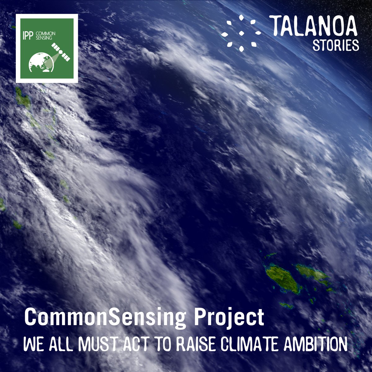
#CommonSensing is leveraging earth observation data to provide vital info regarding disaster and #climate risks to help Fiji, Solomon Islands & Vanuatu build resilience & combat the effects of #ClimateChange #Talanoa4Ambition @spacegovuk @commonwealthsec @EOcommonsensing
0
15
29
Our dataset was used to develop UNOSAT FloodAI, but is also often used by others to advance the use of machine learning for GIT applications. See this example of researchers working towards automatically detecting buildings damaged by conflicts.👉
0
12
30
UNOSAT is celebrating 20 years in 2021. ✨New decade, new style✨.It starts today with our maps, take a look 👇. (1/2)

1
4
31
You are here with @UNOSAT live Webmap on a monitoring screen at @FijiNDMO‘s National Emergency Operations Centre (NEOC) that coordinates #Fiji's response to #CycloneHarold. #RapidMapping @UNOCHA @DisastersChart @FijiGeneva @UN_Pasifika @UNOCHA_Pacific @EOCommonSensing

1
11
31

It was a pleasure to receive Amandeep Singh Gill @UNTechEnvoy in our Geneva office this morning and discuss how we leverage geospatial technology in support of the @UN system.

0
7
30

Our emergency mapping service is activated over #Bangladesh for floods. This map shows surface waters in the northeast divisions:.🔹~6,800km² of land are flooded, .🔹4,900,000 people are exposed.An interactive dashboard is also available.➡️

1
11
27
Over 6,000 damaged structures in #DeirEzZor, #Syria. >1,000 of these were destroyed, >2,000 severely damaged, and nearly 3,000 moderately damaged Damage density map:


1
16
11

This map shows the effects of the #HungaTongaHungaHaapai volcanic eruption in Mango island & damage assessment as of 18 January 2022, where 26 structures are identified as damaged.➡️ #TongaVolcano #TongaTsunami #Tongaeruption

1
17
29
Day 3 of the #Nepal training is in full swing in #Kathmandu. Today participants are using satellite imagery to analyze flood impact and assess exposure @UN_Nepal @NDRRMA_Nepal

1
8
27

Join us at the Disaster Resilience Week .📆Thursday 26 August.🕧12.30 UTC+7.👉 ✨We have a lot to celebrate!✨. #ESCAP75 #DRWeek2021

0
10
27


Save the date ‼️. Women in Geospatial: a Development Perspective in Oceania.📅7 June.🕗8 a.m. CEST - 6 p.m. FJT. with @geospatialwomen

0
10
26
Our Advanced Training on Earth Observation (EO) and Geospatial Information Technology (GIT) Applications for Climate Resilience has also started in Suva, #Fiji ⬇️.Welcome to all the participants!.#ClimateChange #GIS #Training.@EOCommonSensing @spacegovuk

2
10
26
This map illustrates the ongoing flash floods in Afghanistan in Baghlan province. @unafghanistan . 📷:

1
8
26
0
9
24
The course on Satellite Imagery Analysis for Crisis Assessments started this week with @SURGE_UNDP #SurgeDataHub. Over 110 participants connected from across the world are learning to leverage the power of #GIS & integrate @UNOSAT Emergency Mapping analysis in crisis assessments

1
12
24

Our Rapid Mapping service is activated over #Haiti, and we triggered the @DisastersChart on behalf of the @UN's Operations & Crisis Centre, with @Pwoteksyonsivil & CENAPRED.➡️ #haitiearthquake

1
11
26
Happy New Year from UNOSAT ✨. In 2021 we will be celebrating 20 years of operational support with satellite analysis & applied research
1
5
26
Thrilled to announce our renewed partnership with @noradno to further strengthen capacities in the use of Geospatial Information for Improved Resilience in the Asia-Pacific and Africa regions. Focus will be on #DRR, #ClimateResilience, environmental preservation & #FoodSecurity

1
10
26
We've developed a fully automated approach to rapid flood mapping & cut map production time by 80% to benefit .relief and recovery in collaboration with @UNglobalpulse & @durham_uni. For a detailed account, consult the scientific paper @MDPIOpenAccess:

1
12
26
We're wrapping up a @REACH_info project documenting rehabilitation in Tal Afar & mapping water quality in #Basra & elsewhere in #Iraq. For example, the overall condition of water in Basra's canals is poor, with high levels of pollution observed
1
9
26


The Earth observation for Sustainable Development course started today! 💻🛰️. This 2-day webinar series aims to develop capacity in agricultural remote sensing in #Iraq . #EO4SD @WBG_Agriculture @esa


0
7
24
We are pleased to launch the self-paced version of our e-learning course on “Introduction to Geospatial Information Technology Applications, Flood Forecasting and Early Warning Systems in West Africa” today, in collaboration with @wascalclimate @HKV, @CSIR_WRI & @FUTAkure.

1
6
25
