

TravisCountySevereWx
@TravisCOSW
Followers
14,629
Following
213
Media
17,720
Statuses
38,558
@NWSSanAntonio Partner • SKYWARN® Spotters • Daily/severe wx info for Austin & Travis County • NOAA Weather-Ready Nation Ambassador™ #ewxspotter #VOST #atxwx
Travis County, Texas (Austin)
Joined February 2015
Don't wanna be here?
Send us removal request.
Explore trending content on Musk Viewer
連休最終日
• 130565 Tweets
गोपाल मिश्रा
• 105565 Tweets
Libya
• 83360 Tweets
#SVT_SpillTheFeels
• 71884 Tweets
Album of the Year
• 70655 Tweets
LOVE MONEY FAME OUT NOW
• 66496 Tweets
SVT SPILL THE FEELS DDAY
• 61409 Tweets
Super Eagles
• 49983 Tweets
神奈川県警
• 49210 Tweets
アトラス彗星
• 48928 Tweets
#2024MAMAVOTE
• 45294 Tweets
Artist of the Year
• 39568 Tweets
CONGRATULATIONS JUNGKOOK
• 33586 Tweets
#njkopw
• 31853 Tweets
BOOKEXPO X OHMLENG
• 27930 Tweets
ファイターズ
• 24182 Tweets
レモンポップ
• 22717 Tweets
地震速報
• 19803 Tweets
#スポ男
• 19276 Tweets
千葉県北西部
• 18574 Tweets
Daron Acemoğlu
• 14986 Tweets
棚橋引退
• 11822 Tweets
ペプチドナイル
• 11366 Tweets
最大震度3
• 11042 Tweets
ホークス
• 10735 Tweets
ソフトバンク
• 10388 Tweets


Pinned Tweet

Monday: sunny with near record highs again (current marks: 95° airport, 96° at Mabry). Low humidity.
Extended: one more day of crazy heat tomorrow and then we can enjoy a legitimate cooldown to finish the week. There’s even a slight chance of showers by late week!


0
0
3
Not trying to make light of a potentially serious weather situation ... but here is the difference between a "watch" and a "warning."
So right now the ingredients for a tornado are in place.
#YouAskedForIt

14
121
576
I’m sorry … we try refrain from political commentary here but this … is … just … 😂😂😂

ERCOT leaders expect summer weather to be cooler than last year, which will put less of a demand on the power grid
87
14
75
24
69
530

Just thought we would share this. Water headed towards Lake Travis

Heavy rains overnight created localized flash flooding and saw the Llano River at Llano, Texas cresting a short while ago at 32,000cfs and 12.7 ft. Storms have now passed here in Llano but a Flood Warning remains in effect.
#TurnAroundDontDrown
#txwx
#ewxspotter
@TxStormChasers
6
39
152
6
74
460
Woah! 😧

1
60
383
Coming Attractions: next week, the High Pressure Ridge of Death will be centered exactly over ... us, according to the European model which is usually right more than the others. What does that mean? High temps 105-107 degrees quite possible.

29
84
290
Winter Weather update: just got off the NWS webinar and here are the main takeaways as of this afternoon:
1) Arctic front timing sped up; expect front arriving in TravCo late Saturday evening; temps fall below freezing before Sunday sunrise (1/4)
5
56
240
Yes, it's Taco Tuesday but it also appears to be Tornado Watch Tuesday. Know the difference between a "watch" and a "warning."

3
48
246
Cannot emphasize enough that you do NOT want to be out on the road when these storms roll through. If you live west of
@EvilMopacATX
you'll want to be home by 5. If you live east of our favorite highway, be home by 5:15/5:30. Or just stay put.
11
52
238
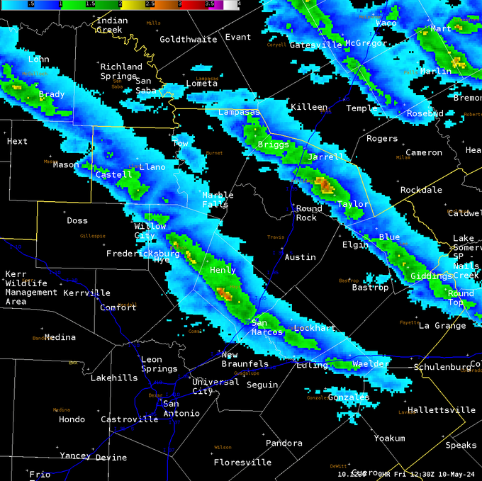
Whether it was the mythical Austin Rain Dome or pure luck of the draw, Travis County last night escaped a devastating hail storm.

Here is an algorithm's estimation of the hail swaths yesterday. It was obviously low in some areas, but gives a good depiction on where the hail storm's tracked yesterday evening.
5
33
157
10
30
209
If you can find a spot with a clear view to the north you might be able to catch a glimpse of the Aurora Borealis


5
21
204
Here is the estimated rainfall totals thru Saturday evening:

16
23
193
This! 👇


4
5
172
Area roofing and glass companies this morning like …
4
13
166
Tropical storm hits South Texas and what does Austin get? Increased wildfire risk! smh
1
27
159
Video from earlier this morning in San Antonio. Note how quick it spins up and then dissipates. this is what we are dealing with this morning.

8:15am 10/25/23: Just received this video from I-35 near 281. Possible, very brief tornado in San Antonio.
@NWSSanAntonio
49
530
2K
4
24
155
Some good news on the horizon ... a real cold front. Looks to be about one week away. These model projections show you how much below normal temps may be next Wed morn and then actual temps. Mid 50s? Yeah! Sadly tho no rain.


1
10
154
Well … at least we got a 20-degree temperature drop out of it. As for rain … 😂
8
10
146
Technically this isn’t accurate … but it’s still probably true

A HEAT ADVISORY will be in effect for Austin from this afternoon through September 30th
55
352
2K
4
13
147
Upcoming Arctic airmass thread: You're probably going to see a lot of posts on X this week showing various computer model runs and the poster saying ("Just one model run but OMG!!!"), as it relates to the coming Arctic airmass. Those posts generally cause folks to freak out (1/x)
4
18
145
Show off! 😆 No, seriously, great job here

2
14
141

Weather people get teased about speaking in hyperbole. But it’s no exaggeration to say that we’ve barely begun in terms of freezing precip. This morning’s chaos on elevated roadways and bridges is the result of freezing drizzle alone. We expect actual rain showers to fall …
2
15
133


FYI, we’ll have an update for everyone later this afternoon after the NWS provides their afternoon forecast package. Probably around 3 pm. So stay tuned and thanks for following us.
4
3
130
Austinites waiting for that first fall cold front …
5
13
127
As it relates to
#Beryl
and her impacts on Texas and, more locally, our weather … please pay heed to trusted sources of information. Like
@NWSSanAntonio
or
@NHC_Atlantic
. There’s lots of doomsayers and … quite frankly … nut jobs on social media spewing unsupported (1/2)
5
14
128

Everything’s bigger in Texas … including our heat waves 🫠

Next Wednesday, large parts of Texas will be hotter than 99% of the planet during the peak of the heatwave.
Widespread temperatures of 110˚F or higher are forecast.
Only the Sahara Desert & Persian Gulf area will be as hot or hotter (🟡) than the Lone Star State 🥵

220
2K
4K
3
31
124
With a bunch of West Texas dust and cedar pollen in the air this morning, here’s our recommended clothing for the day …
3
16
118
Alright so will it storm here and when? Models show two possible times: around 8-9 pm this evening or around 3-4 am. We're consulting our senior forecaster now ...
10
2
114

Folks are probably wondering how tomorrow is going to play out. So are we?! 😀 But if the weather behaves as most of the computer models suggest, showers locally will develop in the early morning hours. They’ll be small and fast moving and radar coverage will increase … (1/x)
4
20
111
Early morning update on
#Beryl
. What is interesting is that Travis County is now in the forecast track “cone.”


2
15
112
Friday morning update on weekend Arctic front … timing of front has sped up a bit. Looks to arrive between Saturday midnight and daybreak Sunday. Projected temperatures also trending a bit colder. Looking more likely that once we go below freezing Sunday morning … (1/3)
1
25
110
Sunday winter weather update: here is our summary after being advised by our local NWS office ... as you have seen the Winter Weather Advisory active time was moved up and is now active. The main timeframe of any freezing drizzle/rain/sleet still expected to be ... (1/4)
3
14
106


How long will this current heat wave last? We have good news, of sorts. Longer-range computer models show the High Pressure Ridge of Death losing a battle to a developing trough of lower pressure over the Southern Plains/Texas by around July 4th.
2
3
100
Worth a retweet
The chances of an all-time record heat index AND a Rain Dome fail in the same day in Austin were 10,000,000 to 1
Well congrats, y'all just won the goddamn lottery!

33
93
1K
3
3
96
TravCo commuters: if you haven't left for home yet, it's probably a better idea to stay put for a few hours. Storms entering the county are showing explosive growth and road conditions will be terrible soon with heavy rain, strong winds, and hail. Please be safe out there!
1
35
95
We’ve had some questions lately - and we’ve wondered ourselves - if the number of severe weather events locally and in Texas is higher than usual. One thing we can say now is that Texas leads the nation this spring in “heavy weather” per an article in … (1/2)
8
9
94
Latest model runs are not looking optimistic for being able to observe eclipse on Monday. 96% chance of cloud cover over Austin at 1 PM on Monday

6
21
92
Red circle is Austin. Big storms firing down in Mexico that will move our way overnight. Things could get interesting from here down towards south Texas after midnight.

2
7
92
Please direct all "it didn't rain and you said it would" complaints to this account below.
2
4
88
He’s not wrong
Let me translate this ERCOT message for all y'all...
Texas is on the verge of rolling blackouts

70
643
2K
0
16
87
65 degrees for high temp on Friday, Oct. 4?! 😮Repeat after me ... I will not believe long range computer models which promise fall in 10 days time ... I will not believe ...

16
16
83
We hit 110° at Camp Mabry and 108° at the airport. The Mabry high ties for third highest max temp ever recorded. Let’s hope this is the worst of it.
3
16
87
URGENT!!! New Tornado Warning for almost all of Austin. This storm has a history of tornadoes and is on a path towards south Austin and downtown. Persons in these areas need to shelter NOW!

1
57
81
Why do we say "Turn around, don't drown"?

🙏🏾BREATHTAKING VIDEO shows moment big rig is swept away by flood waters on fwy in Livingston, TX. Witnesses yelling for driver to get out! The video shows man onto hood, waiting to be rescued.
#abc13
#flooding
#livingston
#houston
68
324
911
4
21
84
We dare you to find another NWS forecast discussion that had “chupacabra” in it. Our
@NWSSanAntonio
office is better than yours. 👍

4
31
83
If you observe any precip tonight, let us know what you’re seeing and include time/general location. Please use the
#ewxspotter
hashtag. “Ground truth” reports will assist the NWS. Thanks!
17
13
83
Saturday weather update per latest NWS info: the Arctic front is expected to be barreling through TravCo tonight in the 9-10 pm timeframe. Temps will quickly fall and when we all wake up Sunday morning, temps will be in the low 20s and won't rise above freezing all day (1/5)
1
11
80
Tonight … very cold with lows around 13°. If we do drop that low at either Camp Mabry or the airport, that will be the coldest temperature we’ve had since the Feb 21 Winter Apocalypse. Hard Freeze Warning and Wind Chill Advisory in effect until 10 am Wednesday.
Despite warming above freezing in some spots today, it will be the coldest night of this cold snap so far, with lows ranging from 8 to 20 degrees. Wind chills may fall to between 0 and 15 degrees but winds should be much lighter tonight. Avoid prolonged exposure.


4
35
130
2
21
81

Don’t walk on the highway. It is too dangerous. Drivers could lose control and hit you.
#ATXtraffic
#txdotwx

165
640
2K
4
28
78


Post of the night 😆

We have a Weiner dog storm on our hands!
#atxwx
#txwx
@ChikageWeather
@averytomascowx
@AustinBurkeswx
@atxwxgirl
@TravisCOSW

7
15
94
2
3
78
This should go without saying but ... PLEASE STAY HOME! We're monitoring police/fire radio and listening to multiple reports of accidents and cars sliding off the road. And it's 7 am on a Sunday morning ... so c'mon folks ... PLEASE.
2
21
75
If you have a Texas coast vacation planned for this next week … bring board games and the PS5 and some good books. It gonna rain!

🌧️⛈️ The latest 7-day precipitation forecast depicts two areas at risk of excessive rainfall, the Upper Midwest and western/central Gulf Coast. Be sure to remain weather aware in these regions, don't underestimate the power of water, and always
#TurnAroundDontDrown
!

2
76
187
3
17
77
Alright. That was waaay cool! Now it’s time to take off our eclipse glasses and put on our severe weather glasses.
1
7
76
5
7
75
1
4
73
The current mood about the cold front who never arrived ...
6
7
67
See the little line moving south? That's it. Cold front starting to push into the county
2
9
69
Keep those pipes from freezing once the Arctic air arrives on Sunday ...

1
36
68
We wanted to give a big shout out to the hard-working
@NWSSanAntonio
staff. Working 12+ hr shifts under high stress. Thank you!!
0
7
68
Two of our three team members are without power right now so we're sorry if we can't tweet as often as we'd like. Hope y'all are staying safe and warm out there.
4
1
69
The Gulf and tropical mischief next week may be our only hope to break this hot and dry cycle.

8pm EDT Tues 15 Aug: We continue to monitor two low probability genesis areas (both 30% 7-day 🟡) in the far tropical Atlantic, but note a new low probability area has also added in the Gulf of Mexico for early next week (20% 7-day🟡).
Latest Outlook:

65
570
2K
7
7
68
Monday eve/night: showers and storms ending this evening and then just partly cloudy ... thank goodness ... with no expected additional severe weather. Lows in the lower 50s.
4
4
68
Arctic front timing: subject to change of course … but as of now, it appears the Arctic cold front will blast thru our area Thursday morning somewhere in the 8-10 am range. Temperatures at that time should be in the low 40s. They’ll start dropping after frontal passage (1/3)
4
17
68
Local law enforcement and first responders are overwhelmed right now with accidents. Road conditions are already terrible. Freezing drizzle will continue and icing will get worse. PLEASE STAY HOME! No, you're not the guy or gal who can drive in this stuff. No one can.
1
17
67
The shelves by tonight at your local HEB or Randall’s when folks see the possibility of ice in this week’s forecast.
3
12
66
Hard freezes occurring Sunday night, Monday night, and Tuesday night with lows roughly 15°-20°. Evolving forecast so its important for everyone to stay up on the latest information. (4/4)
0
2
68
Looking ahead: latest projections from the two main long-range computer models show highs in the mid 80s next Thursday. The European model says rain with our cold front; the American model says "no rain for you!" Either way, confidence growing in our first real fall cold front.
3
7
67
We'll just kinda put these out there ... and quietly leave the room.


6
19
66
We will shoot straight with you on this account. We're looking at the potential for another 42-48 consecutive hours of temps at or below freezing. Current forecasts indicate about lunchtime Friday the temps rise above freezing to about 40 degrees.
#atxwx
3
23
66
Some lucky folks are getting rain! I see beautiful rain showers straddling the Hays / Travis County line at sunset this evening
#timelapse
#atxwx
#txwx
8
7
63

9:15 pm update - watching … waiting … hoping (for rain not severe weather)
3
3
61
Tornado warning has now been issued for Hays County just to our south. This includes San Marcos. If you know anyone in that area or along I-35 please warn them to shelter now! Very dangerous storm continues

1
23
63


Extended: the most welcomed cold front in years arrives tomorrow with rain (perhaps 1-2”) and cooler temps. Clouds and light rain behind the front into Friday. By the weekend we’ll see sunshine and it’ll be drier … with HIGHS IN THE FREAKIN’ 70s!!! 🥳🥳🥳

2
15
62
Yeah, we’re going to need to keep an eye on
#Beryl
Here is the latest satellite image of strengthening Tropical Storm
#Beryl
. Beryl is expected to rapidly strengthen and likely bring destructive hurricane-force winds and a life-threatening storm surge to portions of the Windward Islands. Follow the latest at


85
788
2K
5
2
62
Hey there western TravCo … look at you with all that rain! Congrats. 🎉
5
1
62
today into tonight and we may even have thunderstorms tonight with freezing rain falling and sleet. All of this will occur and fall on surfaces below freezing. This is a multi day event so buckle up, friends! And please stay home if at all possible. Our first responders
2
1
60
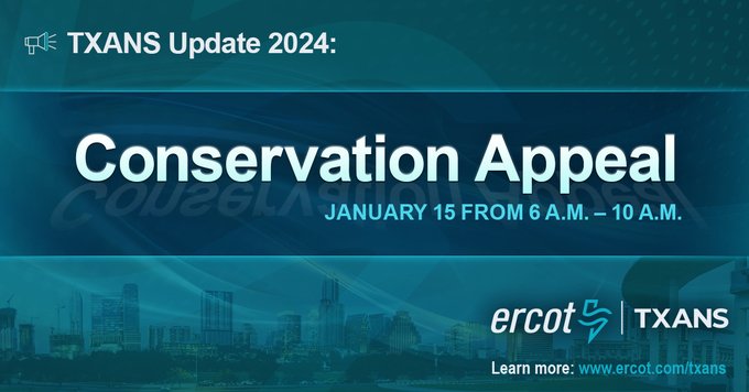
😳

TXANS Update—Jan. 14, 2024: ERCOT has issued a Conservation Appeal for Monday, Jan. 15, from 6 – 10 a.m. CT. Operating reserves are expected to be low tomorrow morning due to continued freezing temperatures, record-breaking demand, and unseasonably low wind. We request Texas
871
633
813
9
9
58