
London & Southeast 🔆
@TheSnowDreamer
Followers
29,188
Following
1,304
Media
23,412
Statuses
82,205
Daniel - amateur UK forecaster; all year round, somewhat sane, latest reliable wx tweets. My own thoughts. BSc Geography, MSc. Join me on Patreon 👇
London, England
Joined December 2015
Don't wanna be here?
Send us removal request.
Explore trending content on Musk Viewer
Bills
• 161504 Tweets
無料クーポン
• 138588 Tweets
Jets
• 120510 Tweets
carat
• 91390 Tweets
連休明け
• 86185 Tweets
リンク1
• 57494 Tweets
緊急入院
• 42333 Tweets
Rogan
• 41656 Tweets
अब्दुल कलाम
• 38699 Tweets
Aaron Rodgers
• 36817 Tweets
Hail Mary
• 28290 Tweets
पूर्व राष्ट्रपति
• 27057 Tweets
Josh Allen
• 26251 Tweets
भारत रत्न
• 22065 Tweets
#APJAbdulKalam
• 18666 Tweets
DG X ORM KORNNAPHAT
• 17472 Tweets
महान वैज्ञानिक
• 14462 Tweets
うさぎくじ
• 12290 Tweets
#たっぷりじゃなくてたーーっぷりクワトロ
• 12039 Tweets
エスクプス
• 10257 Tweets
ジョシュア
• 10214 Tweets


Pinned Tweet

Battling against severe light pollution in inner London but
#aurora
was definitely there very briefly faintly visible with naked eyes. Approx 00:35 BST.
A cold and clear night in London, Docklands, 4C the perfect night . Only the second known occurrence locally after evening of


16
10
167
@labourlewis
You shouldn’t stand for parliament then His Majesty’s Government, why did you take oath? Coward.
92
37
3K
This evening sees last sunset after 8pm in London until mid April 2025.
126
455
3K
These temperature forecast for Tuesday are simply unfathomable, example 41C in Manchester and Leeds, the existing record for former is 33.7C set in summer of 1976. There are no words to express how extreme this is, perhaps most extreme weather event in UK climate history.


56
651
1K
Best snow in years. Am I allowed to say I deserve it? 🤭
A very decent covering here in sea level
#Rotherhithe
#London
and it is still falling. It is like Narnia out there. 12 long years I waited for December snow like this.

51
36
827


31
70
737
Most significant December cold spell in 12 years on the way. Beginning middle of next week. It’s not a dry flow either so you know what that means…

49
113
667
10,000 followers I can’t believe it, well you’re more than followers... I don’t like that term my expanding weather family ❤️ it’s not really about me but all of you that show me support. I really appreciate your faith in me I’ve always struggled with self esteem - so thank you!
81
14
609
Hi all,
I’m taking a pause from all postings, effective from now. I will still be doing updates on Patreon. I’m going through some personal things and right now I need to refocus my attention on what really matters. While I do treasure the community I have on here, it means a
124
2
571
1
0
518
European model is forecasting an exceptionally cold northerly flow in northern UK early next week.
-5C at 850hPa in far north of Scotland on Tuesday, June 11th that is bonkers. Snow showers might not just be confined to high mountain.
I’ve never seen such a cold air mass


116
123
521
Hello, I return!
Glad to report the situation has improved, however, I also lost my eldest relative yesterday, he passed peacefully and recently turned 100 in April. An exceptional age especially for a man but towards the end of his life he was spent and wanted to join his
62
4
506
An exceptional summer pattern developing next week on tonight’s European model. It reminds me of late June 2018.

40
60
488
Northern Hemisphere snow extent currently very high - second highest in last 17 years only after 2007.
This is good to see if you’re a winter fan… snow cover makes it colder.


14
95
460
How lovely!

10
28
452
Brutal! -9C (16F) in Houston, Texas this morning same latitude as Cairo, Egypt.

23
110
435
Something exceptional and potentially historic looks to take place middle of next week in Canada, with air mass up to 28C above average. If this warmth aloft imprints on surface many records will fall.
55
217
402
You can listen to me or not, call me what you want. I do my own analysis & interpretation of model output, which may differ to others. I think I do OK to be honest. I don’t really don’t care what your app says. There is greater widespread❄️ potential next week than Dec cold spell
52
15
407
Hi all, my winter forecast for 2022/23 is live. I have not done a forecast like this before. Please like and share!

38
93
406
Hi all, my winter forecast is out for 2023/24. It is my biggest forecast yet. I am of the opinion after reviewing a number of key background drivers, this winter presents greatest opportunity since cold winter of 2009/10. Click on to read more. Likes and RTs appreciated.
33
78
401
My winter forecast is out for 2021/22 expecting the coldest winter since 2012/13 in UK - please like and share to get message out. Cheers!
37
111
393
Heartening to receive messages like this, it does feel Twitter is going down gutter. I’m holding on though as I know people value what I have to say and there are a lot of you now. I do have a lovely following which I feel responsible for. Shame it’s not representative of wider

44
6
386
Never in recorded history have we seen a major hurricane so far east in the Atlantic basin. Satellite imagery is mind blowing, is this real?

22
386
361
Latest AROME is really slamming Cornwall with widespread 80-90mph gusts with peak occurring between 5-8am.
A Red 🔴 danger to life warning needs to be considered IMO and sooner rather than later.

27
93
358
@BladeoftheS
Yeah and food is more expensive in EU counties like France and Germany explain that.
19
0
343
Warm Arctic.. cold continents, the signal is overwhelming. The cold could be marked simultaneously in North America, Europe and Asia into early winter. This is not your run of mill start to winter in Northern Hemisphere, I haven’t seen anything like this in a long time.


31
56
348
The worst December cold in more than 30 years is advancing into Lower 48.
#tundra
#bigfreeze
One station in Yukon, Canada are reporting -51.7C/-62F

30
103
343
@townsendyesmate
You’re making assumptions. Regardless this is not acceptable behaviour in a public space particularly where there could be young children. No consideration or respect to fellow passengers, it’s also illegal. Selfish. Let’s not normalise depravity I’m aware this is a more common
1
1
334
Today sees first sunset after 4:30pm in London, this will continue until November.
Increase in daylength is starting to accelerate nearing a 3 minute gain daily.
10
37
347
This is real btw… it’s called ball lightning extremely rare and largely unexplained phenomenon.

31
64
336
25,000 of you now… hard to believe so many would follow silly me! Thanks all, for being so lovely and placing your trust in me. I don’t take it for granted, I really value this community. We keep moving!
22
5
329
We can be confident of a cold spell next week, the colder air will start advancing in this Sunday. There’s likely to be wintry hazards, potentially many places could see snow. The weather is about to get much more exciting for weather enthusiasts.

22
32
320
We’re looking at potentially biggest and most widespread snow event since January 2013 in London & SE, yes it has been that long. Judging by the present radar, I can see 5-10cm falling over a wide area and as much as 20cm on Downs for example. Monday morning could be chaotic.
45
46
317
The centre of
#StormCiaran
is currently tracking over London area. Pressure is exceptionally low down to 955mb.
Rather calm conditions in the eye of storm, has tracked further SE than expected as a result this has reduced wind speeds in SE. Winds though are ramping up in far

33
55
318
Doubt anyone’s interested, but pleased to have submitted my masters thesis. What a relief!!!
28
2
315
OMG this is a surreal moment amber wind warning has been escalated to red across densely populated London & SE - very late notice. This has massive implications.
Active between 10:00-15:00 today

34
85
306
Because these tweets are so popular…
This evening sees last sunset after 7pm in London until March 30, 2025.
6 months!
21
34
312

This is pretty noteworthy cold London, Heathrow fell to -8.3C this morning. It is the coldest January night in 36 years, but also lowest temperature since December 2010.
23
49
300
@cfcjoe1888_
Your football “culture” is based on hate for English how very childish. Grow up pal, there’s a lot more in common acting you’re so different and special is mad and egocentric.
4
4
300
Why? Because I’m tired of these armchair critics who only have snarky things to say, never anything productive to conversation. They seem to take an eager interest in what I tweet though.
56
0
303
Well that’s a wrap even though it’s still unbelievably hot 32C in Suffolk after 9pm. Welcome newcomers and thanks to regulars for continued support and faith… which drives me on. ☺️☺️
16
4
300
Hi all, I had an accident earlier today I’m ok, if sore, just resting. Signing off for the day. Catch you tomorrow!
80
3
286
Oh dear… a very clear northern adjustment on afternoon suite of models, which takes alarming winds from being in English Channel to being fired into Southern England.
I’d expect the existing yellow wind warning to escalate to Amber within next 24 hours. Be weather aware!


22
69
286
@JMPSimor
No it shouldn’t that’s an extreme example, glacial melt fed into that river. The example of Thames it’s extremely silty, huge amounts of sediment which is transported daily with tides that’s why it is brown.
13
6
279
Pleased to say I received my provisional masters classification - passed with merit. ☺️
It’s a proud day. I was not naturally gifted academically, in primary school I was in the worst table, expectations were not high for me.
Proved them wrong didn’t I?

50
7
276
Newly released ECMWF seasonal for this winter…. Cold and wintry.
it’s looking a bit reminiscent to winter 2009/10. Of course it’s only September, but the modelling is probably most consistent I’ve seen for a cold winter since 2010. There must be something driving these

32
44
269
Average 500mb Geopotential height anomaly over last 10 months tells a remarkable story, and it’s very far from normal.
We have drawn the biggest short straw in entire hemisphere a persistent, anomalously deep cyclonic area has been prevalent through NW Europe. While unusually

36
57
275
I think I would bet a small fortune that December will be colder than normal. Likely it will be coldest since 2010.
The signal is unusually robust and confident when at day 12 (December 10th) temps are signalled to be 5C below average. Signs of colder air coming from north east.

9
40
266
Forgive my language, but I hope the jerks I dealt with who were incessant that spring had sprung, and I was no better than tabloids…. choke on snow next week and fall on their arse!
25
6
270
I hope you have a good warm coat!
Most of Europe including UK on the brink of a very prolonged cold spell of weather.
The signal is for cold to intensify near mid month with Greenland blocking, rising potential of notably cold weather from Arctic.
EPS ensemble mean is
18
54
268
Exceptional cold expected to develop in vast area of continental
#Russia
next week a large area over 20C below normal. I’m struggling for precedent. If this immense cold in east rolls west into Europe the freeze would be on another level.

12
44
266

I expect ALL of London and Home Counties will be seeing snowfall later this afternoon.
#uksnow

41
31
255
Deadly cold in European Russia. Europe largely has had a very lucky near miss. Putin must be livid!

19
34
249
Very noteworthy cold this early December afternoon where there’s freezing fog. Firmly below freezing.
One of the most significant in last 100 years?

25
32
249
Very warm even borderline hot weather in SE might be closer than we think...
Next Monday & Tuesday on ECM 12z:


28
34
253
I’m not sure many know but I’ve been doing a degree
@UniofReading
it’s been hard to juggle at times, but have graduated with 2:1 which I’m v happy about. 🙂
Maybe doing a masters next. I began my school life bottom of class, I had development delays so I’ve done amazing really.

57
2
252

I have concern for the UK power supply this weekend.
Very cold nights expected and max temps hovering near 0C or below.
Energy demand will be very high, with hardly a breath of wind, will be far from self sufficient in electricity. We will be relying on France to keep 💡on.

28
44
246
The
@TheSnowDreamer
weather army is now 14,000 strong, there’s a lot of you now, thanks for sticking by old and new ❤️
8
5
255
Hard to believe it was 15 years ago today February 2, 2009. The capital was paralysed by a ‘Thames Streamer’ but magical at same time.
The biggest snowfall I’ve seen in my lifetime with about a foot of snow here in Docklands which fell entirely overnight.


21
24
251
Decidedly wintry charts to start meteorological winter on ECMWF model, it has been 13 years since we have been able to say that.
I’d expect the air mass to trend colder the closer we get with increasing likelihood of more widespread sleet/snow late next week.

11
27
245
I definitely think red should have been extended but it’s too late now. Amber is not sufficient for people and employers to take it seriously. Folk will die tomorrow outside red area that is sad truth, and some of these could have been avoided with better communication. Tragic.
30
40
245
The consistency for a big winter blast mid month is quite something.
I’d say we would probably have to go back to February 2018, where we last saw longer range guidance so fixated.
13
19
245
There does appear to be a growing
#uksnow
risk on Thursday, I think there’s a risk of impactful snow I’d say Midlands is most at risk. Conditions look to become more suitable further SE on Friday as low pulls into North Sea, allowing cold and unstable air to push to far south.

18
24
242
Uncanny latest GFS with “old man winter” 1962/63. Clearly we have much to watch….


25
40
246
I’ve found what I want for Christmas 😏 a snow storm… the pub run rarely disappoints!


14
15
245
Transatlantic flights from North America to Europe are having a great time, riding very fast upper winds of jet stream.
This BA aircraft is travelling near 760mph the speed of sound! Typically cruising speed is 550-600mph.

17
57
245
Next Thursday-Friday in Northern Europe savage extreme cold is expected to peak.
ECMWF forecasting a large area 20C below average and locally near 30C below normals in places.
These are some of most anomalous cold forecasts I’ve ever seen in Europe. Please be careful if you

29
69
241
Monday is going to be challenging to general population. Maximum temperatures of 34C combining with ~20C dew point.
Please take caution and do not over do it, even the healthiest persons can fall victim to heat stroke under these conditions. Stay hydrated.


24
54
245
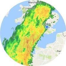
The probability of snow based on GEFS as you can see it’s quite high. Over 75% in London. Highest across Wales and SW England. Snow is very likely with risk of disruptive snowfall.

21
32
240
Well I think this is what you have all been eagerly waiting for. I’ve enjoyed making this forecast immensely, my winter forecast for 2020-21 it is a biggie, please like and share!
26
37
240
A cold and wintry Xmas period on GFS 12z this evening.

16
19
236
My summer forecast for 2023 is published. Warm and unstable is the theme. I think it will appeal to a wide range of interests. Hope you enjoy! Please share, I've had to abandon enjoying the lovely weather preparing it. 😀

22
49
240
Today marked first 5pm sunset since October 30th, the darkest days are over.
6
22
240
We've lost just over 30 minutes of daylight since 20 June summer solstice, that will start speeding up now over 15 minutes a week.
33
23
232

Something is brewing?
North Atlantic Oscillation forecast from European model has broken scale… into deep negative territory.
Highly significant high pressure anomalies in N Atlantic and Greenland. This is not every few years kind of thing, last major -NAO was 12 years ago.

15
54
231
Nice Christmas present…. there’s 20,000 of you now 😁 believe reached 10,000 only last year. A big achievement thanks for following silly me, plenty more weather updates to come, I look forward to the future. Have a great day all 🥂☺️
17
3
234
I haven’t done this before but I’m taking a break from
@Twitter
sometimes you need to realise what is important, and don’t lose sight of that. I’ve been a bit deflated and it’s knocked my personal life, nope nothing to do with internet stuff. I’ll see you all soon hopefully x
64
3
223
My notifications are going crazy. Please understand I won’t be able to reply to most of these. I’ll be giving updates all throughout the event so just stay tuned. Good things come to those who wait, breath, and enjoy it, if you can!

46
9
230
Repeatedly in extended from around 21st seeing North Atlantic blocking and cold Arctic winds.
The run up to Xmas and day itself could well be wintry this year….

11
22
228
@vonderleyen
My god what a time to send this tweet. Unbelievable.

BREAKING: At least 500 people killed in hospital bombing in Gaza, Palestinian officials claim
Read more:
4K
4K
7K
11
10
219
The direction of travel is clear…
temperatures 🆙🆙🆙 proper summery spell begins this Sunday.
17
16
222
I've decided to post it today my summer forecast for the UK & Europe is live. It is my biggest summer forecast yet, there is a lot to digest.
Please like + share 😀

13
34
227
Bloody hell! It’s a rounded -6C in my part of London 😱 previous record -4.5C.

26
25
219
Precipitation which will go to swing around more extensive than expected, currently it is largely falling as a rain/wintry mix along coast. Confidence of London snow has increased. This could bring significant snowfall tonight so watch my tweets closely.

34
24
225
Never seen this in shipping forecast before a forecast for hurricane-force 12 to waters between southern coasts of SW and Brittany’s north coast.
The highest in Beaufort scale - this means sustained winds of over 74mph out in sea, this is equivalent to a low end hurricane.


14
71
219
@moniza_hossain
Oh be quiet you don’t know nothing she does have agency. Perhaps this is what she wanted.
2
0
221
Anyone suffering from “pressure” headaches? Until this week low pressure right now would have also registered as record low for November. Locally, 964mb in my part of London this is exceptionally low. However, Ciaran got pressure down to 953.8mb locally, really noteworthy in

33
22
217
A pretty cold day in far south under grey skies, generally 1-3C. Few elevated places in SW have stayed below <0C this afternoon. Sunny spells just to north of London so less cold there.
Update I’m fine, but achey and bruised my poor knees after coming off my bike, landed hard,

31
6
217
Woke up thirsty, had a look at radar and blimey practically the whole country is getting drenched, simultaneously. I’m almost impressed.

7
14
215