
Taylor Trogdon
@TTrogdon
Followers
17,436
Following
1,688
Media
3,826
Statuses
18,036
Forecast Operations Specialist/ @noaagsl , @Mizzou / @gocreighton grad. Working in the space between research and operations. Opinions in posts are mine.
Denver, CO
Joined March 2012
Don't wanna be here?
Send us removal request.
Explore trending content on Musk Viewer
#PKAtelier24xZNN
• 191285 Tweets
PKAW 2024 x NuNew
• 114848 Tweets
PAINKILLER24 x ZeePruk
• 39155 Tweets
#オールスター感謝祭24秋
• 28270 Tweets
花火大会
• 27804 Tweets
PLUTO OFFICIAL TRAILER
• 21546 Tweets
ヒロアカ
• 20001 Tweets
WALK WITH ENHYPEN IN GOYANG
• 16134 Tweets
35Y KPWxPPV
• 15839 Tweets
ファーム日本一
• 13527 Tweets
#だらだらひとりポテナゲ最高
• 12152 Tweets
#يوم_المعلم
• 11983 Tweets
PEAT X PAINKILLER
• 11216 Tweets
トガちゃん
• 10342 Tweets


Pinned Tweet

This is possibly my favorite time-lapse that I've ever taken. Watching the colors explode then transition thru the spectrum is spectacular.
102
4K
9K
I am at a complete and utter loss for words looking at Irma's appearance on satellite imagery.
1K
11K
22K

The sun is setting on a rather incredible sight across the Atlantic basin this evening.

13
563
2K
If you don't already, it's a must that you follow
@NHC_Atlantic
,
@NHC_Surge
,
@NWSMiami
,
@NWSSanJuan
and
@NWSKeyWest
as Irma evolves.
57
1K
2K

For all of the weather lovers of the world, my aunt sent me this picture from Ohio this evening. About as textbook as it gets.

47
189
1K

Will pull the pictures off my good camera when I can but this was when the tornado was at its most photogenic. What a day.

21
138
1K
The satellite imagery from the Hunga Tonga eruption is unreal. Direct your attention to the lower right. The eruption then shock wave is simply incredible.
20
359
1K
Sometimes I save imagery because it's a highly anomalous phenomenon and sometimes I save imagery because it's meteorologically spectacular.
This is both.
It's truly hard to believe we're witnessing a hurricane near Category 5 intensity in this part of the basin on July 1st.
25
184
1K
This is insane. Travel is impossible across New York City and surrounding areas due to flooded roadways. If you are at home, do not leave. Period. As life-threatening as it gets.

15
312
940
It's the last night I get to spend with my girl until post-Irma. She asks you to be safe and listen to the advice of your local officials.

47
71
892

To be clear, in this loop we have a westward moving, dissipating cyclonic tornado AND and newly developed anticyclonic tornado also moving west-southwest with a debris signature. This is so incredibly rare it’s hard to describe.
27
163
845
Let our thoughts be with the island of Dominica tonight. It just sustained a direct and devastating strike from category 5 hurricane Maria.
16
472
763
The most beautiful radar image Houston has ever seen. The last few sprinkles from Harvey have finally cleared downtown.
17
360
762
Meteorologists: take care of yourselves too. This will be a long & grueling stretch. Your own mental & physical health matters. Get rest when you can. Take small breaks physically and mentally. You and your audiences benefit from you being as healthy as possible through the event
19
121
755
Impossible to properly convey the scale of this event. The full extent won't be realized for days. Buffalo Bayou cresting 14' above record.

28
895
683
This needs to be elevated. There are so many un-shareable things that get shared on twitter for no reason.
This is a perfectly shaped bear cloud. Share this instead.

It's a cloud. In the shape of a bear. It's a bear cloud!
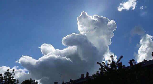
293
12K
34K
16
201
683
No saturation adjustment needed. It looks like a painting in Marco Island, FL tonight.

12
123
659
Just an incredible view of large scale flight avoidance of the massive convective system moving through the greater Chicago land area.

8
123
655
I am no authority to anyone but if you weren’t able to be productive today, it’s ok. Even if people don’t make you feel like it’s ok, it is.
18
42
619
Overheard this evening in Miami:
“I can’t feel my fingers.”
The temperature is...*checks notes*...59 F.
48
31
595
Y'all, I got my copilot back and she's happy and healthy. Dad is tired.

36
21
598
Can you, Ann? Because all I can really see is the anguish of the people that don't have homes to go back to.

You can feel the anguish of the network anchors, now that a career-
making hurricane has instead morphed into late-summer showers.
1K
488
3K
27
126
590
So this happened - Irma rescue kittens. 6 in total. Fostering for a few weeks then probably keeping two. Felt it in my heart, so here we are

55
39
582
For a smile:
Irma was exhausting and devastated south Florida but I gained two new family members because of it. A year ago I took them home very sick but they’ve recovered and are the sweetest. Then vs now.


20
36
577
Snow capped peaks with turning leaves. My mom snapped this pic and I just felt is was worth sharing to the world because Colorado is just beautiful.

18
58
586
There is no tweet that has frustrated me more as a scientist.

In the East, it could be the COLDEST New Year’s Eve on record. Perhaps we could use a little bit of that good old Global Warming that our Country, but not other countries, was going to pay TRILLIONS OF DOLLARS to protect against. Bundle up!
102K
38K
135K
28
117
559
Cyclonic and anticyclonic vorticity expressed in terms of cat.

10
63
563
Just had to give my girl to someone else for the foreseeable future. Hoping her health holds through Irma.

63
18
527
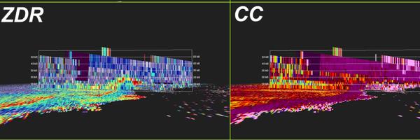
This is the most intense tornadic radar signature that I ever observed in a long time.

9
72
546
The number of people on live cameras on Key West is astounding. Please realize that your actual life is in danger.
27
147
526
Will never support this. Adds nothing to science and directly opposes the protective action we are trying to convince people to take.

We are fighting Hurricane force winds funneling through parking garage with
#stormsurge
continuing to rise in Biloxi !!
#HurricaneNate
!!
675
5K
6K
31
73
488
As meteorologists, our passion is often fueled by the awe of nature which informs our desire to keep people safe because we know it’s power. Tonight, it’s simply human. This type of event transcends awe. It’s simply sadness. This tornado has undoubtedly left a wake of tragedy.
5
102
488
It's pretty safe to say that the upcoming cyclogenesis event across the plains will be a meteorological spectacle.
Wow.
21
152
477
I can’t believe I’m tweeting this but there’s now a Moderate Risk (4/5) for severe thunderstorms including a risk for tornadoes and significant damaging winds for portions of Iowa and Minnesota.
On December 15th.
I don’t think there’s a precedent for this.

25
156
470
The most unique and incredible sunset that I have ever seen. Hands down. One that makes you just stop everything.

14
139
441
Covid vaccine envy is very real*
*also extremely happy for anyone that has been able to get it
26
36
448
The longer I go in my career, the more I realize that the ability to show empathy is one of the most important traits one can possess. It diffuses, facilitates active listening and allows people to effectively work together. Never let anyone tell you you’re weak for showing it.
16
63
459
I’m at a loss for words at the moment. I can’t recall seeing a signature like this.

21
54
450
Meanwhile in Miami - one of the more beautiful pileus I’ve seen here.

12
44
451
To this day I still don’t understand why some people make meteorology feel so inaccessible to incoming and passionate students. You can learn math; you can learn to code.
Why not just leverage that passion? That’s the one unifying quality across all of us. Don’t turn it away.
22
34
433
The long-lived, massive MCS now rolling off the Gulf Coast is best viewed from above. What an incredible view. Imagery:
@Weathernerds
6
106
427
Complete list of meteorologists that got into meteorology so they could get paid to be wrong.
11
114
431
Tonight is the one year anniversary of one of the best sunsets I’ve ever seen.

10
15
419
Letting the press ask uninterrupted, difficult questions, lending them respect, then acknowledging and coherently addressing them is something I didn’t know that I missed so deeply.
28
31
398
I’m at a loss for words. It seems that even the most aggressive models weren’t aggressive enough in Lee’s intensification.
One of the most astounding feats of the atmosphere that I’ve bore witness to.
10
76
395
I can understand a lot of societal behaviors before, during & after weather events but the sharing of fake images/videos isn't one of them.
10
77
381
This is really difficult for me but I want to share it because so many of you here have been so supportive along the way. She was the toughest kitty but she needed to rest and it was time. Rox passed late this morning peacefully in my arms.
127
3
384
And just because, an update on Rox. Unsure of the new digs, but happy and healthy in her temporary quarters.

31
5
373
In case anyone needs it tonight — a happy memory. I brought my copilot of 14 years home last year on this date after having to find her safe harbor while I worked Irma. The happiest reunion after an uncertain time.

24
14
378
A violent tornado with a path length >30 miles and ZERO fatalities.
A true testament to how far science and communications have come.
It will never be perfect but it’s important to acknowledge the successes along with the failures of the system.

Our KS storm damage survey team is back and here are the preliminary results:
An EF-4
#tornado
, with estimated peak winds up 170 mph, occurred in Douglas County, KS, and stayed on the ground for 31.82 miles, eventually lifting in southern Leavenworth County, KS.
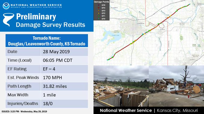
47
1K
1K
4
103
370
Not particularly excited that Irma is maintaining screaming cat status.
Had break out the shirt for self-preservation/levity.

8
75
362
Woke up and my stomach dropped. Hoping for safety and refuge for those in Ida’s path.
9
95
362
Over the course of my career, there has always come a point in every high-end weather event where I almost instantaneously humanize the implications of the forecast and it's emotional. You can't change the outcome. You do as much as you can. I am there.
10
49
361
Not sure why everyone is concerned about losing an hour when we just lost a whole year.
6
42
360
After Harvey and Irma, I'm happy to fill your feed with kitty burritos.

20
16
356
Thank you to all of the NWS meteorologists who can’t be with their families today because they’re serving the public so you can serve your turkey knowing that someone is keeping a watchful eye on the weather.
1
59
351
The Tampa radar is currently sampling incredible winds off the surface across multiple bins. About as extreme as I’ve seen.

9
94
349
Just your typical Mojave Desert sounding.
I think what's going to surprise people most is the rainfall *rate*. This area of the country just doesn't see tropical rainfall like this. Not only will it rain a lot but it's going to come down more quickly than most have ever seen.

11
87
348
One of the most difficult components of an event with little historical precedence like Hilary is that, many times, impacts are unknown and that is a nightmare for forecasters and emergency managers alike.
This will likely become the storm of record for many in southern CA.
5
98
350
I know it can be stressful/inconvenient/expensive but please try to include your pets in your evacuation plans. It was a choice to bring them into your home therefore they deserve to be accounted for if home potentially becomes unsafe.
8
68
342
Lee's rate of intensification is nearing the max that is physically possible & all hi-res guidance is suggesting that it could eventually rival some of the strongest TCs that have been observed in the Atlantic basin - time will tell. Regardless, Lee is and will be formidable.
12
115
326
There have only been a handful of storm chases in my lifetime where I’ve watched the full life cycle of convective initiation to tornadogenesis from blue sky. Storm chasing has and always will be a way to connect theory to physical manifestation. It is special.

2
15
324
Have you ever experienced Christmas lights while being in the cone of tropical system? 2020 hasn’t even peaked.


10
37
319
Guy in the elevator who sees my NWS logo:
“You guys still getting it wrong? *cackle cackle laugh cackle*
Uninterrupted, gloriously awkward silence for 19 floors.
19
17
324
A picture of my residence the past several days in all its glory.

19
15
308

Sometimes you have to take a step and marvel that we even have the predictability that we do. These cascades of energy are so complex.
10
169
293
Truly feeling for those in Irma's path - one of the strongest Atlantic basin hurricanes in recorded history.
10
205
280
What I love about what’s ongoing right now with the aurora that’s visible across what appears to be the entire US is that we are unified and captivated by its beauty. Let us try and remember that tomorrow when we can’t see it.

2
47
301
Someone just walked by me at NHC and said, "you look tired."
Fair assessment.
16
14
296
One of those very rare sunsets where you have color + texture.

7
30
291
A snapshot of the conditions currently at the hurricane center. No need to be out if you don’t have to be.
10
72
284
If anyone is needing a little strength tonight, this little she-warrior has gone through liver failure, taking a bullet and developing a condition which gives here debilitating seizures and still somehow manages to support her human.

29
14
288
Something of which I will never tire of observing. How we sense our world is under-appreciated sometimes. Beautiful vortices:

5
66
285
This is one of the more incredible combinations of winds + cold temperatures that I've witnessed, especially along the front range. Look at the gradient associated with the initial frontal push and how quickly the bottom falls out. That's an example for the archives.
7
74
288
After spending this past week at the National Hurricane Center, I just want to reiterate how dedicated every single person is to serving the public. It is incredibly tough to do what they do and I wish more people had the opportunity to be a fly on the wall.
4
36
282
On Christmas especially, I can’t help but think of all the NWS forecasters not at home with their families because they’re serving the general publics. It was always a tough one for me and think it deserves a small thank you on Christmas Day. So, to all who are working — thanks.
3
33
285
As a meteorologist, if this doesn’t turn your stomach inside out, nothing will. When I was younger, my fascination w/ extreme weather superseded my limited understanding of impacts to people. After working many & understanding the human suffering they cause, it only makes me ill.
10
51
282
Thanks to everyone who helped me out when I really needed it. Kitty has a safe place to stay.
Friends around Miami, I need some help. I have an older cat that I'm trying to find a home for while I work Irma. Any ideas, pls let me know
5
37
42
6
14
271
Thank you to all of the NWS forecasters who are spending this Christmas working to help the rest of us enjoy the holiday season safely. Weather never stops and they don’t either. Taking a moment to raise a glass to all of you.
2
26
272
This is actual insanity. If asked what the current date of this outlook was with no context, I would guess late September/early October. Please let us rest.
Signed,
Everyone

9
39
272
The imagery this hurricane season continues to make me emotional knowing what is about to be experienced.
Let's be ready to help.

11
121
268
It's hard to overstate how extreme the upcoming wind event forecast is. At 700 mb (~10k ft), winds are forecast to be 90-100 kts (~110-115mph). When downsloping occurs, much of these winds will be realized as the air descends. Gusts along the front range above 100mph are possible

10
65
268
As a final thought, the best way I can encapsulate how amazing Rox was is to describe how she made others feel. She converted so many non-cat lovers to either cat lovers or, at very least, Rox lovers. She brought joy to so many people. Ending w/ my favorite pic of her:

43
4
272
Broadcast and operational meteorologists are partners. Each has the same motive — keep the public safe — and we rely on each other equally; one is not above another. If you demean the other, you’re doing it wrong.
3
36
269
The resources, energy, skill and compassion it takes to rescue 13,000 people.
These are your heroes.

BREAKING: Federal and local agencies say they have rescued more than 13,000 people from Harvey in Houston and surrounding areas .
41
2K
3K
5
98
261
Even though I barely knew her, I loved her. Irma passed away at the vet. Sometimes you just have a connection from the beginning.

86
4
259
Whatever happens with Florence and the rest of the tropical season, know that there’s an incredible network of people that have dedicated their careers to serving the best interests of their publics. Remaining calm while taking the threat seriously is the best thing you can do.
7
45
262
I will say that it is an eerie feeling driving around downtown Miami seeing every business boarded up. My first time through this.
24
41
253

Preview of downtown Miami Wednesday morning as lows drop below 60.

18
57
248