

Nathan Howes TWN
@HowesNathan
Followers
6,861
Following
4,839
Media
9,628
Statuses
33,721
Digital reporter at @weathernetwork . Former @MetrolandMedia reporter, @TheSheridanSun editor. @SheridanCollege print-journalism graduate. nhowes @pelmorex .com
Oakville, Ontario
Joined May 2009
Don't wanna be here?
Send us removal request.
Explore trending content on Musk Viewer
#音楽の日
• 1233102 Tweets
#音楽の日
• 1233102 Tweets
BELLELIEVE BIRTHDAY CONCERT
• 157442 Tweets
ダンス企画
• 108077 Tweets
THE TASTE TIME LIVE X BUILD
• 105379 Tweets
中居くん
• 67724 Tweets
FAYEYOKO WATCH BLANK
• 41048 Tweets
中居さん
• 29547 Tweets
#国民的アニメの祭典
• 26539 Tweets
ジェシー
• 24452 Tweets
Two for all
• 24137 Tweets
トラジャ
• 22663 Tweets
佐久間くん
• 22626 Tweets
SMAP
• 20197 Tweets
マイケル
• 20147 Tweets
KEYTALK
• 20033 Tweets
Onana
• 19627 Tweets
夜空ノムコウ
• 17385 Tweets
SOTA
• 16709 Tweets
İzmir
• 14366 Tweets
محمد الضيف
• 13244 Tweets
Paolini
• 13026 Tweets
三浦大知
• 12295 Tweets
日本のソシャゲ
• 12256 Tweets
#勇者イレブン登場
• 11907 Tweets
ダンス対決
• 10716 Tweets
サザエさん
• 10425 Tweets


Pinned Tweet

This is crazy. This just happened less than 2 hours ago. Two cargo ships collided in the
#WellandCanal
.
@Welland
@WellandTribune
. Video courtesy of Jeremy Barton.
1K
4K
9K
A
@weathernetwork
viewer/reader uploaded this spectacular shot of the Friday tornado near Blaine Lake, Sask., to our photo gallery. 📷: Patty Booth.
#SKstorm
#SKwx

12
121
676
Additional footage of the cargo ship collision in
#WellandCanal
@wellandcanal
has surfaced. This shows more of the aftermath of the impact. Video also from
@j_barton84
, plus Alex Stewart. Warning: Foul language.
@Welland
@WellandTribune
@Niagara_411
30
205
310

A friend sent me this. This is pretty funny. I’m sure this has been posted elsewhere. I guess someone was upset about the
#NorthernLights
in southern Ontario.
#ONwx

22
51
233


Update from
@CANADAquakes
: A series of earthquakes has occurred in northeastern Alberta. The largest, a magnitude 5.8
#earthquake
, was preceded by two M5.2 earthquakes and followed by several felt events. If the 5.8M stands, it will be Alberta's strongest earthquake ever!
#ABwx

20
106
186
#FionaPEI
damage pictures from Charlottetown this morning. Lots of downed trees and power lines. Shingles off roofs. Photos sent to me from my friend, Jessica.
#Fiona
#ATLstorm
#Fionahurricane
#PEstorm


5
50
166
Over the past year,
@GirlsWhoChase
has grown from an
@Instagram
account to a full-fledged, North American-wide community of female storm chasers.
@jwhittalTWN
has the story on the thriving group of passionate storm chasers.
@mejenwalton
3
39
145


Thanks for sharing! Important tips for people with animals in Atlantic Canada this weekend. Details below. Please don’t forget about them.
#Fiona
#atlstorm
#NSstorm
#PEstorm
#NBstorm
#nlwx
#HurricaneFiona

@HowesNathan
@HowesNathan
We’re reminding everyone to include animals in their
#HurricaneFiona
preparedness plans, if you want to share! More tips here:

1
6
16
7
50
135

After the heartbreaking news caused by
#Fiona
this weekend, here is something positive. According to
@Sable_Institute
, the herd of wild horses on
#SableIsland
, directly in the path of
#Fiona
, appear to have weathered the storm unharmed.
#FIONA2022
#NSstorm

6
17
125
David Hart was kind of enough to submit several photos of the significant tornado near Didsbury, Alta., this afternoon to our photo gallery
@weathernetwork
.
#ABstorm
#ABwx
@NTP_Reports


1
36
131
There is a lot of snow to clear in Sydney, N.S. (and elsewhere in Cape Breton). These were uploaded to
@weathernetwork
photo gallery today. Photo on the left is courtesy of Mary Dunn. The picture on the right is from Robert Hennick.
#NSStorm
#nswx


1
30
115
This is horrific to watch. What terrifying scenery. I hope you and the neighbouring communities stay safe, Jaclyn.
#BCfire
#Kelowna

This is so bad. These winds are fierce right now.
@weathernetwork
I can’t imagine how much bigger this fire is at this time
@weathernetwork
114
595
2K
2
36
115


5
18
109
The long-awaited return of
@starsetonline
to
#Toronto
. Been a minute since the band was here. The
@TheDanforthMH
crowd was really into it (including me). Come back again soon!
@dustieboots
@starsetbrock


3
9
113
In this case, the damage extended almost 1,000 km from the Michigan border all the way to Quebec City, Que., hitting the most populated part of the country with damaging wind gusts in excess of 120 km/h, according to
@ChrisScottWx
. 📷:
@Carrie_Chisholm
#ONstorm
#ONwx

4
47
109


I think historic is (or will be) a good adjective to describe this damaging spring
#ONstorm
. A summary board courtesy of
@50ShadesofVan
that outlines just some of the occurrences from this significant event so far.
#ONwx

2
37
101

Great analysis of the
#ONstorm
#QCstorm
derecho by
@ChrisScottWx
. Derechos of similar intensity have occurred before in this part of Canada, but never has one had a track like this that followed the length of the most densely populated corridor in country.

4
40
95
One of our users uploaded this great shot of a funnel cloud to the
@weathernetwork
gallery. It was taken in Champion, Alta., on Monday. 📷: Ela Thakore.
#ABstorm
#ABwx

0
19
95


7
31
84
.
@HaltonPolice
@HRPSOak
at the vigil with its Pride vehicle to show support
#OakvilleStandsWithOrlando
#LoveWins

1
38
87
This storm is a beast. Classic anvil and cauliflower form of a beauty thunderstorm. Heading into/through
#Newmarket
area and it’s severe-warned. From
@environmentca
: Hazard: 90 km/h wind gusts, nickel-size hail & locally heavy rainfall. A tornado is also possible.
#ONstorm
#ONwx


7
26
78
People shouldn’t be littering to begin with, but dropping this on the ground in the midst of volatile, fire danger conditions and ongoing wildfires is playing Russian roulette. You just shouldn’t do it.
#NSwildfires
#nsfires

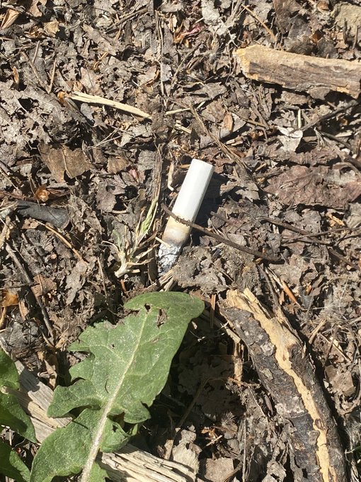
6
29
82
As
#California
experiences bulk of the atmospheric river activity, B.C. will soon get a taste. A strong low churning in the eastern Pacific has remarkable size. Over 3,000 km wide, it's on the upper end of what atmosphere is capable of generating.
#CaliforniaFloods
#BCstorm
#BCwx


5
52
84


Patience paid off earlier tonight. After seeing the flash of some lightning bolts on the other side of the house, caught some CGs across Lake Couchiching.
#SevernON
#ONstorm
#ONwx
@SevernTownship


2
9
83


I was able to get a couple of neat angles of the
#HuntersMoon
tonight (helps not taking pics off my balcony).
#FullMoon
#ShareYourWeather


4
8
74

1
3
74

Conditions may temporarily improve through overnight, but Thursday morning is projected to be the worst timeframe for air quality in GTA. Wear a N95 mask if you have one. Montreal & Ottawa will see slight improvement Thursday.
#WildfireSmoke
#onstorm
#QuebecWildfires
#wildfires

4
38
74


Ontario is not doing enough to prevent urban flooding, which is expected to worsen, says
@OntarioAuditor
. Report recommends updating building code, improving urban flood risk mapping and better protecting green and natural spaces such as wetlands.
#ONstorm

6
41
73


The
#FullBeaverMoon
pre-cloud cover earlier this evening (and pre-
#LunarEclipse
phase). Had a brief opportunity around 5:30 EDT.
#fullmoon
#beavermoon


4
18
69


.
@ECCC_CHC
has issued a hurricane watch for parts of New Brunswick and Nova Scotia. Slight possibility that
#HurricaneLee
could bring near-hurricane conditions. Hurricane conditions possible Saturday afternoon and evening. Winds gusting up to 120 km/h possible
#NSstorm
#NBstorm


3
39
65
On Tuesday, Sept. 7, a large tornado occurred in Huron-Bruce, leaving a path of destruction in its wake. The
@weathernetwork
’s
@StormhunterTWN
was on the scene and captured the moment the 'complex' supercell began showing signs of rotation
#ONstorm
#ONwx
-

1
15
64
.
@Reuters
/
@orr_photo
images show the unbelievable and devastating scenery in Earlington, Ky. — just one of many coming to light following the deadly U.S. tornado outbreak
#KYwx


0
58
65

4
23
64

Walking in a wintry wonderland ❄️. The snow has finally made it to Orillia. Big snowflakes, too. Roads are slippery. Be careful when travelling this evening.
@weathernetwork
@cityoforillia
#ONstorm
#ONwx
#SeeSnowGoSlow
1
6
52


Happy holidays,
@StormhunterTWN
. An early gift to you: A December
#ONstorm
risk map. I like the looks of this.
#onwx

4
16
59
5
4
60


Quite the light show in
#Oakville
last night. Managed to get some lightning pics from my balcony.
@weathernetwork
#onstorm


6
8
60

What a performance by
@starsetonline
at the
@OPERAHOUSETO
tonight. Would love to see a headlining show in
#Toronto
next time.


0
11
58

A lot of people have been asking me on Twitter for a Saturday/Christmas Eve travel impacts graphic. Ask and ye shall receive. Here's where the highest risks for travel impacts will be in Ontario on the day before
#Christmas
.
#ONstorm
#ONwx


3
23
58

4
8
56


4
1
58
Courtesy of
@PublicHealthON
, areas in Ontario where you are more likely to find black-legged
#ticks
in 2023. Ticks are known to reside in wooded areas or environments with tall grasses and bushes, including some city gardens and parks.
#LymeDiseaseAwarenessMonth
#LymeDisease

5
42
56


.
@NRCan
research scientist said the ground covered by the fires in Quebec's commercial forests in past four days is massive and estimates that it's equal to what was covered in past 10 years combined. Fires have overwhelmed capacity of
@SOPFEU
#QuebecFires

3
38
56

1
17
56
Smoke could significantly obstruct the sun and send air quality readings into record territory in Ottawa on Tuesday. Vulnerable folks in and near the National Capital Region and Montreal should prepare to deal with wildfire smoke.
#onstorm
#ONsmoke
#MeteoQC
#QuebecFires
#ONwx

4
31
55
Wow, this is looking nice. Love the leading edge of the cell pushing further west across
#Mississauga
, getting closer to
#Oakville
.
#ONstorm
#ONwx

4
8
56


Yikes. Photo was taken in Ottawa earlier today. The eerie, smoky scenery is more reminiscent of a heavily polluted city from India or Qatar, for example. 📸: Tessa.
#OttoApocalypse
#OttWeather
#onstorm
#ONsmoke

5
8
56
Updated (approximate) power outages as of 11 a.m. ADT.
@nspowerinc
reporting more than 126,000
#NovaScotia
customers in the dark currently, while
@NB_Power
reporting more than 37,000 people in the dark in New Brunswick.
#NSstorm
#NBstorm
#HurricaneLee

0
38
54


The snow has reached the
#Oakville
/
#Mississauga
border. Let the potentially epic snowstorm begin in
#Ontario
. Prepare for rapidly deteriorating conditions and reduced visibilties through the overnight period
#ONstorm
#ONwx
4
6
52
