

Postholer - GIS Resources
@postholer
Followers
738
Following
2K
Statuses
1K
GIS, Interactive & Printed Trail Maps, Data Books, Trip Planners, Snow, Wildfires, Gear Lists, Open Source. Portfolio: https://t.co/tARZ3syM4P
Crescent City, California, USA
Joined April 2009
@bscholl Blake/BoomAero, you folks need an account over on so we can follow you there. Thanks!
0
0
0
0
0
0
@USGSLandsat Hey, @USGSLandsat you need to be on bluesky as well, so we can follow you over there, too!
0
0
0

Polymarket is not 1 person 1 vote, it's 1 dollar 1 vote. How many dollars do you have? @sentdefender is clearly keen to do whoever's bidding, ruzzia, iran or whoever stands to gain the most by an artificially inflated poll. From now on, every time @sentdefender mentions a polymarket poll, reply with a meme to degrade his channel numbers.
0
0
1
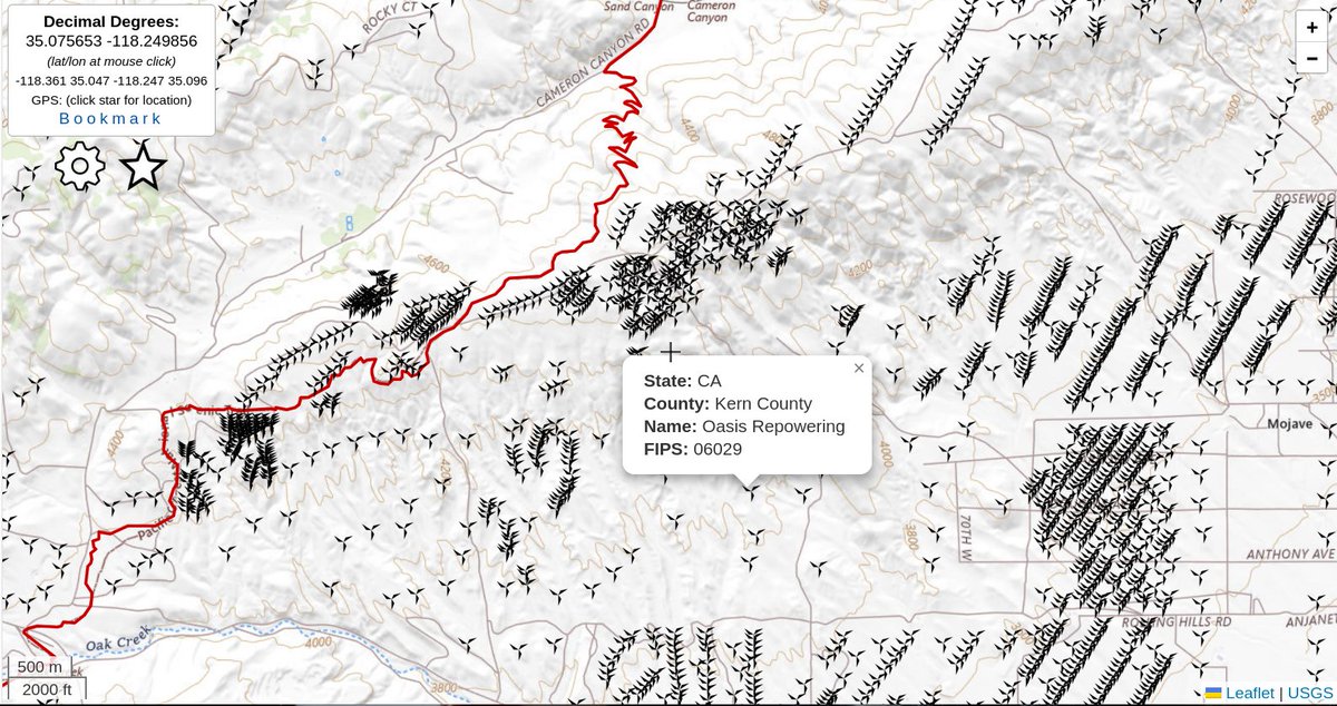
Wind turbines, the good, the bad and the ugly. Zoomed out you get clusters of turbines, zoom in for individual turbines. Mouse over or click turbine for more info. We've added wind turbines to our data on Postholer Interactive Maps. It's surprising how many there are, not just along the trail. With that said, the on trail turbines near Tehachapi Pass on the #PacificCrestTrail have really exploded in growth over that last few years. #hike #gis
0
0
2
@Erdayastronaut SLS primary objective is keeping engineers employed and vendors vending. Once you accept that, the reason for SLS in the first place is clear. The moon, Orion is all secondary.
0
0
0
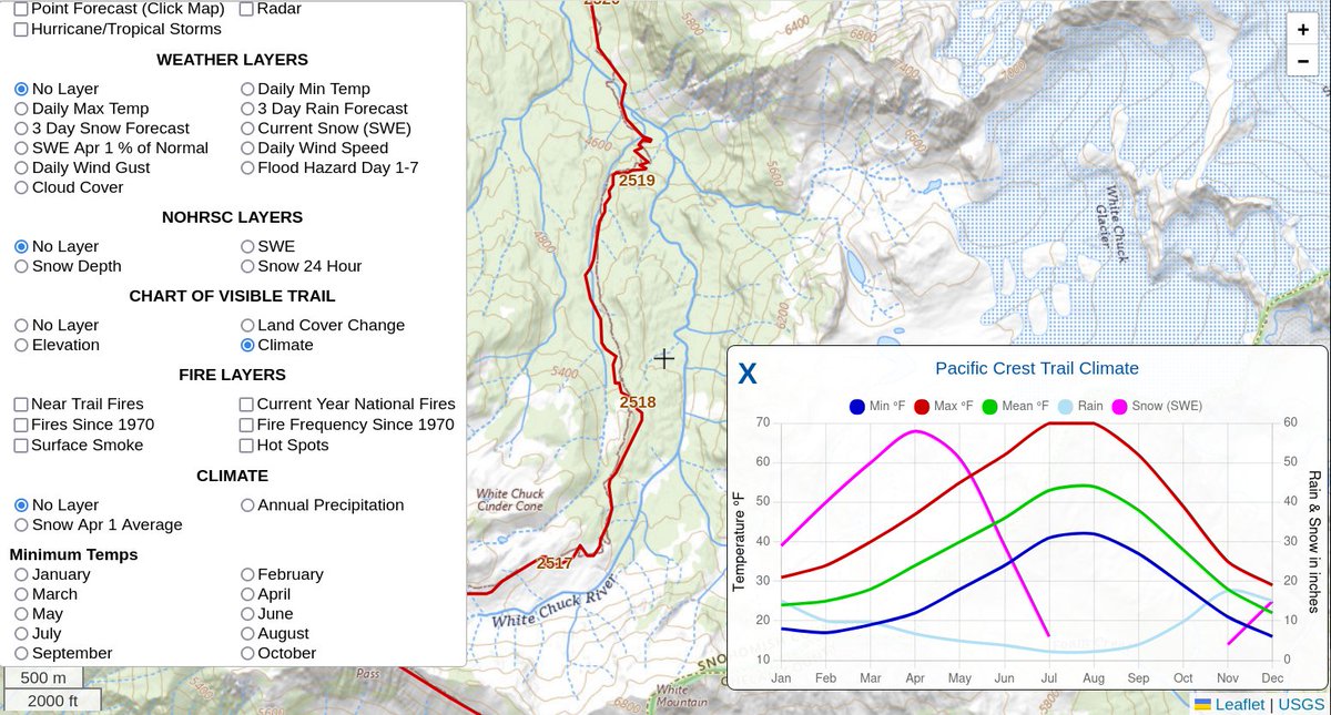
Get trail climate in chart format along any section of your favorite trail. Pick your favorite trail: Click the 'Gear Icon', under 'Chart of Visible Trail', select 'Climate'. Pan/zoom to your desired location. Our latest feature will allow you to pan/zoom the Postholer interactive map to any place on the trail and get precise climate information, at any resolution. It includes min/max/mean temp, rain & snow (swe) for every month of the year. Curious what climate looks like for the first 20 miles of the trail, for any month of the year? Perhaps, the snowiest 5 mile section of the trail? Images for both are below. Have fun! #prismClimate #NOHRSC @NOAA #gis #hike #PacificCrestTrail

0
2
6
Tale of the Trail: Land Cover Change Introducing 28 years of land cover change on your favorite trail! This is the latest feature added to Postholer Interactive Maps. It's made possible by @USGS and Multi-Resolution Land Cover Characterization Consortium, which produces the National Land Cover Dataset or just NLCD. We've had current year land cover in the online data books for years. This is different as you can actually see the on-trail change from 1985-2023 at very high resolution, about 30 meters. To use it, go to your favorite trail map, click on the 'Gear Icon' and select 'Land Cover Change' under 'Charts'. You can also display the most current (2023) land cover base map. Select 'Land Cover 2023' under 'Base Maps' at the very top. Now, every time you pan or zoom the map, the graph will update with historical land cover only along the visible trail. Pan to your favorite section of trail and zoom all the way in if you like to get precise land cover history. Here's an example link to the entire Pacific Crest Trail. Zoom and pan to your heart's content! Note, only land cover directly on the trail is used, not land cover close to the trail. We think this feature will be very handy for trail managers, trail maintainers and anyone who has an extended interest in the trail. @USGS_EROS #LandCover #PacificCrestTrail #NationalScenicTrails #gis


0
0
0
Tale of the Trail: Land Cover Change Introducing 28 years of land cover change on your favorite trail! This is the latest feature added to Postholer Interactive Maps. It's made possible by @USGS and Multi-Resolution Land Cover Characterization Consortium, which produces the National Land Cover Dataset or just NLCD. We've had current year land cover in the online data books for years. This is different as you can actually see the on-trail change from 1985-2023 at very high resolution, about 30 meters. To use it, go to your favorite trail map, click on the 'Gear Icon' and select 'Land Cover Change' under 'Charts'. You can also display the most current (2023) land cover base map. Select 'Land Cover 2023' under 'Base Maps' at the very top. Now, every time you pan or zoom the map, the graph will update with historical land cover only along the visible trail. Pan to your favorite section of trail and zoom all the way in if you like to get precise land cover history. Here's an example link to the entire Pacific Crest Trail. Zoom and pan to your heart's content! Note, only land cover directly on the trail is used, not land cover close to the trail. We think this feature will be very handy for trail managers, trail maintainers and anyone who has an extended interest in the trail. @USGS_EROS #LandCover #PacificCrestTrail #NationalScenicTrails #gis
0
1
4