

Matt Flournoy, PhD
@mattnado
Followers
1,833
Following
417
Media
798
Statuses
2,429
I study things that spin. OU/PSU meteorology alum | ⚽️ 🎹 🍻😸 🧋| pollinator lover, squash bug hater. he/him. Selfish: all opinions are my own.
Joined October 2012
Don't wanna be here?
Send us removal request.
Explore trending content on Musk Viewer
RENJUN
• 257966 Tweets
からちゃん
• 192289 Tweets
STRAY KIDS BOYBAND LEGACY
• 116742 Tweets
Steelers
• 107155 Tweets
Dodgers
• 87840 Tweets
Padres
• 87213 Tweets
Fields
• 60280 Tweets
Cowboys
• 56842 Tweets
斉藤慎二
• 39036 Tweets
書類送検
• 35398 Tweets
斉藤メンバー
• 33685 Tweets
ジャングルポケット
• 32935 Tweets
#ドンキで見つけた
• 28173 Tweets
G DE GARIME
• 26986 Tweets
Women Empowerment
• 26692 Tweets
#FinalLaAcademia
• 26258 Tweets
Chilpancingo
• 24823 Tweets
燭台切光忠
• 23045 Tweets
ロケバス
• 18533 Tweets
Profar
• 17474 Tweets
ダルビッシュ
• 16544 Tweets
#DALvsPIT
• 14633 Tweets
Alejandro Arcos
• 14157 Tweets
性的暴行
• 12034 Tweets
斉藤さん
• 11565 Tweets
#ドミノでトリックオアチーズ
• 11481 Tweets


Some incredible science was just done near Imperial, NE. Launched windsondes into a vorticity river feeding into this mothership minutes before a tornado formed. Here’s a top-down view of one of the sondes’ trajectories...
#TORUS19
#newx
@Rachel_Leigh93
@VortexMavCam


10
71
305
No one actually believes the hodograph predicts reflectivity shape… right? Please tell me this is a joke.


12
17
252


Officially Dr. Flournoy! Thank you to my advisors, committee, friends, family, and too many others to name. You all know who you are. No thanks to Diego who earned his honorary PhD today while participating in my defense. Cheers! 🍺


23
0
198


Learned a lot about graduate students today from Howie! They “don’t like dynamics anymore” and “don’t like to be interrupted”. They “hate derivations” and are so “sensitive to speech” that he “can’t make puns anymore”. Ultimately, “students have changed. [He] hasn’t.”
#AMS2023
23
7
195
Today is my first day walking into the National Weather Center as a federal scientist at NSSL. This is kind of a “return home” for me, as I was raised at the lab in grad school and worked there and at CIWRO for a couple years post-PhD. (1/3)

2
3
189
The Norman weather community is really incredible. I'm grateful for all the opportunities/support from CIWRO, NSSL, and the School the last several years. And... excited to let folks know that next month I'll start with
@NWSSPC
as a Techniques Development Meteorologist! 🙂🌩️🌪️
22
7
182
Very happy to share that today is my first day as a research scientist at CIWRO! I'm working with the Severe Convection and Radar Team on atmospheric things that spin. Very excited to be a part of the group and to keep collaborating with the Norman community! 🌪️🌪️🌪️

16
4
163
Can you trust the NWS during the shutdown? Yes.
Now for a serious question - can we please not wear Accuweather lanyards at the AMS Centennial?
4
9
157


Norman community (and everyone who sees this), please direct as many negative thoughts as possible in the direction of this cell. Thanks in advance.
7
6
135
My application for affiliate assistant prof at
@UofOklahoma
has been approved! Happy early birthday to me 🙌🏼🎉 Excited to continue working with
@ousom
and the community in this new role!
11
0
129
12z --> 19z in Norman. The cap ascended around 500 m in 7 hours, which comes out to around 2 cm/s. Textbook background lift + steady warming/moistening = rapidly eroding cap.
And just to clarify, while this is very cool, I am also very annoyed. Bad atmosphere. Bad.


3
8
118


Brief 🧵 on one aspect of tomorrow's setup. Here's a smattering of profiles at 00/03z at different spots in OK ahead of the QLCS. Ridiculous shear, especially down low. We know that line-normal shear can be important. Line-parallel shear is important too!


1
26
108
***whispers into the void*** hey guys, I think I have a wonderful idea.

7
0
107
The government’s advice on participating in the anti-racism AMS training is... to not. This is absolutely unbelievable.
7 days.


8
27
103
Three adjacent counties, three adjacent supercells, three very different mesos along an effective warm front. One likely producing a strong tor, one maybe nontornadic/weakly tornadic, and one nontornadic. Thermo more supportive southward, kinematics more supportive northward.
3
9
100
If there’s one forecast that’s always right, it’s that the atmosphere will continue to find ways to humble you. Lots to learn.


0
6
89
Storms like these represent the “swiss-cheese” disaster model. Multiple factors lined up for this to happen… 1) very broad, very supportive environment, 2) relatively early, strong, and discrete initiation, and 3) clean inflow essentially the entire time.
3
12
87
Somehow I defend my dissertation in a week! It will be on Zoom next Wednesday (July 22) at 1pm, and I will talk about supercells, tornadoes, and their environments. If you are interested, please let me know and I will send you a link!

9
3
84

I always like to ask my students, "what can go wrong with this setup?" Usually makes them address the forecast from the opposite side and adjusts their confidence accordingly.
Tomorrow is an example of when the answer to that question is... 🤷♂️. Struggling to find pathologies.
3
11
84
When your PhD federal employee friend applies for unemployment and to be an Uber driver you start to think a lot more about working for the government one day.
1
8
81
Impromptu briefing in the NWC on today’s local severe weather threat, led by our fearless leader, Tom Galarneau.

1
5
81


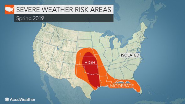
“AccuWeather predicts there will be 1,075 tornadoes in 2019.”
If there are exactly 1,075 tornadoes in 2019, I will actually wear an AccuWeather lanyard at the Centennial.

AccuWeather projects a higher frequency of severe weather risks in the traditional Tornado Alley this season. The states to be impacted the most will include Oklahoma, Kansas, and parts of Texas and Nebraska:
56
151
241
2
0
73

Some reasons why the timing of today's severe threat in OK is... "yes". At first glance, this might look like a "classic loaded gun", but the very moist and rather deep boundary layer yields MLCIN of TWENTY TWO J/kg. That's not holding much back in the way of initiation. (1/2)

1
2
67
Brief rant: can we please amplify social scientists’ voices on
#wxtwitter
? It’s a great space to discuss things, for sure. It’s just kind of exhausting seeing physical scientists talk about how the public does/should react to tornado outlooks/watches/warnings.
3
8
66
Oh hey look it’s my AMS presentation from earlier today.


3
2
64
I'd love to see the 'if' statements for this. Almost always opens the sector that I want, even if I click on the spots where 37 of them overlap.

3
1
63
Something I've been dabbling with lately: automated observed supercell tracks. Nothing too fancy... uses some thresholds on MRMS mid-level AzShear to track objects during the previous convective day. Kinda cool seeing this the morning after bigger events. *Work in progress!*

0
1
65
Great time chairing a session with Alan Sealls and
@JaniceHuff4ny
giving advice to aspiring meteorologists at
#AMS2018
. If you ever have 60 seconds left in your session and need a question answered, these two are your people.
@AMSStudentConf

1
0
62

If you like supercells, then a new paper in MWR might be of interest to you! We used a few idealized supercell sims to look at how overall evolution and behavior changed when the strength of convection initiation was weaker/stronger. (quick 🧵)

1
9
62


Gonna start making a list of when discrete updrafts, sometimes with developing mesocyclones, move into an environment with STP > ~5, and die.
5
1
60


Just realized that after 21 years of classes, I submitted my last homework assignment today. I won't miss it 😎
3
0
55
It's always a good day when page numbers come in! Brief thread on "A climatology of cell mergers with supercells and their association with mesocyclone evolution", now available in MWR.
Co-authors:
@tlyzawx
,
@satriomartinwx
, Maddy Diedrichsen,
@mconwxdr
, and
@waugh
(thank you!)
3
6
54

Life update: with the dissertation done I'm excited to start working at
@OUCIMMS
as a Pete Lamb postdoc! I'll work on much of the same: supercells, tornadoes, and their environments. The main difference is that now I have two personal assistants instead of one.


1
0
53
That afternoon paper acceptance feeling. 🥰🤓
Thanks to
@tlyzawx
,
@AWade10
, and
@janfisch15
for the support on this one. More details later!

4
1
50
All okay over here. Way too close for comfort, and hope everyone’s okay…


0
0
53
Happy Birthday to our big boy, known by many as Diego and a myriad of other names depending on his mood. I can’t believe you’re seven 🥺😻 cheers to many more years of being the overgrown kitten that you are.

2
1
53
Conclusion: … neither? Weird internal storm evolution? I have no idea. But will happily take a destructive-tag SVR warning over the other thing I thought would set my phone off.
Normanites, continue sending bad thoughts WSW.
In all seriousness, this has an established meso moving into a double-digit STP environment. Hoping for sub-optimal (i.e., EXCEEDINGLY OPTIMAL) storm-scale interactions, or some mesoscale process that warrants extensive research.
0
1
39
0
0
51


A comment on the sensitivity of SRH to what you want to call "the bottom of the layer". NSSL sounding on the left from Geary at 20z (from
@MesonetMan
/
@NOAANSSL
) and on the right from Norman at 21z (from
@NWSNorman
). Double the SRH in Norman?! WOAH! But if you look closer... (1/3)


3
3
52

@jeremy_gibbs
Couldn’t agree more. Being proud of “the students have changed, but I haven’t” is something I can’t wrap my head around.
0
0
48
Do NOT like the look of these reflectivity signatures down by Lawton. Whether it’s mergers increasing updraft size, or just that a few of these updrafts developed in a local convergence max, I worry about the next hour or so if a dominant meso forms out of this.
2
3
50


Time for an AMS presentation thread! This may be of particular interest to anyone interested in supercells, tornadoes, their background environments, and warning performance. And Schitt's Creek. And I'm sure one of my destructive cats will make a timely appearance. (1/4)

1
4
47
New paper in
@MonWeaRev
is out on early online release! Thanks to the coauthors for helping analyze variations in supercell tornado potential in different environments. Check it out here:

1
4
42

Announcement from a regular gym-goer to all first-timers: you keep doing what you’re doing. You’re inspiring and you got this. You stay on that equipment and do an extra set. I’ll gladly wait.
#TuesdayThoughts

I absolutely hate the gym the first couple weeks of January. Appreciate all the people trying - but you’re taking up all the equipment!
#TuesdayThoughts
8
1
33
1
4
45
Honored to have witnessed this in person and excited for everything that women will accomplish at
@NWSSPC
in the future! 🙌🏼🙌🏼

1
0
45


Couldn’t agree more. The other important takeaway is that Howie’s (the certain professor) opinions are not general among professors. At all. Graduate students at
@ousom
and beyond are remarkable; there’s evidence of that enough at
#AMS2023
. Keep up the great work. 😊

Seeing tweets about some *interesting* comments from a certain professor about "students nowadays". I'll just say, if you refuse to accept that different people learn things in different ways and adapt your teaching methods accordingly, you shouldn't be in a classroom. Full stop.
5
4
136
0
4
43
Very brief pressure drop (~ 3 mb) from the backyard station as a weak tornado moved by to the south. Guessing we were very near (or… in) the outer limits of the circulation, thankfully on the side opposing forward translation.

1
3
42
This. Educate yourself. And god forbid if an expert CORRECTS you (say what?!?!), maybe take the 10 seconds to, I don’t know, publicly acknowledge it and correct your prior tweets. Lots of followers = more responsibility to promote science based on data, not personal musings.

I am once again asking meteorologists to consider that social science is not something you can ignore in favor of making broad assumptions based on single anecdotes
And for the love of God please read a few papers on wxcomm, PLEASE
4
10
121
2
1
42

6
23
43


Not complete yet, but check out this automated mesocyclone tracking technique! It uses MYRORSS azimuthal shear, and the goal is to provide a first guess of past/ongoing supercell tracks. Figured if it works alright on April 27th, maybe it's got a chance at being useful 😅
1
6
41
In all these solutions, 0–1-km shear is huge (scientifically put) but also oriented mostly PARALLEL to the QLCS. How does this impact the potential for mesovortices and tornadoes? It can feed streamwise vorticity directly into the low-level mesovortex.

1
2
43
I'm very honored and humbled to receive this award! Thank you to everyone involved in the
@ousom
selection process, and especially to
@mconwxdr
and Twitterless Erik for putting up with me. They probably deserve an award for that too. Cheers! 🍻

Next up, we have Matthew Flournoy!
Matthew has received the 2020-2021 Faculty Recognition for Outstanding Performance as a Graduate Student. Way to go!

0
1
27
1
0
40

Check out some of my dissertation work just published in
@MonWeaRev
! If supercells, tornadoes, and their environments pique your interest, this is for you.
1
6
36


Cheers to four years of Mattenzie! You’re my forever and I can’t wait to keep doing this thing called life with you. You make it all worth it. 😊


0
1
39
Normanites, continue sending bad thoughts WSW.
In all seriousness, this has an established meso moving into a double-digit STP environment. Hoping for sub-optimal (i.e., EXCEEDINGLY OPTIMAL) storm-scale interactions, or some mesoscale process that warrants extensive research.
0
1
39
Watching dews in central TX and seeing some CAM dry biases, particularly along the Edwards Plateau. 12z suite maintains 40s dews there until 16–17z. Current surface obs already show decent moisture there surging north. (ugh)


2
4
38


Congratulations, Dr. Krocak!! If completing your general exam during a government shutdown and defending your dissertation during a pandemic isn’t kicking PhD ass, I don’t know what is. So proud of your massive successes and to call you my partner. Congrats, babe 😊


0
0
37
So in summary, there will be a huge component of low-level shear tomorrow that *isn't* line-normal. And that can have a significant impact on the tornado threat. See Flournoy and Coniglio (2019) for more details 🙂 and thanks to
@tlyzawx
for the Euro sounding (I'm cheap)
1
0
39
Starting Friday off strong with a paper acceptance in
@MonWeaRev
! Thanks to anti-social-media Erik Rasmussen,
@ClarkEvansWx
, and reviewers for guiding this one along. General idea is how initiation strength influences supercell evolution, coming to a
@MonWeaRev
issue near you! 🙌🏼
2
2
35