
Matt Hoffman
@matthoffmanwx
Followers
4,205
Following
3,063
Media
19,278
Statuses
39,502
Chief Meteorologist @KDRV | Certified Broadcast Meteorologist | @IowaStateU Alum | MN Native | IG: matthoffmanwx | I love a good fun fact, brunch & baked goods!
Medford, OR
Joined August 2009
Don't wanna be here?
Send us removal request.
Explore trending content on Musk Viewer
CONFERENCE ENGLOT SERIES
• 614505 Tweets
#ShopeexNCT127_GameDay
• 138795 Tweets
Yolun
• 38571 Tweets
井上尚弥
• 36383 Tweets
Dangote
• 29271 Tweets
#月見バーガー前夜祭
• 26933 Tweets
ボクシング
• 26349 Tweets
Kaptan
• 25982 Tweets
HERE COMES THE ALPHA
• 20014 Tweets
武居比嘉
• 19713 Tweets
Samthing Soweto
• 18837 Tweets
NamtanFilm X OishiHKDcorn
• 16503 Tweets
比嘉大吾
• 15563 Tweets
Takei
• 15191 Tweets
サンライズジパング
• 11920 Tweets
CGPJ
• 11553 Tweets


What a stunning shot of the lenticular cloud show Mount Shasta put on yesterday! 😍
#CAwx
#StormWatch12
#magicmountain
🏔️
📸: Robert Renick

36
415
2K
A look at a snow-covered Mount Shasta behind the storm today! ❄️🏔️❄️
#CAwx
📸: Malou Shannon

10
179
2K
Here’s the coolest thing you’ll see today. Check out this timelapse of Mount Shasta from this past Sunday! Absolutely incredible! 😍
#MountShasta
🏔️
#lenticularclouds
#CAwx
📹: Robert Renick
23
328
1K
It was a gorgeous sunset tonight on Mt. Shasta with a nice stack of lenticular clouds. Winds were very strong on the mountain today helping to create these cool clouds.
#StormWatch12
📸: Lucas Beard

5
101
596
Here an amazing timelapse of yesterday’s lenticular cloud display produced by the one and only Mt. Shasta. 🏔️ This one sure looks like a 🛸. So cool!
#MountShasta
#lenticularclouds
#CAwx
📹: Robert Renick
8
106
481
A look at the
#RumCreekFire
early this morning with a meteor streaking through the sky. A stunning but scary photo.
📸: Jasman Mander

3
65
280
A waterspout was spotted earlier today near Gold Beach. This photo was taken just north of town and was reported to be moving northeast. Bo said the waterspout touched down just about a mile offshore and churned up a lot of water.
#ORwx
📸: Bo Shindler

5
52
279
Haley: Mom, can we drink now?
Claire: Honey, it's lunchtime.
Haley: Ohhh..
Claire: That's a YASSS!
So glad
@ModernFam
is back! LOL!
0
78
210
Another gorgeous view of the lenticular clouds above Mt. Shasta today taken along the Ski Park Highway. 🏔️
#CAwx
#StormWatch12
📸: Robin Kohn

4
36
219
A stunning view earlier tonight taken in the Shasta Valley of the
#MillFire
(3,921 acres) on the left of the photo and the impressive
#MountainFire
(1,464 acres) on the right. Both are 0% contained tonight.
#FireWatch
#CAwx
#StormWatch12
📸: Road Shots Photography

6
69
212
So let me get this straight...it's
#PancakeDay
,
#NationalPizzaDay
&
#PaczkiDay
? Wow, it really is
#FatTuesday
...
5
199
187

I'd like to thank our director Eric for getting
@britneyspears
', "Oops I Did It Again" stuck in my head this morning.
2
54
149
A lightning strike and a rainbow together in Big Springs down in Siskiyou County this evening.
#StormWatch12
📸: Sarabecca Barnett

3
28
157
Just discovered the full-album cover by
@TheRyanAdams
of
@taylorswift13
's
#1989
album. Wow! Both are so good!
#youngSpringsteen
#onrepeat
0
19
137
Mt. Shasta stacking those lenticular clouds today! This photo was taken near Klamath Falls. 🏔
#StormWatch12
📸: Alan Ertle

2
14
146
Here's the view of the
#LavaFire
from Mt. Ashland this evening and the big pyrocumulus cloud that made it thousands of feet into the sky.
📸: Kathleen Kinzie

2
31
140
Here's a photo from around 8 PM tonight looking south from around Roxy Ann Winery in
#Medford
. The Rogue Valley Manor can be seen on the bottom right. An update on this fire coming up @ 11.
#FireWatch
📸: Austin Pena

12
75
136
Check this out! The
#NorthernLights
were even captured last night in Northern California. This timelapse video was captured up at Castle Lake with Mount Shasta there in the distance. Beautiful!
#CAwx
#AuroraBorealis
#ShastaClouds
#StormWatch12
✨
📹: Casey Codianne
1
31
124
This is an incredible view from Klamath Falls of the pryocumulus being produced by the
#LavaFire
today near Weed. I'll have an update on where the smoke is heading and fire weather conditions in the days ahead coming up @ 6.
#StormWatch12
📸: Chuck Collins

3
41
114
The clouds parted today in between storms making for this stunning view of Mt. Shasta! The mountain will get much more snow in the coming days. ❄️🏔️❄️
#CAwx
📸: Mel Fechter

2
18
122
Pretty cool view for this meteorologist flying over the Rockies on the way to my layover in
#Denver
. 😍🤓

3
15
112
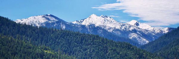
What a beautiful look at all that snow around and on top of Mt. Shasta earlier today! 🏔️
📸: Shannon Turner

1
10
101
Here’s a look at the
#SmithRiverComplex
that shut down Highway 199 in Del Norte County, CA. This was taken at about 2:30 pm just before the highway was closed.
📹: Kim Olin
4
30
96

Beautiful and sad all at the same. This photo was taken in land burned by the
#AntelopeFire
in Siskiyou Co., CA.
📸: Jenn Costales

3
19
93
Mt. Shasta looking beautiful in black and white! This was taken yesterday. 🏔️
#MountShasta
#CAwx
#lenticularclouds
📸; Don Hasemeyer

4
9
90

Mount Shasta was putting on a show today with lenticular clouds. The clouds are a sign of the incoming winter storm on the way. Here's a shot of the mountain this evening at sunset. So pretty! 🏔️
#CAwx
#StormWatch12
📸: Robert Renick

2
11
83
The satellite loop of the pryocumulonimbus from the
#BootlegFire
is just unreal this evening. It's become a whole cluster with more cloud-to-ground lightning being detected by radar too. This extreme fire behavior has also helped to merge the
#BootlegFire
and
#LogFire
.
5
33
80
This week marks 3 years here at
@KDRV
! The time sure has flown by since I moved out west, but I love it out here. 🌲🏔🌲 Thank you to all the viewers in Southern Oregon & Northern California for watching and letting me into your homes each night with your weather forecast. ❤️

12
0
74
As a meteorologist, on a quiet weather day, walking care-free into the newsroom on an
#ElectionDay
.
3
2
72
Here’s video of another waterspout that happened today. It happened around 7:30 p.m. near Brookings.
🌊🌪️🌊
#ORwx
Ilyse Sheppard who captured this video said the waterspout lasted over 10 minutes. She said this was a once in a lifetime experience. I would definitely agree!
4
22
68

Check out this beautiful view of Mt. Shasta sporting a lenticular cloud over the summit. The mountain will see several inches of snow tonight. ❄️🏔️❄️
#StormWatch12
#MountShasta
#CAwx

1
6
67

My biggest concern while doing this whole working from home thing...are people judging my home decor? 🤔

14
1
64
Wishing my friends at
@KTVL
the best on their last day on-air today and tonight. It’s a really sad situation for Southern Oregon and Northern California, but there’s a bunch of stations that are going to be getting some great journalists and meteorologists. 💛
2
4
62
It was quite the lightning show last night up in Bandon as storms rolled through the region. Some amazing lightning captured here! ⚡️⚡️⚡️
#ORwx
Unfortunately, we’re also tracking a bunch of new fires in the region from storms the last few days.
📸: Mark Grissom

0
17
62
A river of water and hail at the Charles Point Apartments in South Medford from the storm. 😳
📹: Anna Back
3
10
63
Let it be known here that I was once somebody special and didn’t have to pay for it. 🙄

10
0
61
Absolutely, breathtaking. 😲 This is a photo taken yesterday of
#MountShasta
. I just love this mountain so much. Wow! 🏔❤️
#lenticularcloud
#NorthernCalifornia
📸: Lori Eckhart

2
6
58
The first peeks of Mount Shasta after the winter storm tonight just before sunset in Weed, CA. 🏔️
📸: Elizabeth Carrillo

1
7
56
This was the view on Friday from the lookout in Hellgate Canyon as the
#RumCreekFire
was exploding in growth to the northwest in Josephine County.
📸: Gingerly Templin

1
17
55
A beautiful view of a snow-covered Mt. Shasta this morning. 🏔️
📸: Donna Kleaver Thompson

3
8
56
Mt. Shasta telling us today that a storm is coming. 😍💨❄️🌧🌊
📸: Shannon Turner

0
3
54

Quite the show over Southern Oregon tonight. We're hearing this may be space debris and not a meteor. I'm working to get more details for you all tonight @ 11.
📹: Bryanna Wilson
5
18
52


This was looking south last night from Mt. Ashland towards the burning
#LavaFire
. The smoke almost blocks out Mt. Shasta in the distance.
🌲🌲🔥🌲🌲
📸: Jasman Mander

0
20
52
How would you like to have a funnel cloud photo bomb your wedding photos? It happened to Nathan & Anna Schneider this afternoon in Denmark!

3
21
50
Crater Lake measured a snow depth of 128” this morning. That’s a new max for the season and well-above the 100” average for today’s date. Much more snow on the way through the end of the week! ❄️

1
8
50
I don't think
@SchittsCreek
could have had a better first episode of the final season. I have no doubt that this will be the best season yet. I love this show so much! ❤️ Thank you
@danjlevy
! It’s a work of art.
#SchittsCreek
0
1
48
Mount Shasta was putting on a show this morning for my birthday. Love to see it! 🥳
📸: Lisa Hicks

2
2
46
Obsessed with this photo taken today at 1,000’ outside of Brookings. That’s the ocean in the distance. I can only imagine getting to see this beautiful view in person!
📸: Tracy L.

1
5
44
@danjlevy
@adampally
Umm so does this mean we can bring back
#HappyEndings
now? That would be ah-mahhh-zing. Please🙏🏻
1
1
44
Here’s a frightening photo of the
#LavaFire
taken last night at 11 PM from the Weed Airport. You can Mt. Shasta in the distance beyond the flames.
#StormWatch12
#fireseason2021
📸: Bill Bartlett

6
17
46

1
4
44
Well, it's happening. I'm doing weather from home now. So come on in, sit back, relax and hear about the rain and snow that's moving in this weekend. But please be sure take of your shoes and use a coaster. See you starting at 4 pm!
#StormWatch12
📱📺⛈❄️

5
1
42
Much like temperatures this week, going up...so is my hair.

6
0
43
Tomorrow is the first concert of the
@brittfestivals
in
#Jacksonville
this
#summer
. It's going to be a beautiful evening to kick off the season with
@ziggymarley
performing.
#StormWatch12

0
16
41
Check out this beautiful view of Mt. McLoughlin from the air today! 🏔
#myfavoritemountain
#ORwx
#PNW
📸: Ryan Jennings

1
2
42
The
#HeadFire
is exhibiting extreme fire behavior based on reports from fire crews and from our radar imagery. The fire has produced its own thunderstorm! The lightning can spark more fires. Acreage up to 3,000 acres and growing! Below is the view from Fort Jones.


1
9
42
A look at yesterday evening’s sunset near Mt. Shasta as this storm system approached.
#CAwx
📸: Ryan Workman Photography

1
9
40
It was a winter wonderland this morning outside of Lakeview. Just a reminder it’s June 20th! 😳 A persistent band of snow overnight dropped several inches in some spots. This home measured 5” of snow! ❄️❄️❄️
#ORwx
#summerbeginstomorrow
📸: Stace Andrews

1
13
41
What's at the end of the rainbow? 🌈 Mt. Shasta, California 🌈
#StormWatch12
#CAwx
📸: Peter Brimhall

0
3
38
Welp, it’s sure not a pond anymore! Seeing Emigrant Lake like this again makes me so happy! 🥹

3
1
40
Another RED FLAG WARNING is in place from 2 PM to 11 PM today in Siskiyou County, where several fires are burning and leading to Evacuation Orders. We have the threat for thunderstorms producing abundant lightning and gusty winds. The
#McKinneyFire
is over 51,000 acres now.


1
18
38

It can’t express how great it feels to be back in the studio again and being able to point at stuff. 👉
#StormWatch12

3
0
38
OH MY GOD!!! MT. SHASTA IS...🌋
Oh. Thank gosh...it’s just a cloud. ☁️🏔
I agree with Kathy. This is a fun photo of
#MtShasta
from the other day. 😂
#StormWatch12
📸: Kathy Howard

2
2
38
Check out this gorgeous photo of a lightning strike in the valley seen from Central Point with Roxy Ann and Mt. McLoughlin in the distance. ⚡️😍
#StormWatch12
#ORwx
📸: Michelle Hill

0
8
34
Photos of the
#SmithRiverComplex
from Highway 199 in Del Norte County, CA at around 3 pm today.
📸: Chris Sackett


1
7
35
A look at the
#AlmedaDriveFire
burning north through the Rogue Valley earlier today and now into tonight. This is heartbreaking. Be safe, everyone! Listen to evacuation orders.
📸: Don Veverka


2
9
34
Yesterday marked 10 years since I started my first job as a
#meteorologist
back in Eau Claire, WI. For the first 7 of those years in this biz, my hair was awful. But seriously, the best part has been ALL of the amazing people I’ve met & call friends all these years later. ❤️📹⛈
3
0
37


Head outside and check it out! You can see this right now.

LOOK UP: Venus and Jupiter will pass within 0.5° (approximately width of Moon), tonight! Look west after sunset! This won't occur again until 2032!

0
3
10
6
3
36

Check out this incredible sunset time-lapse video tonight of the intense
#BootlegFire
burning in the Basin. This shows today's extreme fire behavior and the pyrocumulonimbus clouds that formed. I'm scared to see the acreage report in the morning.

In case you thought my picture was photoshopped, this is a timeline of the
#bootlegfire
at sunset 🤩
15
29
145
2
9
34
It really is a nightmare.

0
9
34

Mount Shasta making stacks on stacks on stacks of lenticular clouds today! 🤩🏔️
#CAwx
#MountShastaMagic
📸: Bob Harmon

1
6
34
Some crazy lightning captured this evening at about 8:30 p.m. in North Medford. This storm took off so quickly right in the middle of the valley.
#StormWatch12
📸: Chevone Card

1
6
33

Check out this beautiful view of Mt. Shasta stacking up lenticular clouds this afternoon. This view is from Weed. 🏔
📸: Kimberly Moore-French

1
2
34
Check out the dusting of snow up at the
@CraterLakeNPS
visitor center from this morning. We really have a little bit of everything in the forecast for today in Southern Oregon! 🌧🌩🌨

0
1
33
Fire crews are going to be tested here as a strong thunderstorm has developed SE of the
#McKinneyFire
and is moving NW towards the fire. It's capable of wind gusts of 40 mph with pea size hail. Tune into NewsWatch 12 @ 5 p.m. for the latest on storms and fires in our area.
1
13
29
BREAKING: You're looking at the scene from our weather cam in Medford of a fire on the Bear Creek Greenway. We're working to get more information on the fire. The latest coming up @ 5 & 6 on
@KDRV
.

0
12
32

Wow! Right now the only way for travelers to get over the Cascades in Oregon is to basically either take Highway 58 or Highway 140. Every other Cascade highway is closed due to this winter storm.
#StormWatch12

1
9
30
Never will get tired of
#skiing
in the Rockies! Just gorgeous. My first time skiing at
@KeystoneMtn
today. It was a blast!
#journeytoOregon

3
0
32
Here’s what the Mt. Shasta Ski Park looked like today behind this latest winter storm! What a view! ❄️🏔️❄️
#CAwx
The ski park is expected to open up again tomorrow after a power outage kept it closed today.
📸: Luke Besmer

1
2
30
I am now a Certified Broadcast Meteorologist through the
@ametsoc
! I'm
#701
, and I couldn't be more excited!
http://t.co/R1GngUKcGC

9
0
30
What a snowstorm for the Klamath Basin! Here's the view from Klamath Falls. ❄️
Our weather will turn much quieter tomorrow.
📸: Riboli Terrie

0
4
29
Gorgeous view of Mt. Shasta today breaking out from the clouds. More snow coming to the mountain tonight. 🏔
#StormWatch12
📸: Julie Lorenzen

0
1
31