

GeoDataScience
@geodatascience
Followers
7K
Following
1K
Statuses
2K
Twitter feed for the Geographic Data Science Lab at the University of Liverpool.
Liverpool
Joined January 2014
Great to meet all of our new #PhDs at the GDSL away day yesterday - excited for the year ahead!

0
4
29
RT @qmrg_rgs_ibg: Are you working on spatial methods or with spatial data ? 🌎✨Consider submitting your abstract to our sponsored session in…
0
3
0
RT @LSEGeography: 🚀 Early-career women in Economic Geography & Spatial Economics - join us at LSE for WECW-EGSE (12–13 May 2025) 📊 Apply b…
0
29
0
RT @ruthneville20: ‼️Excited to be accepting abstracts w/ @GijsW4 for our session on Spatial Methods for Spatial Populations at the @RGS_IB…
0
13
0
RT @mattgmasn: Excited to welcome submissions for an ECR session at the 2025 @RGS_IBG Annual Conference, sponsored by @qmrg_rgs_ibg 🌍 We’re…
0
5
0
RT @CarmenCabArn: Interested in urban mobility, networks and spatial analysis? Then join @AndrewRenninger and me in our @Complexity72h proj…
0
2
0
RT @qmrg_rgs_ibg: Our excellent PGR reps are organising a special ECR session at this years @RGS_IBG Annual Conference. If you are an #ECR…
0
4
0
RT @darribas: 🎧 New GLaD episode out, feat. Geoff Boeing (USC, osmnx, etc.). Geoff is full of insight and entertainment, a rare pair to fin…
0
1
0
RT @fangyuan_li225: Excited to welcome submissions (250-word abstracts) for an ECR session at the next RGS-IBG Annual Conference, sponsored…
0
3
0
RT @darribas: This is the first of new and exciting jobs we're announcing for Imago, the SDR UK Data Service for Imagery. If you like worki…
0
2
0
RT @darribas: Second open post for Imago, the SDR UK Data Service for Imagery. This is for an outreach & PE officer. If you like working…
0
1
0
RT @ruthneville20: Excited to be co-convening the Computational Demography and Data Science strand of #PopFest25 w/ @athina_anas! Excellent…
0
11
0
RT @CarmenCabArn: 🎓🚨 PhD Opportunity Alert! Passionate about urban mobility, sustainability & social justice? I’m looking for students t…
0
6
0
🌍 #30DayMapChallenge 🗺️ Day 30: The Final Map @AkosBalog1 tests the coding abilities of #ChatGPT by asking it to write and execute #python code to map South Korea's high-speed rail network. For comparison, the same prompt was also used to generate an image #ai #aimapping


0
0
4
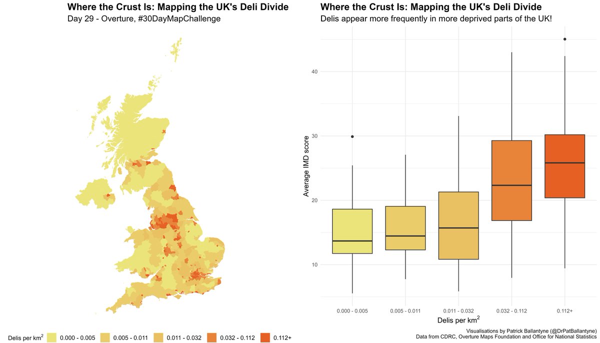
🌍 #30DayMapChallenge 🗺️ Day 29: Overture "Mapping the Deli Divide" 🥪 @DrPatBallantyne has used data from Overture (available from @CDRC_UK) to explore the geography of deli's in the UK. Code available at:
0
1
5
🌍 #30DayMapChallenge 🗺️ Day 28: The Blue Planet Steve Howe maps the waterways of England and Wales, alongside the cumulative hours of sewage discharge for each region in 2022 using data from @theriverstrust

0
0
3
🌍 #30DayMapChallenge 🗺️ Day 27: Micromapping @mattgmasn maps the buildings, green spaces and amenities surrounding @geodatascience using data from @openstreetmap
#osm #OpenStreetMap

0
0
4
🌍 #30DayMapChallenge 🗺️ Day 26: Map Projections Today we're borrowing @alexsingleton map, which shows the distortion between the Eckert IV and Mercator projections 🗺️

Day 26 #30DayMapChallenge - Map Projections Today is a quick #rstats exploration that compares areas to explore distortion between two projections - the Eckert IV projection and the Mercator projection.

0
0
2
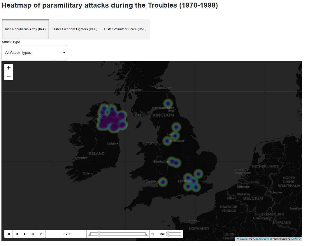
🌍 #30DayMapChallenge 🗺️ Day 25: Heat Giada Garofani has created a dashboard with a heatmap showing paramiltary attacks during the Troubles (1970-1998). Find and download the interactive dashboard here:
0
2
12
The GDSL has joined Bluesky! 🦋 Find our page here and give us a follow 💙
0
0
0
🌍 #30DayMapChallenge 🗺️ Day 24: Only Circular Shapes Alice Varley uses circles to map mental health need by deprivation in Liverpool. Colour represents mental health need (with yellow denoting higher need) and size represents relative deprivation #MentalHealth #deprivation

0
0
5