
David Koeller
@dkoellerwx
Followers
4,087
Following
1,120
Media
11,588
Statuses
22,049
WOWT Channel 6 News Meteorologist. Actually a meteorologist - always verify your sources.
Omaha, NE
Joined June 2010
Don't wanna be here?
Send us removal request.
Explore trending content on Musk Viewer
Olympics
• 1630776 Tweets
Venezuela
• 887884 Tweets
オリンピック
• 433183 Tweets
Celine Dion
• 379313 Tweets
Francia
• 303384 Tweets
Christian
• 216639 Tweets
フランス
• 198160 Tweets
Gojira
• 171888 Tweets
Last Supper
• 153458 Tweets
Beyoncé
• 89478 Tweets
パリ五輪の開会式
• 53693 Tweets
刀剣乱舞
• 46954 Tweets
マリーアントワネット
• 42899 Tweets
#Smackdown
• 34627 Tweets
Jordan Love
• 31442 Tweets
隅田川花火大会
• 28364 Tweets
Alianza
• 22249 Tweets
Packers
• 22215 Tweets
#Luca3D
• 19561 Tweets
セリーヌ・ディオン
• 16536 Tweets
愛の讃歌
• 16133 Tweets
DDAY YOU BETTA CATCH UP
• 15664 Tweets
Pumas
• 14537 Tweets
अब्दुल कलाम
• 13642 Tweets
#グラブルEXフェス2024
• 11314 Tweets
भारत रत्न
• 10863 Tweets
पूर्व राष्ट्रपति
• 10319 Tweets


#Tsunami
Watch Cancelled for Hawaii! Data shows no significant waves were generated by the M7.5 earthquake that occurred about an hour ago.


49
644
3K
Absolutely incredible display of the Northern Lights! Taken just north of Omaha. Mind blowing!


22
53
792
#HurricaneLaura
making landfall right now near Cameron, LA. Extreme Wind Warning now in place until 3am from Cameron through Lake Charles. Wind gusting to 127mph in Cameron, and 104mph in Lake Charles. Over 100,000 now without power! Eye of
#Laura
approaching Lake Charles soon!

17
279
557
A Magnitude 6.1 earthquake recorded very near the Cayman Islands in the last 30 minutes. Presumably an aftershock from the M7.7 to the east earlier this afternoon. Likely stronger shaking in the Cayman Islands from this earthquake than the earlier one.

17
494
469
I'm blown away fright now! I never imagined I'd be able to show the northern lights on this camera. Ribbon of green light pulsing and flashing ... putting on quite the show! Incredible!
10
26
443
Damage in Greenfield, IA looks very significant. This view from our severe studios partner Ryan Scholl. A very large tornado swept through the area about an hour ago

13
94
414
Hey northwest Iowa... you all alright? Not bursting into flames or anything I hope? 🤣
@TylerJRoney

22
22
280
Isolated severe storms are possible in our area this afternoon, but the greatest severe weather risk will impact Oklahoma, Arkansas and Texas late this morning into the afternoon. That's where the risk for large hail, damaging winds and a few tornadoes will be the highest.


19
125
212
This image posted by the president of Iceland from the Icelandic Meteorological Office shows the scale of the eruption right now. The town of Grindavik is in the upper right of the photo, barely 2 miles from the site of the eruption right now! Far too close for comfort...

4
71
236
Tsunami Advisory in effect for the west coast of the US and Canada. Destructive tsunami waves are not expected, but sudden and erratic changes in water levels and currents are expected later this morning along the shore.


6
145
221
This morning's... event... shall we say has officially been classified as a derecho. That means the area of severe winds stretched over 240 miles from end to end, it doesn't speak to the strength of the storms. That said, we did have an 82mph wind gust in Papillion!

5
46
209
This is some of the heaviest snow I have ever seen. True blizzard conditions right now in Midtown!
@NWSOmaha
@WOWT6News
8
47
164
Very noticeable increase in Missouri River levels between Noon and 3pm! You can see how much the water has come up into Hanafan park. All riverfront areas have been closed off in anticipation of further flooding. First image is Noon, second is 3pm.


2
20
167
Northern Lights Forecast!
Space weather forecasting is a bit difficult, so bear with us! There has been a change, the arrival of the CME has slowed some, pushing the best viewing window back to Saturday night from 7pm to Midnight. Make sure to get away from city lights!


6
46
142
Both of these pictures were taken in Nebraska today. From snow to tornadoes, and just about everything in between... any kind of weather you want! Now... who's ready for some sunshine???

2
40
140
First National Tower downtown has gone dark tonight to contribute to energy saving efforts around the region.

10
13
133
Many unbelievable sights today & devastation from tornadoes across our area. This is just one of those incredible moments... a tornado develops right on top of Eppley Airfield, then makes a beeline for one of our cameras, eventually taking out the power and/or the camera itself!
2
27
134
Now Post-Tropical (meaning technically no longer a hurricane)
#Dorian
making landfall in Canada this evening. Despite the name change, the system is still producing wind gusts up to 100mph! Hurricane Warnings in place along the southeast Canadian coast through the overnight.


11
58
122
#ICYMI
, we just played a clip of this amazing video showing fog rolling off the Missouri River into downtown Omaha this morning!
#Omaha
#Fog
@WOWT6News
2
32
132
Dream come true! So incredible.. hard any words. It's hot all the way back here!

2
2
130
Water levels now approaching minor flood stage here in Omaha. You can see lowland flooding beginning north of Eppley Airfield, with water now pushing up into the riverfront parks downtown and in Council Bluffs.


4
23
126

#Breaking
#HurricanHarvey
is now a deadly Category 4 Hurricane with winds around 130mph. Extremely dangerous storm!

7
112
106
It's happening people! Still dim to the naked eye but wow on camera!!!

8
9
120


Remember Friday morning's storms? 12 tornado touchdowns have been confirmed by the National Weather Service so far! 4 of those were in Sarpy County in Gretna, Papillion, and Bellevue. All EF-0s with winds up to 80mph, paths all under 1/2 mile. One 3 mile path west of Blair.


5
21
112
Yes, Northern Lights are possible Friday night into Saturday! Is it a guarantee we'll see them? No. But it is the best shot it looks like we've had in about a year. Remember, auroras are often dim & on the horizon in this area, so get away from city lights! Best time 12a-Sunrise.


2
19
106
Just realized that today marks 3 years that I have been bringing you the weather here in Omaha! It has been a great three years and I'm looking forward to more!

3
4
101
Want to get out of the fog? Just climb a few (dozen) stories up! Seeing a beautiful sunrise from the top of the First National Tower right now! Unfortunately for those of us still stuck on the ground... the fog remains quite thick. Please take it slow if you're heading out!


2
14
95


TORNADO RATING UPDATE: Preliminary report from the NWS show five EF-3 tornadoes ripped across the area on Friday, with at least 3 other weaker but still damaging storms. The EF-3 tornadoes include northeastern Lincoln, Elkhorn, Minden, Eppley Airfield, and eastern Council Bluffs.


1
24
88
Maximum eclipse in Omaha using a solar filter and my phone! Hope you've enjoyed the show!

5
6
87
Still can't get over this number.... 62 tornadoes.... in the middle of December across the northern Midwest! That includes the first ever December tornadoes recorded in Minnesota. Prior to Wednesday, we'd only recorded 5 December tornadoes in Nebraska, that number now at 31.

1
16
82
The leading edge of our storm just rolled over the front range of the Rockies!
4
22
85
#BREAKING
: Large gas pipeline explosion near Oakland, NE. Avoid the area. Video sent to us by Brad Copple
7
40
82
Very intense day here! 63 reports of tornadoes or damage so far from the 6 News viewing area, with at least 5 significant tornado tracks likely. While damage still needs assessed, radar and damage reports suggest at least two long track tornadoes of 30 to 40 miles in length!


2
29
81
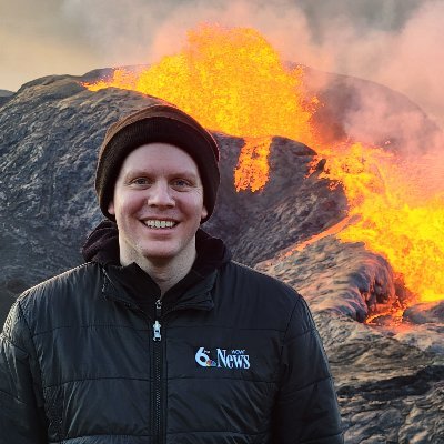
Just unreal! Never thought I would ever be able to get so up close and personal with a volcano. Such an amazing experience. Incredibly powerful and beautiful at the same time. Unforgettable trip to Iceland!

3
2
80
The wind chill in Omaha has dropped to -40° as of 8pm! We see numbers like this in forecast model data on occasion, but rarely does the wind chill fall this low in reality, at least for Omaha. Please be safe if you must spend time outdoors! Limit exposure as much as possible.

1
24
78
Should we update the name of the Omadome to Nebraskadome? Or what would you call it? This map is ridiculous for the middle of winter.

9
6
80
Tonight I'm thinking about my friend and colleague Doug Heady and his son Christian. Doug has been there for me since I started doing weather. His son is fighting hard tonight against cancer, so we're wearing one of his favorite colors to show him that we are with him!


3
2
77
The Big Papillion Creek at Fort St. just hit a new record level, and is currently at Moderate flood stage. Anyone in the area able to see where the water is at?

7
17
80
GOOD NEWS! The severe weather risk has just about completely diminished for the entire area for hte rest of the evening. Therefore the First Alert Weather Day has been cancelled! Some light showers linger this evening, with a more rumbles possible overnight, but nothing severe.

3
7
76


Be glad we were on the "warm" side of this storm system! Just a casual *22.5* inches of snow today in Deadwood, SD ... and it's still snowing! WOW! Who's ready for winter now?

12
17
73
First time I've broken out the ski goggles just to clear some snow... That wind means business!! Be careful if you're attempting to clear snow this evening!

1
4
70
Evacuation preparations are underway in Iceland as the island nation faces the possibility of a new volcanic eruption in the coming days. Thousands of earthquakes and ground uplift signaling the potential eruption... all happening not far from the famous Blue Lagoon.
8
45
71
I'll have to do some checking... but I don't think I've had wind chills this cold in my forecast before. -30 to -40° certainly... but I'm not sure I've forecast wind chills below -40° in the past! Not something we see every year here that's for sure. Stay safe and stay warm!

4
10
69
We did it! No more pre-5pm sunsets until next fall! Not a lot of sun today, but still a milestone. This evening the sun sets at 5:01pm, and sunset only gets later from here on until June.

4
4
70
MISSOURI RIVER FLOOD OUTLOOK: Expect flooding to begin north of Blair on Monday, reaching Omaha early Tuesday, and south of Omaha Tuesday-Wednesday. Moderate flooding is expected with potential impacts to I-680 / I-29 as well as many parks, camping areas, and some infrastructure.


6
20
69
I'll see you in a week Omaha! Don't do anything crazy while I'm gone!
In the meantime
@mschnellWOWT
and
@ClayOstarly
will be keeping you updated in the evenings.

7
2
68
Looking back... It wasn't perfect, but I'm pretty happy with the forecast we had Sunday night into Monday AM. High end totals went a little above what I expected in central Nebraska, and it certainly took a little while to get going in Omaha, but we got there in the end I think!


2
5
66
The river is still rising, but quite the remarkable difference in the level since Noon today. The river now well above normal levels, flooding several of the sidewalks and the parking lot at Tom Hanafan Park. The river will rise several more feet tonight! [Images: Noon, 3pm, 6pm]


2
12
68
Incredible time-lapse video of the thunderstorm firing up just east of downtown. Thanks for sharing Mikayla!

2
9
67
Just sitting on a hillside with a few hundred of my closest friends... Watching a volcano! Spectacular day!


1
1
65
UPDATED FLOOD OUTLOOK - Flood Warnings remain in place beginning Monday for the Missouri River. Moderate flooding is forecast at Blair, Omaha, and Plattsmouth. Impacts to I-29 / I-680 / Hwy 34 are possible, in addition some industrial areas and many parks, camping areas.


3
19
64
Wow... Crazy view of an avalanche on I-70 between Copper Mountain and Frisco. My dad and I were right there last night... Glad we left the mountains last night and not today!

⚠️ 🏔️ Avalanche caught on camera: Snow came crashing down in Colorado near I-70 in Ten Mile Canyon outside Copper Mountain this afternoon. | Hear from the man who saw it all and took this video tonight on FOX31.
195
3K
7K
1
14
61
Incredible show of the aurora tonight, faint reds and greens were visible to the naked eye with streaks of light in the sky. There were flashes and pulses, really cool! A slightly longer exposure on my phone really made the colors pop! Awesome night! Taken near Honey Creek, IA.


1
7
62
TORNADO RATINGS: While damage assessments are ongoing, initial reviews suggest at least EF-3 damage in western Omaha wit the tornado that came up from Lincoln, and at lest EF-2 damage near Eppley and into western Iowa. The review will take days, these numbers will be updated.

5
15
61


Check this out! The top of the Woodman Life building and the towers in Midtown are sticking out of the fog! Almost looks a bit like a lake, the fog rolling through the picture. The fog been thin... as in close to the ground... should help us to get rid of it after sunrise.

2
13
59
6:50pm Update: Our front or wind shift continues to drop south, moving south of Lincoln and Plattsmouth now. The strongest storms will likely be along and south of this front. Thunderstorms ARE still possible in the metro, they may just not be as strong (which is good news!)


7
11
59
These are just a sampling of the rain totals across the area from the deluge we saw last night and early today... a wide swath of 6 to as much as 8 inches falling for parts of Saunders and Sarpy counties! Incredible rainfall amounts! Totals will be different for your backyard.


2
15
60
Both NOAA and Air Force hurricane hunter planes coming back in for another run through the eye of
#Dorian
here shortly. Multiple readings indicating Dorian has reached Category 5. It's a matter of verifying that data now, and waiting for the NHC to make the call.

0
35
55

Rain is moving into the metro! Hopefully it will help with the firefight on this large wildfire just north of Council Bluffs between I-29 and the Missouri River!

2
8
58
Went for a bike ride on this beautiful day, treated to a bit of an airshow by Offutt! Looking good!
6
3
56
I know I'm bouncing between snow and volcanoes this morning... but I don't think I've ever seen anything quite like this on satellite. Check out the shock wave this volcano in Tonga produced when it violently erupted just after 10pm last night our time.
2
2
52
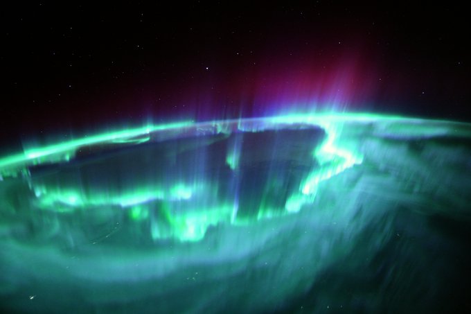
Now that's an amazing picture!
#AuroraBorealis
from the ISS!
#NorthernLights

We were treated to the strongest auroras of the entire mission, over north America and Canada. Amazing spikes higher than our orbit🤩, and we flew right above the centre of the ring, rapid waves and pulses all over.
#MissionAlpha
228
4K
25K
0
7
53
Okay now you're just showing off Omaha.... spectacular sunrise! Still quite frigid but I am expecting a decent warm-up this afternoon. At least a little melting today!

1
3
55
If you're still up, the show is still going! This is from near 72nd and Dodge using night mode on my phone!
#Aurora
#NorthernLights


1
8
54
Incredible video of a tornado crossing I-80 in eastern Iowa this afternoon! Very unusual event for January in Iowa.

Video from Matt Krieger as the tornado crossed over I-80 between the Williamsburg and Amana exits. If you are in a warned area, take shelter now!
@KCRG
12
217
720
1
9
53

This will never get old. Such a spectacular display of nature!


1
2
53
Look at that blue sky! Some bonus sunshine this afternoon for the metro ... I think we've earned it!

0
4
52
In the land of fire and ice, we took the icier path today! Visited Sólheimajökull (sun glacier), Skógafoss (forest waterfall), and Seljalandsfoss. But there are more pictures of fire coming soon!


1
1
51
Check out the fog that's formed in the Missouri River valley! Some ground fog showing up in other spots around town as well. Could see some quick fluctuations in visibility so use caution if you have to be on the road this evening!


4
8
50
Snow and freezing rain move into the area overnight, with a slushy 1 to 2 inches of snow expected by tomorrow morning. Although temperatures will be climbing above freezing, cold ground conditions could lead to icy roads. Additional light snow Thursday.
2
5
52
Some intense moments from Sarpy County this afternoon as flames along with heavy smoke and ash from that brush fire was advancing on Hwy 370 in Papillion thanks to strong south winds. Thank you to Brian and Jen for sharing video with us, glad you are safe!
0
10
50
More pictures of the incredible show of Northern Lights from last night! These from Columbus, NE after 3am!
1
5
51
MISSOURI RIVER UPDATE: New forecast information has river levels rising a little faster on Monday, and climbing slightly higher later in the week. This will likely lead to increased impacts along the river. Moderate Flooding is expected Wednesday and Thursday!


2
12
49
I was honored to be asked to sit on the Eagle Scout Board of Review for Hudson Carrico tonight. It is not an easy task to rise to the rank of Eagle, but from what I saw tonight Hudson is a spectacular example of an Eagle Scout. Congratulations on making the rank of Eagle Hudson!

2
3
50
WOW!
As of about 3:30 p.m., Union Pacific Railroad began transporting evacuees from Waterloo to Elkhorn Middle School via high-rail vehicles using U.P.'s railroad tracks. A variety of resources are available for people & pets from the Nebraska Humane Society & American Red Cross

Unified Command is working with Union Pacific Railroad to use high-rail vehicles to transport Waterloo and Valley evacuees to Elkhorn Middle School.
0
5
17
0
9
48
Total Lunar Eclipse tonight! We have clouds and showers this morning, but skies will be clearing for the metro just in time for the eclipse. If you plan to be out watching it, probably want a jacket as it will be cooling off quickly this evening. Totality starts at 10:29pm.


2
16
49
Mind blowing races tonight! Absolutely incredible to watch. So exciting to see Team USA grow! Also a pic of the
#GOAT
himself Michael Phelps cause I couldn't help myself.
#SwimTrials21


0
1
49
4.3 Magnitude earthquake just northwest of Seattle in the last 30 minutes. Likely not large enough to cause much damage, but big enough to rattle some nerves this evening!

1
11
48
Mostly melting slush so far in the metro, but the snow is piling up quickly just to the west of Omaha! Already 5" on the ground in Columbus and around 3" in Wahoo. The latest report from around Lincoln was just over an inch, but that was a while ago now. Just a waiting game now!

5
10
48
From the
@CityofBellevue
: American Heroes Park and the Haworth Park Campground and Public Boat Docks have been closed to the public as of Noon today.

1
17
48

Totality! Phone isn't doing quite so well, but our TV camera is looking good! Live look at it coming up in just a couple minutes.


2
4
45
Here is our updated snowfall forecast. Key things to remember: Narrow but intense bands of snow are expected. This could create snowfall amounts that change quickly over short distances. Also, freezing drizzle in the morning may create slick conditions for the morning commute.

3
8
45
A strong geomagnetic storm is underway this evening! *IF* conditions persist, auroras may be visible across parts of Nebraska and Iowa tonight! Best viewing is likely after sunset through 1am. You need to be away from city lights, and the view may look dim to the naked eye.


3
11
47
Oh hello there! Enjoying the view? 😂
Bet the breeze feels pretty good up there!

1
1
45
The wildlife was out on my bike ride today! Apparently there is a bald eagle next along the West Papio trail! So cool! Also saw a pack of coyotes. That was also a surprise.


1
6
46
For anyone who saw this clip and was wondering... our camera somehow survived! (As did the tree). Looks like it was a power cut that knocked it off air. Still a very surreal experience watching that tornado come straight at the camera. Damage still very evident at Eppley.

Many unbelievable sights today & devastation from tornadoes across our area. This is just one of those incredible moments... a tornado develops right on top of Eppley Airfield, then makes a beeline for one of our cameras, eventually taking out the power and/or the camera itself!
2
27
134
0
12
47
FIRST ALERT: While we are still a few days out, odds are increasing for an impactful snow Monday. Right now plowable snow seems likely for most. Not sure everyone sees 3" of snow, but odds look good for at least 2-3" of snow around the metro. I'll be tracking this all weekend!


2
5
46
Beautiful! I shared a preview of this yesterday, today we have the full view! Jeremy Shields sent us this photo of the Northern Lights Thursday morning from the Loess Hills east of Little Sioux, IA. He says the aurora was faint to the eye, the picture is a 20-second exposure.

1
8
44