

Chris Fawkes
@_chrisfawkes
Followers
9K
Following
622
Media
522
Statuses
4K
Broadcast Meteorologist. Like all things weather esp severe weather, stratospheric warmings & snow. Love swimming, skiing & occasional triathlon. My views only.
Joined November 2011

2021 has started where 2020 left off, this time mother nature giving me the bird. Just been knocked off my bike at 23mph by a pheasant. I'm afraid it didn't end well for the pheasant or my knee. Helmet stopped me getting a head injury.

44
3
128
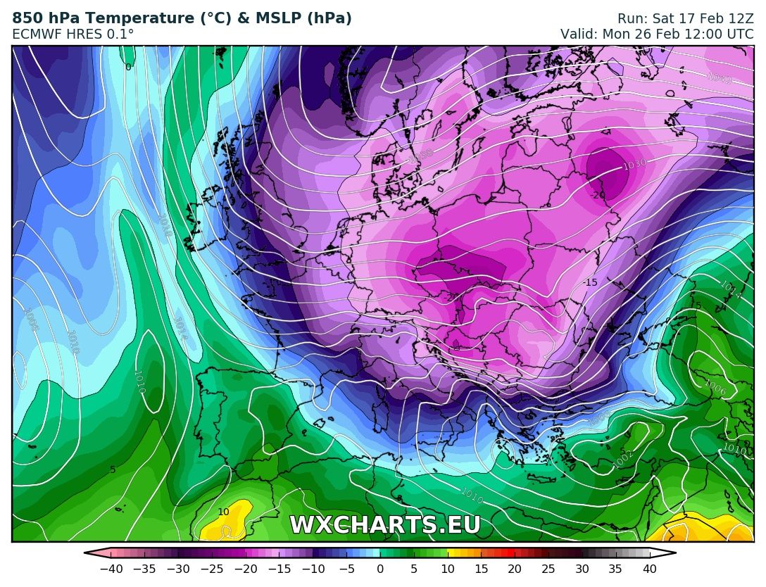
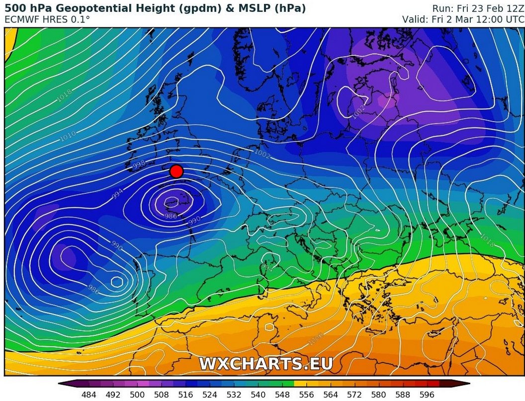
It's official, 12Z ECMWF run is a little beauty for those that like the coldest weather of winter with #snow - 'the beast from the east' taps into reservoir of bitter Siberian air
18
51
132
ECMWF 00z model locking on to the 'beast from the east' as bitter Siberian air empties out over UK 26th February with #snow risk. If this all comes off the cold could last a long time with such a strong Scandinavian high.

10
78
120
It's been snowing literally all day. Is that all I get? Seriously? 🤬 #BeastFromTheEast #snow

19
1
119
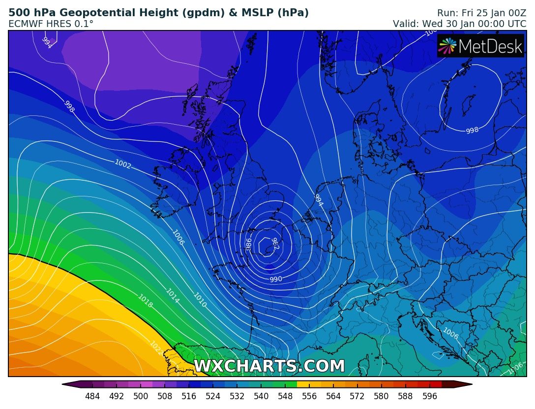
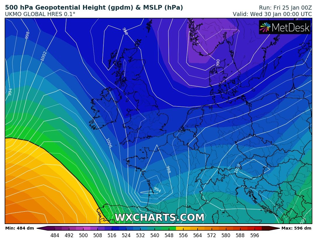
Next week has #snow potential for UK especially Tue 29th/Wed 30th. Latest EC puts snowmageddon into England & Wales, UKMO global less developed and more restrained. Take away message is snow potential is there, details about where and amounts are not!
13
29
119

No changes here, say hello to 'the beast from the east' still on track to arrive Monday 26th February! Models increasingly showing embedded troughs that would bring heavy #snow to East England next week.

13
56
118
Just had first dose of AstraZeneca Covid-19 vaccine and wanted to say THANK YOU to everyone involved in this amazing project.@NHS @OxfordVacGroup @AstraZeneca

8
0
112
Monday 26th February my favoured date for the arrival of 'beast from the east' with #snow risk increasing. Still over a week away, but one to watch!
10
31
109
The 'beast from the east' arrives Monday with bitterly cold weather. #snow initially in east becomes heavier & more widespread then potentially extremely disruptive with blizzard risk towards end of week. Up to 10cm in Met Office current warnings just the start.
16
65
98
Bike ride for my 'daily exercise' today, got a little distracted.

15
2
101
In this strangest of years, never thought I'd get into open water swimming in the UK! Great day for a cheeky lunchtime 3km. #rubber

6
0
100
It's over 3 weeks since I first forecast the 'beast from the east', my personal record for forecasting ahead for UK weather!
Beast from the east to follow sudden stratospheric warming? Wouldn't normally pay much attention to GFS at end of run, but I think this is the type of easterly pattern we may see late February

7
1
90

Well chuffed. Second place at today's @CrondallTri triathlon! 400m swim + 20km bike + 5km run = 61mins. My personal best time!

5
3
89
Following the recent Major sudden stratospheric warming, think we may get high pressure build in Atlantic with cold outbreak beginning around 18th January with some snow. Some uncertainty, but one to watch.

Significant weakening of the stratospheric vortex over the next week. Think this may be involved in helping maintain the cold weather pattern over UK for a big chunk of January
11
15
93
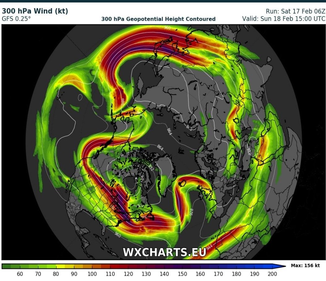
Incredible! The atmosphere runs backwards in March; easterly winds stretch from Russia, over Northern Europe, past UK, across North Atlantic all the way to Canada!

15
48
90
Snow-lovers EC12z has hit the mother lode for Sunday. Widespread disruptive #snow including parts of south, perhaps 10-20cm. Caveate that there is still lots of uncertainty with crucial track of low

15
44
84
Heavy #snow and blizzards signalled Thursday night into Friday. Snow may turn to rain for some, but not before causing big problems. #Blizzard2018

21
39
85
I do like a good thunderstorm, but not so much when I'm camping. Funnel cloud and hail in the last 2hrs. #GiveItARest


5
4
82
In 1953 a North Sea storm surge killed 2551 people. Could history be about to repeat? Track of low in EC looks scarily like 1953s low and we're near Spring Tides. This looks incredibly dangerous to me, please keep up to date with official forecast for this event.

19
43
74
First #swim today in a while, a cheeky 3km. Pools still shut but open water venues with social distancing opening up. Great to be back in the water!

8
1
77
Tuesday could bring widespread #snow to East England. It's too early to be 100% confident but tonight's ECMWF develops a discrete low centre and is similar to some recent GFS runs I've seen. I'll let you know if this signal continues over the next few days.

16
25
70
Check out what I've just found in my garden underneath rotten logs. Think it's a smooth newt (protected), anyone know for sure?


14
2
72
This chart is a spaghetti chart, it shows uncertainty, the more it looks like spaghetti the more uncertain the forecast. I won't be talking about #snow amounts next week just yet, it would be a load of Bolognese!

7
7
73
The risk of heavy #snow end of the week is still there, but it's very complicated! Travel disruption Thurs & Fri evenings looks likely. Amounts very uncertain, but as a stab 10-20cm widely. High ground Wales 30cm+ and south and east Ireland gets clobbered. Blizzards for some


24
35
61
Big storm next week for northwest Europe with severe gales & dangerous North Sea storm surge to bring coastal flooding. Keep across warnings for this system.


6
32
65
An extreme #heatwave builds next week, with the UK temperature record under threat next weekend

19
18
61
This amazing NASA satellite shows extent of #snow in southern England & how close it came to getting Heathrow!

5
17
59
A rare hole in the #ozone layer has formed above the arctic and is set to drift towards the UK this weekend.


16
33
63
Beast from the east to follow sudden stratospheric warming? Wouldn't normally pay much attention to GFS at end of run, but I think this is the type of easterly pattern we may see late February
9
14
58
Significant weakening of the stratospheric vortex over the next week. Think this may be involved in helping maintain the cold weather pattern over UK for a big chunk of January
7
9
59
The Atlantic #jetstream begins to buckle this weekend setting up a blocking weather pattern, this opens the door to the 'beast from the east' with potential for cold & snow late February to early March. All this follows major Sudden Stratospheric Warming #SSW
6
45
59


Anomalies from the Sudden Stratospheric Warming are moving from the stratosphere to the troposphere making cold weather much more likely from next week and into February.

2
20
58
A Sudden Stratospheric Warming is on the way resulting in split #PolarVortex - cold polar air sloshes out to Mid-latitudes later this month
15
24
59
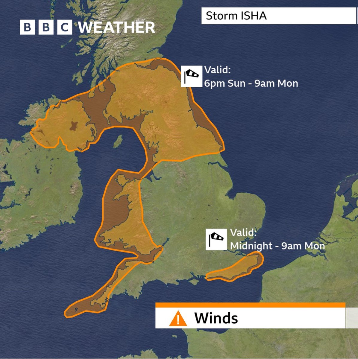
Amber warnings out for storm Isha Sunday evening to Monday morning; Gusts up to 80mph. Some trees will get blown over with travel disruption & power cuts likely.
6
13
59
Racing for Hampshire today at the Olympic pool. First time racing in here - what an impressive building!

7
1
60
There's a round of heavier #snow forecast for Thursday night parts of South England, East Anglia, Midlands & Wales. 5 to 10cm generally but more for Welsh hills, over 15cm looks possible.

7
19
56
Very difficult forecast tomorrow detailing rain or #snow. Some models have East Anglia and southeast England with 5-10cm snow, others have no snow, only rain! If the trend's your friend, you might go for snow.


6
8
58

Bingo! Metoffice reports UK winter was colder & sunnier than average, my 5th November guess called it right! Winter was -0.2C below 81-2010 average, doesn't sound much but in our warming world this was coldest for 5 years!
My guess for UK winter is colder and sunnier than average, with some decent snow - fingers crossed!
7
6
55
Well there's something you don't see every day! Category 2 hurricane #Ophelia passing Portugal & Spain. Credit Eumetsat

2
36
59
Snow fans; EC12Z shows Midlands & Wales hit hard by Sunday #snow 20cm+. Then Monday Midlands & south England gets carpeted with heavy snow, another 20cm. Bring it on!.
30
21
56
The #heatwave continues. A few thunderstorms in the week ahead, but I can't see widespread rain for the first half of July.

4
11
53
Remarkably at this time scale, the low that brings heavy #snow risk to UK Friday already exists! It's just leaving US east coast and will do a slow lap around the Atlantic before moving towards UK from southwest and snacking into the bitter Siberian air. #blizzard2018

13
18
52
Nice of the #RedArrows to display over my garden while I'm self-isolating due to positive #COVID19 contact (2 jabs & 2 negative PCRs says I haven't got it)

7
0
55
Finished racing, came respectable 7th in both 50m & 100m free at the Swimming Masters Nationals 🏊🏻♂️.
5
3
52
Potential for disruptive UK #snow towards end of next week. Not 100% nailed on, but I have seen a number of similar looking model runs over last few days! One to watch.

2
26
56
First swim race for 5 years after surgery for nasty shoulder injury. Won Hampshire county masters for my age for 50m & 100m free. 25 seconds for the two length race. Great to be able to race again, it's been a long wait!.
10
3
52
Very strong winds heading our way Sunday / Sunday night with gusts to 70mph. This system may get named, keep across forecasts.
4
15
52
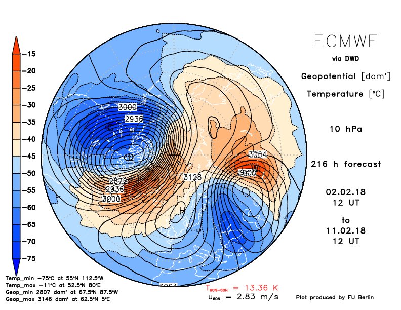
A pretty spectacular 60C rise in temperatures over the North Pole as a result of the Major Sudden Stratospheric Warming! #ToastedStratosphericVortex

7
19
50
By end of friday expect Central Southern England, SW Eng, Wales, W Mids to get 10-20cm locally 30cm. Exmoor, Dartmoor & Brecon Beacons could get half metre dump! #blizard2018

15
33
48
#StormEllen seems to be developing sting jet feature. Destructive gusts for Ireland, especially Cork to Waterford tonight. Gusts could hit 90mph, with trees in leaf, looks very damaging.

4
7
54
The north side of low brings 10 to 25cm of #snow. This currently heading to north France Tuesday night with disruption. If low were to track 100miles further north (not a huge error at day 3), then we'd be more in firing line. That's why it's important to keep checking updates

9
11
48
No prizes for spotting the Sudden Stratospheric Warming; an incredible 40C+ temperature rise toasts the polar vortex!

6
16
53
Heavy #snow heading to east England this weekend, 10-15cm possible parts of East Anglia. Next week looks interesting for systems coming into south of UK with snow.
5
11
52

Disruptive snow next week for some, northern areas of UK at greatest risk. As a #snow lover, I'd love to get a low pressure towards the end of next week like in this model (10-15cm widely Eng & Wales). Although possible it's very likely to change this far ahead, but I can dream!
5
3
50
Some hefty #snow bands for eastern England & Scotland next couple of days. Snow accumulations varying from place to place, but some disruption expected.
6
5
49
The majority of models (Inc EC12Z) are not analysing the weather well over France & Iberia in my opinion. Hirlam seems about the best fit I can see. This could mean we get an earlier #blizzard2018 onset & threatening areas further east too for Thursday morning.


23
19
43
Snow disruption is possible for parts of Wales, Midlands, East Anglia, Southern England from Tuesday night to Thursday - but it's too early to know for sure. Track of low could take the #snow into north France instead.


4
3
51

Big thunderstorm just southeast of Oxford. Rain looks torrential on radar.

11
3
44
#snow will continue to get heavier and more widespread this week as the air gets colder and increasingly unstable. Convection will increase from the bitter air moving over the 'warm' North Sea making increasingly heavy snow showers


6
25
48
Cold air returns to bring some #snow to East England this weekend. Main model differences regard northern extent & timing but southeast in firing line.


6
22
44
Bitter cold air pours off Scandinavia, heated strongly by the North Sea to create widespread #snow showers in this beautiful NASA satellite picture. Snow showers in Lincs & Yorkshire started growing in Finland!

6
21
45
Quite like 12Z Arpege. It shows a widespread band of #snow arriving early Friday morning in southern England, including London, well ahead of many forecasts. Models continue to struggle with fine details #beastfromtheast

11
7
46
Costa del snow! Incredibly rare #snow on the beaches near Valencia Spain. I'm told this hasn't happened for decades!


3
33
49
Beautiful NASA satellite of extensive #Uksnow including yesterday's dump across Wales, Midlands & Central Southern England

8
8
47
Polar low hits east England early Tuesday bringing heavy #snow with first round of significant disruption for Yorkshire, Lincolnshire, E Mids. Trough extending north takes the heavy snow across NE England & E Scotland too.

10
20
44
Some #snow still looks likely Tue 29th/Wed 30th from low to south of UK but also from troughs coming from northwest. Snow amounts sensitive to low track (could change a bit) therefore balance between rain & snow. Some disruption possible

4
11
44
#StormÈowyn on its final approach to the Republic of Ireland with a potential stingjet starting to form . Could be unprecedented windstorm. Gusts on the west coast to reach about 120mph, the current record is 113mph set in 1945 & equalled in 1961. Severe damage expected
7
14
48
UK #Snow? Mon 21st/Tue 22nd have potential but a build of pressure in west Atlantic is crucial as it would steer lows across southern UK. Without this build of pressure they'd track across north Scotland and it would be relatively mild. Still 10 days away but worth watching.

3
14
43
Next week UK #snow? EC puts half a metre of snow into the north by next Thursday, but more important is how sensitive the models are to very small changes in the jet stream therefore development & track of lows. It looks colder next week, but no details are clear yet!

7
6
44
It's not much, but it's a start. Snow coming down in my village tonight

4
3
41
Are we getting cold weather next week? J Furtado et al showed that when we have the conditions we have now; a weak stratospheric vortex (following SSW) combined with phase 7/8 Madden Julian Oscillation we get temperature pattern that looks spookily like EC forecast next week 👇


5
5
44
Incredible video of Czech #tornado that devastated Hodonin yesterday. Unbelievable winds from about 3'15 onwards.
3
10
42
I've just heard Hampshire won the overall Swim England Masters Inter-Counties title 🏆 Here's a little vid of me swimming the last leg of the 200m Freestyle relay for Hampshire.
6
1
41
Flight from L.A. to London reaches 801mph thanks to record-breaking #jetstream - Los Angeles Times
3
11
40
Really interesting watching Major Sudden Stratospheric Warming unfold. GFS continues to stop anomalies from reaching troposphere with resemblance of a non-downward propagating SSW as in Karpechko. But @judah47 identifies lack of downward propagation as a known model error.

13
6
38
I would argue next week's cold & #snow potential is related to sudden stratospheric warming that started December. There's a subtle shift in the jetstream south taking low pressure track south too at the same time Arctic oscillation goes negative! Chart

5
5
39
#snow has already arrived widely in southern England well ahead & further east from majority of forecasts. Arpege looks good, disruptive snow for #London this morning, winds strengthening later as snow moves north & west. #blizzard2018


11
24
38
Sudden stratospheric warming; both EC & GFS are doing the splits! Still differences in timing and position of resultant vortices.


6
6
39
#beastfromtheeast2 ? Comparing the two; The original beast in 2018 had much colder air (greater depth too) so large falls of disruptive snow were more widespread. This time around winds are stronger so East Anglia & Kent at greater risk of blizzards and #snow drifts.


6
6
39

Right, first today's dodgy snowman then thoughts about Monday's weather.

1
3
41
Just back from holiday - I wasn't completely sure I correctly obeyed this road sign!

3
1
42
With the Atlantic nicely blocked, December is likely to be much colder than normal for UK, might get some #snow next week too.

4
15
42
The stratospheric vortex takes a battering late December, could bring about a major Sudden Stratospheric Warming - one to watch! #SSW

9
16
36
Snow down to sea-level in Volos, Greece.


2
9
40