

Todd Klaassen
@ToddKlaassen
Followers
4K
Following
5K
Statuses
12K
Certified Broadcast Meteorologist(CBM) for the Morning and Noon newscasts on WRTV. The ABC station in Indianapolis. Also can be heard on various radio stations.
Indianapolis, IN
Joined June 2009
No typos here. Warmest day of the year on tap as we climb in to the 60s in most locations. It will be a bit windy and skies will be mostly cloudy but still can't complain about 60s in February. Enjoy today because colder temperatures do return. @WRTV

0
0
1

Tonight's sunset is at 6 pm as our daylight hours get longer and longer. In fact, we are now adding over 2 minutes of daylight per day and we won't have a sunset before 6pm again until the time change in early November. @WRTV

0
0
3
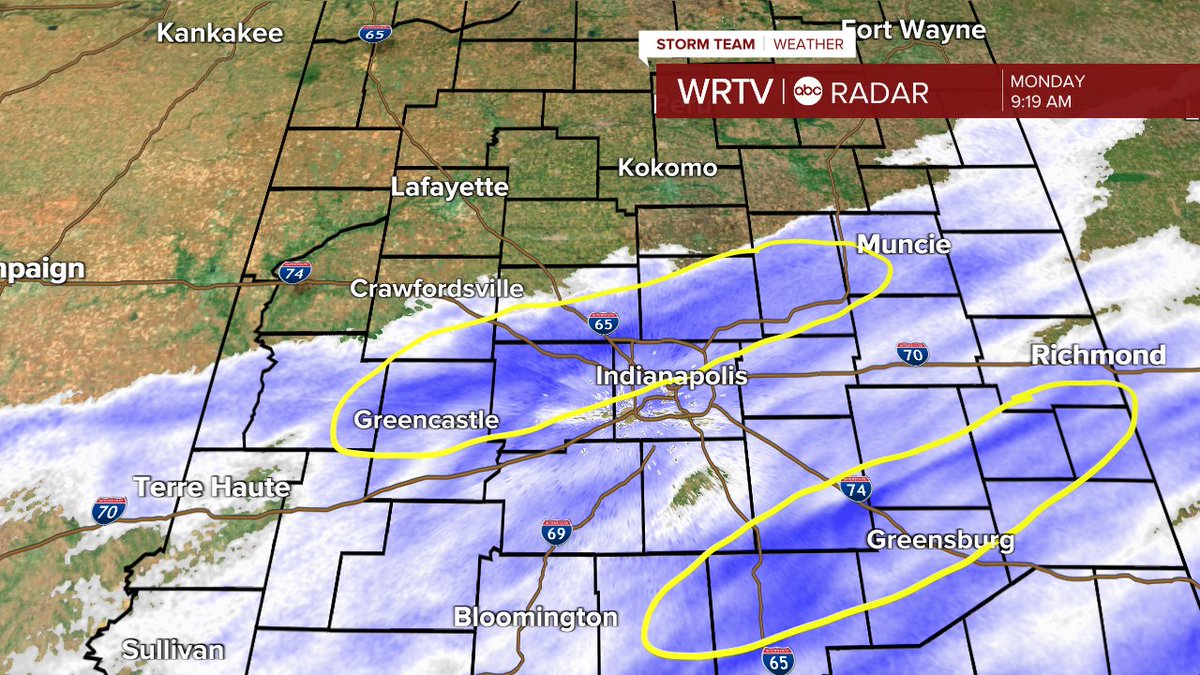
Don't be shocked to see a few snow showers this morning into early afternoon. Quick coating is possible in spots but otherwise shouldn't be too much of an issue. The snow showers are along a front that will drop the temperatures this afternoon. @WRTV

0
0
0
Bitter cold morning as many of you are waking to temperatures below zero this morning. Bundle up. Even with plenty of sunshine all day our high will only be in the upper teens. @WRTV

0
0
1
Bitter cold today so make sure you bundle up. Temperatures will start in the single digits and only climb into the low 20s this afternoon. A Winter Weather Advisory starts at 4am tomorrow for more accumulating snow. @WRTV

0
0
8
RT @Seatonturf: Impressive snow totals in Broad Ripple! It finally stopped. 9.5” @ToddKlaassen


0
1
0
Two good bands of snow on radar still. Also, you can see where the snow to the north has ended. Although blowing and drifting will still take place. Most areas where it is still snow will see an inch or less of accumulation. @WRTV
0
3
8
Here is a look around 8am in the New Castle area on I-70. You can see the snow sticking a bit to the roads east of Indy so use caution. @WRTV

1
2
2
Snow showers are approaching the state line in Illinois and will spread across our area this afternoon and early evening. Watch for slick spot, low visibility (off & on) and followed by bitter cold temps tomorrow morning. Wind chills will be below zero in spots. @WRTV

0
0
0
DENSE FOG ADVISORY now in place for most of the area until 10am. Give yourself extra time on the roads and also check for school delays. All the delays can be found on the @WRTV app.

0
2
4
Dense Fog this morning. Extra time will be needed on the roads. Many school delays coming in as well to WRTV.

0
0
0
For those of you looking for warmer temperatures this weekend is for you. Tomorrow we jump into the low 40s and then the low 50s on Sunday. Clouds will increase Sunday and it will be a bit windy but we stay dry until late in the evening. @WRTV

0
2
1
Bitter but beautiful this morning. Bundle up as you walk out the door with temperatures in the teens and wind chills in single digits. Plenty of sunshine today with highs around 32° @WRTV

0
2
0
Snow showers are approaching the state line. Look for some to sneak into western locations as they slide to the southeast. With the cold ground there could be a coating southwest of Indy. @WRTV

0
0
0
8 AM temperatures are bitter cold this morning. Single digits and teens in all locations so make sure you bundle up. We only climb into the the mid 20s for afternoon highs. @WRTV

0
1
0
Snowflakes starting to fall in Bloomington. Could see an inch of snow for the Bucket Game.
0
0
0
Mild temperatures continue today but with rain showers developing. Look for light scattered showers to move through this afternoon. They should be done by about 8pm. Colder through the remainder of the week. @WRTV

0
1
0

A quick band of rain will move through the area this morning and then we quickly get back into the sunshine this afternoon. Have the rain gear through handy before the noon hour though if you are going to be out and about.

0
1
3