

Andrew Moore
@OSUWXGUY
Followers
2,563
Following
2,355
Media
4,725
Statuses
9,068
Work at the intersection of weather and reinsurance risk for Arch Reinsurance. Love to golf/ski/surf. Views expressed are mine alone. @osuwxguy .bsky.social
Bermuda
Joined May 2009
Don't wanna be here?
Send us removal request.
Explore trending content on Musk Viewer
#DNC2024
• 168441 Tweets
River
• 145298 Tweets
Macri
• 89559 Tweets
Bill Clinton
• 84986 Tweets
Simón
• 79175 Tweets
#虎に翼
• 56039 Tweets
Okan
• 44881 Tweets
Mike Lindell
• 39555 Tweets
Talleres
• 25798 Tweets
サンサン
• 25228 Tweets
JENNA
• 24677 Tweets
#AEWDynamite
• 22521 Tweets
Soto
• 22116 Tweets
Oprah
• 21028 Tweets
Borja
• 18482 Tweets
Peñarol
• 16877 Tweets
Stevie Wonder
• 14902 Tweets
Geoff Duncan
• 14229 Tweets
Joey Votto
• 12205 Tweets


Eyewall convection already starting to perk up as Fiona's center moves back over water. I'd imagine a significant period of intensification to begin in ~ 6-12 hours. How strong does it get? Guidance certainly suggests a cat 4 is possible

14
50
294
Cyclone Mocha going absolute beast mode as forecast ☹️ with round eye surrounded by -80 to -90C cloud tops and round CDO
3
45
243
Incredible sun glint looking almost like a zipper as it reflects off the very smooth ocean over the eastern Atlantic - notable for the weak trade winds (smooth ocean) and for the lack of Saharan dust --> both favor continued anomalous warming, yikes!
6
35
180
My favorite phase of TC forecasting is watching a disorganized group of clouds slowly become better organized until it eventually becomes a tropical depression - eg 92L currently
5
14
156
Not often you see +3°C anomalies near 10°N in off Africa, this is one quite remarkable chart

8
15
144
GFS about to face plant on the biggest of stages in the 2022 hurricane season
21
14
123

These negative anomalies, especially surrounding Florida into the Bahamas are living on borrowed time - strongest sun of the year + lots of clear skies + weak winds = rapid warming over the next 10 day

8
19
121
Looks like the engine just roared to life with Idalia. -80C convection arcing around the LLC inside the RMW. Good chance we have a hurricane by tomorrow morning
6
15
118
PTC4 appears to forming a surface center near 20.3N 78.3W with westerlies evident in the low level clouds near Cayman Brac. More southerly starting point and slightly less time over Cuba should help lead to a stronger system than the current forecast and possibly a bit further W
6
20
116
Folks in the Lesser/Greater Antilles should keep an eye on the wave near 30W. Solid support across the global model control / ensembles for development. Will do a detailed thread late this afternoon but you can see in the EPS below that a stronger system earlier goes more North

4
27
108
EPS starting to perk up a bit on possible MDR development as we head toward August, which makes sense in the context of the broader forecast pattern, though late July/early August is still a a bit early climatologically for prime peak season conditions

4
16
106

Why are Atlantic MDR SST so warm? Pretty explanatory image showing low level winds for the past month vs climatology (normal) - the past month has much weaker trade winds (less reds/yellows) across much of the tropics - especially noticeable near NW Africa
5
15
100
Sweltering heat looks to continue across Mexico with the ECMWF ensemble mean showing mid level height anomalies as high as 4.7 STD DEV above the climate of just the past 20 years. Suggests a probability of ~1 in 769K

8
28
101
I'm still scratching my head a bit on why I caught so much grief yesterday for saying that a wave that will largely have favorable shear conditions and has decent vorticity and a fairly large moisture pocket was worth watching 🤷♂️
10
11
96
Pretty fascinating to have a strong Cat 2 with a well defined eye in such close proximity to a powerful cold front - baroclinic impacts starting to show in the convection to the N and NE as the warm, moist air is lifted up over over the cooler, more stable air north of the front

4
11
97
Still a LONG way to go, but this would be another well timed trough for the East Coast

11
3
96
W Caribbean low with a roaring El Niño enhanced subtropical jet won’t be boring 👀

5
7
95
Striking difference, especially for the Caribbean, between last year's February ECMWF forecast for June/July/August and this year's forecast
Probably a good sign that the Caribbean won't be as quiet as last year...
6
24
94

We are not any closer to knowing if Ian will landfall near Tampa, but it is interesting to note that the last cat 1 hurricane to landfall in the red box was in 1946, the last cat 2 in 1944 and the last (and only) cat 3 in 1921

6
23
92
Can see the mesovortices within the eye, as well as the firehose of moisture aimed at the southern portions of Puerto Rico and undoubtedly being enhanced by the E-W oriented mountains to 3000 ft + Ugly look, thoughts are with all being impacted!

4
11
89
I think it’s fair to say they share at least some of the passion for watching the Hurricane Earl swell as their father 🌊 🌀 👀 ❤️

5
1
88
When folks talk about the "Spring Predictability Barrier" in regards to predicting the El Nino - Southern Oscillation, here is a perfect example of the challenge. March Nino 3.4 anomaly (dashed blue line) was outside the ECMWF SEAS5 forecast plume from December

5
11
84
Latest ECMWF seasonal modeling is aggressive with its Atlantic hurricane season forecast through October as expected - its activity forecast is the highest of any season since 1992 (blue line) and is in the company of the 1995 / 2005 / 2017 seasons actual ACE (red dotted line)

7
25
83

TS Cindy is a gorgeous little storm this morning with a fairly axisymmetric CDO and outflow. Probably a bit of dry air being pulled in with the notch in the NE, but low shear should allow for some intensification over the next 24 to 36 hours
1
7
81
The MJO has moved into the Atlantic and will help enhance the West African Monsoon over the next 2 weeks


1
11
80
Trend is our friend with 91L! Northward trend makes it less likely to threaten the Bahamas and the US East Coast. Still don’t have a storm center so plenty of uncertainty so could trend the other way

7
13
81
Almost looks like the western disturbance in the monsoon trough in the Western Atlantic is trying to close off a circulation just south of 10N 35W
7
5
80
We'll have had anomalous rising motion (green -VP anomalies) focused over W Caribbean/E Pacific for over half of June and very warm SSTs and still it looks like it'll be a struggle to even get one tropical cyclone out of the pattern
13
8
74
The Yucatan Peninsula and the upper level low (red area over the western Gulf) very likely saved the US from a major hurricane landfall. The track Beryl is currently following would have been quite bad for Houston, if the environment had been moister and Beryl's core more intact

9
8
77
I posted a similar pair of images last year emphasizing the uncertainty associated with forecasting ENSO beyond the NHEM Spring. Left image shows the ensemble forecast from Jan2022 in red lines, while the dotted line is actual - right is the new Jan2023 forecast


9
18
70
A thread of random thoughts on Tropical Storm Fiona - Recon is finding that the storm continues to slowly deepen - down form 995mb to 992mb - despite fairly limited deep convection

2
8
71
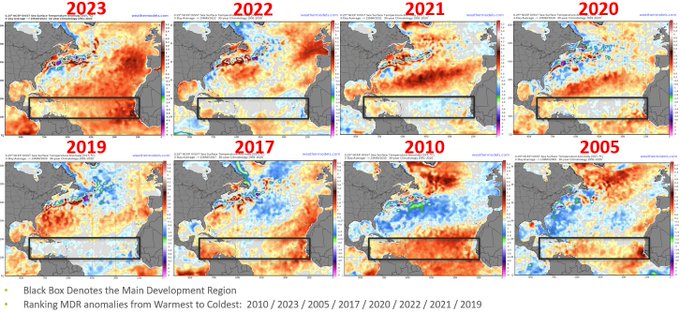
As we edge closer to the peak of the Atlantic Hurricane Season, where do we sit in respect to SST anomalies compared to recent years? We are well cooler in the MDR than the hyperactive seasons - 2005/2017/2020

6
18
72
First light video, too windy to be on the ocean side outside. Pretty gusty now
5
6
71
Convection has consolidated and consistently fired over top the central portion of the wave axis, kinda curious if it hasn't spun up something under those clouds at this point. Certainly looks worth dubbing it an invest IMO
1
6
70
Mid-level ridging trending stronger to the west of Lee in the GFS, slowing it down
6
8
67
Hi
#BermudaHigh
,
I know El Niño really sent you into hiding, but we are excited to see you more in 2024!
-Bermuda Sun Lovers

9
9
71
92L certainly appears to be trying to build a LLC+core, but will need to wait for visible satellite or a wind retrieval to be sure. Let's see what the morning brings!
0
8
66


Hot off the presses - June ECMWF seasonal modeling continues to show double the Atlantic tropical cyclone activity (ACE) as the rather active climatology from 1993-2023 - 2.0 in the green bar. 10% below normal in the E Pacific and 30% below normal in the W Pacific

2
15
67
Historical storms from 2010-2021 passing near the northern Lesser Antilles to Puerto Rico left vs 12Z EPS guidance right. Long way to go to see where this goes and how strong it may get!


4
6
65
Quiet early May across the eastern Atlantic with a southerly suppressed Intertropical Convergence Zone (ITCZ) driven by a combination of an Atlantic Nino (equatorial warmth) and the suppressed phase of the MJO passing over.

5
9
66
Interesting feature in the W Caribbean which isn't quite where the NHC places it

2
4
64
Arc of vortical hot towers evident around the south side of Fiona's center. My forecast would be this this to be a hurricane within the next 24 hours, and I do think that storm will track over or very near the SW portion of Puerto Rico on Sunday

6
7
64
Background surface pressures in the Atlantic MDR generally over a standard deviation above normal is not a great pattern for waves to develop - high pressure -> subsidence/dry mid levels

6
7
67
Tiny eye starting to peak out on infrared with Hurricane Agatha after some recent very powerful vortical hot towers rotated around. Glad they have a recon flight headed that way soon!

1
8
62
-80C cloud tops in the eastern Atlantic?!? I thought this was still 2022

3
2
62
Low amplitude tropical wave between 50-55°W with expansive Saharan Air Layer to its N. Climatologically brisk trade winds in the E Caribbean -> high shear for the wave. Slight chance for development w/ potentially more favorable conditions as it get further W late week
2
8
64
Heartbreaking textbook stadium effect with Hurricane Beryl as it tracks over the Grenadines between Granada and St. Vincent 😢

1
5
63
Latest C3S seasonal modeling is out with the mean precipitation anomalies across all models for Aug-Oct shown below - wet West Africa into the Central Atlantic suggesting that peak season ought to be fairly favorable for easterly waves and possible quick development over water

4
12
63
Interestingly though, the latest EC shows fairly limited impact of the upper level trough as Bret enters the E Caribbean storm graveyard, though of course the enhanced trades still means a struggle with shear
2
8
62
Rather odd evolution in the 06Z ECMWF which holds Fiona steady state over the Dominican Republic and then rather quickly strengthens even as half the circulation is still over land 🤔
6
5
61
94L making progress towards getting upgraded this morning, with some convective banding starting to appear around a nascent low level center. Fairly far south at the moment, should gain latitude as it strengthens, but I suspect the NE Caribbean will likely get clipped

4
5
61
#Waterspout
off the south shore of Southampton
#Bermuda
this afternoon. Lasted 5-6 minutes before dissipating as it ran ashore near the Fairmont’s Ocean Club
8
12
61
Latest 45 Day modeling from ECMWF takes us into the start of Atlantic hurricane season!
Clear signals in the precip anomalies for:
+IOD
+Atlantic Nino
Low precip driven by cooling in the equatorial E Pac as we-> likely La Nina by peak season
US looks dry out West + Southeast

7
13
60
12Z GFS getting more bullish with the wave approaching the Lesser Antilles in a couple days
9
6
58
HWRF showing the first Atlantic Basin hurricane of 2022 arriving September 3rd around 12Z
#ZeroAugustHurricanesFTW

8
6
60
July ECWMF Seasonal Modeling hot off the presses, their Atlantic Basin ACE forecast is for 40% above the recent era normal down from 100% above in June
🧵as I dig into it:


4
3
57
Whelp, this part of the argument for a more quiet Atlantic hurricane season has reversed of late...

5
2
56
Interesting to see the EC seasonal showing Atlantic ACE 10% above the 1993-2022 climatology, somewhat surprising given the same model ENSO plume is unanimously into the moderate to strong el nino by peak season


13
10
56
Quite a bit of vortex tilt with 91L this afternoon as SE/ESE trade winds at the surface are cross by upper level SW winds - blue L denotes approximate surface low and red L denotes approximate mid level center

4
12
56
Lee's multi-model ensemble track density plot has shifted west a bit and has tightened a bit. Devil is still in the details though of the exact track and associated impacts
1
16
57
Tons of dry air wrapping into Ian fortunately, with no convection near the center (which is becoming a bit less well defined) It would sure seem that any intensification from here before landfall in South Carolina would be due to baroclinic processes

5
2
57
This cut off upper level low with the stout ridging over Eastern Canada doesn’t bode well for this run

9
3
55
From April 1 - June 5 here are the 500mb geopotential height anomalies for 2020 / 2021 / 2022 with quite anomalous lower heights dominating the NW United States in 2022 in a marked difference from the past two years


2
5
54
Another powerful easterly wind burst forecast by the EC ensemble near the Date Line in the Pacific -> will further reinforce the La Nina and continue to help support the forecast for another La Nina for Northern Hemisphere winter

4
15
56
00Z EPS continues the consistent narrative for a hurricane, likely to stay to the north of the islands, possibly affect the Turks & Caicos, and likely recurve possibly near Bermuda. Overall for a long track MDR hurricane, this would be a great outcome!

9
3
55
Invest 92L has a pretty good shot of getting upgraded sometime tonight or early tomorrow!
SE flow in the low/mid levels has induced some shear overnight and this morning, but this should lessen over the next 12 hours + 92L will be crossing the Gulf Stream near Diurnal Max


1
15
54
A while back, I had posted about Franklin busting through the trough and potentially taking advantage of duel outflow channels to become a major hurricane. Whelp, here we are...

4
3
55
Two of the cleanest African Easterly Waves we have seen this year over the eastern Atlantic - checks calendar, in the second week of October?!?!
3
5
54
It's a good thing that the wave east of the Lesser Antilles has struggled with mid-level dry air or we would have likely had a TC able to take advantage of the entire length of the Caribbean in low shear... Still worth keeping an eye on for now though.

7
4
55
So apologies in advance, but I'm going to be tweeting quite a bit about
#Paulette
the next several days since it's headed my way. Some convection wrapping upshear (toward the SW) on the latest infrared may be an indication that the shear is starting to relax just a bit
1
8
55
@BigJoeBastardi
Hi Joe. Not sure I follow? I was pointing out how warm the Atlantic Basin in as it relates to the upcoming hurricane season. Recent cold in Morocco doesn't seem to change the point that we are the second warmest in the MDR as of mid May
8
11
52
As if predicting the monsoon trough wasn't difficult enough, signal for some E Pac energy to crossover or a CAG type genesis pathway for the Western Caribbean/Gulf in a week to 10 days continues to pop up in the op runs and ensembles. 👎


7
1
54
It's been interesting to watch the models showing some modest signs of interest in the tropical waves crossing the MDR despite the some large scale subsidence being favored (left) over the next 5 days - the 6-10 / 11-15 day forecast looks more favorable


4
10
53
Looking to the eastern Atlantic for what might be next tropically, Invest 95L is being strongly sheared and will be absorbed into Earl and thus is unlikely to develop. The other wave circled is on the edge of a very dry, stable airmass which will make any development difficult

4
5
53
Latest ECMWF seasonal forecast calling for Atlantic ACE 50% above the 1993-2021 climatology, so either the basin will pick itself up off the mat, or many of these seasonal forecasts will bust low

7
4
52
Some good weather news to share, we have moderate rain falling over the Dixie and Caldor fires in California!!!
1
8
51
Progressive CCKW pattern with another likely to be generated in the Bay of Bengal and then progress across the Pacific and could give us another chance for a Central American Gyre and tropical cyclone genesis in the W Caribbean or E Pacific around June 1st

2
7
50
As we begin November, global SST anomalies compared to same time last year show a similar La Nina pattern in the E Pac, but are much cooler this year in the N and NE Pacific including along the West Coast of the US. Atlantic SSTs are warmer near Europe and near the Equator


3
11
51
In a very weak steering environment, the center of Franklin is chasing the deep convection being sheared to its southeast. Quite a rare heading for late August!
1
5
50
GFS has 93L plowing through a fairly strong upper level trough then finds lower shear under the trough axis and intensifies quickly into a hurricane over fairly cool waters near Bermuda
#ColorMeSkeptical
1
12
49
GFS trying to bring a hurricane just off Portugal. Yeah, ok....
6
4
50
Powerful atmospheric river aimed at southern Florida bringing a substantial flood risk over the next couple days as deep tropical moisture floods north ahead of the E US trough - ironically to an area that has been extremely dry and is suffering drought conditions
5
19
50
Going to play guess that final modeled pressure for the low in the Gulf shown in the latest frame available. I'm going to guess 963mb. Hopefully just a spurious W Caribbean convective spinup, but that's a not so fun environment it would find...

3
2
48

Recon is heading for an intensifying Fiona. Looking forward to seeing dropping pressure and increasing winds with each pass, and maybe we get support for an upgrade to a cat 3 before it departs?


3
4
50
Almost comical how the Main Development Region is just about the only region of near to below normal SSTs in the North Atlantic
(PLEASE note that we are a long way from HU season, and these temps can change a LOT even in just a couple weeks, so don't read too much into it)

3
6
50
Always love the setting sun, stadium effect with sunlight highlighting the east stands....

0
5
49
Somewhat interesting attempt at bit of a reversal in the ++AMO over the past 15 days with the MDR cooler (albeit from record levels) and the subtropics warming

6
7
43