
Abyssinian Carto
@MidoCollins
Followers
2K
Following
6K
Media
233
Statuses
8K
Code, Stats, Maps, Data, Cities & 2D
Nairobi, Kenya
Joined August 2012
The last serious updates to National (and Nairobi) basemaps by SoK were done 22 years ago, including this flight diagram of the capital, -2003. A CSP for NAIROBI will require dense data updates. -Zoning 2006 -NIUPLAN 2014 -Valuation ...finance only the national govt can spend.
2
10
41
This is a flaw in PLUPA 2019. High impact land users like this should be accompanied with traffic assessments and management plans that specify the impact and remedies of such developments around the neighbourhood. .

Talanta Stadium to better host the Afcon 2027 traffic management, consider; 1. Additional road from Southern Bypass at outer edge of forest to Ngong road. 2. Extend Kinyajui road to Ngong road 3. Revamp existing railway line & railway terminal station at stadium Thinking aloud
2
6
17
Time-lapse imagery from May-July 2025 reveals an onset of tree harvesting in Karura Forest. This is the last clear Sentinel-2 image before fog blanketed the tropics starting in August. Cadaster (yellow) is layered on imagery. 🌳📸 #KaruraForest
0
7
11
This 1962 topographic map of the Kitengela Game Controlled Area shows PERMANENT rivers, indicating a period of abundant hydrological resources in the region. Modern maps of the same area reflect perennial rivers, highlighting significant changes in water availability over time.
6
65
124
The're no great Cities on the red sea! despite this being a strategic location for trade and maritime routes linking Europe, Africa and Asia.
1
1
4
The sheer scale of resources poured into R&D for proprietary software never ceases to amaze! The innovation driving tools like Esri's ArcGIS Pro is nothing short of remarkable! Link to the book and resources: https://t.co/oQsiWpTfpQ
0
1
6
The're no great Cities on the red sea! despite this being a strategic location for trade and maritime routes linking Europe, Africa and Asia.
3
2
10

This picture is my philosophy. Keep the city in the city. Keep the country in the country.
83
209
3K

CAD should be free and easy to learn. Solidworks costs 2000+ per user per year and NX Siemens costs 10,000+ user per year (industry standard tools). It’s embarrassing how paywalled CAD is compared to coding.
428
241
4K
There used to be an African cemetery right where the MonteZuma Funeral Home is! Illuminatism everywhere.
2
5
17
Last week, the Environment and Land Court issued conservatory orders against City Hall for breaching land-use planning regulations, impacting hundreds of development permissions issued since 2019. Parklands, with up to 1,200 parcels (Zone 3D), is at the center of the dispute.
3
46
73
Under maintenance for a while but I am done with the codework. Be sure to check out https://t.co/QkfovPQcL1 in a few days. Tonnes of functionalities on this one including quick download to RIMs and surveys, Search parcels using old LRs or new BLOCKS, convert Cassini to UTM.....

@MidoCollins Chief where did your online title conversion portal disappear to?
1
3
6
Ongoing Stakeholder consultation on proposed Nairobi City Development Control Policy, 2025 Young people won't show up for this but will be quick to complain of the pipelinesation of Kilimani, South C and Parklands. This is where you show up for comments.
7
49
95
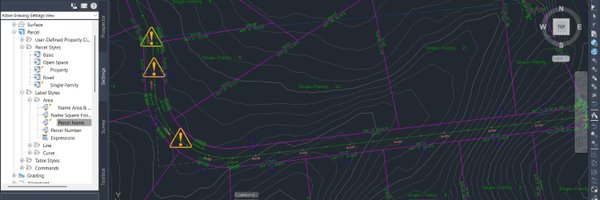
I am 48 hours into the immersive experience of utilizing ArcGIS Pro, and I must confess that it truly stands out as the "Ferrari" of the GIS world. Its impressive features include 3D mapping, advanced analytics, and an exceptionally user-friendly interface.
3
1
22
Mukuru demolitions on high-res imagery. Weak activism will have you sympathize with the demolitions of illegal settlements on riparian reserves. However, Remote Sensing empirically quantifies the need to clear these spaces for efficient hydrological processes and tree growth.
3
6
11
Danisa village, Tana River on 2024-05-14. The waters have so far subsided, and locals and school kids don't move around in canoes... ..but these events will return, in October, then next year in April, then October with increasing intensity.
3
1
15
Drone images I have collected across the Tana River spell a devastating flood extent of up to 1000m from the river center line. Villages and households I mapped 5yrs ago are all (still) flooded. A silent catastrophe.
This map forms a series of 47 base maps I created for demographics and household surveys for KNBS between 2017-2019. The exercise involved delineating counties into smaller enumerable areas of between 99-149 households. This exercise had me do over 2000kms of footwork in 2 years.
0
6
16
Risky buildings. Land is influenced by ownership, which denotes control. If NEMA is given legal custody of buffers on waterways and riparian areas like KENHA, KURA Kenya Railways, we'd make strides in restoring these ecosystems. Soils in this zone don't meet geotech standards.
3
31
52