
Infrastructure CGIs
@InfraCGI
Followers
9,754
Following
91
Media
96
Statuses
294
3D artist dreaming of streets with safe acrive travel infra. Support with:
Manchester, England
Joined February 2021
Don't wanna be here?
Send us removal request.
Explore trending content on Musk Viewer
Adalet
• 203112 Tweets
Gazze
• 119644 Tweets
ベイマックス
• 106032 Tweets
Chester
• 101089 Tweets
#サクサクヒムヒム
• 53867 Tweets
NANON LETSGO NYFW
• 46808 Tweets
#笑うマトリョーシカ
• 46341 Tweets
HAPPY BIRTHDAY TANNIE
• 39129 Tweets
#ساعه_استجابه
• 33501 Tweets
#dilanpolat
• 31415 Tweets
E. Jean Carroll
• 28909 Tweets
#2KDay
• 28903 Tweets
#DAY6_9th_Page
• 26759 Tweets
#4MINUTES_EP7
• 26706 Tweets
#浦島坂田船11周年
• 26285 Tweets
Franco Escamilla
• 26207 Tweets
#HAPPY_EJ_DAY
• 24461 Tweets
Game Day
• 22481 Tweets
Ayşenur Ezgi Eygi
• 18723 Tweets
#데이식스_청춘의_9번째_페이지
• 15949 Tweets
おぱんちゅうさぎ
• 15600 Tweets
BGYO DESERVES BETTER
• 10857 Tweets
Ocak
• 10025 Tweets


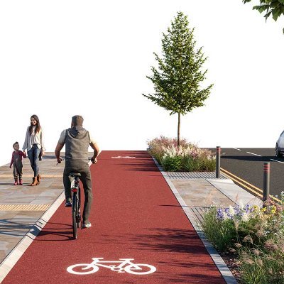
The space is there, it's what is done with it that enables travel choices
35
711
5K
This section of A road is a fairly typical 20 metres wide. Plenty of space to accommodate continuous cycle tracks protected by a planting buffer. Some side roads are filtered to prevent rat running
Support with:
or buy me a coffee:
47
643
3K
Every town and city needs a comprehensive protected cycle network....
23
451
2K
If city roads have safe options to walk, cycle or scoot ingrained into every artery then there is no need to have such vast amounts of space dedicated to cars and their storage.
Glasgow, Wishart St
33
252
2K
16.8 meters of typical UK road
vs
16.8 meters of my dreams


25
234
2K
Continuous pavements. Cars as guests. Cycle parking. Trees. Spacious pavements. EV vehicle & cargo bike share. Minimal private parking. Protected cycle tracks on main roads.
Vs
Majority of space is for private cars and car storage only
16
387
2K
A continuous bidirectional cycle lane, protected from vehicles by a planting buffer. Providing safe space for anyone to travel safely without using a car.
46
183
2K
A CGI to show how a modal filter can be a beautiful addition to the local streetscape whilst doing its job of preventing cut through motor traffic and still allowing active travel users to pass through unhindered. 🚲🌳
45
228
2K
York, but with more gentle pedalling and less angry revving...
40
107
1K
Roads should be safe and pleasant to use for all modes in all weathers. Protected, continuous active travels lanes, shielded from heavy vehicles by a buffer. Opening the option for all people to travel safely, not just the bravest few.
14
229
1K
Protected cycle lanes, cyclops junction, all green phase for walking & cycling.
Thanks to
@gloriousnse
for the original photo
38
142
1K


A road where everyone is free to chose an appropriate mode of travel to get around safely
vs
A typical fast cars only nightmare, where only the bravest dare to cycle or walk
9
202
814
The A635 between Ashton and Manchester could look like this if it had wide continuous cycle tracks and Cyclops junctions.
Support with:
35
129
743
An image to show how the Fallowfield Loop could look if its was upgraded from a relatively narrow, unlit shared-use path, to one with separate paths for cycles and pedestrians. Along with a new buffer zone for plants and lighting.
25
112
627
Come rain or shine, our roads should be a safe place for all people of all abilities and ages to travel safely.
6
110
610


An example of how a 4m wide bidirectional cycle track & pavement can pass, with priority, over the mouth of a one way side road by using Dutch Entrance Kerbs.
A wide planting buffer zone can provide spaces for other needs along the route, such as loading bays or cycle parking.

8
86
520
A quick transformation for a Patreon subscriber to show how protected bike panes could be added to Lido Boulevard in NY.
6
56
514
The A6 through Stockport could look like this if it had wide continuous cycle tracks and safe junctions.
Support with:
19
91
497
Level, uncluttered & wide cycle tracks. Space for people of all ages and abilities to make their journeys without using or interacting with multi-ton vehicles.
13
75
448
...What are kerbs for? does it really need them? The bollards are needed, so lets have those and do away with the level changes.
Safe, easy to use space for wheels and legs.


24
62
439
Level and continuous pavements & cycle tracks. Safe space for people to walk or cycle their daily journeys.
9
68
389
Hatching, painted cycle lanes, lumpy cluttered pavements...or smooth uncluttered space with wide continuous lanes for everyone to use in safety?
Support with:
7
67
335
A second CGI of Wokingham Rd in Reading. A vast road space wasted on hatching and painted lines. Instead it could have dedicated safe space for cycling with buffer planting and calmer traffic as a result.
Before photo by
@WhyIsaacDies
4
49
330
A 4m wide Bidirectional cycle track can allow users more space to ride at their own speed as there is a much greater opportunity for faster users to pass
Kerbs with a low forgiving angle mean the maximum width of the lane is available for users

9
49
298
A simple CGI diorama to show how Dutch Entrance Kerbs could be used to allow a continuous pavement and cycle track to pass a side road.
Planting can create a buffer to vehicle traffic.
Forgiving 30 degree kerbs between the track and the pavement allow the full width to be used

8
63
279
For anyone wondering...
Yes, the driver IS texting
I mean, I know massive A-frames and muddy gravel roads are a bit ridiculous, but we cant stray too far from the real world can we 😉
Support with:

2
41
243
A small change can visually make a big difference to the feeling of priority.
little game of spot the difference. Ver2 vs Ver1


13
31
214
Left: A country where Fuel 'Shortages' are a major problem
Right: A country where no one gives a flying F about fuel shortages
Support with:


6
31
182
A vision for transforming Whitworth St in Manchester UK into a pedestrianised boulevard with trees, planting, seating and a wide continuous bidirectional cycle track 🚲🌳🌿🛴
8
34
204
Priority at junctions for active travel road users & a wide bidirectional track 😀

1
18
141
Here's a work in progress snap shot of me making a Cyclops junction. If you'd like to see more work in progress and support the making of these images then please consider supporting Infra CGI on Patreon 😃

7
18
120
No one wants to share space with fast traffic.
Support with:

2
21
102
Finals for this e.g of a continuous footway & bidirectional cycle track
Wide and forgiving for people to safely have priority over turning vehicles. Space for comfortable overtaking, side by side riding
thanks to
@CatrionaSwanson
@RantyHighwayman
@RobertWeetman
for the feedback


2
12
83
Wokingham Road as a before and after:
Wokingham Rd in Reading has vast road space wasted on hatching and painted lines. Instead it could have dedicated safe space for cycling with buffer planting and calmer traffic as a result. Before photo by
@WhyIsaacDies
1
9
102
A transformation to how University Road in Belfast could look if it was reduced from 4 cars lanes down to 2, allowing space for continuous protected cycle lanes and SUDs planting 🚲🌿
3
17
89
Hey
@LauraKenny31
@JasonKenny107
Looks like you are riding down the A6 in the clip, even at the speed your legs can pedal I bet you'd prefer lanes like this to cycle on? 😄👇

Just an Olympic champion carrying another Olympic champion by cargo bike to get to their job training for the Olympics.
@LauraKenny31
@JasonKenny107
8
82
509
1
12
94
For one more sketch I've chosen a main road at random. This is Audley Rd in Stechford near Birmingham. Lots of driveways, lots of parked cars blocking pavements, lots of wasted space to hatching.
It'd be far better with Brummy blue cycle tracks & continuous pavements.


2
15
76
A rough sketch of the Greek St Roundabout in Edgeley, Stockport as a Cambridge 'Dutch' style Roundabout.
The Ordnance Survey data I'll need to buy for this will be around £70, donations welcome to help fund that at
Or support with:

10
15
81
Following on from the Ashton Old Rd sketch, here's a first draft of a Cyclops layout at the main junction in Openshaw.


7
7
79
A non gif version of the Floop image. If you'd like to play with a before & after slider there's one here:

6
6
77
A 4m wide Bidirectional cycle track can allow users more space to ride at their own speed as there is a much greater opportunity for faster users to pass
Kerbs with a low forgiving angle mean the maximum width of the lane is available for users

1
10
74
A view of separated cycle track and footpaths on a traffic free former railway. This time from the perspective of a foothpath user.
Want to see more CGIs of active travel infra?
Support with:
or buy me a coffee:

3
13
76
The A6 along here is a remarkably consistent width and could easily accommodate this type of layout, giving everyone a fairer share of the public road space.

7
7
78
A vision of Sheffield with a fully protected network of smooth red cycle paths 🚲🌳🌿
1
16
79
I prefer red, but green works just as well as long as the cycle tracks are wide, continuous and have priority.

3
6
61
This section of A road is a fairly typical 20 metres wide. Plenty of space to accommodate continuous cycle tracks protected by a planting buffer. Some side roads are filtered to prevent rat running
(reupload as twitter has broken some gifs)
1
11
57
Lovely stuff. It should be the norm for every side road crossing to be raised with entrance kerbs like that second photo.

A lot of interesting walking, wheeling and cycling infrastructure changes happening in Stirling! 🚶👨🦽🚲💚


10
17
172
0
4
62
@Chris_Boardman
What does leisurely look like?
I think it looks like safe protected lanes on the most direct routes.
People cycling at their own pace from one place to another.

2
5
59
An efficient, coherent network for people to get around their towns and cities safely on two wheels
Support with:
2
9
58
🙄
Before image: a carriageway for his buses, not the room for separate bus lanes and zero safe space for active travel
After image: a carriageway for his buses, not the room for separate bus lanes but high quality super safe infra for active travel

Sadly evidence of the lack of understanding of the urban transport challenge. Single minded prioritisation won’t achieve the modal shift towards sustainable travel that cities need.
2
0
5
5
6
49
A huge amount of roads in the UK are sub 15m wide. So I'm just scribbling on a typical UK estate road before going to 3D
How to get the room - make it 1 way?. Then whats best? uni or bidirectional track?
Parking formalised with EV charging islands and planting.
What do you think?


15
9
50
The A635 between Ashton and Manchester could look like this if it had wide continuous cycle tracks and Cyclops junctions.
(reupload as twitter has broken some gifs)
1
8
53
Just blown a £200 on the newest version of a plugin that lets me scattergun plants and trees alongside this lovely red cycle track! 😍😀
Support with:
or buy me a coffee

2
3
41
@justiemusica
‘Some’ side roads filtered to prevent rat running.
Disabled people use cycle tracks and pavements too.
1
0
46

It’s the big grey bit in the middle 👍😉
1
1
43
Exeter wins the poll. Thanks to everyone who voted!
First thing to remove is that ridiculous bridge…
🚲🛴🌳


6
5
45

The A635 is one of GM's many KRN roads (Key Route Network)
Thousands of people commute, shop and go to school along these routes but currently only the bravest dare cycle on them. With wide continuous tracks & protected junctions they could be open for everyone 😃

1
4
33
A space for everyone to safely get where they need to go isn't asking for much and would be worth every penny 😃


1
4
31
SUBMIT YOUR PHOTOS! 🙂
For the next view I’m inviting followers to submit a photo of their own road, path, former railway, or anything else to be reimagined. Please reply to this thread with your photo.
There’s a couple of essential things required: 🧵
16
14
35
About to set off for my commute to the day job, wishing I was the guy on the left there....

1
4
35
Buff is that feeling when you've had a good workout or a piece of clothing for your neck, but sometimes its the colour of your cycle track.

1
1
32
A CGI to show how space could be reallocated to create protected bike lanes and crossings on Route 6 through Fairhaven Massachusetts
0
5
39
The zig zag design is not for me and U.K. drivers make almost anything unmanageable, but if you just had this on EVERY road and street in a city, all continuously connected, you would suddenly have a functioning healthy transport network.

Leith Walk/Dalmeny Street continuous cycle way just about working as intended.
16
4
59
0
4
34

@andrew_desmier
What about the protected space for active travel the council has currently omitted?
2
0
34
Hatching, painted cycle lanes, lumpy cluttered pavements...or smooth uncluttered space with wide continuous lanes for everyone to use in safety?
(reupload as twitter has broken some gifs)
1
6
31
*Bookmark to do a visual of this kind of thing at some point in the future. 💦 🌱

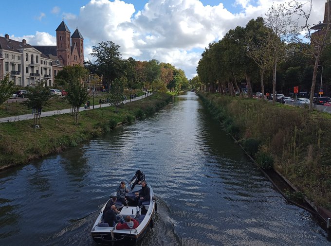
A photo I took on my first visit to Utrecht in 2015 and the same view today

28
464
4K
0
0
33
🤣

0
6
32
Wokingham Rd in Reading has vast road space wasted on hatching and painted lines. Instead it could have dedicated safe space for cycling with buffer planting and calmer traffic as a result.
Before photo by
@WhyIsaacDies


0
4
34
An image to show how the Fallowfield Loop could look if its was upgraded from a relatively narrow, unlit shared-use path, to one with separate paths for cycles and pedestrians. Along with a new buffer zone for plants and lighting.
(reupload as twitter has broken some gifs)
1
1
29
Testing out a new format for presenting my transformations 👇
I'll be creating a lot more in the coming months as well as being open for a limited number of commissions so if you have a space you'd like to see transformed then get in touch or support with Patreon😃🚲🌳🛴
A vision for transforming Whitworth St in Manchester UK into a pedestrianised boulevard with trees, planting, seating and a wide continuous bidirectional cycle track 🚲🌳🌿🛴
8
34
204
1
2
31
Which road should I make an image of next?
These are all roads in Edinburgh. Full pedestrianised?, Bidirectional cycle tracks?, Trees?, bus only?, Canal & punt? add your suggestions below
Poll in the next tweet 👇
Support with:

8
9
30
What to model next?
Like for Red lanes on Ashton Old Rd or retweet for blue in Brum


3
2
22
A little game of spot the difference for this morning.
Support with:


0
0
25
A wide road for fast driving & parking vs a pedestrianised public space with a bidirectional space for micromobility
Support with:
1
7
25
Really pleased to see 2x CGIs that I recently made for Bonn City Council in Germany are being well received. The layout will be tested in early 2024. Reducing Adenauerallee from 4 car lanes to 2, making space for safe cycling and new loading zones.

Verkehrsversuch auf der
#Adenauerallee
ab Januar 2024: Der Stadtrat hat gestern, 22. Aug., beschlossen, dass für drei Monate je Fahrtrichtung eine Fahrspur für den motorisierten Verkehr mit einem abgetrennten, sicheren Radfahrstreifen getestet werden soll:

12
5
65
0
2
20
More trees, more planting, more space for smooth, continuous, safe, cycle lanes. Less space for motor vehicles. Belfast, University Road.
Support with:
0
6
18
Here is the sketch design for the A6 posted on Patreon before starting the image.
Support with:

0
1
19
@mattcowburn1
There is still space for personal cars. Plus car share. Comprehensive network of protected cycle lanes available for all local journeys.
Non of my images are ‘proposals’. They’re ‘what could it look like if we took a different path decades ago’
1
0
18
A sketch for Ashton Old Road in Manchester(A635). This road is part of Greater Manchester's 'Key Route Network'.
I think this could look rather nice 🤓


1
1
15
@zero_stevie
@Owler_Nook
Haha. Well....😬
It is all plenty wide enough. Except for the brand new bridge over the newly widened Hyde Rd.
1
0
16