

India Meteorological Department
@Indiametdept
Followers
381K
Following
1K
Media
29K
Statuses
57K
This is the Official Twitter handle of India Meteorological Department, Ministry of Earth Sciences, Government of India.
New Delhi
Joined April 2016
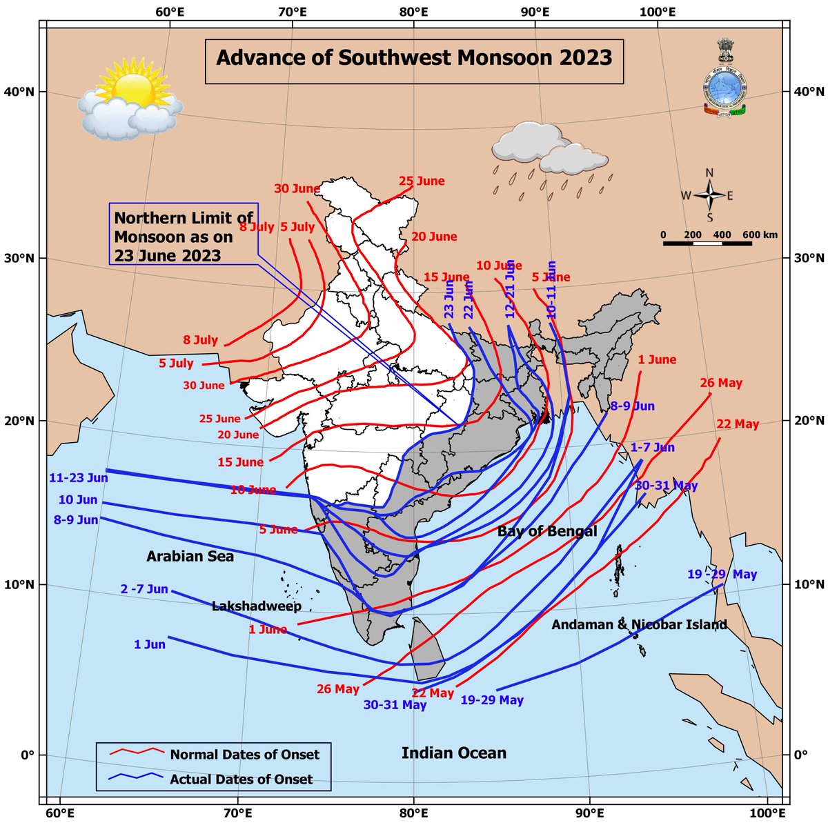
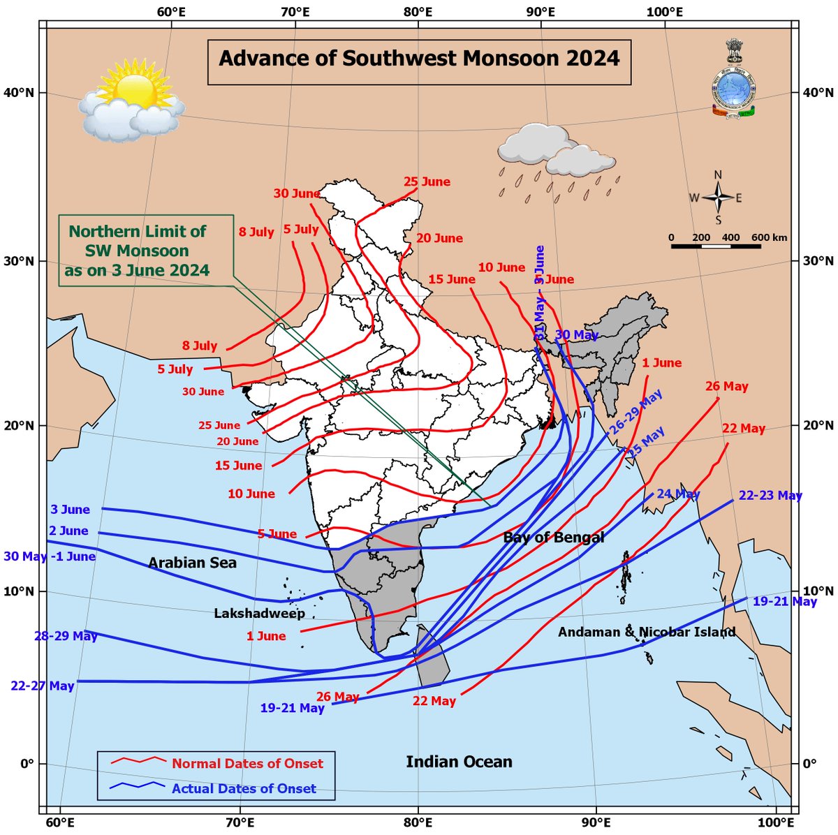
Southwest Monsoon has set in over Kerala today, the 08th June, 2023 against the normal date of 01st June.

44
974
9K
25th January 2025 . As per the configuration of the planetary system and different revolution periods of planets, it is rare to have all planets in a single frame of the sky. In January to February 2025 we can see the planets Jupiter and Mars on eastern sky, Saturn and Venus in

33
639
3K
Congratulations India !!! Dr. Mrutyunjay Mohapatra has won the election for the position of Third Vice President of WMO. A resounding victory. Received 113 votes (out of 148).
93
319
2K
Cyclone Tauktae.Diu reported 133kmph wind speed at 9.30 pm.
14
318
2K
Very Severe Cyclonic Storm YAAS to cross Odisha coast between Dhamra and Balasore around noon of 26th May with wind speed of 130-140KMPH.
14
241
2K
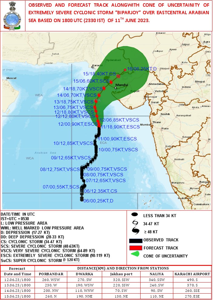
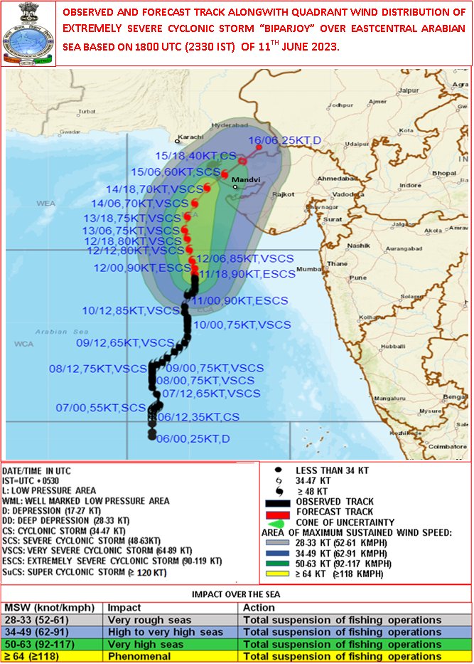
Cyclone Alert for Saurashtra & Kutch Coast: Orange Message. ESCS BIPARJPY at 0530IST of today over eastcentral & adjoining NE Arabian Sea near lat 19.2N & long 67.7E, about 380km SSW of Devbhumi Dwarka. To cross near Jakhau Port,Gujarat by noon of 15June.


10
224
2K
IMD has predicted landfall point of Cyclone "NIVAR" b/w Karaikal and Mamallapuram close to Puducherry in its 1st track forecast at 0530 IST of 23th Nov, i.e. 3 days in advance. Forecasted landfall point (3 days in advance) and actual landfall point r attached:


59
170
1K
Very severe cyclonic storm 'Tauktae' has intensified further in last 3 hours. The eye of the cyclone is now cleraly observed in the INSAT-3D satellite imagery at 1130 IST. The diameter of eye is roughly 4 km with eye temperature -5.2°C. The wall cloud top temperature is -93°C.
19
391
1K
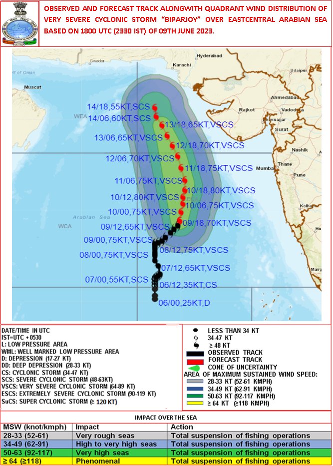
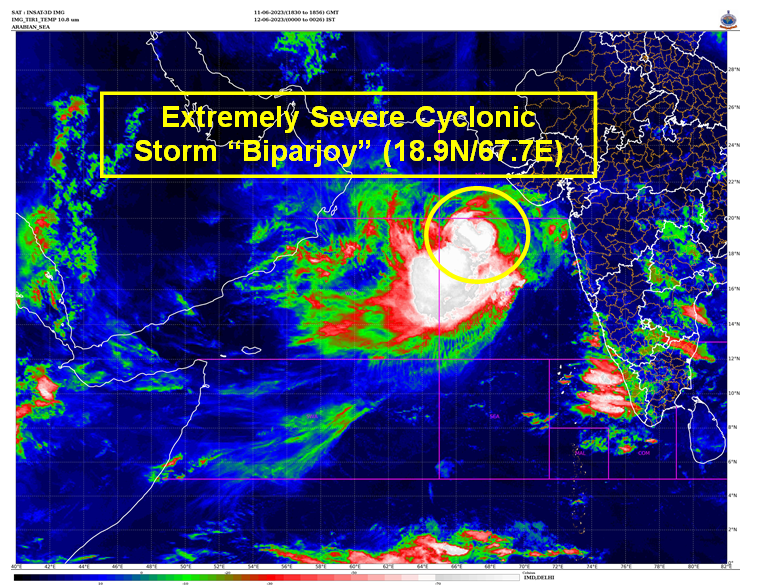
Deep Depression intensified into Cyclonic Storm BIPARJOY over Eastcentral Arabian Sea at 1730hrs IST. To move nearly northwards and intesify into a severe cyclonic storm during next 24 hours. For details kindly visit


13
154
1K
The Southwest Monsoon has further advanced into some more parts of Karnataka, Telangana, remaining parts of Andhra Pradesh, some parts of Vidarbha, Chhattisgarh, remaining parts of Northwest Bay of Bengal, remaining parts of Odisha & Gangetic West Bengal, 1/2
11
151
1K
VERY SEVERE CYCLONIC STORM YAAS CENTRED ABOUT 50 KM SOUTH-SOUTHEAST OF BALASORE.LANDFALL PROCESS HAS COMMENCED AROUND 0900 HRS IST.


18
245
1K
Extremely Severe Cyclonic Storm ‘AMPHAN’: 18th May 2020 (1000 to 1027 IST). Likely to intensify further as Super Cyclone.

43
444
1K
Southwest Monsoon has set in over Kerala and advanced into most parts of Northeast India today, the 30th May, 2024.
21
223
1K
Southwest Monsoon has set in over Kerala today, the 08th June, 2023. for more information: #India #IMD #heatwave #weather #WeatherUpdate, @DDNewslive, , @ndmaindia, @airnewsalerts, @moesgoi


10
167
1K
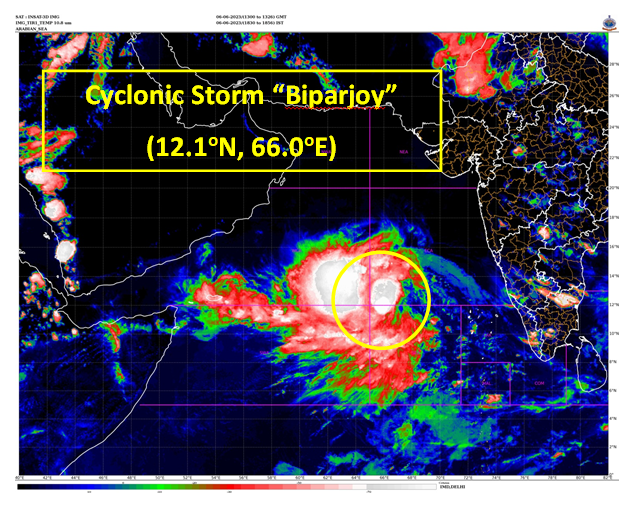
VSCS “Biparjoy” over eastcentral Arabian Sea, lay centered at 0530hrs IST of 10th June, near lat 16.5N & long 67.4E, likely to intensify further & move north-northeastwards during next 24 hours. More details:


10
143
1K
Southwest Monsoon has set in over Kerala today, the 29th May , 2022

22
202
1K
An Appreciation letter from WMO for accurate forecast and information dissemination during cyclon Amphan👏👏👏👏

37
154
988
LANDFALL PROCESS IS CONTINUING, IT WILL TAKE ANOTHER 03 HOURS TO COMPLETE THE LANDFALL PROCESS.
7
135
902
VSCS BIPARJOY at 2330 hrs IST of 09th June over eastcentral Arabian Sea near lat 16.0N & long 67.4E. Likely to intensify further & move north-northeastwards during next 24hrs. for details visit:

6
84
885
THE CENTER OF THE SEVERE CYCLONE "NISARGA" IS VERY CLOSE TO MAHARASHTRA COAST. LANDFALL PROCESS STARTED AND IT WILL BE COMPLETED DURING NEXT 3 HOURS. THE NORTHEAST SECTOR OF THE EYE OF SEVERE CYCLONIC STORM “NISARGA” IS ENTERING INTO LAND.
11
245
851
Cyclone Warning for Saurashtra & Kutch Coasts: Orange Message. VSCS BIPARJOY at 1730IST of today over NE Arabian Sea near lat 21.3N & long 66.5E, about 290km WSW of Devbhumi Dwarka. To cross near Jakhau Port (Gujarat) by evening of 15th June as VSCS. More:


4
145
859
In association with an east-west trough from Northwest Rajasthan to Northwest Bay of Bengal and huge moisture feeding to the trough from Arabian Sea and the Bay of Bengal; Intense monsoon clouds visible over East Rajasthan, north MP and East UP. 1/2

5
75
860
DEPRESSION OVER SE BoB AND NEIGHBOURHOOD NEAR LATITUDE 10.7°N AND LONGITUDE 86.5°E, ABOUT 1060 KM SOUTH OF PARADIP (42976) (ODISHA).TO INTENSIFY RAPIDLY INTO A CYCLONIC STORM DURING NEXT 12 HOURS AND FURTHER INTO A SEVERE CYCLONIC STORM DURING SUBSEQUENT 24 HOURS.


11
181
852
SCS ‘Yaas’ lay centred at 0530 hrs IST of today, about 320km SSE of Paradip, 430km SSE of Balasore, likely to move north-northwestwards, to cross north Odisha coast during noon of 26th May as a VSCS.


23
186
841
The ESCS TAUKTAE lies close to Gujarat coast. The landfall process started and will continue during next 02 hours.
17
229
820
The Deep Depression over Southwest Bay of Bengal intensified into Cyclonic Storm FENGAL (pronounced as FEINJAL) over the same region at 1430 hrs IST of today, 29th November.
5
103
831
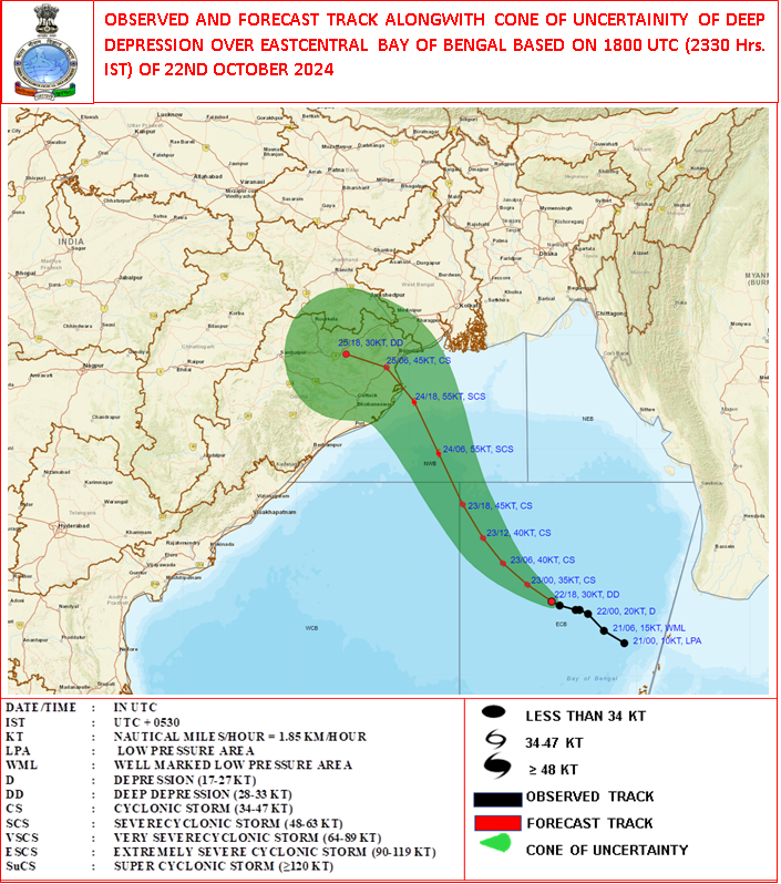
The Low Pressure Area over the Eastcentral Bay of Bengal and adjoining north Andaman Sea movedwest-nortwestwards and lay as Well marked low pressure area over eastcentral Bay of Bengal at 1130 hours IST oftoday, the 21st October 2024. It is very likely to move


10
111
819
Very Severe Cyclonic Storm “Tauktae” over Eastcentral Arabian Sea intensified into an Extremely Severe Cyclonic Storm: Cyclone Warning & post landfall outlook for Gujarat & Diu coasts (Red message).


10
254
776
Landfall process is continuing. It will take around 3 hours to complete. 30 km south-southeast of Balasore at 0930 hours IST.
7
102
791
SEVERE CYCLONIC STORM "NISARGA" CROSSED THE COAST BETWEEN 12:30 IST & 14:30 IST OF 03.06.2020 WITH A WIND SPEED OF 100-110 KMPH GUSTING TO 120 KMPH.
22
165
742
Weather is a chaotic dynamical system and very sensitive to any changes in its hundreds of parameters. Overcoming random states of disorder and irregularities and forecasting to serve the society and Human Welfare is the prime goal of IMD. We are always improving and updating us.
24
53
724
Cyclone Warning for Saurashtra & Kutch Coasts: Orange Message. VSCS BIPARJOY at 2330 IST of 13th June over NE Arabian Sea near lat 21.7N & long 66.3E, about 300km WSW of Devbhumi Dwarka. To cross near Jakhau Port (Gujarat) by evening of 15th June as VSCS.


3
76
704
Cyclone Alert for Saurashtra & Kutch Coast: Yellow Message. ESCS BIPARJOY over eastcentral Arabian Sea, at 1730 IST of 11th June near lat 18.6N & long 67.7E, Likely to cross between Mandvi (Gujarat) & Karachi (Pakistan) by noon of 15thJune. More details:


3
88
702
Deep Depression over Eastcentral Bay of Bengal intensified into Cyclonic Storm ‘Yaas’ and about 600 km of Port Blair. To intensify into a Severe Cyclonic Storm during next 24 hours and into a Very Severe Cyclonic Storm during subsequent 24 hours.


19
179
700
Southwest monsoon has further advanced into some more parts of Karnataka, Andhra Pradesh, Westcentral & Northwest Bay of Bengal; some parts of Gangetic West Bengal & Jharkhand; some more parts of Bihar & remaining parts of Sub-Himalayan West Bengal & Sikkim today, the 19th June.

6
98
687
Deep Depression over Eastcentral Bay of Bengal (Cyclone Alert for Odisha and West Bengal coasts: Yellow Message).The deep depression over Eastcentral Bay of Bengal moved west-northwestwards with a speed of 3 kmph during past 6 hours, and lay centred at 2330 hrs IST of yesterday,

4
53
667
VERY SEVERE CYCLONIC STORM ‘TAUKTAE’ MOVED NORTH WARDS WITH A SPEED OF 15 KMPH DURING PAST 06 HOURS.
1
62
646
🚨#Telangana is about to experience heavy to very heavy rainfall with extremely heavy falls (above 204.4 mm) on 5th December. Stay alert, stay safe!

9
121
650
Very Severe Cyclonic Storm ‘Yaas’ , located about 160 km east-southeast of Paradip (Odisha), 250 km south-southeast of Balasore (intensify further and to cross north Odisha-West Bengal coasts between Paradip and Sagar Islands during 26th May as a VSCS.


11
164
615
YAAS over Eastcentral BoB, lay centred at 1730 hrs IST of 24th May about 450 km south-southeast of Paradip (Odisha) and 540 km south-southeast of Digha (WB), move north-northwestward, to cross between Paradip and Sagar Island around Balasore, during noon of 26th May as a VSCS.


9
152
616
Landfall process has commenced and the forward sector of the wall cloud region is entering into land. The landfall process would continue till today, the 25th October morning. The system is under continuous surveillance of the Doppler Weather Radar at Paradip.
8
58
642
Extremely Severe Cyclonic Storm FANI about 450 km south-southwest of Puri at 0530 hrs IST of 02nd May, 2019. To cross Odisha coast around Puri by afternoon of 3rd May.


29
390
577
SOUTHWEST MONSOON HAS SET IN OVER SOUTHERN PARTS OF KERALA TODAY, THE 03RD JUNE, 2021. DETAILS IN THE PRESS RELEASE TO BE ISSUED SOON.@rajeevan61.
13
124
621
Cyclone Warning for Saurashtra & Kutch Coasts: RED MESSAGE. VSCS BIPARJOY at 0530IST of today over NE Arabian Sea near lat 21.9N & long 66.3E, about 280km WSW of Jakhau Port (Gujarat), 290km WSW of Devbhumi Dwarka. To cross near Jakhau Port (Gujarat) by evening of 15June as VSCS.


4
146
601
Extremely Severe Cyclonic Storm Tauktae.INSAT 3D satellite-based centre position .at 1030 IST - 19.1N & 71.5E .which is 193 km south-southeast of Diu

12
146
604
The CS YAAS intensified into a Severe Cyclonic Storm, lay centred at 1800 UTC of 24th May about 390km SSE of Paradip, likely to move north-northwestwards, to cross between Paradip and Sagar Island around Balasore, during noon of 26th May as a Very Severe Cyclonic Storm.


7
136
608
Depression has formed over eastcentral BOB at 1130 IST.Itwould intensify further and cross north Odisha-West Bengal coast betweenParadeep and Sagar Island by 26th evening as a Very Severe Cyclonic Storm. For more detail :


14
169
603
Super Cyclone AMPHAN is likely to make landfall between Digha (West Bengal) and Hatiya Islands (Bangladesh) close to Sundarbans as an Extremely Severe Cyclonic Storm with maximum sustained wind 165-175 kmph gusting to 195 kmph in the afternoon/evening of 20th May.


11
261
592
Eye of the cyclone is visible in Radar.
14
85
597
Southwest Monsoon is likely to advance into more parts of Maharashtra (including Mumbai) today the 09th June and likely to advanced into more parts of Telangana and Andhra Pradesh; some parts of Odisha and more parts of West Bengal during the next 2 days.

8
106
599
SUPER CYCLONE ‘AMPHAN’ CROSSED WEST BENGAL-BANGLADESH COASTS AS A VERY SEVERE CYCLONIC STORM WITH THE SPEED OF 155-165 KMPH GUSTING TO 185 KMPH ACROSS SUNDERBAN NEAR LAT. 21.65°N AND LONG. 88.3°E. AND LAY CENTRED AT 1930 HRS IST OF TODAY, THE 20TH MAY 2020.


15
149
575
Congratulations Team India !!! Dr. Mrutyunjay Mohapatra, DG IMD has won the election to the post of Third Vice President of WMO. A resounding Victory (113 out of 148 votes). @IndraManiPR @BarkhaTamrakar @moesgoi

18
76
583
Cyclone Tauktae update 00 IST 18th May 2021 .The entire eye of cyclone has now crossed the coast and lies overland. The rear sector of the eyewall is now entering the land.

9
111
580
Cyclone Alert for Saurashtra and Kutch Coast: Yellow Message. ESCS BIPARJOY lay over eastcentral Arabian Sea at 0830 IST today,460 km SSW of Porbandar,510 km SSW of Dwarka,600 km SSW of Naliya. To cross Saurashtra and Kutch and adj Pakistan coasts around noon of 15 June as VSCS.


7
140
570
Visible Image INSAT 3D (09:30-09:57 IST) 03-06-2020.Severe Cyclone "NISARGA"

5
154
566
VERY SEVERE CYCLONIC STORM ‘YAAS’ CENTRED ABOUT 40 KM EAST OF DHAMRA AND 90 KM SOUTH-SOUTHEAST OF CROSS NORTH ODISHA-WEST BENGAL COASTS TO THE NORTH OF DHAMRA AND SOUTH OF BALASORE NOON OF 26TH MAY AS A VSCS WITH WIND SPEED OF 130-140 KMPH.


12
151
573
Super Cyclone AMPHAN to cross West Bengal – Bangladesh coasts between Digha (West Bengal) and Hatiya Islands (Bangladesh) close to Sundarbans during afternoon to evening of 20th May 2020 with wind speed of 155-165 kmph gusting to 185 kmph.


16
179
563
A LOW PRESSURE AREA IS VERY LIKELY TO FORM OVER EASTCENTRAL BOB AND ADJOINING NORTH ANDAMAN SEA AROUND 22ND MAY, 2021. IT IS VERY LIKELY TO INTENSIFY INTO A CYCLONIC STORM BY 24TH. IT IS VERY LIKELY TO MOVE NORTHWESTWARDS AND REACH NEAR ODISHA-WEST BENGAL COASTS BY 26 MAY MORNING.
8
116
551
Super Cyclonic Storm ‘AMPHAN’ (pronounced as UM-PUN) : 18th May 2020 (1130 to 1157 IST).

8
97
554
Press Release: Southwest Monsoon has covered entire country including Delhi

16
94
547
Depression over eastcentral Bay of Bengallay lay centred at 1730 hrs IST of today, the 23rd May, 2021 about 590 km north-northwest of Port Blair. To intensify into a Cyclonic Storm by 24th May morning and further into a Very Severe Cyclonic Storm during the subsequent 24 hrs.


8
139
549
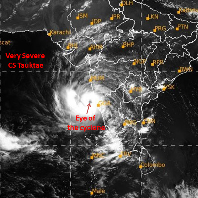
The Very Severe Cyclonic Storm “Tauktae” over eastcentral.Arabian Sea about 190 km northwest of Panjim-Goa, 270 km.south-southwest of Mumbai, 510 km south-southeast of Veraval (Gujarat). It likely to intensify further during next 24 hours.


9
165
542
Cyclone Tauktae.INSAT 3D satellite-based centre position at 2130IST.20.65N & 71.15E about 30kms east of Diu. The landfall process will continue for next 2hrs.

8
116
541
Cyclone Warning for Saurashtra & Kutch Coasts (Red Message) VSCS Biparjoy over Northeast Arabian Sea at 1730 hours IST of today, the 14th June, 2023 about 240 km southwest of Jakhau Port (Gujarat), 260 km west-southwest of Devbhumi Dwarka, 260 km west-southwest of Naliya.


4
86
540
3
66
522

Cyclone Alert for Saurashtra & Kutch Coast: Yellow Message. ESCS BIPARJOY over eastcentral Arabian Sea, at 2330 IST of 11th Jun near lat 18.9N & long 67.7E, Likely to cross between Mandvi (Gujarat) and Karachi (Pakistan) by noon of 15thJune. More details:
2
92
534

Extremely Severe Cyclonic Storm ‘AMPHAN’ with Eye Pattern: 18th May 2020 (0730 to 0750 IST)

13
181
530
Cyclonic Storm “FENGAL” over Southwest Bay of Bengal moved west-northwestwards with a speed of 12 kmph during past 6 hours and lay centred at 0530 hours IST of today, the 30th November 2024 over the same region near latitude 12.2°N and longitude 81.2°E, about 150 km east of


3
82
547
Warm wishes to the 42nd ISEA Wintering Team at #Maitri and #Bharati in #Antarctica! Your resilience and dedication in overcoming polar night challenges embody the true spirit of Antarctic exploration. Your contributions to climate research are invaluable.


3
69
535
VSCS ‘YAAS’ CROSSED NORTH ODISHA COAST ABOUT 20 KM SOUTH OF BALASORE DURING 1030 TO 1130 HOURS IST OF TODAY WITH ESTIMATED WIND SPEED OF 130-140 KMPH GUSTING TO 155 KMPH.THEN MOVED NW-WARDS AND AT 1130 HRS IST,CENTRED NEAR 21.4°N/86.9°E ,ABOUT 15 KM SSW OF BALASORE.


13
115
520
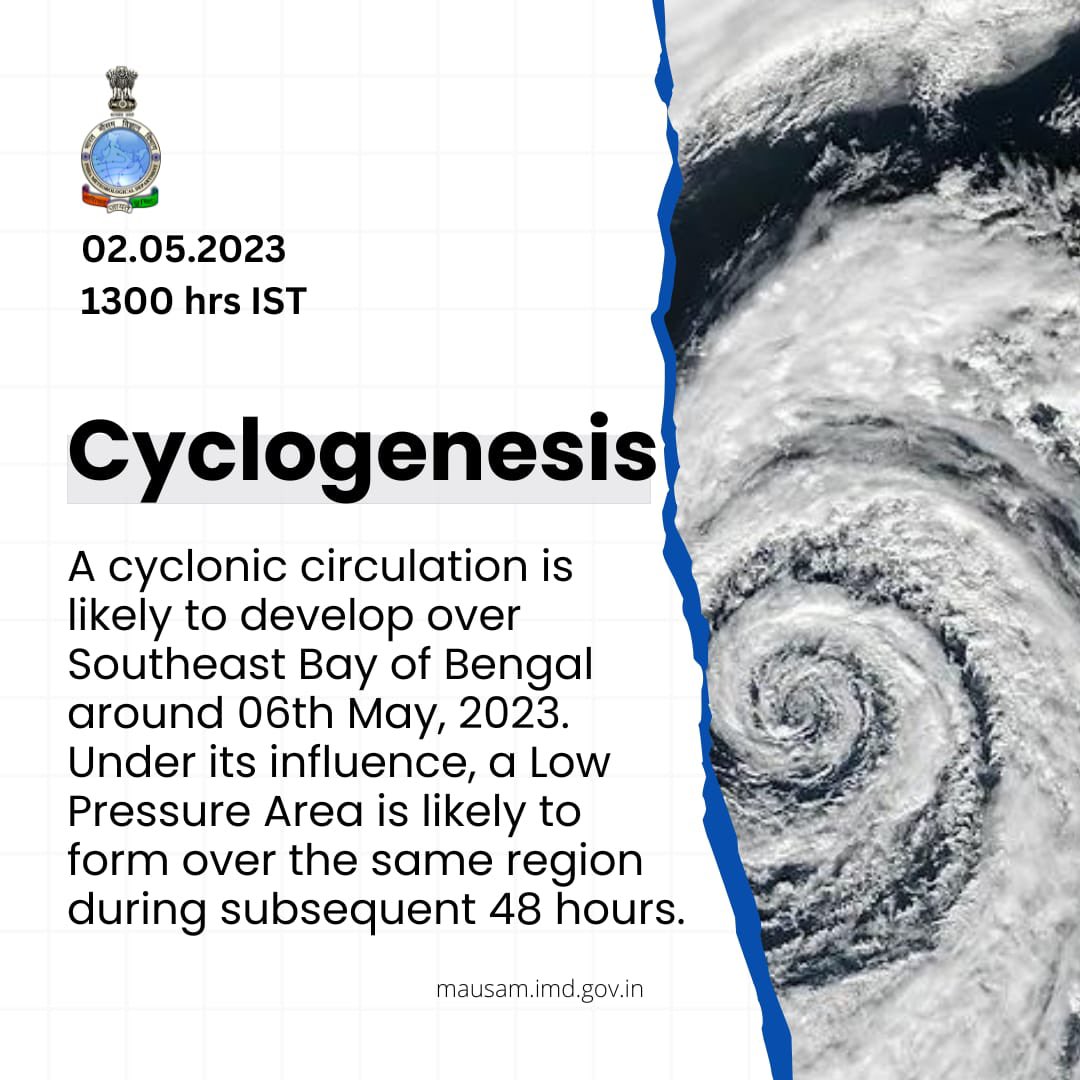
A cyclonic circulation has formed and lay over the southeast Bay of Bengal and neighborhood at 0830 IST of today. LPA is likely to form by 8th May, morning and Depression around 9th May. Visit for more details.


2
78
525
VSCS Biparjoy over Northeast Arabian Sea at 0230 hours IST of 15th June, 2023 about 200 km west-southwest of Jakhau Port (Gujarat). To cross Saurashtra & Kutch and adjoining Pakistan coasts between Mandvi and Karachi near Jakhau Port by evening of 15th June as a VSVS.


5
103
515
Southwest Monsoon advanced into some more parts of central Arabian Sea, some more parts of Karnataka, Rayalaseema, Coastal Andhra Pradesh, some parts of Telangana and some more parts of Westcentral and Northwest Bay of Bengal, today the 3rd June.
6
104
527
दक्षिण-पश्चिम बंगाल की खाड़ी के ऊपर स्थित चक्रवाती तूफान "निवार" बीते छह घंटे में 05 किमी प्रति घंटे की गति के साथ पश्चिम की ओर बढ़ा और भारतीय समयानुसार आज शाम , 24 नवंबर, 2020, 1730 बजे दक्षिण-पश्चिम बंगाल की खाड़ी में अक्षांश 10.0°N एवं देशान्तर 82.4°E पर केंद्रित है |


712
53
494
IMD model with the satellite image has generated by METCAP for the Extremely Severe Cyclonic system TAUKTAE at 1430 hrs IST

12
104
503
LANDFALL: VSCS BIPARJOY moved northeastwards and CROSSED Saurashtra-Kutch coast near Jakhau Port (Gujarat) between 2230 & 2330 IST of 15th June as a VSCS with windspeed of 115-125 kmph.
4
102
517
To get information about lightning occurrence and its forecast by IMD/MoES in your area, please download:.1. DAMINI app .2. RAIN ALARM app.3. UMANG app .4. MEGHDOOT app .5. MAUSAM app . All the above APPS are available on Android and IOS.
17
122
505
The SUPER CYCLONE ‘AMPHAN’ over west-central Bay of Bengal, lay centered at 1730 hrs IST of today, the 18 th May, 2020 over west-central Bay of Bengal near latitude 14.0°N and longitude 86.3 °E, about 700 km nearly south of Paradip (Odisha).


8
172
501
Depression over Eastcentral Bay of Bengal intensified into a Deep Depression and about 600 km north-northwest of Port Blair. To intensify into a Cyclonic Storm by 24th May morning and further into a Very Severe Cyclonic Storm during the subsequent 24 hours.


6
94
514
Isolated heavy rainfall likely over Jammu & Kashmir, Ladakh, Gilgit, Baltistan & Muzaffarabad on 05th; Himachal Pradesh on 05th, 07th-09th & Uttarakhand during 07th-19th July. Isolated heavy to very heavy rainfall over Himachal Pradesh on 06th and Uttarakhand on 05th & 06th July.
14
114
505
Extremely Severe Cyclonic Storm Tauktae.INSAT 3D satellite-based centre position .at 1130 IST - 19.2N & 71.5E .Distance from Diu is 182km (South-southeast).Distance from Mumbai is 142km (west-northwest)

4
117
499
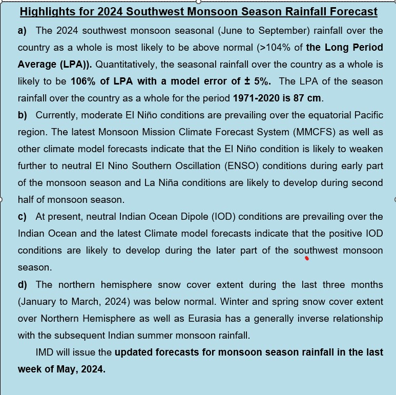
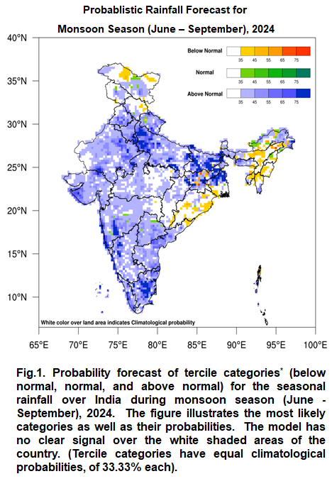
IMD predicts 2024 southwest monsoon season (June to September) rainfall over the country as a whole to be above normal (>104% of the Long Period Average (LPA)). Seasonal rainfall is likely to be 106% of LPA with a model error of ± 5%. LPA of monsoon rainfall (1971-2020) is 87 cm.
16
129
517
Cyclonic storm “DANA” (pronounced as Dana) over Eastcentral & adjoining westcentral Bay of Bengal moved northwestwards with a speed of 12 kmph during past 6 hours and lay centred at 1730 hrs IST of today, the 23rd October, over the same region near latitude 17.2° N and longitude


3
71
517
AMPHAN crossed West Bengal-Bangladesh coast between Digha (West Bengal) and Hatiya Islands (Bangladesh) across Sunderbans near lat 21.65N & long 88.3E between 1530 & 1730 hrs IST of 20th May with wind speed of 155-165 gusting to 185 kmph.


16
169
501
THE VERY SEVERE CYCLONIC STORM ‘TAUKTAE’ MOVED NORTH-NORTHEAST WARDS WITH A SPEED OF 11 KMPH DURING PAST 06 HOURS.
10
56
501
Heavy to very Heavy rainfall with isolated Extremely Heavy rainfall expected over Coastal Andhra & Yanam, Rayalaseema & Tamil Nadu on 03rd & 04th December.

2
100
501
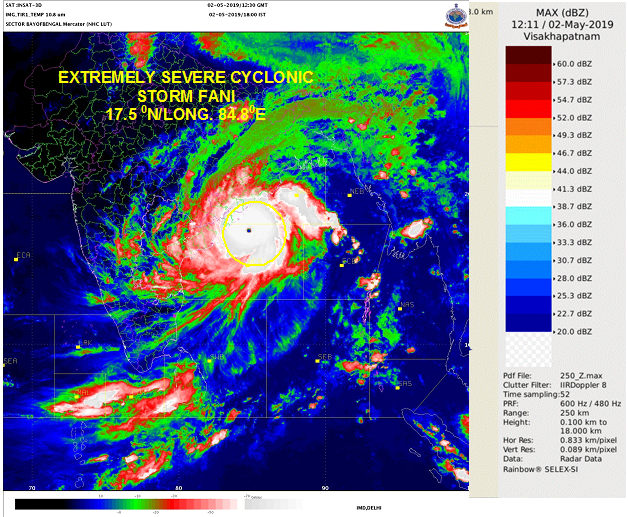
ESCS FANI centered near 17.4 N/84.8E over westcentral Bay of Bengal at 1730 hrs IST about 275 km SSW of Puri & 160 km ESE of Visakhapatnam. To cross Odisha coast between Gopalpur & Chandbali around Puri during forenoon of tomorrow, the 3rd May.


12
335
475
Cyclonic storm 'NIVAR' over Bay of Bengal lay centred at 0830 hrs IST of 24th Nov, about 410 km east-se of Puducherry. To intensify further into a SCS during next 24 hrs. To cross Tamil Nadu and Puducherry coasts during 25th Nov evening as SCS with a wind speed of 100-110 kmph.


9
132
489
At 0830 IST, SCS ‘Yaas’ about 280 km south-southeast of Paradip. To intensify further and cross north Odisha-West Bengal coasts between Paradip and Sagar Island close to north of Dhamra and south of Balasore, during noon of Wednesday, the 26th May as a Very Severe Cyclonic Storm.


17
117
488
Cyclone Warning for Saurashtra and Kutch Coasts: Orange Message. VSCS BIPARJOY at 0830IST of today about 280km SW of Devbhumi Dwarka, 300km WSW of Porbandar, 310km SW of Jakhau Port, 330km SW of Naliya. To cross near Jakhau Port (Gujarat) AROUND evening of 15th June as VSCS.


3
118
491
Cyclone Tauktae update.At 2230 IST - centre of the cyclone now lies overland about 20kms East-northeast of Diu. The landfall process will continue for next 2hrs.

16
129
492
Super Cyclone AMPHAN to cross West Bengal – Bangladesh coasts between Digha (West Bengal) and Hatiya Islands (Bangladesh) close to Sundarbans during afternoon to evening of 20th May 2020 with wind speed of 155-165 kmph gusting to 185 kmph.


11
173
492
A low pressure area formed over Southeast & adjoining Eastcentral Arabian Sea and Lakshadweep area. To concentrate into a Depression over Eastcentral and adjoining Southeast Arabian Sea during next 24 hours and into a Cyclonic Storm during the subsequent 24 hours

15
135
488
Improvement in the current monsoon Season’s rainfall over India: Monthly cumulative all India rainfall for 1-27 June 2023 over India reached -19%, in terms of % departure from long period average for the same period. It was -51% for the period from 1 June till 15 June 2023.


4
67
491
Southwest Monsoon has covered entire country today, the 02nd July 2022.
10
72
490
Earthquake of Magnitude:6.3, Occurred on:24-09-2019, 16:31:58 IST, Lat:32.9 N & Long: 73.7 E, Depth: 40 Km, Region: Pakistan - India (J & K ) Border region

23
312
459