
Matthew Gross
@HurricaneAddict
Followers
1,401
Following
406
Media
460
Statuses
1,332
Fascinated by extreme weather! (I post fantasy hour model runs for entertainment, not to forecast. If it's beyond Day 7, it's probably not a legitimate threat.)
Westerly, Rhode Island
Joined June 2021
Don't wanna be here?
Send us removal request.
Explore trending content on Musk Viewer
É OURO
• 410570 Tweets
バニーの日
• 409332 Tweets
Bia Souza
• 310538 Tweets
Kyle
• 188091 Tweets
Canadá
• 187666 Tweets
Beatriz Souza
• 169310 Tweets
#แบดมินตัน
• 154769 Tweets
サッカー
• 103540 Tweets
Teddy Riner
• 101358 Tweets
#4MINUTES_EP2
• 90102 Tweets
スペイン
• 88871 Tweets
ELVISH INCOMPARABLE WINNER
• 85738 Tweets
オフサイド
• 77596 Tweets
Fermin
• 46844 Tweets
Emily
• 46728 Tweets
Gallagher
• 37905 Tweets
Ron Paul
• 34795 Tweets
Olmo
• 32048 Tweets
Ekrem İmamoğlu
• 26266 Tweets
Fresh News for $XRP Holders
• 24106 Tweets
異界入り
• 19756 Tweets
Game Informer
• 17756 Tweets
#LakshyaSen
• 17693 Tweets
シュート
• 16762 Tweets
$BCCOIN
• 16361 Tweets
ジャッジ
• 10907 Tweets
GameStop
• 10549 Tweets


Pinned Tweet

Happy Hurricane Season to all who celebrate!

7
13
110
The severity of what’s about to occur in Nova Scotia on Friday night cannot be overstated! A hybrid hurricane will result from the violent phasing of a sharp cutoff trough and major hurricane Fiona moving into the same waters well east of New England.
(Here comes a thread)

41
420
1K
Idalia is the main focus right now for obvious reasons, but it's worth noting that today's Euro ensembles light up the MDR next week with several members sending storms of CAT 4 and CAT 5 intensity into the western part of the basin in the long range.

25
83
392
A heartbreaking disaster! Mocha’s landfall point looks to be very close to the Myanmar /Bangladesh border, which houses the largest refugee camp in the world for the heavily persecuted Rohingya people. This is where the intersection of climate disaster and geopolitics meet.
16
157
286
The 18z Euro ensembles for a Lee are a complete disaster for southern New England! Plenty of time for these to jump back east in future runs, but many of these members show the worst storm that region has seen in decades!
30
56
272
The HAFS-B hurricane model just went pants off on its 12z run! Says Lee will become a 200 mph CAT 5 in JUST 24 HOURS!!!!!

16
47
265
LAWD HELP US IF THIS HAFS-B RUN VERIFIES! This would basically be New England's Sandy verbatim! Headed NW at the end of the run. Lots of time left for this to change!
20
39
264
Oddly, that cold wake combined with the ventilation from Lee (assuming he becomes a high end major cane), could work to strengthen the Bermuda High in the mid range in that spot more than modes expect. If that happens ... (1/2) ...

Soon-to-be Major Hurricane Lee will traverse high ocean heat content [OHC] water ENE of the Leeward Islands and Puerto Rico in the tropical Atlantic over the next 5-days.
However, slow moving, large Hurricane Franklin wiped out the OHC thereafter. Amazing "cold wake"

15
66
397
8
23
246
THE GFS JUST PULLED OFF THE HOLY GRAIL STORM!!!! HURRICANE HITS FLORIDA AND RUNS UP THE EAST COAST WHERE IT PHASES WITH AN ARCTIC AIRMASS! WOULD BE AN ALL TIME WEENIE EVENT!
24
23
231
The Korean model just showed Hurricane Lee pulling a 1938 redux!!! New England better pray this model is as unreliable as most people think!😲😲😲
19
26
178
When this occurs, Fiona will receive a tremendous injection of 500 mb energy, causing her pressure to drop and her wind field to expand. The result will be a storm unlike Nova Scotia, or all of Canada for that matter, has ever seen.
5
17
157
... not only would it force Lee further west before his turn to the north, but could ultimately get him beyond 72 West where he would miss the cold wake altogether and end up in even warmer, untouched waters. Fascinating wrinkle in this forecast!
3
14
151
We have a Holy Grail member in today's European ensemble package! Say hello to special member No. 33, which shoots a hurricane out of the western Caribbean, phases it, bombs to 939 mb as it landfalls in Maine, and dumps several feet of snow on New York state's interior! 😂😂😂
7
17
138
There were some massive changes in the 500 mb look at the end of today's Euro run. A trough likely to sweep anything in the western Atlantic out to sea from previous runs has completely disappeared from that timeframe, and now the question is, what happens next?


6
19
134
Euro ensembles today took a big step towards a significant event in the Gulf!

11
14
131
Why does the 12z Euro slam Hurricane Lee into New England when most of its ensembles do not? The answer is Margot. The parent Euro run kicked Margot way east (at the black "x" in the second picture) allowing the ridge to build strong into Atlantic Canada and block Lee's exit.


9
18
121
So much of our knowledge of how to prepare for storms in comes from the lessons other benchmark storm taught us; but unfortunately for Nova Scotia, this is going to be THE new benchmark storm, and all the lessons won’t be known until after
#Fiona
is done unleashing her fury.
8
10
115
And none of the native plant population is used to experiencing that. There will be unprecedented forest loss, and any buildings or structures located near Nova Scotia’s copious tall trees will be in danger of failure as the falling flora will punch holes, or ...
1
10
102
Two of the GFS ensembles have the Holy Grail Storm from 12z yesterday. One is so severe it hits Tampa Bay as a CAT 4 and then runs up the I-95 corridor where it violently phases with an arctic trough and dumps more than a yardstick worth of snow up the spine of the Appalachians.


11
12
103
The 12z HAFS-B run has Hurricane Lee successfully complete an eyewall replacement cycle and drops the pressure down to 912 mb by Wednesday evening!

7
14
100
The all time historical low pressure record anywhere in Canada is 940.2 mb, and that was from a winter storm in Newfoundland back in January of 1977.
1
3
90
With Fiona, most models are suggesting a pressure getting down to around 930 mb at the time of landfall, with some more aggressive guidance going even lower than that.
1
1
90
The impacts of such an extreme event will be felt all over Nova Scotia, but they will especially severe in the beautiful Cape Breton Island area (as well as any other place that ends up east of the eye). Here, winds could gust over 125 mph from a southerly direction ...
3
6
90
Hurricane Don singlehandedly upwelled the only part of the North Atlantic that has below average sea surface temperatures.


6
15
88
Euro ENS look a lot like the seasonal forecasts showing the combination of a raging El Nino & a well above average hurricane season in the Atlantic happening simultaneously. El Nino makes the low lats a ghost town, but to the north, the steaming hot basin kicks things into gear.

10
9
86

Lastly, because this storm is going to be stronger than anything we have in the record book for this region, and because it’s approaching from an angle of attack that is rarely seen, there’s going to be additional surprises.
1
2
78
In this case, it’s not just the wind, it’s the weaponry!
In addition to these winds, Fiona’s immense size (after she phases with the trough) will push record breaking surge for the area into bays, inlets, and coastlines across the province.
1
2
79
even complete destroy parts of roofs or other sections of houses and buildings. Once this damage is inflicted, Fiona’s ferocious winds will continue to erode the wounded structures in ways that stronger winds in tropical regions with fewer deciduous trees can’t match.
1
0
75
To the west of the eye, rainfall totals will be extreme. Here, winds may struggle to gust over 100 mph, but the combination of the plant life, fresh water flooding loosening roots, and winds still gusting to hurricane force easily be enough to cause enormous problems.
1
4
73
For now, these types of conditions west of the eye are likely to include Nova Scotia’s largest city, Halifax.
1
2
66
Models are showing a remarkable reduction in Saharan dust over the Atlantic during the next five days. Will be interesting to see how the basin responds to this dramatic change.
3
12
68
The GFS is starting to get frisky with the fantasy storms again.😂

4
4
65
Today's 12z Euro for Fiona's Nova Scotia landfall. OMFG!!! 😲😲🚨🚨🚨

4
10
58
What a signal from the 18z GFS ensembles at Day 6! Starting to get close enough now where genesis and a hurricane in the western Caribbean might become a legit threat and not just model fantasy. (Anything the storm does after this point is still highly suspect.)

1
12
56
12z Euro ensembles in motion:
(Numerous members slam into Nova Scotia!)
4
7
56
The area that I think has the best chance to "overperform" with next Tuesday's storm.

6
8
56
The Hurricane models are completely off their rockers tonight!


3
7
53
WOW! The GFS is showing a worst case scenario track for Shanghai, China next week w/ Khanun! This would be aCAT 3+ typhoon making a direct landfall on one of the biggest and most populated cities in the world. The coastal flooding from a landfall at this angle would be immense!


5
17
51
The HWRF continues to show Tropical Cyclone Mocha making a run at CAT 5 status before landfall. (The Euro and GFS remain less bullish.) Either way, this will be a complete disaster for Myanmar.

1
10
49
Future Hurricane Lee may become a big problem for Atlantic Canada (and possibly even the northeast U.S.) if these trends of more aggressive ridging continue.


7
8
49
Doing some comparisons in front of Idalia and this is rather alarming.

5
2
48
It's wild how close of an analog 1953 Carol (NOT 1954 Carol) is for Hurricane Lee.
1) Very similar track north of the Caribbean islands
2) 1953 Carol became a CAT 5 at low latitude
3) Both occurred in the first half of September
4) Both were in El Nino years

6
4
49
HO-LEE SHITBALLS!!!! The latest HWRF bottoms Fiona out at an astounding 917 mb when it fully phases with the 500 mb cutoff low about 12 hours before the Canadian landfall! This is all occurring at about New Jersey's latitude, so just imagine the chaos if this had more longitude.

3
7
44
This might be the best looking tropical depression I've ever seen! Time to slap a name on it!
7
6
46

Notice the southern edge of the NHC's 11:00 pm cone, leaving the door open for a possible due west turn around 20 degrees latitude.

4
10
46
The 12z GFS now shows a borderline CAT 1 hurricane plowing directly into southern California! 😲

3
4
47
Gonna be hard to top the Korean model for weeniest run of the day.

6
2
44
The GFS just caved to the Euro ensembles and has a hurricane in the MDR by Saturday. 😂😂😂

2
2
40
There is overwhelming support among the GFS ensembles for a low latitude riding MDR hurricane headed for the Lesser Antilles next week.

3
2
41
What in the world is going on in the waters southeast of New England?


6
3
38
18z Happy Hour GFS again holds serve as event time creeps closer. Caribbean CAT 4 by Day 7 now! Turns north and hits south Florida this run as a major hurricane where it dumps 15 inches of rain on Miami. (No tropical phaser up the coast though as it doesn't time the trough.)


4
7
41
Wow! Euro cutting it awfully close for Cape Cod before hammering Maine!


3
7
39
Last night's Euro ensembles are much more aggressive in clearing out subtropics in the short term. Majority of the members now get the MDR system to the lower Bermuda Triangle around Day 10. What happens beyond that point as far as steering currents go is unknown.

6
7
41
18z GFS has a major hurricane striking the U.S. as CAT 3 barrels into both the Virgin Islands and Puerto Rico. 😮

9
4
36
The HWRF is showing an 896 mb behemoth crashing into Bangladesh on Sunday! Bangladesh has 170 MILLION people, and the majority live in a low-lying river delta where the Ganges meets the Bay of Bengal. Verbatim, you'd be talking about one of the deadliest storms in human history!


3
14
36
@BeachGlassFan
@cathyjo27344284
Listen to your local officials. In general, you want to be in well built structure in a place away from low elevation to avoid flooding, and away from large trees that can fall on the structure.
2
0
34
Invest 97L has moved far enough west this morning to enter a pocket of low wind shear in the central Caribbean. Convection still isn't all that impressive, but within this zone any convection it does manage to produce near the center over the next 36 hours is more likely to hold.


4
3
37
@WoftheFallLine
There would be more rising air in all the warmer water around that spot, so air would be more likely to sink between the warm pockets. So as a Bermuda High naturally tries to form in the area, it could anchor and strengthen from that particular spot.
1
2
36
12z Euro coming well northeast of previous runs. Might not even landfall in the U.S. this time. My how the mighty have fallen!

2
3
35
This is like watching a major hurricane make landfall in the middle of the last century. No warning! No radar! No chasers on the ground! Just a bunch of people in imminent danger with no way out and no time to evacuate.
2
6
33
The orientation of the ridging over the last 24 hours has really trended to blocking Lee's path and slowing the storm down as opposed to building over the top and shoving it west. Going to be very hard to gain longitude with these changes.

2
6
33
Poetry in motion on the GFS tonight for the weenies:
7
1
31
The 6z GFS took a wild turn on multiple fronts!
1) Turns the coastal low into a CAT 1 Hurricane off the Mid Atlantic this weekend.
2) Keeps the MDR wave weaker longer where it reemerges as a TS landfalling in the islands.
3) Shows snow in the upper Midwest at the end of the run.


2
7
30
For the first time all year, the Euro ensembles as looking legitimately frisky in the second half of their run. The majority (as in more than 50%) still don't have anything noteworthy, but the ones that do are showing potentially high impact events. Welcome to ASO! (Aug-Sept-Oct)


3
1
30
Hurricane Lee is fluctuating in intensity this morning, and that could be a big problem for any region that may get hit by this down the road. More detail as to why in the text image here:


4
7
29
The more I look at the overall setup surrounding Hurricane Hilary, the more I think California is in big, BIG trouble! Even though the chilly west coast waters that generally protect this region from tropical threats should work their magic again and
2
3
29


The 0z Euro shows the initial 500 mb cutoff low leave behind some vorticity that ends up briefly capturing Lee and drags him back dangerously close to Cape Cod. All interests in eastern New England should monitor this trend closely!
1
2
29
What type of voodoo do the northeast weenies have to enact in to get this to verify? 😂


3
3
29
@iCyclone
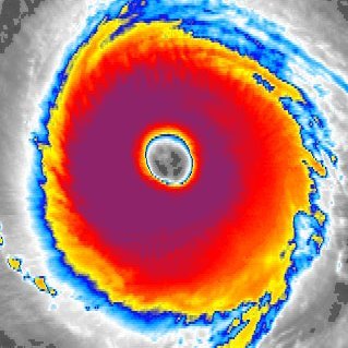
As far as tropical systems go at 47 degrees north, that's a damn beauty queen right there.
1
0
26
Can't wait for tomorrow after all the weenies post long range GFS images of tonight's run showing a major hurricane impacting the Mid Atlantic and the general public who have no idea how models work think this is Lee. Gonna be total chaos now! 🤣🤣🤣

3
2
28

The GFS got even more drunk than usual tonight! What a clown show!🤡🤣
1
3
28
Not only is there a large storm signal along the east coast in the February 28th / March 1st timeframe, but we're also seeing a strong signal of a 50/50 low east of Newfoundland and a plunging NAO around those dates, which makes me think this particular threat might be legit.


7
4
27
For at least the first half of August, a powerful ridging pattern looks to dominate the central Atlantic from the Azores to Bermuda. We'll have to see if this pattern persists, but if it does, it spells big trouble for the east coast once tropical systems start forming under it.
0
5
23
The Canadian and Euro ensembles are having a slight disagreement this evening:


1
2
26
Imagine the millions upon millions of trees this is going to take down. Nova Scotia's landscape is about to be changed forever!


6
11
23
@Rh15078Rh
A stronger Bermuda High is bad for coastal resident in New England and the Mid Atlantic. The stronger the High, the more it will force Lee's path west.
0
0
25
What a cave job by the GFS! 😂😂😂 Looks like the Euro is going to win this round.


2
2
24
The Euro and its ensembles are in good agreement that the Atlantic basin will wake up around August 20th. While it's dabbled with this idea for development from about the 15th onward, it's really been steadily up ticking the activity signal around the 20th. RING THAT DAMN BELL!!!


3
3
23

@AnnBar99035723
Very similar. Long duration hurricane force wind gusts, record breaking storm surge, and significant fresh water flash flooding. Best place to be is 20 feet or more above sea level in a structure not in danger of getting hit by falling trees.
0
0
21

The further west Margot ends up, the more it cuts into the ridge's ability to build, which allows Lee to escape east into Atlantic Canada. Conversely, the further east Margot ends up, the more the ridge builds, the more Lee gets blocked, & the more likely we get big U.S. impacts.
1
2
23
@hurricanetrack
Unfortunately in some circles the Ian experience will only make this worse. Many people who evacuated Tampa last year and didn't get the worst will refuse to do so this time and get caught in disaster. This scenario played out in New Jersey in 2012 with Sandy a year after Irene.
4
0
23
One of today's 12z GFS ensemble members takes a hurricane out of the western Caribbean, shoots it north, and fully phases it with a mid latitude trough, which allows it to bomb to 930 mb in the Gulf of Maine. 😂

2
1
22
By the way, the crazy Gulf coast cane the 0z GFS showed would be the "I" storm verbatim for that run. That might be the best evidence we have that it's a real signal! 😂


3
2
19

The track of Hurricane Lee (if the storm hooks back to the northwest right near Cape Cod as some models are showing) could be very, very bad news for Boston Harbor! Here's why this threat and this track could be so unique, and so dangerous for the city:


1
3
22
I mean ... YIKES!!!!!!

The Korean model just showed Hurricane Lee pulling a 1938 redux!!! New England better pray this model is as unreliable as most people think!😲😲😲
19
26
178
1
4
19
Invest 97L has officially been designated this evening. Its most likely destination remains the mountains of Nicaragua where it should get torn apart by the high, jungle peaks. However, a small chance remains that it sneaks north, and ultimately makes a run for the history books.
2
2
20
Hurricane Lee and tropical storm Margot are doing their own Barbie / Oppenheimer impression tonight:

3
1
19


Meet the hurricane that's going to put the Lee in "HO-LEE CRAP!"

0
0
17
@iCyclone
The two ridges bridge together over the top as the Canadian trough lifts out and SLAMS THE OUT TO SEA DOOR SHUT! You can see the exact moment that happens even on the low pressure map when you put the machinations in motion.
1
1
18
@wx_elijah
The problem is that three days before the event the cone looked like this. Fort Myers, who received the worst of the surge, wasn't even in the cone! This is a huge messaging issue from the NHC.

2
1
18

For some reason, this seems relevant tonight:


A state of emergency and catastrophic flooding ongoing in Central Massachusetts. Proving that it doesn’t take a weakening tropical cyclone to bring significant impacts to life and property.
5
24
99
1
3
17