

eweather
@Eweather13
Followers
27K
Following
97K
Statuses
96K
Forecasts-Photography-Community. Download the free app today! When you seeweather, eweather! #CTwx #RIwx #MAwx #CTRiver #BlockIsland 📷🛥✈️🍷🍺⛷🚴🏿🌅
Southern New England
Joined July 2013
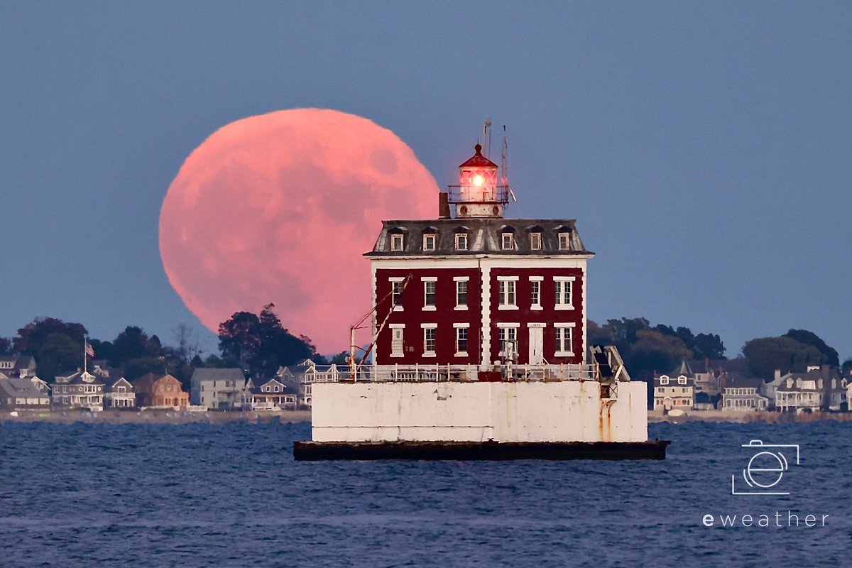
Another capture of the full #HuntersMoon rising behind Ledge Light in New London tonight! #ThePhotoHour
@thedayct
10
30
402
RT @joeyCTwx: Light snow falling in Tolland with a coating of new snow on the ground and trees so far

0
3
0

Close up on SNE. We need a nor’easter to fill the deficit!😊

Not only is it impressive that every single state has seen snow already this winter….but how about the fact that every single state has received at least 5” of snow this winter?! 😲 Wow. SC you were closest but hit the 5” mark in the NE part of the state.

4
1
39
Not only is it impressive that every single state has seen snow already this winter….but how about the fact that every single state has received at least 5” of snow this winter?! 😲 Wow. SC you were closest but hit the 5” mark in the NE part of the state.
8
25
193
@sdoppler2 It’s certainly felt more like winter this year than the last several even though there’s a snow deficit.
1
0
5
RT @jcaborn: @Eweather13 Good evening Eweather I have been getting light snow here in Staffordville. Things starting to get coated up temp…
0
1
0
Light snow has developed across parts of the area. Below is the latest HRRR model simulated radar. The time stamp is bottom left. Slick travel tonight. Pockets of light snow already around. After a coating (1-2” in the hills of central/western MA), it changes to an icy mix overnight from south to north and then to rain tomorrow morning near the coast and in the valleys - with ice lingering in the hills. A slick am commute in spots inland. School delays possible inland and maybe a few cancellations in the hills. Have a great night.
2
3
36
GFS is back with our snowstorm one week from tomorrow. Canadian is low and away. Lots of time here. Watching…


13
4
99
RT @Crazyplan9: About 1.8 in Groton, CT. Fluffy stuff, clears off car easy! @gilsimmons @NWSNewYorkNY @bobmaxon @RachelFrank_CT @bobmaxon @…
0
2
0
RT @Lclimateguy: 1.5 inches Madison ct nice little light snow @gilsimmons @Eweather13 @BradyBGWX @NWSNewYorkNY

0
3
0

RT @Crazyplan9: Groton, CT is an underrated snow town! So far this season, I’ve measured a total of 10.3”. All we need is one “big one” to…
0
3
0

This weekend looks messy! ⚠️Saturday: ☁️❄️ Mostly cloudy with snow developing during the afternoon. Highs in the 30s. ⚠️Saturday night: Snow transitions to rain at the coast, an icy mix inland. The icing may hang on for a bit in the hills. Temps slowly rise from south to north. ⚠️Sunday: 🌧️☁️🌬️ Rain, or ice in the hills changing to rain. Ice tries to hang on farther north in MA and across northern New England. Highs in the low to mid 40s, except 35-40° in the hills. Precipitation ends early Sunday night - possibly as mix/snow briefly as temps drop. Slick spots may develop.


2
2
54
Friday ❤️: 🌤️⛅️💨 Partly to mostly sunny with blustery NW winds and much colder. Highs 30-35°. Mid to upper 20s in the hills. The wind will make it feel much colder. Find someone to snuggle with!

0
1
15
Here’s a couple of model ideas of how things may play out tonight into tomorrow morning


⚠️ Tonight: Light snow develops with just a very light accumulation prior to changing to an icy mix and then rain along the south coast by daybreak. Lows 25-30° inland, low 30s along the shoreline. Temps slowly rise toward daybreak. ⚠️Thursday: 🌨️🌧️☁️⛅️ Rain along the shoreline with an icy mix inland transitioning briefly to rain before ending. The precipitation should be done around midday with partly sunny skies developing by late afternoon. A slick am commute expected inland. Highs break into the 40s across most of SNE - coastal areas across the SE may get well into the 40s.


0
1
21
Today: 🌥️☁️ Mostly cloudy. A few flurries scattered about. Highs in the 30s.

0
0
4