

T☈EY FULB☈IGHT
@CF3_Weather
Followers
2,739
Following
1,754
Media
12,825
Statuses
25,837
Christian | Meteorologist @KDKA | BS @iowastateu | Graduate student @MSStateGrads | Former NWS FWD Intern| Storm chaser, outdoorsman, cooking, & music!
Pennsylvania, USA
Joined October 2014
Don't wanna be here?
Send us removal request.
Explore trending content on Musk Viewer
LINGLING MAJOR FANDOM
• 609702 Tweets
Colorado
• 200231 Tweets
#انقاذ_النصر_مطلب_عشاقه
• 168038 Tweets
SAY SOMETHING
• 167615 Tweets
UEFA
• 66222 Tweets
Your Season On Stage
• 53140 Tweets
#UCLdraw
• 47601 Tweets
#ابعاد_لودي_مطلبنا
• 33825 Tweets
Narcisa
• 20300 Tweets
OUR AUGUST SUNSHINE KIM GYUVIN
• 19943 Tweets
台風どこ
• 18650 Tweets
Jabar
• 18250 Tweets
#HAPPYRIHITODAY
• 14470 Tweets
ハチャウマ
• 14029 Tweets
#松本潤誕生祭
• 11952 Tweets
#りーくん23歳_ヨロコビいっぱいでいて
• 11726 Tweets


Pinned Tweet

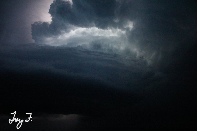
This is my close range view of the Minden, IA tornado at 5:43PM yesterday. We were on 360th a few miles east of town. Incredible violent motion at the base with debris being thrown out. Watch the collar cloud work its way down. Common characteristic of violent tornadoes.
#iawx
0
8
125
Tomorrow’s severe weather threat will be over one of the worst spots for radar coverage east of the Rockies. Lowest scan over parts of Northeast TX is ~10,000FT, which can be a problem when trying to detect shallow mesocyclones and QLCS-type tornadic circulations.
#txwx

30
134
574
It’s Wednesday, Sept 6 and there is no CAT 6 hurricane near
#flwx
.
Real Meteorologists: 1
CAT 6 Woman: 0

16
28
331
4 reasons Tuesday’s setup is more concerning than yesterday:
1.) Insanely favorable synoptics
2.) Deeper surface with very strong/backed low level flow
3.) Bigger, looping hodographs compared to the straighter ones we began with yesterday
4.) Higher dew points/more CAPE
#iawx
9
41
230
Powerflashes now in Aubrey! Looking north toward Pilot Pilot from HWY 377 and Spring Hill Road.
#txwx
#dfwwx
@NWSFortWorth
@RickMitchellWX
10
53
184
Very excited to become a full-time meteorologist at KCCI starting June 23. I’ve enjoyed filling in over the past year and getting to work with everyone at the station. Looking forward to much more to come!
#iawx

Not only does
@CF3_Weather
become a meteorologist this weekend - he is officially joining the
@kcci
Storm Team 8 weather team June 23rd! Central Iowa is incredibly lucky to have him. His severe weather skill set will prove to be invaluable.

4
3
68
39
7
218

Once again
@NWSFortWorth
did an excellent job forecasting the event and impacts of this week’s winter storm. This was the messaging in their forecast discussion ON FRIDAY.
#txwx
#dfwwx
#winterstorm
#poweroutages

4
43
203
Goodness! Tornado just went thru several Chicago suburbs. Naperville, Woodbridge, Darien are just a few the areas affected.
#ilwx
#chicagowx
9
68
201
Still trying to wrap my mind around how deep that vortex hole is. Not a BWER, a VORTEX HOLE. Notice how it doesn't tilt/shift much with increasing beam height. Nearly vertical through the storm. Extremely strong vertical motion with this.
#okwx
0
22
168
Biggest snowflakes I’ve ever seen. Snowflakes splatting in the middle of HWY 5 between Lovilia and Albia.
#iawx
11
12
165
Alright
#wxtwitter
which one of these NWS Watch/Warning maps is the most impressive in your opinion?
1. August 2023 Heat Wave
2. Feb 2021 Deep South Winter Storm
3. Feb 2021 Arctic Outbreak
4. Jan 2019 Midwest Arctic Outbreak
Vote/comment below!
#uswx


68
12
141
Honored and thankful to receive this reward!
The 2021 National Weather Association Foundation (
@nwafoundation1
) Broadcast Meteorology Scholarship is awarded to Trey Fulbright (
@CF3_Weather
) from Iowa State University. 👏

3
0
23
25
4
135
Large bowl shaped wall cloud 12.8mi S of Henrietta on HWY 148. Cell is recycling. New tornado imminent.
#okwx
#txwx
@NWSNorman
@NWSFortWorth
3
31
121
This is horrifying satellite imagery. Multiple counties in the Texas Panhandle on fire tonight due to dry/windy conditions. Originally, winds were strong out of the west dow sloping off the higher terrain and heating up/drying out. Cold front blew through and kicked up…
#txwx
4
28
118


After living, traveling, and or chasing in different tornado hot spots in the US, this is what I came up with. Green=great, yellow=okay or proceed w/caution; Red=not good.
#wxtwitter
What do y’all think?
#stormchase


14
7
113
Wow! 185MPH gate to gate shear with this tornado. Very wide debris ball. Likely a violent tornado ongoing northeast of Damascus, GA.


4
30
107
Thankful for the opportunity to fill in at
@KCCINews
over the next few weeks. Getting trained with
@JSydejkoKCCI
this weekend!
#iawx

15
3
107
[1] The first potentially major trough of this series will eject into the Central US this Thursday & Friday. There are and have been well pronounced difference in trough shape, tilt, and strength between the GFS & ECMWF. GFS favors a neutral-tilt, bowling ball w/ stronger...
#iawx

2
10
106
The Columbia Pictures title card is a high CAPE, low shear environment FYI…

4
5
108
When comparing the visual structure of the
#Greenfield
tornado, I see resemblances of Heston 1990 and Andover 1991. Solid thick cone/stove pipe (never wedged out); Violent upward motion along the outer edges. Heston really stands out, except much lower precip environment.
#iawx


4
7
106
Chasers—share your top “Oh snap!” radar images from chases you’ve been on this year.
#wxtwitter
#stormchase


38
4
103

4
29
96
The National Weather Service is on top of all of these tornado warnings tonight. But this event is screaming that all radar gaps need to be covered ASAP in tornado prone regions east of the Rockies!
2
19
103
Who’s ready for mega trough, speed of light jet streak, and bomb cyclone season?
#wxtwitter
#wxX


9
5
102


FRIDAY SEVERE RISK:
1). AM convection likely
2.) Break midday-early PM as mid-level dry slot wraps in from SW. Leads to some clearing, heating, & steeper MLLRs as moisture advection continues from south.
3.) Areas to watch: TP into warm sector; sfc low/occluded boundary...
#iawx

3
9
95
Increasing concern that storm mode may initially favor discrete supercells tomorrow along an arcing dry line. With the dry line arcing back and 0-6km shear vectors at an angle to the initiating boundary, storms that erupt will be less inclined to “run” into each other.
#txwx


3
17
90
Sheesh 117mph toward, 141mph away. 257 mph gate to gate shear 600FT off the ground; 128.5mph VROT. Absurd!
#okwx


3
14
92


Yesterday’s severe weather event was not a “bust” as that would imply no severe weather occurred at all. The tornado-driven high risk area greatly underperformed, however, the hail and especially wind damage areas verified well. Note some of the wind damage may be QLCS tornado…

6
11
87
[1] SEVERE WEATHER THREAT 4.04.2023 (THREAD)
There will be three primary zones to monitor for severe storm development tomorrow. The thread below will break down the synoptics, environment, and uncertainties in each area:
#iawx

4
15
87
1925 TRI-STATE v DEC 10, 2021 TORNADO ENVIRONMENTS...
[1] 500mb: Both days featured a fairly broad, slightly positively tilted trough with strong divergence/diffluence east of the trough axis. 2021 had stronger flow from phasing of STJ & more amplitude to the trough.
#wxhistory


1
9
85
Two years ago tonight, I was reviewing for my Synoptic Meteorology final and watching water vapor imagery in awe at the shortwave trough moving through the Rockies knowing the next day was going to be crazy. Then SPC issued the farthest north December moderate risk at 06z…
#iawx


2
2
82
HWY 4 near Palo Alto/ Pocahontas Line: Just had an 18 Wheeler spin out in front of us as the leading edge of the derecho passed over. Dangerous storms!
#iawx
@NWSDesMoines
@KCCINews
4
26
82
As bad as May 21, 2024 in
#iawx
was, this tornado outbreak would've been much worse had storm mode favored more discrete supercells and less mergers & upscale growth. Here are some of the factors that led to the storm mode from the day:

4
16
80
[1] Threat for significant severe weather is INCREASING on Friday across Central and Eastern Iowa. Models have slowed down with the overall forward progression of the synoptic storm system and have all trended toward a deeper, closed off storm system with stronger flow…
#iawx


3
7
79
Wall cloud with a little lowering scud beneath it. 4 miles west of Bloomfield.
#iawx
@NWSDesMoines
3
19
80
So glad I came to Iowa State to pursue a degree in meteorology. Thankful for all the professors who instructed and guided us and the wonderful friendships made along the way!
#cycloneforever
#cyclonepower
#isu
#iawx


4
1
80


2
6
79
I guess tonight is the equivalent of “wait until the LLJ kicks in” with storm chasing.
#AuroraBorealis
7
3
77

Loaded gun sounding from FWD. Very strong low level winds and low level shear. Critical angle a little small in DFW, but even better, more streamwise hodographs from Dallas and points east. Very dangerous setup.
#txwx

2
21
78
3
24
77
Severe storms are increasingly likely late Sunday evening into Sunday night as a second, stronger upper level disturbance tracks over the state. Strong instability and strong deep layer shear will support supercells with a large hail threat. Damaging winds becoming likely…


4
10
75
Cell NW of Oskaloosa looking more supercellular. Little bit of RFD starting surge, ragged wall cloud, increasing lightning.
#iawx
0
17
75
Newest HRRR/3km NAM trending higher with low level moisture (mid 60s dews) and a more unstable environment (indicated by more negative LIs) co-located with moisture plume. Dry line mixes well into SW Iowa tomorrow. Volatile setup pending the timing of convective waves.
#iawx


5
7
76


What’s your best tornado shot of the year? Here’s mine.

29
11
132
2
2
75
We ran into
@BrandonCopicWx
and Storm Seeker # 3 while out today. Fun day considering a long chasing drought!

0
3
74
Sitting on HWY 377 in Aubrey looking north into the circulation. Striation associated with leading edge of mesocyclone passing north of us. Cannot make anything else out.
#dfwwx
#txwx
@NWSFortWorth
2
13
72
18z HRRR coming in with a slower progression & slightly farther westward alignment of the jet streak and low level jet tomorrow. Surface features also farther west with a considerable increase of instability. Watch this trend closely as it could mean bigger problems...
#iawx
1
9
73
Where was this pattern around May 15-30 when I blocked out time to literally drive up and down the Great Plains? 🙃

5
2
69
Y'all this isn't just a supercell....This is a Colorado Super DUPER Cell. Free handed these with my DSLR Wednesday night between Lamar and Two Buttes, CO.
#cowx
#stormchase


0
9
70
Here’s my video from just north of Lennox on Sycamore Ave (Old HWY 49) according to Google Maps with added contrast since I forgot to roll down windows. Time was 7:21PM.
#iawx
@NWSDesMoines
4
14
65
Growing potential for a significant severe weather threat next Monday afternoon & possibly Tuesday. Begins Monday in Western Iowa/Eastern Nebraska. Models have been very consistent with a powerhouse trough taking on a negative tilt (leans back rearward)
#iawx
…


2
10
68

FRI SEVERE THREAT:
Severe storms are likely in the outlined area Friday afternoon-evening. Models getting in range and show a plume of low-mid 60s dews advecting north w/ strongly sheared warm sector into a low that reaches maturity over NE before occluding mid afternoon.
#iawx

4
3
67
This hook has a perfect spiral. Wow! RFD is surging at just the right rate to not force a complete occlusion!
#kswx

3
12
64
Large tornado on 240th street about 5 miles east of Williamsburg, IA. Time stamp was 2:06PM.
#iawx
1
18
64


Forecast soundings from the HRRR/3km NAM taken near Ottumwa by 4-5pm today. This is where the environment will be supportive of significant severe weather.
#iawx


10
6
65
0
20
62
First time assisting with in-studio tornado coverage yesterday with
@ChrisGWxKCCI
. The last several months have been very busy with for severe weather in Iowa including two very unusual cool season events—December 15, 2021 and March 5, 2022.
#iawx
7
0
64


Basic or general meteorology should be a required course in the public school system. Every person, every age, every income gap, every career, in some form or fashion is impacted by weather and a changing climate!

Why does it seem like the general public is getting less and less informed, educated and mindful of severe weather events despite so much advancement in technology and wide access to weather information?
I feels like people in the 80's and 90's would have been better informed.
30
13
172
3
8
60


[1] Overnight models continue to show a very dynamic neutral/negatively tilted shortwave coming up late Friday-Sunday lifting north from the Southern Plains into the mid-Mississippi Valley. This system *could* impact southeast 1/2 of IA depending on how progressive…
#iawx


2
9
58
Significant tornado damage in Story county from east of Cambridge to northeast of Nevada.
#iawx


0
7
59

Had the opportunity and privilege to meet Dr. Greg Forbes at
@CentralIowaNWA
conference! Forbes gave two amazing talks on how disaster prone we are today despite improved communication/predictability and 1974 Super Outbreak. I grew up watching Forbes on
@weatherchannel
.
#iawx

3
1
60


4
21
56
SEVERE STORMS LIKELY FRIDAY-FRIDAY NIGHT…
[1] As the upper high begins to contract, this will allow a shortwave trough to drive a cold front south. 90° temps, 75-80° dews, and steep lapse rates will yield anywhere from 3000-5500+ CAPE over Central & Northern IA…
#iawx


4
10
59
Let’s really hope this doesn’t come to fruition. This would result in some of the worst heat we’ve seen all summer and quite frankly in several years. 😬
#iawx


1
4
58
[1] Tuesday continues to have a very substantial severe weather look for Central-Eastern IA, Western IL, northern MO. Neutral-negatively tilted shortwave with jet max arriving at peak heating. Jet max overspreading the warm sector with strong height falls, a...
#iawx


2
10
58


Hodographs in the next few hours would be textbook for tornadic supercells and strong tornadoes. But we are also missing the ‘M’ in SLIM—our acronym for severe storm forecasting, and that is moisture. Tornadoes are a fine process where all ingredients are necessary.
#iawx

0
6
56
Holy moly! RFD push gave this circulation and extra bump! Significant tornado in SW Oklahoma!
#okwx
0
11
56
Cyclic supercell that produced a violent tornado in
#Matador
, TX still hauling south into very moist/unstable air mass in West Texas. Mesocyclone looks to be on the upswing with a well-defined hook echo and strong tornado vortex signature on velocity just southeast of Jayton.
2
12
56
Tornado and ice? Yes! Those are the remnants of snow drifts that compacted into ice in the ditches from the pre-Christmas blizzard. Saw this yesterday as we were traveling north toward I-80 from Williamsburg.
#iawx

0
6
56