Steve LaPointe
@CBS6Steve
Followers
4,376
Following
558
Media
12,574
Statuses
16,322
I'm the Chief Meteorologist at CBS6 - WRGB, Albany, Schenectady, Troy, NY, Penn State grad, native New Englander and long time weather nut.
Niskayuna, NY
Joined December 2011
Don't wanna be here?
Send us removal request.
Explore trending content on Musk Viewer
Jets
• 103521 Tweets
Patriots
• 103473 Tweets
Wanni
• 97729 Tweets
Bills
• 95099 Tweets
Onyeka
• 91588 Tweets
Ravens
• 68849 Tweets
Semih
• 68612 Tweets
#خادم_الحرمين_الشريفين
• 64355 Tweets
#الملك_سلمان_بن_عبدالعزيز
• 63497 Tweets
Lamar
• 60089 Tweets
Bengals
• 58452 Tweets
Browns
• 51950 Tweets
Penaltı
• 48664 Tweets
Spurs
• 45468 Tweets
Watson
• 42359 Tweets
Hoca
• 39698 Tweets
Texans
• 32170 Tweets
Panthers
• 32103 Tweets
Caleb
• 28777 Tweets
Colts
• 27179 Tweets
Burrow
• 25396 Tweets
Buffalo
• 20274 Tweets
Jaguars
• 19691 Tweets
#BBUK
• 18704 Tweets
Jayden Daniels
• 17660 Tweets
Congratulations Kellyrae
• 15480 Tweets
Derrick Henry
• 14762 Tweets
Josh Allen
• 13548 Tweets
Pats
• 11726 Tweets
#سلامتك_يابوفهد
• 11479 Tweets


The most snow I’ve ever seen at my place, preliminary measurement of 32”

12
15
184
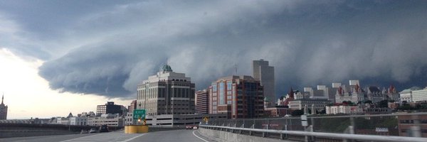
Awesome shot from CBS6 viewer Debbie Dominic Lamay of cloud to ground lightning behind a shelf cloud as it was passing over Saratoga Lake this evening.

1
5
92
That’s my driveway but that’s not snow covering it. It’s 2.0” of concrete consistency sleet compacted into an immovable sheet of joy.
#sleetbomb

9
5
74


Wishing all the best to one of the greatest and a local icon
@BobKovachick
as he signs off today from a long, successful, and prestigious career at WNYT News Channel 13. Enjoy your much deserved retirement.
3
4
74
I mean, it's upstate NY and it does snow in the winter...but apparently there's actually been a run on bread and milk...the shelves at one local grocery store early this evening, just wow! People are funny
#itsjustsnow

13
3
71
How did we not promote this today? Rudolph’s on Channel 6 right now

10
3
65
Sidelined the past couple of days by Covid. Yup it finally got me, but I’m triple vaccinated and doing well. The plan is to be back in the forecast chair on Monday, Tuesday at the latest

11
0
66
It's a blast from the past
@kellycass
. Old pictures recently found in a desk at the station in an envelop labeled March. I believe these were taken in March 1993...many lifetimes ago.


7
0
67
May or March? This is the scene this morning on top of the mountain in Woodford, VT, Bennington County (Elevation: 2300') 3.5" of heavy wet snow - Photo Credit: WeatherNet 6 spotter Betty Roark.

2
25
62
Air quality over much of the area has spiked to CODE RED, just plain unhealthy...this due to near surface soot and particulate matter originating from the wildfires in Quebec. If possible, limit outside exposure, keep the windows in your house closed for now.

7
32
62
Be excited, we just had our first two consecutive day run of dry weather since June 26-27th. Woot! It's all about the little things :-)
0
6
60
More from
@kellycass
in our blizzard of '93 coverage Saturday evening March 13, 1993, thirty years ago.
1
1
58

2nd Pfizer Covid-19 vaccine shot this morning. I did it for me and for everyone around me. Together we can collectively beat back Covid.
#CovidVaccine

2
1
57
Weather posts on facebook, 10 likes, 5 comments - Christmas cactus goes viral 🤦♂️

2
1
54
Increasing concern for a significant severe weather threat developing Thursday, mid morning to mid afternoon would be the time frame locally. Fine details are not clear yet and those are critical. This is an early heads up.

2
9
52
Snowfall amount and distribution map made possible by the huge number of WeatherNet 6 spotter reports. Narrow mega snow band with 3"-4"/hour snowfall rates did this. There's a lot of "Wow" here

6
9
50
Ring of fire bonfires now lighting up the shores of the Great Sacandaga Lake

0
4
49

It's a rainbow evening, spectacular double here from Fonda

2
13
48
You might disagree and report me to the fashion police, but when it's 70° in November, wearing a white jacket is okay in my book. :-)

5
2
47
Stunning shot of the moon not long ago from Boght Corners - Sean Organ

2
10
47
Total geek out morning at the Albany airport touring the planes and speaking with the amazing hurricane hunter and noaa research crews on their hurricane preparedness tour stop in the capital region. Sam will have the full story tomorrow on CBS6.


4
2
47
Quite the get here from a storm in E. Meredith, Delaware County this evening: Photographer: Alex Pool
#NYwx

0
3
46


Ground reports plus a radar correlation supports this as the general "Sleet Bomb" zone that has left a 2-3" thick layer of concrete awfulness that many of us will be stuck with for several days. Very unique to get so much sleet over such a long duration.

1
6
45
The Aurora from Red Hook, NY, Dutchess County March 17, 2015: Photographer: Elisa Shaw, Thank you Elisa for sharing
http://t.co/AKajca0blM

0
52
41

I'm wearing the same suit today, that I wore then, 26 years later

This was
@CBS6Steve
26 years ago today, reporting on the massive March '93 blizzard. Right after this he celebrated his 15th birthday 😄

4
3
65
4
1
43
The smoke is coming back later tomorrow and Friday...not like last week though when it was close to the ground. This is elevated smoke, so hazy skies likely but air quality issues should be minimal. It's going to be a long summer of smoky episodes.

5
9
43

Threatening comment on a facebook post I made today where I referenced a local impact of climate change. Social media behavior by some is truly concerning.

16
2
44
It’s been a banner summer for hydrangeas. This one in my yard typically never blooms. This year it’s a bonanza


2
1
40
Sean Organ capturing what may have been a brief little landspout in Ballston Spa along the leading edge of a cell running along a frontal triple point, weakening meso-low. Same cell that produced wind and flooding in Montgomery County earlier
#nywx


3
8
42
Here's something, tonight's sunset at Albany is 4:21pm. Tomorrow's sunset is 4:22pm. The slow road to gaining more daylight in the afternoons is about to begin.
2
12
40
Closing in on a week after the sleet storm and I’ve finally got a beachhead in the driveway…the battle continues

8
0
42
Perfect timing for the clouds to thin producing this spectacular sky over Niskayuna

4
3
41

Clifton Park, 6:26pm, after the gloom a brief blast of color

2
5
40
I would not be putting the shovels and the snowblowers away this weekend....we're not done yet. Next week's storm looks large, long duration, and cold. All areas may be in line for at least some snow with it.

11
5
39
Back in Oak Bluffs, 10:45 am, wind here is up and the splash over onto Beach Rd more significant now
#henri
3
14
40

Jack Aernecke with a look at the "Storm of the Century" impacts across the country - part of the special NewsCenter 6 coverage that Saturday evening March 13, 1993 - 30 years ago
1
7
39
Worst air quality I've ever seen locally now in the western Catskills, Mohawk valley, and Capital Region, CODE PURPLE, Very Unhealthy. Limit time outdoors, keep windows closed

5
14
39
Impressive mammatus cloud display over Central Avenue in Albany, right around 5:15pm - Jason Cross

0
12
33
Here’s the preliminary shake map from the USGS, this will be updated as more reports of feeling it come in

2
16
36

Albany buildings are illuminated in purple this evening in honor of Queen Elizabeth II

1
5
35
Racing the cold front as driveway reclamation efforts continue. This stuff goes solid again tonight. Get it done now

5
2
36
71 degrees at 9pm at Albany on November 5. That’s something!
3
4
34
In case you haven't heard, the senate passed a bill today making daylight saving time all year round. It's got to get through the house and then get signed for it to become law. But if it does, the sunrise in the winter gets pretty late for us.

5
8
35
I will declare, and I'm sure someone will dissent beacause that's the Internet, but today is about as close to a perfect June weather day that can be. So it has been said, so it shall be written. :-)

4
0
33
You know it’s pretty and all, but last Saturday morning when it was 70 degrees with dewpoints in the mid 60s at 1am…yeah I vote for that 😎

2
1
34
The Empire State Plaza among many of New York's landmark structures are currently lit up in support of Ukraine.

2
5
34


Joining meteorologists from around the world today
#MetsUnite
showing these global temperature stripes illustrating the drastic warming that’s now taking place
#ShowYourStripes

1
3
32
On this National Weather Person's Day, I, and my colleagues on the CBS6 weather team, would like to thank you for watching and putting your trust in us.
@CBS6Alyssa
@CBS6CraigAdams
@CraigGoldCBS6
#NationalWeatherPersonDay
#AMS100

2
3
32
One of what were many many severe weather cut-ins back on this date in 1998 when the severe weather outbreak that produced the Mechanicvill-Stillwater tornado. This was just before the tornado touched down. More clips here:
2
0
32
It's
#ShowYourStripes
day, the 4th annual, where the global meteorological community comes together to raise awareness of climate change and the increasing impacts from it.
#COP26
#climatematters


1
7
31
No shorts, but the T-shirt works right now. Taking a walk in the woods enjoying the 60s. Take advantage if you can, rain and 40s on the way for Monday
#fakespring

2
2
29

I’m not quite there yet, but another week without a haircut and things are going to get ugly. You think WRGB will let me buzz it?

9
0
30
35 years it ago, it snowed a lot...heavy, wet, and destructive. This analysis by Finch in 2010 gives us a good idea of the distribution of the snowfall from the event.

0
5
29
Looking at the tstorm that’s near Albany, from Niskayuna, beautiful lighting

2
3
27


The tie means something today.
#ShowYourStripes
Day. Happy to join with colleagues around the world again this year to spread awareness about human induced climate change and to educate and inform
@ClimateCentral

4
3
31
It’s faint, but look close, it’s a neighborhood level rainbow, or mistbow in this case as a drizzle created it. This is a larger scale of what a garden hose can produce and overall really cool


1
4
30
Wrapping up a very successful and informative 51st conference on broadcast meteorology in Myrtle Beach. A few of you may recognize John Cessarich, who preceded me at WRGB. Chuck Bell, from NBC Washington in the photo. And Kelvin Helmholtz clouds just for fun. Back in on Monday


3
0
30
We just came through the 3rd warmest winter on record at Albany (looking at the airport climate site only) with the top five warmest all since the 2001-02 winter. Yes, that's climate change.

4
9
30
Catching the tail end of the prettiest snow of the season here at the station

2
2
28
Another looks at the Doppler rainfall estimates which are matching very closely to ground truth observations. So much water, so fast. Most of this fell within about 2 hours.

4
4
29

With former WRGB meteorologists and good friends Chris Gloninger and Mike Augustyniak at the AMS Broadcast Conference

2
1
29

Because it’s March, and not January, we’re getting a lot more solar energy through the clouds, so even with some heavier snow bands coming through the driveway remains just wet, not white

4
5
28
The aftermath of what happened 36 years ago today. By the way, today's record high at Albany is 86° and we've got a strong shot.

0
6
29
This is the worst air quality and near surface smoke event since July 20, 2021. The view looking southeast from the Corning Tower in Albany...a Martian-like look to the atmosphere. - Jim Reidy Jr.

6
10
28
Storm track uncertainty remains with the inbound...but I'm leaning toward a colder and snowier solution for much of our area with major snow accums. increasingly likely west of the Hudson valley and in VT, possible in the Capital Region. Tough travel conditions likely.

2
7
29
Looking ahead to early next week, signals are strong for a major slow moving nor'easter...track governs local impacts. But we're in a "Heads Up" mode now for the potential of a lot of wet damaging snow, some rain, and wind.


6
6
29


Look at this, a post Isaias rainbow here in Niskayuna. What a day today!

1
2
28
Huge quarter and half dollar sized snowflakes in Clifton Park around 5:30pm
1
2
29

I’ll be commissioning a geologic survey of the sleet strata since it won’t be going anywhere anytime soon.
#sleetbomb

3
3
28
High impact long duration storm with widespread heavy wet damaging snow likely...power outage potential will be high with this. Heaviest is Monday night into Tuesday, strong gusts later Tuesday into Wednesday. Expect difficult travel especially in the higher elevations.


0
8
28

My confidence is growing for an excessive rain event to unfold locally later Sun, Sun. night and/or into Mon.which could amount to some areas getting 4-5" of rainfall with a renewed flooding threat. Timing and location details yet to be worked out so stay informed this weekend.

2
6
28
There’s a coating of snow right now in Clifton Park on May 9, and it’s not melting. Whoever is playing Jumanji needs to stop now, I mean really!

2
4
25