

Bunting Labs 🗺
@BuntingLabs
Followers
1K
Following
189
Statuses
184
bringing AI to GIS. we built an AI vectorizer (raster + survey plats) and an AI georeferencer.
37.757, -122.472
Joined April 2022
🗺️ Our AI #GIS assistant Kue can now handle multi-step reasoning! You can ask it to do two geoprocessing steps and it will break it down and run them sequentially. If you want to try it out go to the QGIS manage and install plugins window and search for Kue!
2
24
118
0
5
0
RT @MichaelEBunting: To make Kue—our AI GIS assistant—more user friendly we've translated it into 21 new languages! Now, Kue uses your QGIS…
0
12
0
RT @normconstant: In QGIS it's hard to get geoprocessing right the first time, if it's even possible to do it in just one step. Now, Kue c…
0
31
0
RT @hansakwast: New Video: Exploring the Kue plugin: an #AI Chatbot for #QGIS by @BuntingLabs 🌍✨ Simplify geoprocessing tasks with AI. Hig…
0
10
0
RT @MichaelEBunting: You can now add #OpenStreetMap data to your QGIS project with AI! With Kue v 1.7, you can ask for any OSM feature in…
0
31
0
RT @MichaelEBunting: 🗺️ How LLMs will change #GIS: working with GIS will become something easily accessible to anyone who wants to get star…
0
22
0
RT @normconstant: Can AI complete a college-level Iowa State GIS homework assignment? 🤯 @MichaelEBunting puts Kue, our new QGIS plugin, to…
0
3
0
RT @normconstant: Kue was my tool for day 13 of the #30DayMapChallenge. I wanted to visualize which california parks I'd see only one type…
0
9
0
RT @normconstant: Today we're launching Kue, an AI assistant inside QGIS. Kue can edit your project by styling layers, filtering with SQL,…
0
96
0
0
0
0
RT @normconstant: The AI Georeferencer in QGIS is now publicly available 1. Aerial imagery georeferences to satellite near the QGIS map ca…
0
136
0
@MichaelEBunting If you want to try out the new legal description converter on our website go to:
0
0
0
RT @MichaelEBunting: Our AI legal description plotter has three new tools for verifying accuracy! Now, you can see the created geometry,…
0
5
0
RT @franzpc: Digitalizar automáticamente curvas de nivel o ríos y polígonos en QGIS, usando Inteligencia Artificial @BuntingLabs
https://t.…
0
171
0
RT @MichaelEBunting: Our #QGIS AI Land Description digitizer lets you map legal descriptions in under 20 seconds! Just click on your point…
0
39
0
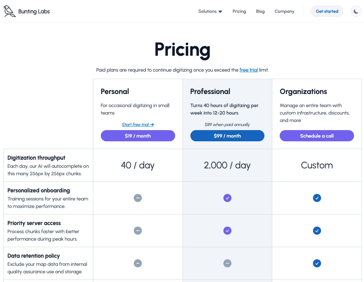
We've created a less expensive Personal tier of 40 chunks per day at $19/month for people who only do occasional digitizing! This is equivalent to about 30 minutes of manual digitization per day. If you have any questions, send us a DM
0
0
7