

Andrew Adams
@AAdamsWX
Followers
3K
Following
78K
Statuses
21K
Meteorologist @NEWS9 | Former @ABC7SWFL | FWTX Native | Boomer Sooner | Sometimes I talk about sports | views are my own
Oklahoma City, OK
Joined September 2016


He's got to have other admins on his twitter account. This is pretty insane.

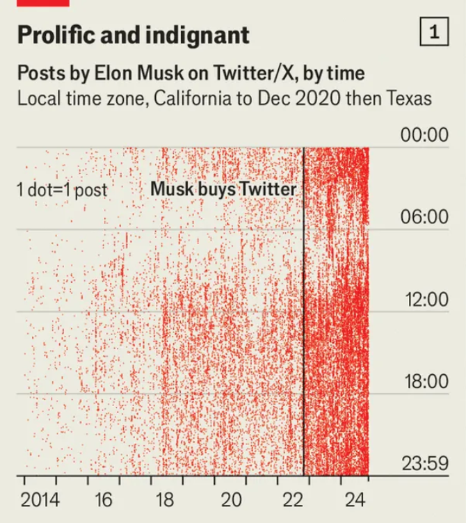
@jessesingal I think he's legitimately cooked — this little sleep compounded over years, let alone weeks, severely impacts cognition and decision making.
0
0
1
RT @quantian1: Is this a bit? Do you not think there is an OBVIOUS reason why the government might keep many important records on paper in…
0
2K
0
RT @DrNeilStone: Incredibly, some people still think that ventilators killed people, not Covid Its like saying that someone died because…
0
268
0
Plenty of slippery roads this morning thanks to snow, sleet, and ice overnight! Once the sun comes up today, roads will improve some, but with highs staying below freezing, slick spots remain in places through tomorrow morning. If you have to go out, drive safe! #okwx


0
7
21


Tonight's system brings rain, freezing rain, sleet, and snow to the state. This will make for slick and hazardous road conditions by tomorrow morning for many Oklahoman's. A narrow corridor of higher ice and sleet totals will be the focus for the worst road contitions. #okwx


1
12
45
We are winning the World Series

The anticipated the starting lineup for the 2025 Texas Rangers (via MLB) is: 1. Marcus Semine, 2B 2. Corey Seager, SS 3. Wyatt Langford, LF 4. Adolis Garcia, RF 5. Joc Pederson, DH 6. Josh Jung, 3B 7. Jake Burger, 1B 8. Jonah Heim, C 9. Evan Carter, CF

0
0
1


RT @DHuskytron: I remember I called it a digital lobotomy early last year. And now, well, there it is.
0
13K
0
I get more from answering Nielsen surveys (711mil/300mil is just over 2 dollars per person lol)

BREAKING: Elon Musk calls for the Consumer Financial Protection Bureau (CFPB) remaining account balance of $711,586,678.00 to be returned to the American taxpayers.
0
0
2
As they should.

1
0
1
Ruined a franchise in one move

You can almost just look at a fan section and if you wait long enough, a fan gets removed.
1
0
3

It's been almost 2 years since the name change and still links to "X" in case anyone was wondering. Love it. 😂
0
0
0


