
Mount Washington Observatory (MWO)
@MWObs
Followers
33,164
Following
255
Media
3,163
Statuses
5,654
Mount Washington Observatory is a non-profit institution working to advance understanding of the natural systems that create the Earth's weather and climate.
Mount Washington, NH
Joined October 2010
Don't wanna be here?
Send us removal request.
Explore trending content on Musk Viewer
Fenerbahçe
• 285393 Tweets
#الاتحاد_الهلال
• 74028 Tweets
Palace
• 64152 Tweets
#FBvsGS
• 57962 Tweets
Martinez
• 44871 Tweets
Ohio State
• 32235 Tweets
Okan
• 32182 Tweets
Ten Hag
• 30777 Tweets
I.N AT BOTTEGA VENETA MFW
• 27956 Tweets
Penaltı
• 26904 Tweets
#CRYMUN
• 26065 Tweets
Yunus
• 23137 Tweets
Mourinho
• 23103 Tweets
Rashford
• 22945 Tweets
Kaan
• 22298 Tweets
Garnacho
• 20642 Tweets
Hakem
• 20084 Tweets
Dzeko
• 19088 Tweets
Mertens
• 18324 Tweets
Zirkzee
• 17335 Tweets
Henderson
• 17239 Tweets
نيفيز
• 17189 Tweets
Marshall
• 17071 Tweets
İsmail
• 16541 Tweets
Tadic
• 15242 Tweets
Onana
• 14314 Tweets
Ali Koç
• 13141 Tweets
العمري
• 12614 Tweets
Amad
• 11969 Tweets
Faul
• 11962 Tweets
İrfan
• 11768 Tweets
Eriksen
• 11278 Tweets
NC State
• 10969 Tweets


Pinned Tweet

Exclusive Product Release: MWOBS Snowcat Shirt! 🏔
Shop this returning fan favorite for a limited time only: Proceeds from this campaign will make it more affordable for NH students to experience the “Home of the World’s Worst Weather.”

1
7
30
These
@MWObs
scientists staffed our weather station through 13 hours of -45° F temps and 15 hours of wind chills below -100° F this weekend: Observers Alexis George and Francis Tarasiewicz, with Summit Intern Karl Philippoff. Consider supporting our work:

31
198
2K
Missed the totality path by that much🤏 Our location still had great views of a partial eclipse with 99.97% of the sun obscured. While we remained in the light, the shadow of totality can be seen extending to the right of the frame as it passed through northern VT/NH.
#eclipse
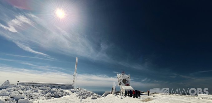
21
227
2K
One of our Observers found an area out of the 65+ mph winds this morning and was going to have some leftover spaghetti for breakfast at
#sunrise
but the -30F (-34C) temperatures prevented them from even taking a bite.
Our Higher Summits Forecast:

58
502
2K
The Northern Lights (Aurora Borealis) is currently visible from the summit as of 2030 EST. We have also seen images from central NH and northern ME.
#NH
#NHwx
#northernlights
#AuroraBorealis
#night

11
279
1K
Weather Observer Nicole Tallman heading outside to take a weather observation during today's high wind event! In this video conditions were -11 degrees with winds sustained at 115 gusting to 132!
So far (as of 7AM EST) our peak gust is 157 mph!
66
339
1K
A timelapse (8x speed) of today's
#SolarEclipse
from Mount Washington Observatory,
#NH
. It was a partial eclipse for our location w/ 99.97% coverage. Winds were 35-50 mph at the time, so keeping our camera setup stable was a bit of a challenge, so we apologize for the wobble.
21
180
1K
18" of snow and counting! 6 foot drifts in places and we just shoveled out the truck 30 minutes before this...😕
#snow
#nhwx
#MountWashington
#October
#WinterIsHere
56
417
1K
Our daily record low of -32F (set in 1963) has already been broken and is expected to plunge even lower overnight. You can track how low ambient air temperatures go on our Current Summit Conditions page:
Or view the weather live at:

41
286
1K
It's been done before, but always cool to see! Boiling water to snow in hurricane force winds with a temp of -31°F! Wind chill was -84°F.
#coldweather
#science
#mountwashington
#windy
29
531
973
The summit was treated to a vivid sunrise this morning. This comes after yesterday’s active weather which featured a record high temperature, thunderstorms, and a full gamut of wintry precipitation. The last 24 hours have shown that weather in the Whites can change quickly!

9
107
992
Around 12 AM this morning, the summit crew
got a chance to view the Northern Lights for a while. For this shift currently on duty, it was everyone's first time viewing them in person.
#aurbo
#auroraborealis
#northernlights
#solarstorm
#lightpillars
#northpole
#whitemountains


17
152
932
It's off the charts! Incredible wind storm ongoing this morning, with a peak gust of 148 mph the highest in over a decade!
#category4
#windy
#mwobs
#mountwashington
#presidentialrange

47
373
889
The sun has set on Marty's time here at the Observatory. It is with great sadness we announce the passing of Marty the Cat. There just aren't enough words
#mwobs
#martythecat
#martykitty
#love
#companion
#mwsp
#memberofthestaff
#seniority
#lastsunset
#nh
#caturday

121
101
891
This morning at approximately 3:02 EDT, this video footage was captured by the observatory's tower camera. What appears to be a fireball, or an especially bright meteor, streaked across the night sky as it moved from south to north.
#fireball
#meteor
#nightsky
#shootingstar
21
154
852
Winter bared its teeth and beauty this morning behind a strong cold front.
#rimeice
#winterweather
#mwobs
#nhwx
#ice
#mountainweather
#mtwashington
#whitemountains
#winteriscoming
#icecrystals
#winterwonderland


18
143
827
26
415
786


Mother Nature waved back this morning! A KH-lenticular, or Kelvin-Helmholtz wave cloud was spotted around 7 AM. These form when a large increase in winds occurs over a small vertical distance within a cloud.
#khcloud
#lenticular
#coolclouds
#mwobs
#nhwx
…

25
207
764
What an interesting morning we're having! A lenticular cloud gives way to a cap cloud overhead in this time lapse, with more snow, fog, and high winds for this evening.
#nhwx
#mtwashington
#lenticular
#clouds
#capcloud
16
174
742
We have some pretty fantastic lenticular clouds forming over the summit right now!
#mountwashington
#mountwashingtonobservatory
#mountainweather
#weather
#nature
#bluesky
#clouds
#lenticular
#science
#breathtaking

21
184
718

Winds were gusting well in excess of 100 mph this morning so we had to go outside and play! Flag used to help visualize the wind.
#HighWinds
24
413
698
At sunrise this morning, the summit was experiencing undercast conditions. Westerly winds pushed these clouds up and over the northern summits before descending into Great Gulf and then experiencing a hydraulic jump, similar to water flowing over rocks just below the water level.
9
127
679
Time-lapse of the aurora as seen from the summit earlier this morning. The lights on the right side correspond to Berlin, NH and the lights on the left side correspond to Lancaster, NH. The center of the video corresponds to roughly due north.
6
150
678
Fog has thinned enough to allow moonlight to pass through, resulting in the formation of a lunar fogbow. In the two pictures, you can see the lunar
#fogbow
over our instrument tower with Jupiter shining brightly above and another angle of it as viewed from our instrument tower.


10
117
650

The summit saw its first measurable snowfall of
the season today, with 0.3" of snow measured so far.
Below-freezing temperatures, high winds, and fog have also resulted in rime ice for most of the day.
Temperatures aren't expected to rise above freezing
until the end of the week.


9
123
622
We had a brief view of the
#northernlights
overnight prior to them fading as the "viewing oval" shifted westward (some impressive pics coming in from Iowa, SD, MN, MI, Canada, and Alaska so far). In this pic,... (1/x)

12
113
612
The skies on the leeward side of the White Mountains this morning are full of stacked lenticular clouds. It made for some dramatic looking skies to say the least. Lastly, good luck to all the runners this morning participating in the Mount Washington R…

12
143
594
Blizzard conditions on the summit this evening! Winds were sustained around 85 mph with gusts to 110 mph! All the snow that fell with this last storm is being blown into the ravines.
#Blizzard
#poorvisibility
#thisisawesome
20
179
590
The summits have finally emerged from the clouds after a nearly week-long stretch of freezing fog and near-zero visibility. Sunshine this morning revealed a thick coating of rime ice and 4.5 inches of new snowfall resulting from the extended period of wintry weather.


6
103
601
The first measurable snow fell this morning with on and off snow showers continuing into the early evening hours. We have been outside enjoying the first real taste of winter up here!


23
197
575
Sunset today.
#HurricaneLee
will affect the region on Saturday, providing high winds from summits (gusts up to 120+ mph) to neighboring valleys (gusts up to 50 mph). Details for the Higher Summits are available in our Forecast:
#NHwx
#NH
#sunset

15
98
576
Moderate to heavy snow currently falling, with plenty more on the way!
#nhwx
#snow
#mountwashington
#mountain
#WinterIsHere
22
170
552
Beautiful sunrise with undercast conditions today. Undercast was located right around 5300 feet, obscuring almost all the mountains to the north, west, and south of Mount Washington outside of the Northern Presidentials, with clearing to the east.
#sunrise
#undercast


2
67
567
Earlier today, observer Karl Philippoff ventured into challenging conditions to capture footage of sustained hurricane-force southeasterly winds. Upon his return indoors, our instruments recorded a rogue wind gust of 119 mph. The peak gust so far has been 132 mph.
7
96
555
Winter has arrived at Mount Washington! Plenty of snow and ice covered the mountain throughout today.
#winter
#snow
#ice
#winterweather
#winterishere
#mountainweather
#mountwashington
#mwobs
#mountwashingtonobservatory
12
135
560
Anyone traveling to the White Mountains should prepare for winter-like weather conditions at elevations above 5,000 feet. Wintry and unsettled weather will continue across the higher summits throughout the forecast period.

5
99
549
We cleared briefly last night allowing for views of the Northern Lights. It is rare at this latitude to see them like this when the moon is close to full like it was but these were bright enough to overpower the moonlight. What do we mean by rare? Our ni…

10
157
538
Observer Hayden Pearson captured this timelapse of stratus clouds ("undercast") that were streaming up and over the northern summits of the Presidential Range this morning (31 July 2022).
#NHwx
#NH
#undercast
#timelapse
#mountains
6
99
544
Red skies at morning...give us great photos! 4-6" of snow on the way
#stormysky
#mwo
#mountwashington
#sunrise
#presidentialrange
#nhwx
#weneedsnow

4
110
533
We are thrilled to announce the arrival of our new summit cat Nimbus! We worked with Conway Area Humane Society in the search for our new mascot. He gets his name from the large gray clouds that bring precipitation.
#nimbus
#nimbusthecat
#mountwashingtonobservatory
#mwobs
#mascot

36
84
550

Around midnight, we had a brief period of clearing allowing for views of moonlit landscapes along with lightning from thunderstorms to our NW. At the tail end of a 30 sec exposure, 4 bolts struck in rapid-fire succession along the NH/VT border.
#NHwx
#nh
#lightning
#mountain


8
128
527
Friday night, our night-shift meteorologist originally set his camera up to capture a time-lapse of the comet & the Big Dipper diving down but in the process, captured an unexpected bonus of the Northern Lights. Now, to point out a few things & answer a few common questions...1/x
11
146
527


Merry Christmas and Happy Holidays from Mount Washington Observatory
#nhwx
#nh
#snow
#christmas
#christmaslights
#summitsign
#mtwashington
#mountain
#night
#mountwashingtonobservatory
#winter

6
111
498
From ~0100 to 0430 EST this morning, the
#NorthernLights
were visible from the summit (as well as VT/ME). An upcoming Science in the Mountain program will be discussing Aurora Borealis. The full schedule of our FREE online programs is available at
6
104
494

22
40
492
Overnight, we had 30 mins of clearing which was just enough time for some northern views of
#lightning
&
#NorthernLights
. According to experts in the field & numerous photographers around the US & Canada, the
#Aurora
carried on through the night & were viewed as far south as AZ.


8
88
493
Meteorologist, Ryan Knapp snapped this image of Weather Observer, Hayden Pearson as the two of them were out viewing/photographing sunset above the sea of clouds that were surrounding the summit today.
#NHwx
#NH
#mountains
#undercast
#sunset
#snow

7
78
490
Here's another view of last night's
#NorthernLights
(
#AuroraBorealis
) when it peaked around 1015 EST. Numerous pillars were visible to the naked eye before fading an hour later. To learn more about our member-supported observatory, please visit
#NH
#night

9
78
477
Ryan Knapp (Meteorologist/Night Observer) captured this image of Taylor Regan (Day Observer) as they were both out photographing Monday's sunset.
#nhwx
#nh
#sunset
#whitemountains
#undercast
#newhampshire
#newengland
#whitemountainsnh
#presidentialrange
…

11
124
461
Summit staff viewing Northern Lights from the Mt Washington, NH summit sign last night - Left to right: Karen, Karl, Kelly, Ryan, Francis, Jacob, and Fawn.
#NHwx
#NH
#NorthernLights
#Auroraborealis
#mountains

10
75
461
Mount Washington has a fresh blanket of white for today's sunrise. If you look closely enough you can spot one of our observers, Sam, taking one of our hourly weather observations.
#snow
#winter
#mountainweather
#snowdrift
#wx
#sunrise
#mountainsunrise
#mwobs
#mountwashington

5
64
449
One of our Observers snapped this pic of Santa as he was traversing the White Mountains tonight as he was heading towards Berlin, NH. The view is looking east towards Pinkham Notch and Maine beyond.
#NH
#Maine
#newengland
#SantaClaus
#Christmas
#night
#mountains

8
86
458


131 mph gust just now!!
Strongest since October 30th!!

12
158
430

Summer intern Ben getting some good winds on his first full day as an intern! Rare for summer interns to get 100+ mph winds that are not associated with thunderstorms.

Hurricane force winds
@MWObs
this morning blowing at 105mph almost knocked me over
#wind
#mountwashingtonobservatory
7
76
274
10
69
441
Nimbus enjoying the office view and the heater as he looks out toward the Northern Presidentials.
#mwobs
#ice
#mountwashington
#presidentialrange
#northernpresidentials
#winter
#cat

13
41
445
Last night, we were treated to the Northern Lights before clouds and fog moved in with an approaching cold front. It was a short viewing window, but they were pretty while briefly visible.
#NHwx
#mountains
#NorthernLights
#Auroraborealis


9
74
451
Around 10 pm EDT last night, a brief pocket of clearing provided partial views of the Northern Lights; the horizon glowed green, and a few dim pillars danced by the Big Dipper (upper left of frame) while moonlight lit the clouds and foreground.
#NHwx
#NH
#northernlights
#aurora

5
70
443
Blizzard conditions this afternoon! Winds gusting into the 80 mph range along with frequent upslope snow showers.
15
89
434
Red skies greeted us this morning ahead of an incoming storm, with more than a foot of new snow and 100+ mph winds expected this weekend!
#redskiesinmorning
#mwobs
#mountwashington
#nhwx
#springsnow

5
96
430
A 360 degree view of our complete undercast this afternoon close to sunset.
#nhwx
#nh
#mountain
#snow
#undercast
#abovetheclouds
#sunset
8
101
424
Happy Easter AND Big Wind Day! On April 12th, 1934, observers recorded a wind gust of 231 mph, the highest wind speed recorded by humans!
#Easter
#bigwindday
#231mph
#windrecord
#mwobs
#rimeice
#glazeice
#incomingwind
#moutwashington
#mtwashington


7
88
433
While out viewing
#CometNEOWISE
last night (it's easily viewable w/ the naked eye after sunset), we got an unexpected bonus - the
#NorthernLights
! So, grabbed a camera & snapped these.
Our largest annual fundraiser, Seek the Peak, is days away. Info:
#NH


15
100
428
We cleared early this morning with views of the Perseid meteor shower overhead. This was the view looking north at the summits of Clay, Jefferson, Adams, and Madison with the Dipper overhead and a meteor falling.
#nhwx
#nh
#newengland
#newhampshire
#wh
…

8
84
414
Currently at MWobs, light north winds with heavy snowfall! We are very excited about it.
14
88
417
The summit finally broke out of the clouds this morning, over a sea of clouds with 17.6 inches of newly fallen snow, and drifts several feet deep. The last photo shows a glory around the tower earlier this morning before the stratus layer lowered and the summit fully cleared.


5
65
418
A spring Nor'easter is bringing heavy snow and blizzard conditions to the summit today. Here was a look at the scene around noon with heavy snow and 50-60 mph winds.
#blizzardconditions
#springinthewhites
#heavysnow
17
102
390
Treats, please?
Our volunteer, Wendy Almeida, captured this picture of Nimbus Kitty this afternoon.
#NH
#cat
#Caturday
#nimbuskitty

10
39
411
A view of our June-uary weather this morning. The higher terrain of NH and ME will continue to see winter-like conditions through the day and into Sunday evening (June 19, 2022). Elevations above 4500 feet will continue to experience ambient air temperatures close to... (1/x)

4
113
403
Fire and ice were on display for sunrise today, and what a display it was!
#mwobs
#nhwx
#mountwashington
#redskyinmorning
#sunrise
#mountains

6
97
414
Beautiful sunrise with 130 mile visibility this morning. It lit up some of the high clouds that were out way ahead of the storm system moving in from the west tonight into tomorrow. Be sure to check out the latest edition of our higher summits forecasts for what can be expected.


3
63
411
Tonight's
#sunset
peeled back layers of color within the clouds. The lens-shaped clouds in the middle of the frame are altocumulus standing
#lenticulars
and typically form when stable, fast flowing air is forced up and over a topographic barrier like the White Mountains.

8
63
412
A brief pocket of clearing allowed for views of sunrise. As the sun rose, its rays reflected off the nearby snow that was falling forming sun pillars above and below the sun.
#nhwx
#nh
#newengland
#newhampshire
#whitemountains
#whitemountainsnh
#presiden
…

13
109
402
Tuesday afternoon (2022-09-13), the summit was under a cap cloud for about 40 minutes. Weather Observer, Hayden Pearson, captured this
#timelapse
view of it as it flowed over the summit and Ball Crag prior to flowing down into the Great Gulf to our north.
#NHwx
#NH
#capcloud
4
93
403
The summit cleared from the clouds just before sunrise this morning after receiving a total of 17.5'' of new snowfall. Then the winds ramped up early this morning with gusts well up to 115mph as the storm pulled away producing whiteout conditions on and below the summit.
6
65
405
Clouds cleared off the summit just in time for sunrise, with much lighter winds after a peak of 111 mph last night.
#mwobs
#nhwx
#mountwashington
#sunrise

10
91
398
Yesterday's Hays Chart, with a gust of 171 mph reaching a new all-time peak for the month of February! Peak 1-hr average of 138 mph with a daily of 110 mph.
#mwobs
#mountwashington
#nhwx
#windy
#category5

13
145
397

9
180
379
It has been quite a snowy, windy night up here at Mount Washington summit! Here is just a glimpse of the conditions from the Observatory deck, taken from the smartphone of one of our weather observers.
#mwobs
#mountainweather
#mountwashington
#snow
#windy
#Winterstorm
#winter
12
51
388
We've cleared out of the fog, revealing a winter wonderland! The summit saw 4.3" of new snow with a peak wind of 128 mph from the most recent storm.
#mwobs
#nhwx
#mountwashington
#rimeice
#winterweather

9
92
388
Tomorrow is our 90th anniversary! To celebrate, the public is invited to tour our weather station atop Mount Washington from 11:00 a.m. to 3:00 p.m.
Visitors will need to drive, hike, or ride the cog to reach the summit.
#foundersday
#mwobsbirthday
#mwobs
#90thanniversary

12
50
383
Our fair weather recently allowed the summit to view this beautiful sunset between the clouds yesterday. Fairweather and mostly clear skies will continue today for most of northern N.H. before Tropical Storm Ophelia brings a slight chance of rain tonight into tomorrow.

2
51
384
With nearly 2 inches of new snowfall and high winds over the past few days, the resulting snowdrifts in areas had us finally dust off our shovels and clearing out our exits and the areas around our instruments.
#NHwx
#NH
#snow
#shoveling

5
53
376


A prolonged ice storm battered the summit today with surfaces getting coated in ice varying from a few inches to upwards of 2 feet (the thickest we have seen so far at least). This is the view of our instrument tower coated in said ice... 1/
#NHwx
#NH
#ice
#icestorm
#mountains


7
102
366


It's t-shirt weather on the summit! Despite 100 mph winds, temperatures have climbed to 48F! This ties our record for warmest reading in meteorological winter!
#weather
#winter
#record
#mwo
#mtwashington
#mountwashington
#mtwashingtonobservatory
#mountw
…

10
113
357