

Copernicus EMS
@CopernicusEMS
Followers
70K
Following
17K
Statuses
41K
Copernicus Emergency Management Service provides mapping products based on satellite imagery as well as #ForestFires #Flood and #Drought early warning products.
European Commission
Joined November 2013

Learn how to use #ComputerVision, #MachineLearning and #DeepLearning to analyse images derived from #EO, with these slides and recordings from the CEMS Workshop on #AI. We’re at a turning point in #DataScience. It’s time to get prepared. 👉

0
0
2
International Day of Women and Girls in Science recognises the importance of diversity, inclusion and equity in research 👩🔬 We are proud of the women working with #CopernicusEMS and thankful for their contributions. Tell us why diversity in science matters to you 👇

1
10
49
RT @eu_echo: 🗺️Mapped: Greece | Recent seismic swarm in the Cyclades Islands. The Emergency Response Coordination Centre is closely monit…
0
18
0

#EMSR785 🔥 Since January 16, 2025, a wildfire has burned 2,946 ha of mainly forest on Amsterdam Island 🇫🇷 Cloud cover has limited full delineation of the affected area. Read more about the activation 👇

0
6
12
Update on #EMSR788🌊Flood in Redon, Ille-et-Vilaine, France 🇫🇷 Since 29 January, our #MappingTeam has delivered 24 delineation products🗺️,while around 16,000 ha of maximum flooded area have been detected across 6 areas. Find out more👉

This data visualisation based on @CopernicusEMS data shows in blue tones the evolution of the flooded areas between 31 January and 5 February near the city of Redon. 🇫🇷 Read more below on our website:

0
3
9
🚱 Day Zero – the point when a city runs out of #water. It sounds like fiction but it is a growing threat. How can we prepare? The World #Drought Atlas provides insights into past droughts to help tackle future #WaterCrises. Read it here 👇

1
13
30
RT @ECMWF: After the series of #wildfires in Los Angeles, a team of ECMWF scientists ask how fire activity can be forecast more accurately…
0
10
0

The tool demonstrated its effectiveness in different landscapes. INFLOS has evolved into a fully operational system, being utilised for all delineation products within CEMS Rapid Mapping, and effectively tracking fluctuations in flood events over time 🌊

A new paper on INFLOS, a tool for estimating flood depths using 🛰️ data, has been published! This methodology has been applied to estimate #flood depths for one of our #CENTAUR urban flood indicators 🌊 Read the full paper at👇

0
5
14


#EMSR788 🌊 Flood in Ille-et-Vilaine, France 🇫🇷 Our #MappingTeam has delivered 22 Delineation products so far. As of 5 February, a flooded area of +18,000 ha has been detected across 6 areas. Additional maps are expected tomorrow. Maps available here:

0
7
14
RT @SecCivileFrance: 🛰 Dans le cadre des #crues dans l'Ouest de la 🇫🇷, le programme satellitaire européen @CopernicusEMS a été activé à la…
0
26
0
RT @seed_fd: 🚀SEED-FD moves toward #validation! In late 2025, we will test and refine our improved #HydrologicalModels in three key use c…
0
1
0
@NatCareLiving @WMO @UNCCD @CopernicusEU @EUClimateAction @ComisionEuropea @EEAthina @EUDelegationTur @vostSPAIN @VOSTeurope @CopernicusECMWF Thank you for your support.
0
0
0
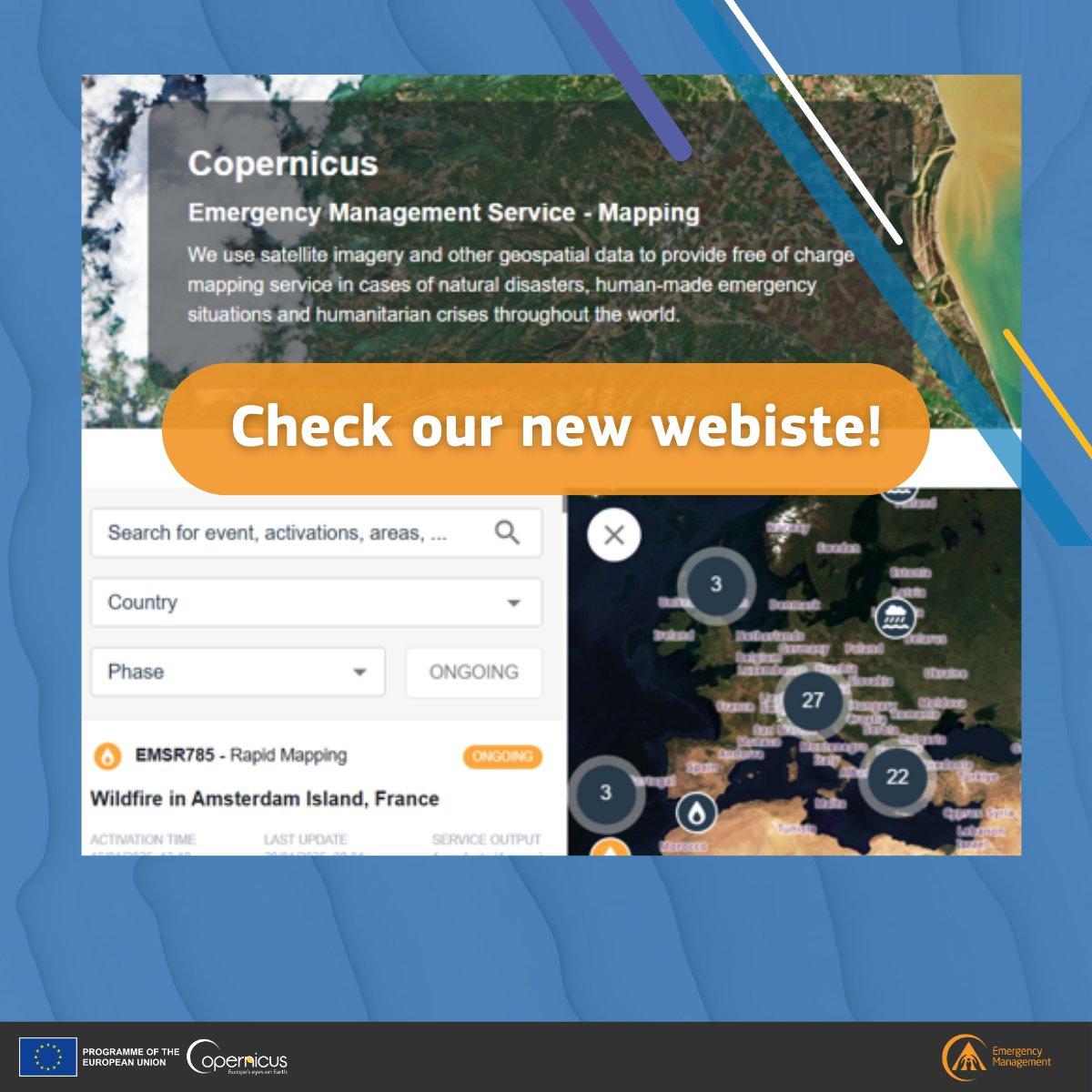
💻 The new Copernicus EMS On-Demand Mapping website is live! We revamped the platform's features to make it the central hub for accessing all activation products, data, and information. 👇 Explore it now 🔗
0
17
28
🚀 Coming Soon: Our new On-Demand Mapping website! Get ready! On Monday 3 February, we're launching the revamped CEMS On-Demand Mapping platform—your go-to hub for activation products, emergency maps and data. 🔜 More info 🔗

0
4
12
🌊 The 4th CEMS Global Flood Forecasting & Monitoring Meeting will take place on April 2-3. You will get updated on the latest changes in our products and data through online interactive sessions and hands-on workshops. 📆 Save you seat! 🔗

0
7
6